Dawa-Cheffa Traditional Checkdam
(Etiópia)
Kiter
Descrição
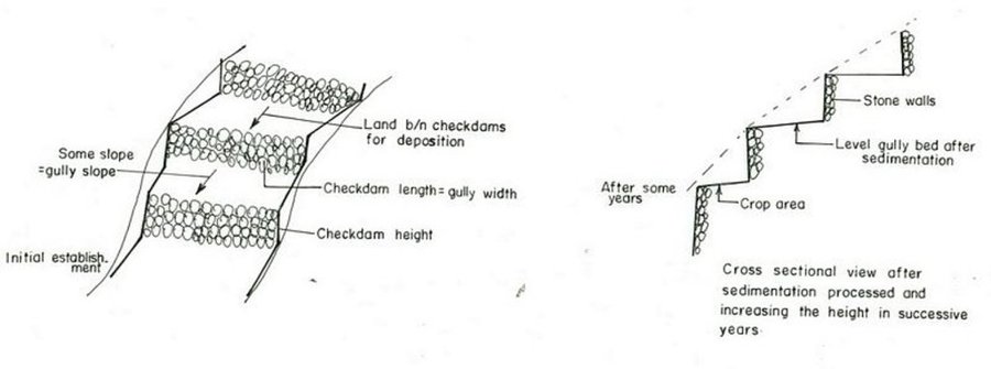
A structural measure constructed by stone/soil/wood acrross the gully to control erosion and create favourble condition for crop cultivation.
The technology is known by the farmers for more than a century. Since the area is highly affected by gully erosion, this practice is widely used by farmers in the area and also widely practiced. Its construction starts from the bottom of the gully and proceeds upslope with different dimensions. The height depends on the depth of the gully and it is increased from year to year. On the average the width is 1m and hieght is 1.80m. The technology is used to develop big gullies and treatment of small gully like depressions, attain slope change to enhance land suitability to crop production and to conserve soil and water. The construction of the stone checkdam starts with small heights and some height is added every year until the intended height is reached. The increase in height could be done during maintenance also. The major objective being to stop gully growth, trap sediment and retain water running down the gully. In the course of increasing the height, the area for sediment deposition gets wider. The technology is suitable to areas with low rainfalls of rugged topography having a network of gullies.
Localização
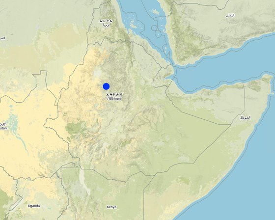
Localização: Koshem Watershed, Amhara Regional State, Etiópia
Nº de sites de tecnologia analisados:
Geo-referência de locais selecionados
Difusão da tecnologia: Uniformemente difundida numa área (approx. 10-100 km2)
Em uma área permanentemente protegida?:
Data da implementação: mais de 50 anos atrás (tradicional)
Tipo de introdução
-
atráves de inovação dos usuários da terra
-
Como parte do sistema tradicional (>50 anos)
-
durante experiências/ pesquisa
-
através de projetos/intervenções externas
Classificação da Tecnologia
Objetivo principal
-
Melhora a produção
-
Reduz, previne, recupera a degradação do solo
-
Preserva ecossistema
-
Protege uma bacia/zonas a jusante – em combinação com outra tecnologia
-
Preservar/melhorar a biodiversidade
-
Reduzir riscos de desastre
-
Adaptar a mudanças climáticas/extremos e seus impactos
-
Atenuar a mudanças climáticas e seus impactos
-
Criar impacto econômico benéfico
-
Cria impacto social benéfico
Uso da terra
-
Terra de cultivo
- Cultura anual: cereais - milho, cereais - sorgo, Legumes e leguminosas - feijão, Legumes e leguminosas - outras, culturas oleaginosas - girassol, colza, outros, haricot bean, teff
- Cultura perene (não lenhosa)
- Cultura de árvores e arbustos: cítrico, café, cultivado ao ar livre, frutas, outros, manga, mangostão, goiaba, mamão, acacia, eucalyptus, khata edulis, ageava sisal, banana, lemon
Número de estações de cultivo por ano: 2
O cultivo entre culturas é praticado? Sim
-
Floresta/bosques
- Florestas/bosques (semi)naturais. Gestão: Derrubada descontrolada
Produtos e serviços: Madeira, Lenha, Pastagem/Alimentação de folhas e brotos
Abastecimento de água
-
Precipitação natural
-
Misto de precipitação natural-irrigado
-
Irrigação completa
Objetivo relacionado à degradação da terra
-
Prevenir degradação do solo
-
Reduzir a degradação do solo
-
Recuperar/reabilitar solo severamente degradado
-
Adaptar à degradação do solo
-
Não aplicável
Degradação abordada
-
Erosão do solo pela água - Wt: Perda do solo superficial/erosão de superfície, Wg: Erosão por ravinas/ravinamento
-
Deteriorização química do solo - Cn: declínio de fertilidade e teor reduzido de matéria orgânica (não causado pela erosão)
Grupo de GST
-
Gestão de água de superfície (nascente, rio, lagos, mar)
Medidas de GST
-
Medidas agronômicas - A1: cobertura vegetal/do solo, A2: Matéria orgânica/fertilidade do solo, A3: Tratamento da superfície do solo, A6: Gerenciamento de resíduos, A7: Outros
-
Medidas estruturais - S6: Muros, barreiras, paliçadas, cercas
Desenho técnico
Especificações técnicas
Amhara
Technical knowledge required for field staff / advisors: high
Technical knowledge required for land users: moderate
Main technical functions: increase / maintain water stored in soil, sediment retention / trapping, sediment harvesting
Secondary technical functions: reduction of slope angle, reduction of slope length, increase of infiltration
Mixed cropping / intercropping
Material/ species: sorghum/maize +haricot beans
Quantity/ density: 70,000 sor
Remarks: broadcast
Agronomic measure: mixed cropping / intercropping
Material/ species: teff + sunflower
Quantity/ density: -
Remarks: broadcast
Manure / compost / residues
Material/ species: Animal dung, fuelwood ash, leaves, soil
Quantity/ density: 0.6 ton/ha
Contour tillage
Remarks: along contour
Agronomic measure: Sediment trapped by checkdam
Remarks: along the contour
Agronomic measure: Seedbed preparation by hoe
Aligned: -contour
Vegetative material: T : trees / shrubs
Number of plants per (ha): 1500
Vertical interval between rows / strips / blocks (m): 1-1.8m
Spacing between rows / strips / blocks (m): 8-10m
Vertical interval within rows / strips / blocks (m): 1-2m
Width within rows / strips / blocks (m): 1x1
Vegetative measure: aligned: contour
Vegetative material: G : grass
Number of plants per (ha): -
Vertical interval between rows / strips / blocks (m): 1-1.8m
Spacing between rows / strips / blocks (m): 8-10m
Vertical interval within rows / strips / blocks (m): -
Width within rows / strips / blocks (m): -
Vegetative measure: aligned: contour
Vegetative material: G : grass
Number of plants per (ha): 2000
Vertical interval between rows / strips / blocks (m): 1-1.8m
Spacing between rows / strips / blocks (m): 8-10m
Vertical interval within rows / strips / blocks (m): -
Width within rows / strips / blocks (m): -
Vegetative measure: Vegetative material: G : grass
Vegetative measure: Vegetative material: G : grass
Trees/ shrubs species: acacia, eucalyptus, khata edulis, ageava sisal
Fruit trees / shrubs species: coffee, papaya, guava, banana, lemon, manago, orange
Grass species: elephant grass, local grass
Slope (which determines the spacing indicated above): 12.00%
If the original slope has changed as a result of the Technology, the slope today is (see figure below): 3.00%
Gradient along the rows / strips: 0.00%
Structural measure: Checkdam
Vertical interval between structures (m): 1
Spacing between structures (m): 8m
Depth of ditches/pits/dams (m): 0.3m
Width of ditches/pits/dams (m): 1m
Length of ditches/pits/dams (m): 5m
Height of bunds/banks/others (m): 0.5-1m
Width of bunds/banks/others (m): 1m
Length of bunds/banks/others (m): 5.m
Construction material (earth): Soil is embnked upslope of the stone wall as reinforcement
Construction material (stone): Stone is used to construct the embankment/wall/and is supported by soil in the upslope side to reinf
Construction material (wood): Wood used as support at the downslope side
Slope (which determines the spacing indicated above): 12%
If the original slope has changed as a result of the Technology, the slope today is: 3%
Lateral gradient along the structure: 0%
For water harvesting: the ratio between the area where the harvested water is applied and the total area from which water is collected is: 1:3
Vegetation is used for stabilisation of structures.
Change of land use type: gully converted to cropland
Other type of management: fencing and guarding - protect animals from interering to plantations
Estabelecimento e manutenção: atividades, insumos e custos
Cálculo de insumos e custos
- Os custos são calculados:
- Moeda utilizada para o cálculo de custos: Birr
- Taxa de câmbio (para USD): 1 USD = 8.6 Birr
- Custo salarial médio da mão-de-obra contratada por dia: 0.70
Fatores mais importantes que afetam os custos
labour, slope and depth of the gully, width of the gully, availability of construction material, soil depth. The establishment cost considerts the cost incurred over 15 years.
Atividades de implantação
-
Seedling production (Periodicidade/frequência: March to June)
-
Planting (Periodicidade/frequência: June to July)
-
Excavation (Periodicidade/frequência: dry season)
-
Stone collection (Periodicidade/frequência: dry season)
-
Construction (Periodicidade/frequência: dry season)
-
Fencing (Periodicidade/frequência: after plantation)
Estabelecer insumos e custos
| Especifique a entrada |
Unidade |
Quantidade |
Custos por unidade (Birr) |
Custos totais por entrada (Birr) |
% dos custos arcados pelos usuários da terra |
|
Mão-de-obra
|
| Labour |
ha |
1,0 |
4625,0 |
4625,0 |
90,0 |
|
Equipamento
|
| Tools |
ha |
1,0 |
120,0 |
120,0 |
95,0 |
|
Material de construção
|
| Stone |
ha |
1,0 |
|
|
100,0 |
| Custos totais para a implantação da tecnologia |
4'745.0 |
|
| Custos totais para o estabelecimento da Tecnologia em USD |
551.74 |
|
Atividades de manutenção
-
clean crop residue (Periodicidade/frequência: Early January /)
-
primary digging (Periodicidade/frequência: Feb-March /)
-
harrowing (Periodicidade/frequência: March /)
-
manure application (Periodicidade/frequência: March /)
-
planting (Periodicidade/frequência: April /)
-
weeding and cultivation (Periodicidade/frequência: Late June-August /)
-
harvest (Periodicidade/frequência: November-December /)
-
replanting (Periodicidade/frequência: during rains /once a year)
-
pruning and thining (Periodicidade/frequência: dry season /once a year)
-
Stone collection (Periodicidade/frequência: dry season/once a year)
-
Placing the stones where maintenance is required (Periodicidade/frequência: dry season/once a year)
-
repairing breaks in fences (Periodicidade/frequência: before replanting / annual)
Insumos e custos de manutenção
| Especifique a entrada |
Unidade |
Quantidade |
Custos por unidade (Birr) |
Custos totais por entrada (Birr) |
% dos custos arcados pelos usuários da terra |
|
Mão-de-obra
|
| Labour |
ha |
1,0 |
624,0 |
624,0 |
100,0 |
|
Equipamento
|
| Tools |
ha |
1,0 |
30,0 |
30,0 |
100,0 |
|
Material de construção
|
| Stone |
ha |
1,0 |
|
|
100,0 |
| Custos totais para a manutenção da tecnologia |
654.0 |
|
| Custos totais de manutenção da Tecnologia em USD |
76.05 |
|
Ambiente natural
Média pluviométrica anual
-
<250 mm
-
251-500 mm
-
501-750 mm
-
751-1.000 mm
-
1.001-1.500 mm
-
1.501-2.000 mm
-
2.001-3.000 mm
-
3.001-4.000 mm
-
> 4.000 mm
Zona agroclimática
-
úmido
-
Subúmido
-
Semiárido
-
Árido
Especificações sobre o clima
Specification 500-750 mm (600mm)
Specification 750-1000 mm (900mm)
Semi-arid: In the SWC area the semiarid part is about 70%
Sub-humid: Comprises about 30%
Inclinação
-
Plano (0-2%)
-
Suave ondulado (3-5%)
-
Ondulado (6-10%)
-
Moderadamente ondulado (11-15%)
-
Forte ondulado (16-30%)
-
Montanhoso (31-60%)
-
Escarpado (>60%)
Formas de relevo
-
Planalto/planície
-
Cumes
-
Encosta de serra
-
Encosta de morro
-
Sopés
-
Fundos de vale
Altitude
-
0-100 m s.n.m.
-
101-500 m s.n.m.
-
501-1.000 m s.n.m.
-
1.001-1.500 m s.n.m.
-
1.501-2.000 m s.n.m.
-
2.001-2.500 m s.n.m.
-
2.501-3.000 m s.n.m.
-
3.001-4.000 m s.n.m.
-
> 4.000 m s.n.m.
A tecnologia é aplicada em
-
Posições convexas
-
Posições côncavas
-
Não relevante
Profundidade do solo
-
Muito raso (0-20 cm)
-
Raso (21-50 cm)
-
Moderadamente profundo (51-80 cm)
-
Profundo (81-120 cm)
-
Muito profundo (>120 cm)
Textura do solo (superficial)
-
Grosso/fino (arenoso)
-
Médio (limoso, siltoso)
-
Fino/pesado (argila)
Textura do solo (>20 cm abaixo da superfície)
-
Grosso/fino (arenoso)
-
Médio (limoso, siltoso)
-
Fino/pesado (argila)
Teor de matéria orgânica do solo superior
-
Alto (>3%)
-
Médio (1-3%)
-
Baixo (<1%)
Lençol freático
-
Na superfície
-
< 5 m
-
5-50 m
-
> 50 m
Disponibilidade de água de superfície
-
Excesso
-
Bom
-
Médio
-
Precário/nenhum
Qualidade da água (não tratada)
-
Água potável boa
-
Água potável precária (tratamento necessário)
-
apenas para uso agrícola (irrigação)
-
Inutilizável
A salinidade é um problema?
Ocorrência de enchentes
Características dos usuários da terra que utilizam a tecnologia
Orientação de mercado
-
Subsistência (autoabastecimento)
-
misto (subsistência/comercial)
-
Comercial/mercado
Rendimento não agrícola
-
Menos de 10% de toda renda
-
10-50% de toda renda
-
>50% de toda renda
Nível relativo de riqueza
-
Muito pobre
-
Pobre
-
Média
-
Rico
-
Muito rico
Nível de mecanização
-
Trabalho manual
-
Tração animal
-
Mecanizado/motorizado
Sedentário ou nômade
-
Sedentário
-
Semi-nômade
-
Nômade
Indivíduos ou grupos
-
Indivíduo/unidade familiar
-
Grupos/comunidade
-
Cooperativa
-
Empregado (empresa, governo)
Idade
-
Crianças
-
Jovens
-
meia-idade
-
idosos
Área utilizada por residência
-
< 0,5 ha
-
0,5-1 ha
-
1-2 ha
-
2-5 ha
-
5-15 ha
-
15-50 ha
-
50-100 ha
-
100-500 ha
-
500-1.000 ha
-
1.000-10.000 ha
-
> 10.000 ha
Escala
-
Pequena escala
-
Média escala
-
Grande escala
Propriedade da terra
-
Estado
-
Empresa
-
Comunitário/rural
-
Grupo
-
Indivíduo, não intitulado
-
Indivíduo, intitulado
Direitos do uso da terra
-
Acesso livre (não organizado)
-
Comunitário (organizado)
-
Arrendado
-
Indivíduo
Direitos do uso da água
-
Acesso livre (não organizado)
-
Comunitário (organizado)
-
Arrendado
-
Indivíduo
Acesso a serviços e infraestrutura
Impactos
Impactos socioeconômicos
Produção agrícola
The cost benefit anlysis for sorghum shows negative profit but for other crops such as combination of coffe, papaya, chat the profit is high
Rendimento agrícola
for cropping patterns which consider field crops + cash crops is high
Impactos socioculturais
Conhecimento de GST/ degradação da terra
Impactos ecológicos
Escoamento superficial
Quantidade anterior à GST: 70
Quantidade posterior à GST: 5
Umidade do solo
soil depth increased by depostion infiltration enhanced
Perda de solo
Quantidade anterior à GST: 10
Quantidade posterior à GST: 0
checdams decrease gully slope
Soil fertility
Fertile top soil erdoed upslope is trapped in the gully
Biodiversity
combined application of useful plants and crop
Impactos fora do local
Caudal confiável e estável em período seco (inclusive baixo caudal)
high percolation rate of rain water
Cheias de jusante (indesejada)
runoff is trapped by supportive technologies undertaken in the upper catchment and runoof velocity retarded by checkdams
Sedimentação a jusante
sediment trapped in the gullies
Análise do custo-benefício
Benefícios em relação aos custos de estabelecimento
Retornos a curto prazo
muito negativo
muito positivo
Retornos a longo prazo
muito negativo
muito positivo
Benefícios em relação aos custos de manutenção
Retornos a curto prazo
muito negativo
muito positivo
Retornos a longo prazo
muito negativo
muito positivo
Adoção e adaptação
Porcentagem de usuários de terras na área que adotaram a Tecnologia
-
casos isolados/experimental
-
1-10%
-
11-50%
-
> 50%
De todos aqueles que adotaram a Tecnologia, quantos o fizeram sem receber incentivos materiais?
-
0-10%
-
11-50%
-
51-90%
-
91-100%
Número de residências e/ou área coberta
25000
A tecnologia foi recentemente modificada para adaptar-se as condições variáveis?
A quais condições de mudança?
-
Mudança climática/extremo
-
Mercados dinâmicos
-
Disponibilidade de mão-de-obra (p. ex. devido à migração)
Conclusões e experiências adquiridas
Pontos fortes: visão do usuário de terra
-
Land reclaimed
How can they be sustained / enhanced? fertility of soils increased by accumulated top soil from other area.
-
retain moisture
How can they be sustained / enhanced? water stored in the soil.
Pontos fortes: a visão do/a compilador/a ou de outra pessoa capacitada
-
Reduce runoff speed
How can they be sustained / enhanced? exercise frequent maintenance and stablize the structure with vegetative measures
-
Reduce soil loss
How can they be sustained / enhanced? soil is trapped by the checkdam
-
Moisture retention
How can they be sustained / enhanced? the soil trapped provides more space for water to be stored.
-
reduce slope length
How can they be sustained / enhanced? by raising the gully bed.
Pontos fracos/desvantagens/riscos: visão do usuário de terracomo superar
Pontos fracos/desvantagens/riscos: a visão do/a compilador/a ou de outra pessoa capacitadacomo superar
Referências
Revisor
-
Fabian Ottiger
-
Alexandra Gavilano
Data da documentação: 29 de Maio de 2011
Última atualização: 9 de Setembro de 2019
Pessoas capacitadas
-
Kemal Umer - Especialista em GST
Descrição completa no banco de dados do WOCAT
A documentação foi facilitada por
Instituição
- Ministry of Agriculture and Rural Development of Ethiopia (Ministry of Agriculture and Rural Development) - Etiópia
Projeto
Referências-chave
-
Monthly, quarterly and annual achievement reports of the DWARDO:
-
Work norm of MERET:
-
Ethiopian Highlands Reclamation stdy:
-
Soil and water conservation , Morgan 1986: