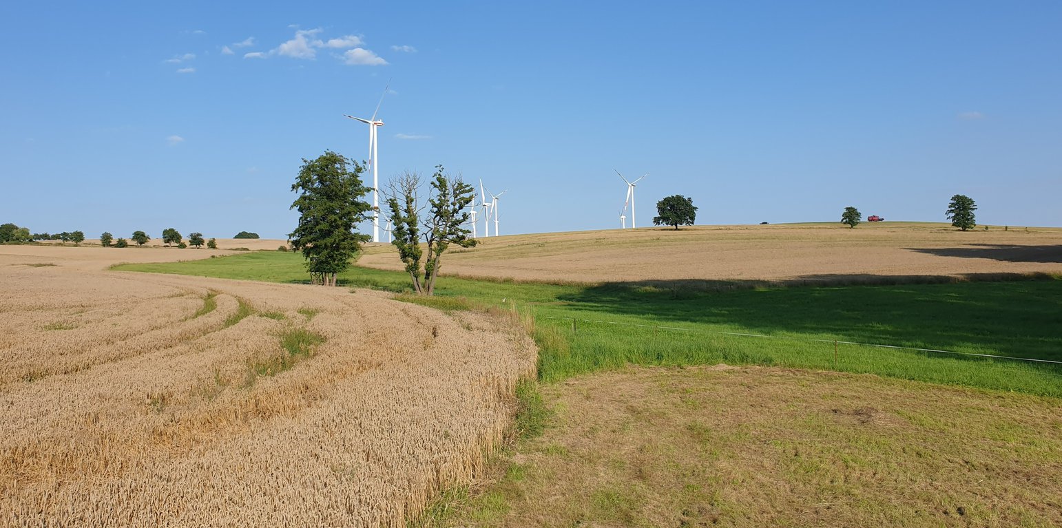
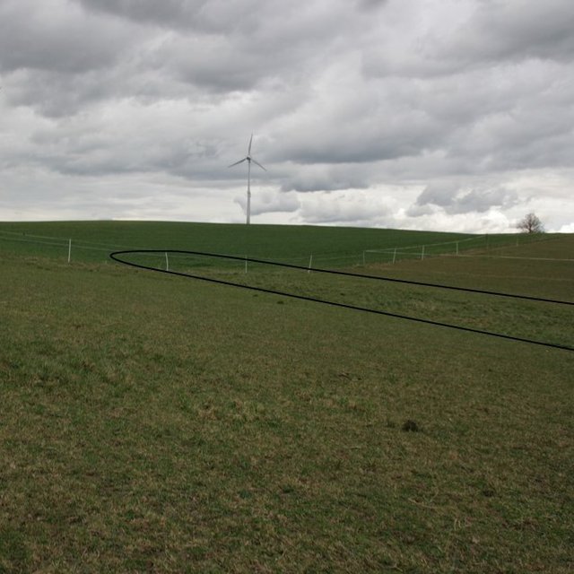
Example of a "grassed waterway" in the catchment area. (Felix Witing)

Grassed waterways (Alemanha)

Dauerbegrünung erosionsgefährdeter Abflussbahnen

Descrição

A grassed waterway is a strip of grass and other permanent low growing vegetation that is established along in the main drainage line (the thalweg) of an agricultural field to discharge water safely and prevent gully development.

In order to prevent gully erosion along main drainage lines (thalwegs), grassed waterways, composed of grass and other permanent low growing vegetation, are established to discharge water safely. The grassed waterway slows down the surface runoff in the thalweg, increases infiltration and stabilizes the soil surface. This reduces soil erosion by water and the associated runoff of nutrients and pesticides. Fiener et al. (2005) reported a sediment retention of 80-95% and a water retention of 70-90%. Sediment is trapped mainly by water infiltration (infiltration-induced sedimentation) rather than by the filtering effect of vegetation. The conservation value of grassed waterways is not as high as for other measures, but they are still considered as a biotope network as well as a habitat for grassland breeders when extensive management practices are used (LfULG, 2010).
Grassed waterways are typically installed in relatively large arable fields. Normally only the most vulnerable lowest area of the field needs to be grassed. The width of the area to be grassed depends on the size of the drained catchment, the physiographic characteristics of the discharge pathway (channel shape, bottom slope) and the land management (e.g. working width of the agricultural machinery). The United States Department of Agriculture (2020) recommends a total width of the grassed waterway of about 6 m in the upper part and 15 m in the lower part. On average, a grassed waterway should occupy 2% of the catchment area (LfULG, 2015).
During the establishment of the vegetation, it is recommended to protect and stabilize the young plants against strong water flows, by temporary measures such as silt fences or mulching. Once the vegetation is dense enough to withstand heavy rain events, these temporary measures should be removed. After each heavy rainfall event, the waterway should be inspected for damage. Damaged areas should be filled and reseeded, and sediment deposits should be removed.
The choice of the seed mixture depends on the intended use and maintenance of the grassed waterway. A combination of trees and grass increases infiltration rates and natural values. Mowing should be done at least once a year, otherwise, shrubs will establish and suppress the grass. The grassed waterway should not be used as a track for vehicles because of soil compaction, and damage to vegetation. Where possible, tillage should be across the slope – therefore perpendicular to the grassed waterway in order to avoid furrows developing parallel to the waterway. A combination with conservation tillage or other erosion control practices is highly recommended (LfULG, 2010).
Grassed waterways involve a permanent change in land-use, which means a loss of cultivable area, and associated loss of yield - and of income too if it is not covered by subsidies. Many land users dislike such structures in their fields as they impede machinery. Because land users are not always the landowners, they are not always allowed to make permanent changes in land-use. In Germany, a grassland becomes permanent after 5 years. Thus, many farmers decide to plough and replant such grassed areas every 5 years.

The landowner in our documentation had suffered from lodging of his oat crop along the drainage path due to heavy rainfall. Thus, he decided to undesow the oats with ryegrass. In the following year, the undersown ryegrass developed better than the oats and the farmer decided to establish ryegrass as the main crop over the whole field – rather then just in the thalweg, to avoid having to drive around it. Now he mows the area once in the spring for silage and then uses it as pasture for his horses. Every five years, he has to plough the whole area and replant it with ryegrass to prevent it from becoming permanent grassland.
Localização

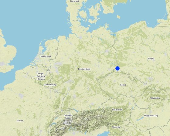
Localização: Saxony, Alemanha

Nº de sites de tecnologia analisados: Local único

Geo-referência de locais selecionados
  • 14.7792, 51.14017

Difusão da tecnologia: Aplicado em pontos específicos/concentrado numa pequena área

Em uma área permanentemente protegida?: Não

Data da implementação: 2022; menos de 10 anos atrás (recentemente)

Tipo de introdução
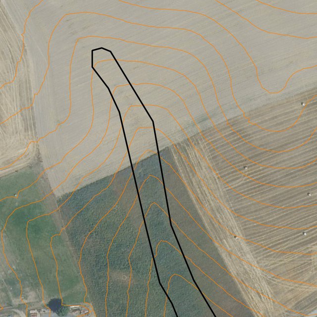
Runoff path designated by the LfULG as being particularly at risk of erosion (Data set: Map of runoff pathways that are at particular risk of erosion (vector data; Görlitz district; LfULG Saxony))
Detailed: plotted potential grassed waterway on the field (Michael Strauch)

Classificação da Tecnologia

Objetivo principal
  • Melhora a produção
  • Reduz, previne, recupera a degradação do solo
  • Preserva ecossistema
  • Protege uma bacia/zonas a jusante – em combinação com outra tecnologia
  • Preservar/melhorar a biodiversidade
  • Reduzir riscos de desastre
  • Adaptar a mudanças climáticas/extremos e seus impactos
  • Atenuar a mudanças climáticas e seus impactos
  • Criar impacto econômico benéfico
  • Cria impacto social benéfico
Uso da terra
Uso do solo misturado dentro da mesma unidade de terra: Sim - Agropecuária (incl. agricultura e pecuária)

  • Terra de cultivo
    • Cultura anual: culturas forrageiras - gramíneas, german rye grass
    Número de estações de cultivo por ano: 1
    O cultivo entre culturas é praticado? Não
    O rodízio de culturas é praticado? Não
  • Pastagem
    • Pastos melhorados
    Tipo de animal: cavalos
    É praticado o manejo integrado de culturas e pecuária? Sim
    Produtos e serviços: estrume como fertilizante/ produção de energia
      EspécieContagem
      cavalos2
    Abastecimento de água
    • Precipitação natural
    • Misto de precipitação natural-irrigado
    • Irrigação completa

    Objetivo relacionado à degradação da terra
    • Prevenir degradação do solo
    • Reduzir a degradação do solo
    • Recuperar/reabilitar solo severamente degradado
    • Adaptar à degradação do solo
    • Não aplicável
    Degradação abordada
    • Erosão do solo pela água - Wt: Perda do solo superficial/erosão de superfície, Wg: Erosão por ravinas/ravinamento
    • Erosão do solo pelo vento - Et: Perda do solo superficial
    • Deteriorização química do solo - Cn: declínio de fertilidade e teor reduzido de matéria orgânica (não causado pela erosão)
    • Deteriorização física do solo - Pc: Compactação, Pk: quebra e ressecamento
    • Degradação biológica - Bc: redução da cobertura vegetal, Bh: perda dos habitats, Bl: perda da vida do solo
    • Degradação da água - Hs: mudança na quantidade de água de superfície
    Grupo de GST
    • Solo/cobertura vegetal melhorada
    • Desvio e drenagem de água
    Medidas de GST
    • Medidas vegetativas - V2: gramíneas e plantas herbáceas perenes

    Desenho técnico

    Especificações técnicas
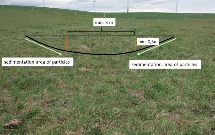
    Normally, only the vulnerable lowest area of an agricultural field ( channel shape, bottom slope) needs to be grassed. LfULG recommends 1-4 m wide side slopes with a passable gradient of 1:10 (10%) and a total width of the upper slope of about 6 m and 15 m for the lower slope. The bottom of the drainage channel must be at least 3 m wide and 0.3 m deep. The side slopes are responsible for sedimentation of particles and the bottom for infiltration of water.
    Author: Mona Pauer based on LfULG 2010, p.27
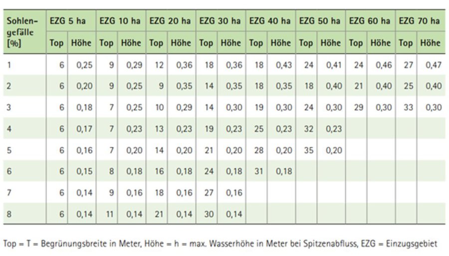
    Guide values for the width (Top) of drainage channels depending on the size of the catchment area (EZG), the slope of the riverbed (Sohlengefälle) and the height (Höhe) of the drainage channel.
    Author: LfULG 2015, p. 7

    Estabelecimento e manutenção: atividades, insumos e custos

    Cálculo de insumos e custos
    • Os custos são calculados: por área de tecnologia (tamanho e unidade de área: 1 ha)
    • Moeda utilizada para o cálculo de custos:
    • Taxa de câmbio (para USD): 1 USD = 0.91 €
    • Custo salarial médio da mão-de-obra contratada por dia: 18.70 € per hour
    Fatores mais importantes que afetam os custos
    Landowners complained that the additional yield (grass as fodder) would have no impact on their income. The loss of income due to the loss of arable land is greater and should be compensated by subsidy programs.
    Atividades de implantação
    1. reseeding of ryegrass (drill seed) (Periodicidade/frequência: spring)
    2. rolling (soil contact between plant and soil) (Periodicidade/frequência: spring)
    Estabelecer insumos e custos (per 1 ha)
    Especifique a entrada Unidade Quantidade Custos por unidade (€) Custos totais por entrada (€) % dos custos arcados pelos usuários da terra
    Mão-de-obra
    seeding ha 1,0 20,19 20,19 100,0
    rolling ha 1,0 19,58 19,58 100,0
    Material vegetal
    seeds ha 1,0 32,4 32,4 100,0
    Custos totais para a implantação da tecnologia 72.17
    Custos totais para o estabelecimento da Tecnologia em USD 79.31
    Atividades de manutenção
    1. mulching (Periodicidade/frequência: every spring)
    2. ploughing (Periodicidade/frequência: every 5 years)
    3. reseeding (Periodicidade/frequência: every 5 years)
    Insumos e custos de manutenção (per 1 ha)
    Especifique a entrada Unidade Quantidade Custos por unidade (€) Custos totais por entrada (€) % dos custos arcados pelos usuários da terra
    Mão-de-obra
    mulching ha 1,0 24,87 24,87 100,0
    ploughing ha 0,2 63,56 12,71 100,0
    reseeding ha 0,2 39,77 7,95 100,0
    Material vegetal
    seeds 32,4 0,2 32,4 6,48 100,0
    Custos totais para a manutenção da tecnologia 52.01
    Custos totais de manutenção da Tecnologia em USD 57.15

    Ambiente natural

    Média pluviométrica anual
    • <250 mm
    • 251-500 mm
    • 501-750 mm
    • 751-1.000 mm
    • 1.001-1.500 mm
    • 1.501-2.000 mm
    • 2.001-3.000 mm
    • 3.001-4.000 mm
    • > 4.000 mm
    Zona agroclimática
    • úmido
    • Subúmido
    • Semiárido
    • Árido
    Especificações sobre o clima
    Pluviosidade média anual em mm: 775.0
    Nome da estação meteorológica: https://whh-kliwes.de/mapview
    LGP: 209 days (https://www.umwelt.sachsen.de/dauer-der-vegetationsperiode-30631.html)
    Inclinação
    • Plano (0-2%)
    • Suave ondulado (3-5%)
    • Ondulado (6-10%)
    • Moderadamente ondulado (11-15%)
    • Forte ondulado (16-30%)
    • Montanhoso (31-60%)
    • Escarpado (>60%)
    Formas de relevo
    • Planalto/planície
    • Cumes
    • Encosta de serra
    • Encosta de morro
    • Sopés
    • Fundos de vale
    Altitude
    • 0-100 m s.n.m.
    • 101-500 m s.n.m.
    • 501-1.000 m s.n.m.
    • 1.001-1.500 m s.n.m.
    • 1.501-2.000 m s.n.m.
    • 2.001-2.500 m s.n.m.
    • 2.501-3.000 m s.n.m.
    • 3.001-4.000 m s.n.m.
    • > 4.000 m s.n.m.
    A tecnologia é aplicada em
    • Posições convexas
    • Posições côncavas
    • Não relevante
    Profundidade do solo
    • Muito raso (0-20 cm)
    • Raso (21-50 cm)
    • Moderadamente profundo (51-80 cm)
    • Profundo (81-120 cm)
    • Muito profundo (>120 cm)
    Textura do solo (superficial)
    • Grosso/fino (arenoso)
    • Médio (limoso, siltoso)
    • Fino/pesado (argila)
    Textura do solo (>20 cm abaixo da superfície)
    • Grosso/fino (arenoso)
    • Médio (limoso, siltoso)
    • Fino/pesado (argila)
    Teor de matéria orgânica do solo superior
    • Alto (>3%)
    • Médio (1-3%)
    • Baixo (<1%)
    Lençol freático
    • Na superfície
    • < 5 m
    • 5-50 m
    • > 50 m
    Disponibilidade de água de superfície
    • Excesso
    • Bom
    • Médio
    • Precário/nenhum
    Qualidade da água (não tratada)
    • Água potável boa
    • Água potável precária (tratamento necessário)
    • apenas para uso agrícola (irrigação)
    • Inutilizável
    A qualidade da água refere-se a: água de superfície
    A salinidade é um problema?
    • Sim
    • Não

    Ocorrência de enchentes
    • Sim
    • Não
    Diversidade de espécies
    • Alto
    • Médio
    • Baixo
    Diversidade de habitat
    • Alto
    • Médio
    • Baixo

    Características dos usuários da terra que utilizam a tecnologia

    Orientação de mercado
    • Subsistência (autoabastecimento)
    • misto (subsistência/comercial)
    • Comercial/mercado
    Rendimento não agrícola
    • Menos de 10% de toda renda
    • 10-50% de toda renda
    • >50% de toda renda
    Nível relativo de riqueza
    • Muito pobre
    • Pobre
    • Média
    • Rico
    • Muito rico
    Nível de mecanização
    • Trabalho manual
    • Tração animal
    • Mecanizado/motorizado
    Sedentário ou nômade
    • Sedentário
    • Semi-nômade
    • Nômade
    Indivíduos ou grupos
    • Indivíduo/unidade familiar
    • Grupos/comunidade
    • Cooperativa
    • Empregado (empresa, governo)
    Gênero
    • Mulheres
    • Homens
    Idade
    • Crianças
    • Jovens
    • meia-idade
    • idosos
    Área utilizada por residência
    • < 0,5 ha
    • 0,5-1 ha
    • 1-2 ha
    • 2-5 ha
    • 5-15 ha
    • 15-50 ha
    • 50-100 ha
    • 100-500 ha
    • 500-1.000 ha
    • 1.000-10.000 ha
    • > 10.000 ha
    Escala
    • Pequena escala
    • Média escala
    • Grande escala
    Propriedade da terra
    • Estado
    • Empresa
    • Comunitário/rural
    • Grupo
    • Indivíduo, não intitulado
    • Indivíduo, intitulado
    Direitos do uso da terra
    • Acesso livre (não organizado)
    • Comunitário (organizado)
    • Arrendado
    • Indivíduo
    Direitos do uso da água
    • Acesso livre (não organizado)
    • Comunitário (organizado)
    • Arrendado
    • Indivíduo
    Acesso a serviços e infraestrutura
    Saúde

    Pobre
    x
    Bom
    Educação

    Pobre
    x
    Bom
    Assistência técnica

    Pobre
    x
    Bom
    Emprego (p. ex. não agrícola)

    Pobre
    x
    Bom
    Mercados

    Pobre
    x
    Bom
    Energia

    Pobre
    x
    Bom
    Vias e transporte

    Pobre
    x
    Bom
    Água potável e saneamento

    Pobre
    x
    Bom
    Serviços financeiros

    Pobre
    x
    Bom

    Impactos

    Impactos socioeconômicos
    Produção de forragens
    diminuído
    x
    aumentado


    The loss of arable land (used for forage oats) cannot be compensated by harvesting grass on the runoff path.

    Qualidade da forragem
    diminuído
    x
    aumentado

    Risco de falha de produção
    aumentado
    x
    diminuído

    Área de produção (nova terra sob cultivo/uso)
    diminuído
    x
    aumentado


    Measure does not affect yield, but means a loss of area.

    Despesas com insumos agrícolas
    aumentado
    x
    diminuído


    Costs for seeds

    Rendimento agrícola
    diminuído
    x
    aumentado

    Diversidade de fontes de rendimento
    diminuído
    x
    aumentado

    Carga de trabalho
    aumentado
    x
    diminuído


    If a whole field is converted to a grassed waterway workload decreases. However, for a typical grassed waterway (just greening of the thalweg) an increase in workload can be expected.

    Impactos socioculturais
    Impactos ecológicos
    Escoamento superficial
    aumentado
    x
    diminuído


    Reduction in surface water runoff.

    Umidade do solo
    diminuído
    x
    aumentado

    Cobertura do solo
    Reduzido
    x
    Melhorado

    Perda de solo
    aumentado
    x
    diminuído

    Acumulação de solo
    diminuído
    x
    aumentado

    Compactação do solo
    aumentado
    x
    Reduzido

    Matéria orgânica do solo/carbono abaixo do solo
    diminuído
    x
    aumentado

    Cobertura vegetal
    diminuído
    x
    aumentado

    Diversidade vegetal
    diminuído
    x
    aumentado

    Espécies exóticas invasoras
    aumentado
    x
    Reduzido

    Diversidade de habitat
    diminuído
    x
    aumentado

    Controle de praga/doença
    diminuído
    x
    aumentado

    Impactos da seca
    aumentado
    x
    diminuído

    Impactos fora do local
    disponibilidade de água (lençóis freáticos, nascentes)
    diminuído
    x
    aumentado

    Poluição de água subterrânea/rio
    aumentado
    x
    Reduzido

    Capacidade de tamponamento/filtragem (pelo solo, vegetação, zonas úmidas)
    Reduzido
    x
    Melhorado

    Danos em áreas vizinhas
    aumentado
    x
    Reduzido

    Danos na infraestrutura pública/privada
    aumentado
    x
    Reduzido


    No more soil deposits in the yard/on the street.

    Análise do custo-benefício

    Benefícios em relação aos custos de estabelecimento
    Retornos a curto prazo
    muito negativo
    x
    muito positivo

    Retornos a longo prazo
    muito negativo
    x
    muito positivo

    Benefícios em relação aos custos de manutenção
    Retornos a curto prazo
    muito negativo
    x
    muito positivo

    Retornos a longo prazo
    muito negativo
    x
    muito positivo

    Mudança climática

    Mudança climática gradual
    Temperatura sazonal aumento

    não bem em absoluto
    x
    muito bem
    Estação do ano: primavera
    Extremos (desastres) relacionados ao clima
    Temporal local

    não bem em absoluto
    x
    muito bem

    Adoção e adaptação

    Porcentagem de usuários de terras na área que adotaram a Tecnologia
    • casos isolados/experimental
    • 1-10%
    • 11-50%
    • > 50%
    De todos aqueles que adotaram a Tecnologia, quantos o fizeram sem receber incentivos materiais?
    • 0-10%
    • 11-50%
    • 51-90%
    • 91-100%
    A tecnologia foi recentemente modificada para adaptar-se as condições variáveis?
    • Sim
    • Não
    A quais condições de mudança?
    • Mudança climática/extremo
    • Mercados dinâmicos
    • Disponibilidade de mão-de-obra (p. ex. devido à migração)

    Conclusões e experiências adquiridas

    Pontos fortes: visão do usuário de terra
    • Compared to other erosion control measures, the area of the grassed waterway can continue to be used (extensively) for forage and grazing.
    • In Germany, the greened areas could be used as required greening areas for the direct payments of the agricultural policy.
    Pontos fortes: a visão do/a compilador/a ou de outra pessoa capacitada
    • Grassed waterways are highly recommended and beneficial in preventing on-site gully erosion and off-site pollution of water bodies.
    • Due to their more technical background, the conservation value is not as high as for other measures, but they are still considered as a biotope network as well as a habitat for grassland breeders when extensively managed.
    Pontos fracos/desvantagens/riscos: visão do usuário de terracomo superar
    • In Germany, grassland becomes permanent if it is not converted within five years. This often leads to a conflict of interest between landowners and land-users. A permanent change in land-use (from arable land to permanent grassland) would mean a loss in land value. As a result, the farmers plough and reseed the area after five years. With a change in regulations for certain measures, e.g. if land is used for nature conservation, it could remain cropland after five years without being converted.
    • A structure in the middle of a field is impractical in terms of tracks for machinery. Sometimes it may be beneficial to green the entire field or subdivide the field with a linear structure.
    Pontos fracos/desvantagens/riscos: a visão do/a compilador/a ou de outra pessoa capacitadacomo superar

    Referências

    Compilador/a
    • Felix Witing
    Editores
    • Michael Strauch
    • Mona Pauer
    Revisor
    • William Critchley
    • Rima Mekdaschi Studer
    Data da documentação: 22 de Junho de 2021
    Última atualização: 14 de Agosto de 2023
    Pessoas capacitadas
    Descrição completa no banco de dados do WOCAT
    Dados GST vinculados
    A documentação foi facilitada por
    Instituição Projeto
    Links para informação relevante que está disponível online
    This work is licensed under Creative Commons Attribution-NonCommercial-ShareaAlike 4.0 International