Permeable rock dams
(Burkina Faso)
Digues filtrantes (French)
Descrição
Permeable rock dams serve to restore seriously degraded farmland and forest/rangeland and are used to fill in gullies and control water flow.
The permeable rock dam is a structure built in gullies using loose rocks and stones and sometimes reinforced with gabions. A filtering layer (blanket of gravel or small stones) is laid in a foundation trench. Further layers of medium-sized and large stones and rocks are laid on top. They are between 0.50 and 3 metres high, and the width of the foundation and the crest depends on the estimated volume of water flow. The structure built across the gully is extended to the sides with the construction of wingwalls that spread the water over a larger area to the sides of the dam. The total width of the structure is generally at least three times its height. The dams can be constructed with or without a spillway. A spillway is required when flood water flow is stronger.
Purpose of the Technology: Permeable rock dams are used to fill in gullies and control water flow. They slow the flow of floodwaters and spread the water over adjacent land. This improves infiltration, and sediment builds up behind the dams. In time, the sediment fills in the gully. This stops lateral drainage from the land on either side, increasing its productivity. High infiltration upstream of the dam contributes to recharging the groundwater system. These structures are therefore also effective in raising the water table in wells and in protecting the bottom-lands from sand filling and gully erosion. They are used in combination with other measures, such as reforestation and stone bunds, to protect and improve the surrounding area, and to increase the area of land that can be used for growing crops.
By dissipating the flow of floodwaters, they ensure better use of rainwater and are therefore important in dry periods. The conservation of water for longer periods and the fine particles of earth trapped by the structure favour the establishment of natural vegetation along it, which helps to stabilise the dam. Seeds are also trapped, favouring the spontaneous growth of grass and trees upstream and downstream, which contributes to restoring and conserving biodiversity.
Establishment / maintenance activities and inputs: The sustainability of permeable rock dams depends on the quality of construction and whether they are maintained regularly. A certain amount of expertise and good community organisation is required to repair any cracks in
the dam. Biological measures (sowing grass and planting trees) increase the stability of the structure.
The size of a permeable rock dam can vary considerably from one site to another. The cost is also affected by the distance of the site from the quarry, the topography of the terrain and the actual amount of rock carried in each lorryload. It costs less to construct this type of structure with loose stones and rocks than with gabions.
Localização
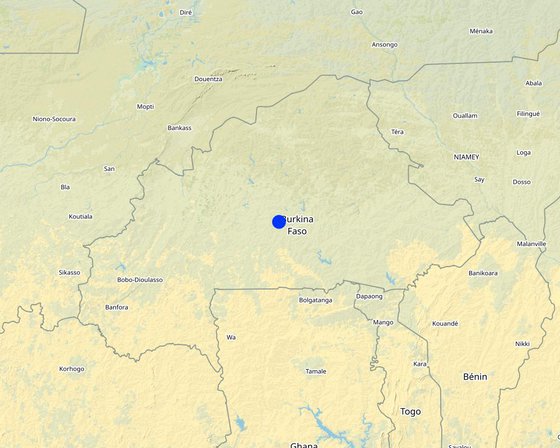
Localização: Burkina Faso, Chad, Burkina Faso
Nº de sites de tecnologia analisados:
Geo-referência de locais selecionados
Difusão da tecnologia:
Em uma área permanentemente protegida?:
Data da implementação: 10-50 anos atrás
Tipo de introdução
-
atráves de inovação dos usuários da terra
-
Como parte do sistema tradicional (>50 anos)
-
durante experiências/ pesquisa
-
através de projetos/intervenções externas
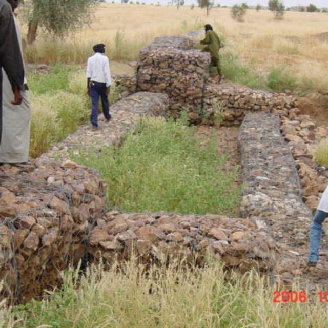
Spillway of a permeable rock dam with stilling basin (PGRNG Mauritanie, GIZ)
Classificação da Tecnologia
Objetivo principal
-
Melhora a produção
-
Reduz, previne, recupera a degradação do solo
-
Preserva ecossistema
-
Protege uma bacia/zonas a jusante – em combinação com outra tecnologia
-
Preservar/melhorar a biodiversidade
-
Reduzir riscos de desastre
-
Adaptar a mudanças climáticas/extremos e seus impactos
-
Atenuar a mudanças climáticas e seus impactos
-
Criar impacto econômico benéfico
-
Cria impacto social benéfico
Uso da terra
Uso do solo misturado dentro da mesma unidade de terra: Sim - Agropecuária (incl. agricultura e pecuária)
-
Terra de cultivo
Número de estações de cultivo por ano: 1
Abastecimento de água
-
Precipitação natural
-
Misto de precipitação natural-irrigado
-
Irrigação completa
Objetivo relacionado à degradação da terra
-
Prevenir degradação do solo
-
Reduzir a degradação do solo
-
Recuperar/reabilitar solo severamente degradado
-
Adaptar à degradação do solo
-
Não aplicável
Degradação abordada
-
Erosão do solo pela água - Wt: Perda do solo superficial/erosão de superfície, Wg: Erosão por ravinas/ravinamento, Wc: erosão costeira
-
Deteriorização química do solo - Cn: declínio de fertilidade e teor reduzido de matéria orgânica (não causado pela erosão)
-
Degradação biológica - Bc: redução da cobertura vegetal
-
Degradação da água - Ha: aridificação, Hg: mudança no lençol freático/aquífero
Grupo de GST
-
Medidas de curva de nível
-
Desvio e drenagem de água
-
Gestão de água de superfície (nascente, rio, lagos, mar)
Medidas de GST
-
Medidas estruturais - S5: Represa, bacia, lago
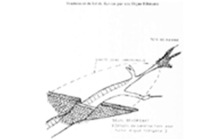
Desenho técnico
Especificações técnicas
Permeable rock dam with spillway
Technical knowledge required for field staff / advisors: moderate
Technical knowledge required for land users: low
Main technical functions: control of dispersed runoff: retain / trap, control of dispersed runoff: impede / retard, control of concentrated runoff: retain / trap, control of concentrated runoff: impede / retard, control of concentrated runoff: drain / divert, stabilisation of soil (eg by tree roots against land slides), increase in nutrient availability (supply, recycling,…), increase of infiltration, increase / maintain water stored in soil, increase of groundwater level / recharge of groundwater, water harvesting / increase water supply, sediment retention / trapping, sediment harvesting
Dam/ pan/ pond
Depth of ditches/pits/dams (m): 0.5-3
Width of ditches/pits/dams (m): 9
Author: PATECORE
Estabelecimento e manutenção: atividades, insumos e custos
Cálculo de insumos e custos
- Os custos são calculados:
- Moeda utilizada para o cálculo de custos: n.a.
- Taxa de câmbio (para USD): 1 USD = n.a
- Custo salarial médio da mão-de-obra contratada por dia: n.a
Fatores mais importantes que afetam os custos
The size of a permeable rock dam can vary considerably from one site to another. The cost is also affected by the distance of the site from the quarry, the topography of the terrain and the actual amount of rock carried in each lorryload. The use of gabions also increases the cost considerably.
cost items:
- Topographical surveying
- supply of quarry rock/stones: 113 m3 per 100 linear metres.
- Labour: depends on the size of the dam.
- Transportation by lorry: 23 lorryloads (skip loader – 4.5 m3 per load).
Other costs: Equipment (pickaxes, shovels, wheelbarrows, water-tube level, etc.).
Atividades de implantação
n.a.
Atividades de manutenção
n.a.
Ambiente natural
Média pluviométrica anual
-
<250 mm
-
251-500 mm
-
501-750 mm
-
751-1.000 mm
-
1.001-1.500 mm
-
1.501-2.000 mm
-
2.001-3.000 mm
-
3.001-4.000 mm
-
> 4.000 mm
Zona agroclimática
-
úmido
-
Subúmido
-
Semiárido
-
Árido
Especificações sobre o clima
Thermal climate class: subtropics
Inclinação
-
Plano (0-2%)
-
Suave ondulado (3-5%)
-
Ondulado (6-10%)
-
Moderadamente ondulado (11-15%)
-
Forte ondulado (16-30%)
-
Montanhoso (31-60%)
-
Escarpado (>60%)
Formas de relevo
-
Planalto/planície
-
Cumes
-
Encosta de serra
-
Encosta de morro
-
Sopés
-
Fundos de vale
Altitude
-
0-100 m s.n.m.
-
101-500 m s.n.m.
-
501-1.000 m s.n.m.
-
1.001-1.500 m s.n.m.
-
1.501-2.000 m s.n.m.
-
2.001-2.500 m s.n.m.
-
2.501-3.000 m s.n.m.
-
3.001-4.000 m s.n.m.
-
> 4.000 m s.n.m.
A tecnologia é aplicada em
-
Posições convexas
-
Posições côncavas
-
Não relevante
Profundidade do solo
-
Muito raso (0-20 cm)
-
Raso (21-50 cm)
-
Moderadamente profundo (51-80 cm)
-
Profundo (81-120 cm)
-
Muito profundo (>120 cm)
Textura do solo (superficial)
-
Grosso/fino (arenoso)
-
Médio (limoso, siltoso)
-
Fino/pesado (argila)
Textura do solo (>20 cm abaixo da superfície)
-
Grosso/fino (arenoso)
-
Médio (limoso, siltoso)
-
Fino/pesado (argila)
Teor de matéria orgânica do solo superior
-
Alto (>3%)
-
Médio (1-3%)
-
Baixo (<1%)
Lençol freático
-
Na superfície
-
< 5 m
-
5-50 m
-
> 50 m
Disponibilidade de água de superfície
-
Excesso
-
Bom
-
Médio
-
Precário/nenhum
Qualidade da água (não tratada)
-
Água potável boa
-
Água potável precária (tratamento necessário)
-
apenas para uso agrícola (irrigação)
-
Inutilizável
A qualidade da água refere-se a:
A salinidade é um problema?
Ocorrência de enchentes
Características dos usuários da terra que utilizam a tecnologia
Orientação de mercado
-
Subsistência (autoabastecimento)
-
misto (subsistência/comercial)
-
Comercial/mercado
Rendimento não agrícola
-
Menos de 10% de toda renda
-
10-50% de toda renda
-
>50% de toda renda
Nível relativo de riqueza
-
Muito pobre
-
Pobre
-
Média
-
Rico
-
Muito rico
Nível de mecanização
-
Trabalho manual
-
Tração animal
-
Mecanizado/motorizado
Sedentário ou nômade
-
Sedentário
-
Semi-nômade
-
Nômade
Indivíduos ou grupos
-
Indivíduo/unidade familiar
-
Grupos/comunidade
-
Cooperativa
-
Empregado (empresa, governo)
Idade
-
Crianças
-
Jovens
-
meia-idade
-
idosos
Área utilizada por residência
-
< 0,5 ha
-
0,5-1 ha
-
1-2 ha
-
2-5 ha
-
5-15 ha
-
15-50 ha
-
50-100 ha
-
100-500 ha
-
500-1.000 ha
-
1.000-10.000 ha
-
> 10.000 ha
Escala
-
Pequena escala
-
Média escala
-
Grande escala
Propriedade da terra
-
Estado
-
Empresa
-
Comunitário/rural
-
Grupo
-
Indivíduo, não intitulado
-
Indivíduo, intitulado
Direitos do uso da terra
-
Acesso livre (não organizado)
-
Comunitário (organizado)
-
Arrendado
-
Indivíduo
Direitos do uso da água
-
Acesso livre (não organizado)
-
Comunitário (organizado)
-
Arrendado
-
Indivíduo
Acesso a serviços e infraestrutura
Emprego (p. ex. não agrícola)
Água potável e saneamento
Impactos
Impactos socioeconômicos
Área de produção (nova terra sob cultivo/uso)
Impactos socioculturais
Segurança alimentar/auto-suficiência
Conhecimento de GST/ degradação da terra
Impactos ecológicos
Colheita/recolhimento de água (escoamento, orvalho, neve, etc)
Ciclo e recarga de nutrientes
Impactos fora do local
Cheias de jusante (indesejada)
Análise do custo-benefício
Benefícios em relação aos custos de estabelecimento
Retornos a curto prazo
muito negativo
muito positivo
Retornos a longo prazo
muito negativo
muito positivo
Benefícios em relação aos custos de manutenção
Retornos a curto prazo
muito negativo
muito positivo
Retornos a longo prazo
muito negativo
muito positivo
Mudança climática
Mudança climática gradual
Temperatura anual aumento
não bem em absoluto
muito bem
Extremos (desastres) relacionados ao clima
não bem em absoluto
muito bem
Tempestade de vento local
não bem em absoluto
muito bem
não bem em absoluto
muito bem
não bem em absoluto
muito bem
Outras consequências relacionadas ao clima
Período de crescimento reduzido
não bem em absoluto
muito bem
Adoção e adaptação
Porcentagem de usuários de terras na área que adotaram a Tecnologia
-
casos isolados/experimental
-
1-10%
-
11-50%
-
> 50%
De todos aqueles que adotaram a Tecnologia, quantos o fizeram sem receber incentivos materiais?
-
0-10%
-
11-50%
-
51-90%
-
91-100%
A tecnologia foi recentemente modificada para adaptar-se as condições variáveis?
A quais condições de mudança?
-
Mudança climática/extremo
-
Mercados dinâmicos
-
Disponibilidade de mão-de-obra (p. ex. devido à migração)
Conclusões e experiências adquiridas
Pontos fortes: visão do usuário de terra
Pontos fortes: a visão do/a compilador/a ou de outra pessoa capacitada
-
Permeable rock dams are used to fill in gullies and control water flow. They slow the flow of floodwaters and spread the water over adjacent land. This improves infiltration, and sediment builds up behind the dams. In time, the sediment fills in the gully which favours the establishment of natural vegetation along it, which helps to stabilise the dam. Seeds are also trapped, favouring the spontaneous growth of grass and trees upstream and downstream, which contributes to restoring and conserving biodiversity.
-
By dissipating floodwater flow, they also contribute to reducing sand filling in valleys further downstream.
-
As these dams are used in valley bottoms and the beds of seasonal streams to increase infiltration, they can also contribute to raising the water table. Such sites are particularly suitable for horticulture and market gardening, which is important in the off-season. The produce supplements the food available and is an extra source of income.
-
increase the area of land that can be used for growing crops
Pontos fracos/desvantagens/riscos: visão do usuário de terracomo superar
Pontos fracos/desvantagens/riscos: a visão do/a compilador/a ou de outra pessoa capacitadacomo superar
-
Depending on the size of the dam, the construction of this type of structure may require a high level of engineering expertise (topographical surveying, calculation of floodwater flow).It also requires a large amount of quarry rocks, which means that the cost of the structure and the labour and transport required is significantly higher than for structures made with stones. As the data required for calculating floodwater flow is often unavailable, the dams must be observed during the first few years, so that they can be reinforced and repaired if necessary.
It is important for farmers to have access to partners providing the necessary know-how, means of transport and support for community organisation. The community must be trained to carry out repair work.
Referências
Revisor
-
Alexandra Gavilano
-
Fabian Ottiger
-
Joana Eichenberger
Data da documentação: 25 de Setembro de 2014
Última atualização: 18 de Novembro de 2022
Pessoas capacitadas
-
Dieter Nill - Especialista em GST
-
Sabine Dorlöchter-Sulser - Especialista em GST
-
Mamadou Abdou Sani - Especialista em GST
Descrição completa no banco de dados do WOCAT
A documentação foi facilitada por
Instituição
- Deutsche Gesellschaft für Internationale Zusammenarbeit (GIZ) GmbH (GIZ) - Alemanha
- Misereor - Alemanha
Projeto
- Manual of Good Practices in Small Scale Irrigation in the Sahel (GIZ )
Links para informação relevante que está disponível online
- Good Practices in Soil and Water Conservation. A contribution to adaptation and farmers´ resilience towards climate change in the Sahel. Published by GIZ in 2012.: http://agriwaterpedia.info/wiki/Main_Page


