Sub-Sarface Dams (SSD) [Quênia]
- Criação:
- Atualização:
- Compilador/a: Guyo Roba
- Editor: –
- Revisores: Rima Mekdaschi Studer, Donia Mühlematter
technologies_3340 - Quênia
- Resumo completo em PDF
- Resumo completo em PDF para impressão
- Resumo completo no navegador
- Resumo completo (sem formatação)
- Sub-Sarface Dams (SSD): 22 de Junho de 2018 (inactive)
- Sub-Sarface Dams (SSD): 7 de Maio de 2018 (inactive)
- Sub-Sarface Dams (SSD): 17 de Julho de 2018 (inactive)
- Sub-Sarface Dams (SSD): 15 de Agosto de 2018 (inactive)
- Sub-Surface Dams (SSD): 5 de Dezembro de 2018 (inactive)
- Sub-Sarface Dams (SSD): 3 de Setembro de 2018 (inactive)
- Sub-Surface Dams (SSD): 2 de Novembro de 2021 (public)
Veja as seções
Expandir tudo Recolher tudo1. Informação geral
1.3 Condições em relação ao uso da informação documentada através de WOCAT
Quando os dados foram compilados (no campo)?
11/01/2018
O/a compilador/a e a(s) pessoa(s) capacitada(s) aceitam as condições relativas ao uso de dados documentados através da WOCAT:
Sim
1.4 Declaração de sustentabilidade da tecnologia descrita
A tecnologia descrita aqui é problemática em relação a degradação da terra de forma que não pode ser declarada uma tecnologia de gestão sustentável de terra?
Não
2. Descrição da tecnologia de GST
2.1 Descrição curta da tecnologia
Definição da tecnologia:
These are constructions stretching across the sand filled dry riverbed, down towards the impermeable floor of the riverbed. They are totally submerged into the ground. For example by fully covering after construction by sand. This are done along dry rivers with huge sand deposits, which has high yield potential and where water can be easily extracted. The aim is to raise groundwater tables and increase the storage capacity for water withdrawals.
2.2 Descrição detalhada da tecnologia
Descrição:
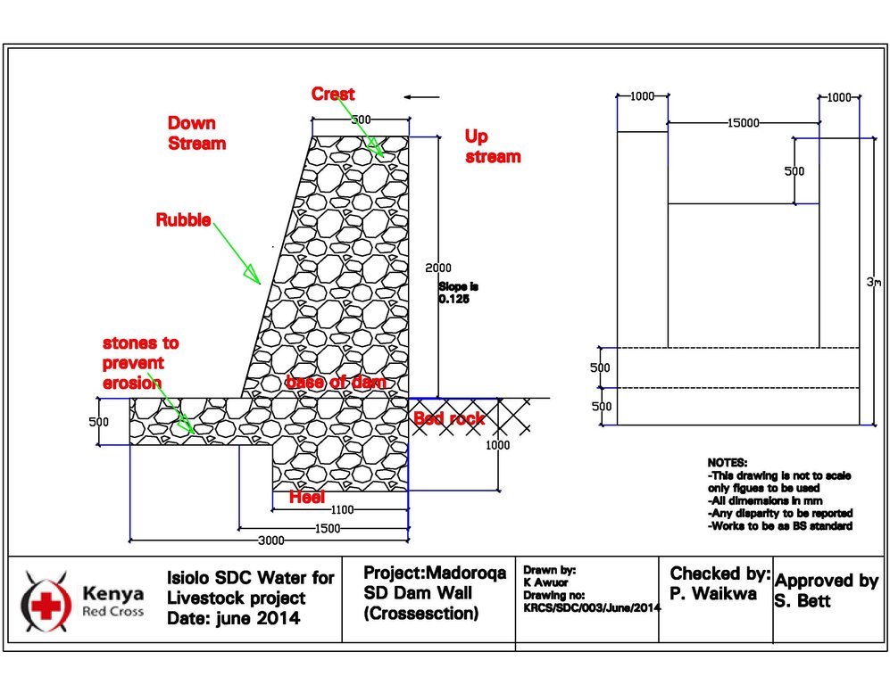
The technology is applied in northern rangeland of Isiolo County which is managed under communal management systems. The aim of technology to reduce pasture and water availability imbalances. The dimensions of sub-surface dam include: a length of water spread (103m),width of the dam (15m), width of water spread (18m), effective dam height (2m), volume of retained sand (103 x 0.5(15 +18) x0.5 x2.0 = 5098.50m3) and the volume of water that can be abstracted from the sand bed (25/100x 5098.50m3 = 1274.6.36m3).
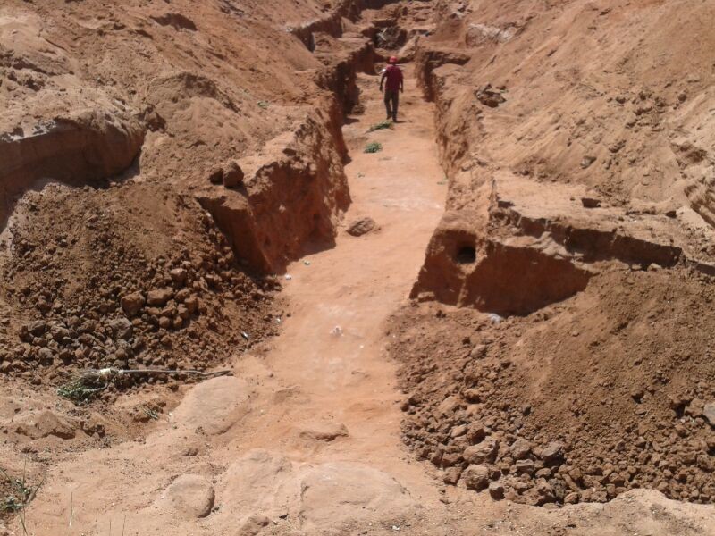
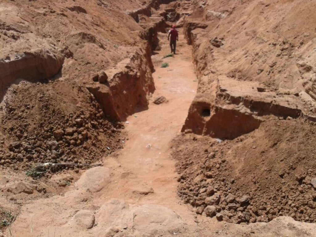
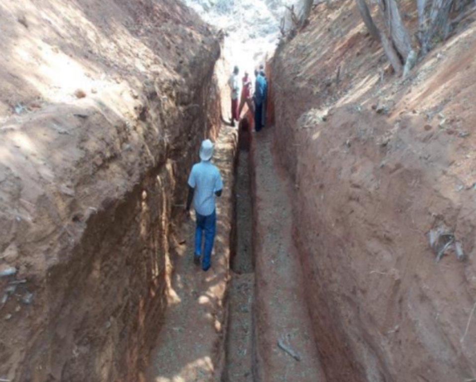
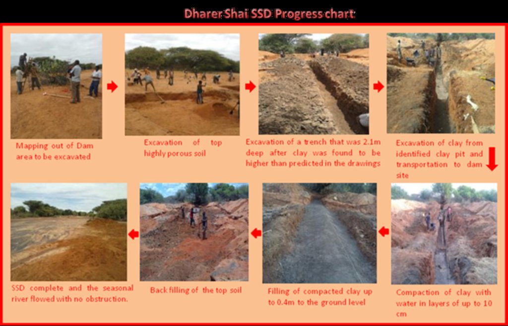
The technology functions as underground water storage infrastructure and the typical activities include, excavation of top porous soil, excavation of sample pits within the excavated area, checking filtration rates of soil, compaction of soil on which dam liners are laid, smoothing the sharp liners along which the dam liners are laid, making grooves to anchor the dam liner, laying the dam liner, anchoring the dam liner with a mixture of cement, water proof and sand with water (motor) and finally drying of the motor and filling back of sand.
The development of Sub-Surface Dams (SSDs) was done through Cash for Work program where local labours comprising of 40-50 persons are engaged in excavation, compactions and developing the liners. Farm tools like jembe, panga, spades and human labour are required to develop the SSD. The technology improves water supply/availability, thereby extending the period of livestock grazing in areas where typically water is depleted before the pasture hence improves water access for livestock in ways that support wider management and utilization of the rangeland and as such strength the resilience of pastoralists to droughts. This effectively gives pastoral groups, an extra grazing time (typically 2 extra months), a period usually not too long to encourage land degradation through over-grazing but long enough to enable pastoralist utilize the remaining pasture in wet season grazing areas. In so doing, the technology enable balanced use of vast communal lands without livestock retreating to dry season grazing areas.
In the process of the landscape level participatory planning with the communities: i) they identified different challenges, including need for decommissioning certain water points that they consider are contributing to over grazing and also attracting other communities, hence drive frequent conflicts, secondly, ii) they mapped areas in the rangeland where there is mismatch between water and pasture availability, most of these areas are in wet season grazing areas. So the next discussion was on what strategic water infrastructures that will enable herders to graze for 2 -3 extra months to enable them utilize the grass before they migrate to the traditional dry season grazing areas. So by design, the technology should only yield water that can allow settling for those extra months, not longer to the detriment of the rangeland
The technology was instrumental in fostering both balanced utilization of land and strengthening sustainable use of the vast rangeland by ensuring that herders utilize available pastures in the wet seasons grazing areas before moving to dry seasons grazing areas. The water stored through the technology stays longer, in this case study, the water lasted for 5 months after the end of the rainy season .
The area receives bimodal rainfall, long rain in March-May and short rain in November-December. With changing seasons/climate, the dry seasons can last up to 1 year in case of rainfall failure. Typically, dry seasons are 6-7 months (May- November).
Normally, the water is depleted within 2 months after the rainy period. The technology is also cheap and easy to understand and construct (especially in areas with clay as the underlying impermeable material) with a possibility of the communities to be taught how to identify suitable site and the entire process of construction. However, in areas without clay soil, the excavation of clay and transportation can be labour intensive and expensive.
2.3 Fotos da tecnologia
2.5 País/região/locais onde a tecnologia foi aplicada e que estão cobertos nesta avaliação
País:
Quênia
Região/Estado/Província:
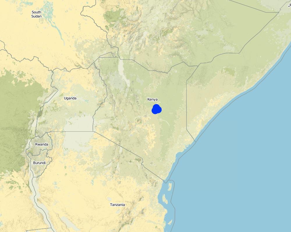
Northern Kenya
Especificação adicional de localização:
Garba Tula, Isiolo County
Map
×2.7 Introdução da tecnologia
Especifique como a tecnologia foi introduzida:
- através de projetos/intervenções externas
3. Classificação da tecnologia de GST
3.1 Principal/principais finalidade(s) da tecnologia
- Melhora a produção
- Reduz, previne, recupera a degradação do solo
- Adaptar a mudanças climáticas/extremos e seus impactos
- Atenuar a mudanças climáticas e seus impactos
- Criar impacto econômico benéfico
- Cria impacto social benéfico
3.2 Tipo(s) atualizado(s) de uso da terra onde a tecnologia foi aplicada

Pastagem
Pastagem extensiva:
- Seminomadismo/pastoralismo
Comentários:
Communal grazing area that is shared by 2 and more pastoral groups
3.3 Mais informações sobre o uso da terra
Abastecimento de água para a terra na qual a tecnologia é aplicada:
- Precipitação natural
Densidade animal (se relevante):
Fluctuates, depending on seasons and pasture availability
3.4 Grupo de GST ao qual pertence a tecnologia
- Gestão de pastoralismo e pastagem
3.5 Difusão da tecnologia
Especifique a difusão da tecnologia:
- Aplicado em pontos específicos/concentrado numa pequena área
Comentários:
Sub-Surface Dams are only suitable in areas along the river, with suitable density of sand deposits
3.6 Medidas de GST contendo a tecnologia

Medidas estruturais
- S5: Represa, bacia, lago
3.7 Principais tipos de degradação da terra abordados pela tecnologia

Outro
Comentários:
Mismatch of pasture and water resources - there are areas where pastures are plenty but surface rain water is depleted earlier than pasture.
3.8 Redução, prevenção ou recuperação da degradação do solo
Especifique o objetivo da tecnologia em relação a degradação da terra:
- Prevenir degradação do solo
- Reduzir a degradação do solo
Comentários:
The SSD technology increase water availability is period immediately after the rain, hence ensuring better pasture utilization and more sustainable use of land.
4. Especificações técnicas, implementação de atividades, entradas e custos
4.1 Desenho técnico da tecnologia
4.2 Especificações técnicas/ explicações do desenho técnico
The SSD has initial excavation works. The construction of the SSD was constructed by 50 laborers. The area of excavation is subdivided into 45 square chambers of 4X2.3X2.2= 20.2M3 (not to scale). Each of the chambers were excavated by 5 laborers. The estimated time for excavation as per the plan was estimated to be five days. Excavation and transportation of the clay from the clay pit was estimated to take an approximate of five days while the compacting of the clay will follow one week later, and laying out of the concrete and refilling of the sand for another week. The liner will then be finally placed. In summary, the excavation of sand takes 5 days, and the excavation of clay soil takes another 5 days while concrete placing, compacting of clay as well as putting of liner and refilling of sand takes 10 days.
4.3 Informação geral em relação ao cálculo de entradas e custos
Especifique como custos e entradas foram calculados:
- Por unidade de tecnologia
Especifique a unidade:
chamber
Especifique a moeda utilizada para os cálculos de custo:
- Dólares norte-americanos
Indique a média salarial da mão-de-obra contratada por dia:
3.5 USD per day
4.4 Atividades de implantação
| Atividade | Tipo de medida | Periodicidade | |
|---|---|---|---|
| 1. | Removing sand over dyke and man-days for excavating and transporting soil to dam site | Outras medidas | 21 days for 45 casual labourers |
| 2. | Building and compaction soil in dam wall | Estrutural | 3 days for 45 casual labourers |
| 3. | Supplying water for compaction | Outras medidas | 0.5 day for 45 casual labourers |
| 4. | Back-filling sand on dam | Outras medidas | 1 day for 45 casual labourers |
| 5. | Supplying water for compacting clay in dam wall | Outras medidas | 2 days for 45 casual labourers |
| 6. | Compacting soil and placing liners | Outras medidas | 12 days for 45 casual labourers |
Comentários:
The construction of SSD was done through “Cash for work” which is participatory process that involves community mobilization, identification of beneficiaries and formation of “Cash for work” committees, registrations and verification of beneficiaries and implementation/supervision of the work.
4.5 Custos e entradas necessárias para a implantação
| Especifique a entrada | Unidade | Quantidade | Custos por unidade | Custos totais por entrada | % dos custos arcados pelos usuários da terra | |
|---|---|---|---|---|---|---|
| Mão-de-obra | tools - jembe, spade etc. | pieces | 80,0 | 5,33 | 426,4 | |
| Mão-de-obra | Removing sand over dyke and Man-days for excavating and transporting soil to dam site | per day | 945,0 | 4,0 | 3780,0 | |
| Mão-de-obra | Building and compaction soil in dam wall | per day | 135,0 | 4,0 | 540,0 | |
| Equipamento | Supplying water for compaction | per day | 22,5 | 4,0 | 90,0 | |
| Equipamento | Back-filling sand on dam | per day | 45,0 | 4,0 | 180,0 | |
| Equipamento | Supplying water for compacting soil in dam wall | per day | 90,0 | 4,0 | 360,0 | |
| Equipamento | Compacting soil and placing liners | per day | 540,0 | 4,0 | 2160,0 | |
| Custos totais para a implantação da tecnologia | 7536,4 | |||||
Comentários:
As stated, the cash for work approach means that people get paid 4 USD per day for working on SSD until completion. There are phases where people participated in preliminary phases in meetings and consultation without payments but the actual work was done on cash for work basis.
4.6 Atividades recorrentes/manutenção
| Atividade | Tipo de medida | Periodicidade/frequência | |
|---|---|---|---|
| 1. | Training of communities to manage and maintain the structures | Estrutural | yearly |
4.7 Custos e entradas necessárias pata a manutenção/atividades recorrentes (por ano)
| Especifique a entrada | Unidade | Quantidade | Custos por unidade | Custos totais por entrada | % dos custos arcados pelos usuários da terra | |
|---|---|---|---|---|---|---|
| Mão-de-obra | Labour for site protection and maintenance of hygiene | per site | 10,0 | 100,0 | 1000,0 | |
| Custos totais para a manutenção da tecnologia | 1000,0 | |||||
Comentários:
Water User Associations on the sites are trained on the management of the structures on behalf of the community e.g. on the protection of structure and hygiene maintenance.
4.8 Fatores mais importantes que afetam os custos
Descreva os fatores mais determinantes que afetam os custos:
Distance of the sub-surface dam from villages, extent of destruction by floods and human activities
5. Ambiente natural e humano
5.1 Clima
Precipitação pluviométrica anual
- <250 mm
- 251-500 mm
- 501-750 mm
- 751-1.000 mm
- 1.001-1.500 mm
- 1.501-2.000 mm
- 2.001-3.000 mm
- 3.001-4.000 mm
- > 4.000 mm
Especificações/comentários sobre a pluviosidade:
because of the climate change, the rainfall is becoming more erratic.
Indique o nome da estação meteorológica de referência considerada:
Isiolo
Zona agroclimática
- Semiárido
5.2 Topografia
Declividade média:
- Plano (0-2%)
- Suave ondulado (3-5%)
- Ondulado (6-10%)
- Moderadamente ondulado (11-15%)
- Forte ondulado (16-30%)
- Montanhoso (31-60%)
- Escarpado (>60%)
Formas de relevo:
- Planalto/planície
- Cumes
- Encosta de serra
- Encosta de morro
- Sopés
- Fundos de vale
Zona de altitude:
- 0-100 m s.n.m.
- 101-500 m s.n.m.
- 501-1.000 m s.n.m.
- 1.001-1.500 m s.n.m.
- 1.501-2.000 m s.n.m.
- 2.001-2.500 m s.n.m.
- 2.501-3.000 m s.n.m.
- 3.001-4.000 m s.n.m.
- > 4.000 m s.n.m.
Indique se a tecnologia é aplicada especificamente em:
- Posições côncavas
5.3 Solos
Profundidade do solo em média:
- Muito raso (0-20 cm)
- Raso (21-50 cm)
- Moderadamente profundo (51-80 cm)
- Profundo (81-120 cm)
- Muito profundo (>120 cm)
Textura do solo (solo superficial):
- Grosso/fino (arenoso)
Textura do solo (>20 cm abaixo da superfície):
- Grosso/fino (arenoso)
Matéria orgânica do solo superficial:
- Médio (1-3%)
5.4 Disponibilidade e qualidade de água
Lençol freático:
5-50 m
Disponibilidade de água de superfície:
Precário/nenhum
Qualidade da água (não tratada):
Água potável boa
A salinidade da água é um problema?
Não
Ocorre inundação da área?
Não
5.5 Biodiversidade
Diversidade de espécies:
- Alto
Diversidade de habitat:
- Alto
5.6 Características dos usuários da terra que utilizam a tecnologia
Sedentário ou nômade:
- Semi-nômade
Orientação de mercado do sistema de produção:
- Misto (subsistência/comercial)
Rendimento não agrícola:
- Menos de 10% de toda renda
Nível relativo de riqueza:
- Média
Indivíduos ou grupos:
- Grupos/comunidade
Nível de mecanização:
- Trabalho manual
Gênero:
- Homens
Idade dos usuários da terra:
- meia-idade
5.7 Média da área de terra própria ou arrendada por usuários da terra que utilizam a tecnologia
- < 0,5 ha
- 0,5-1 ha
- 1-2 ha
- 2-5 ha
- 5-15 ha
- 15-50 ha
- 50-100 ha
- 100-500 ha
- 500-1.000 ha
- 1.000-10.000 ha
- > 10.000 ha
É considerado pequena, média ou grande escala (referente ao contexto local)?
- Grande escala
5.8 Propriedade de terra, direitos de uso da terra e de uso da água
Propriedade da terra:
- Comunitário/rural
Direitos do uso da terra:
- Comunitário (organizado)
Direitos do uso da água:
- Comunitário (organizado)
5.9 Acesso a serviços e infraestrutura
Saúde:
- Pobre
- Moderado
- Bom
Educação:
- Pobre
- Moderado
- Bom
Assistência técnica:
- Pobre
- Moderado
- Bom
Emprego (p. ex. não agrícola):
- Pobre
- Moderado
- Bom
Mercados:
- Pobre
- Moderado
- Bom
Energia:
- Pobre
- Moderado
- Bom
Vias e transporte:
- Pobre
- Moderado
- Bom
Água potável e saneamento:
- Pobre
- Moderado
- Bom
Serviços financeiros:
- Pobre
- Moderado
- Bom
6. Impactos e declarações finais
6.1 Impactos no local mostrados pela tecnologia
Impactos socioeconômicos
Produção
Produção animal
Gestão de terra
Disponibilidade e qualidade de água
Disponibilidade de água para criação de animais
Impactos ecológicos
Clima e redução de riscos de desastre
Impactos da seca
6.2 Impactos externos mostrados pela tecnologia
Disponibilidade de água
6.3 Exposição e sensibilidade da tecnologia às mudanças climáticas graduais e extremos/desastres relacionados ao clima (conforme o ponto de vista dos usuários da terra)
Extremos (desastres) relacionados ao clima
Desastres climatológicos
| Como a tecnologia lida com isso? | |
|---|---|
| Seca | bem |
Desastres hidrológicos
| Como a tecnologia lida com isso? | |
|---|---|
| Inundação geral (rio) | bem |
Comentários:
The technology copes very well with floods as the construction is embedded in the sand and thus very well protected.
6.4 Análise do custo-benefício
Como os benefícios se comparam aos custos de implantação (do ponto de vista dos usuários da terra)?
Retornos a curto prazo:
positivo
Retornos a longo prazo:
positivo
Como os benefícios se comparam aos custos recorrentes/de manutenção(do ponto de vista dos usuários da terra)?
Retornos a curto prazo:
positivo
Retornos a longo prazo:
muito positivo
Comentários:
The technology has limited running and maintenance costs once its done fairly well.
6.5 Adoção da tecnologia
- 1-10%
Entre todos aqueles que adotaram a tecnologia, quantos adotaram espontaneamente, ou seja, sem receber nenhum incentivo material/pagamentos?
- 0-10%
6.6 Adaptação
A tecnologia foi recentemente modificada para adaptar-se as condições variáveis?
Não
6.7 Pontos fortes/vantagens/oportunidades da tecnologia
| Pontos fortes/vantagens/oportunidades na visão do usuário da terra |
|---|
| The technology created opportunity to graze in wet season grazing areas for an averge extra 2 months period after rainy seasons. The technology has provided additional water that gave herders extra days to graze in wet season areas and utilize the pasture that would have been unutilized due to water constrains. In so doing, the land users utilized the pasture without retreating to traditional dry season grazing areas. |
| The extra grazing months has reduced overall livestock mortality during droughts and also improved resilience of pastoral community. |
| The distance travelled and effort required to access water was reduced. Community members reported reduced distances covered and time spent in search of water for livestock. In some instances the distance reduced from 12-15 Km to 3 Km. Community members also mentioned reduction in conflict incidences over water resources in some areas due to adequate supply of water as a result of construction of water infrastructure. |
| The balanced utilization of the grazing area through SSD water provision, enables herd to graze in wet season grazing for slightly longer period and utilize pasture optimally, this however, does not mean that during that garzing period, there will be overgrazing. The volume of water available restricts the number of animals sustained by the grazing area. |
| Pontos fortes/vantagens/oportunidades na visão do/a compilador/a ou de outra pessoa capacitada |
|---|
| The technology has created an opportunity to optimally use the grazing area and overall reduced land degradation. The technology Improves access to water for livestock in ways which promote more sustainable management of rangeland resources and as such strengthening the resilience of local communities. |
| The validation process prior to construction of the SSD is draws critical lessons of identifying and agreeing on where to construct the SSD in a way that fit within broader sustainable rangeland management in a manner that ensured sustainable and efficient utilization of pasture and browse resources in targeted areas. The increase in water supply allowed livestock to graze additional 2-3 months in target areas before shifting to dry grazing areas where previously they migrated before exhausting the pasture and browse resources due to water scarcity. The dry season grazing area is towards Merti, in Kom and Sabarwawa where there are deep boreholes, under, lock and key and only opened during dry seasons. In typical year, the dry season period is about 7 months. But when one rain season fail it goes to about 11 months. |
6.8 Pontos fracos, desvantagens/riscos da tecnologia e formas de superá-los
| Pontos fracos/desvantagens/riscos na visão do usuário da terra | Como eles podem ser superados? |
|---|---|
| When the construction season for SSD is not well planned, there is likelihood/risks of the dams being washed away by flash floods. | Better planning and timing of the development of SDD, just slightly before the onset of rainfall. |
7. Referências e links
7.1 Métodos/fontes de informação
- compilação de relatórios e outra documentação existente
7.3 Links para informação relevante que está disponível online
Título/ descrição:
Promoting resilience by influencing water infrastructure development in community managed rangelands of Kenya
URL:
https://portals.iucn.org/library/sites/library/files/documents/2014-088.pdf
Título/ descrição:
Balancing water infrastructure in community-managed rangelands in the arid and semi-arid lands of Kenya
URL:
https://portals.iucn.org/library/sites/library/files/documents/2014-089.pdf
Links e módulos
Expandir tudo Recolher tudoLinks
Não há links
Módulos
Não há módulos


