Earth checks for Gully reclamation [Etiópia]
- Criação:
- Atualização:
- Compilador/a: Daniel Danano
- Editor: –
- Revisores: Fabian Ottiger, Alexandra Gavilano
technologies_1069 - Etiópia
Veja as seções
Expandir tudo Recolher tudo1. Informação geral
1.2 Detalhes do contato das pessoas capacitadas e instituições envolvidas na avaliação e documentação da tecnologia
Especialista em GST:
Estifanos Zena
Ministry of Agriculture and Rural Development
Etiópia
Especialista em GST:
Desta Hiwot
Boditi, Department of Agriculture and Rural Development
Etiópia
Nome da(s) instituição(ões) que facilitou(ram) a documentação/ avaliação da Tecnologia (se relevante)
FAO Food and Agriculture Organization (FAO Food and Agriculture Organization) - ItáliaNome da(s) instituição(ões) que facilitou(ram) a documentação/ avaliação da Tecnologia (se relevante)
Ministry of Agriculture and Rural Development (Ministry of Agriculture and Rural Development) - Etiópia1.3 Condições em relação ao uso da informação documentada através de WOCAT
O compilador e a(s) pessoa(s) capacitada(s) aceitam as condições relativas ao uso de dados documentados através do WOCAT:
Sim
2. Descrição da tecnologia de GST
2.1 Descrição curta da tecnologia
Definição da tecnologia:
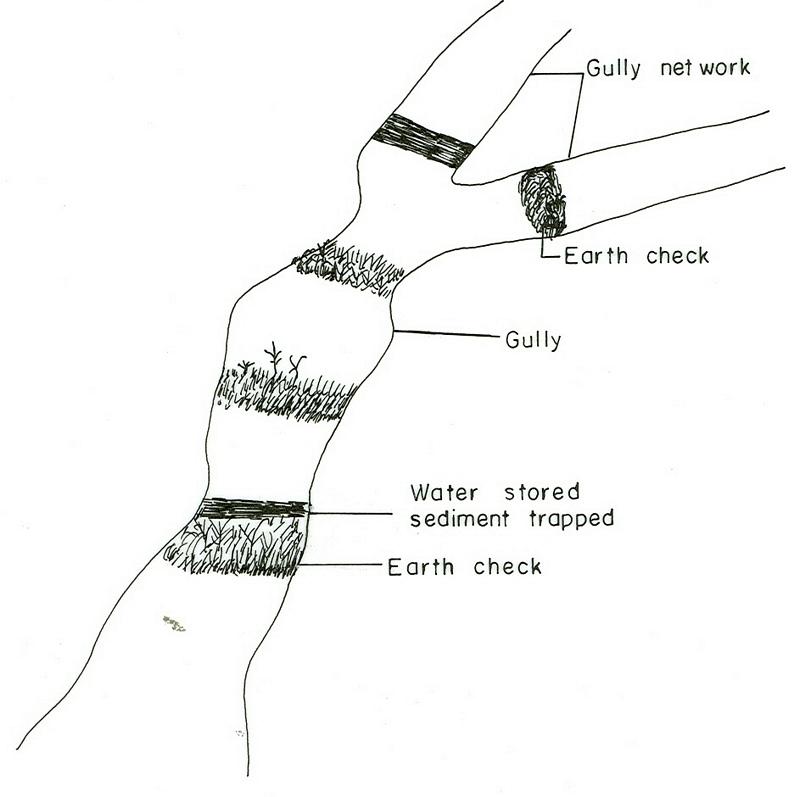
Earh-checks are constructed of earth embankment put across in a deep gully in such a way to trap sediment and store water passing by it.
2.2 Descrição detalhada da tecnologia
Descrição:
Active deep gullies are plugged by digging earth from the bottom as well as gully sides and embanked forming a barrier to runoff passing through it. The embankment is reinforced by planting useful plants such as banana, sesbania, gravillea, gesho, etc., The purpose is to rehabilitate gullies having depth and expand along sides and towards the head. By constructing earth checks the water is stored in the checks. The water percolates down the ground enriching the ground water. The soil is trapped in the checks and later brings up the gully gradient higher. As a result, a cultivable/cropable strip is formed. Weeding and cultivation done to plants established.The gully fence and breaks are repaired. The technology is seen to be suitable to humid highlands where land loss by gully is a serious problem and land under cultivation and grazing is getting here and there. In brief it is suitable in areas where land degradation problem is increasing with currently cultivated and grazed lands are encroched by gully expansion.
2.3 Fotos da tecnologia
Galeria de Mídias
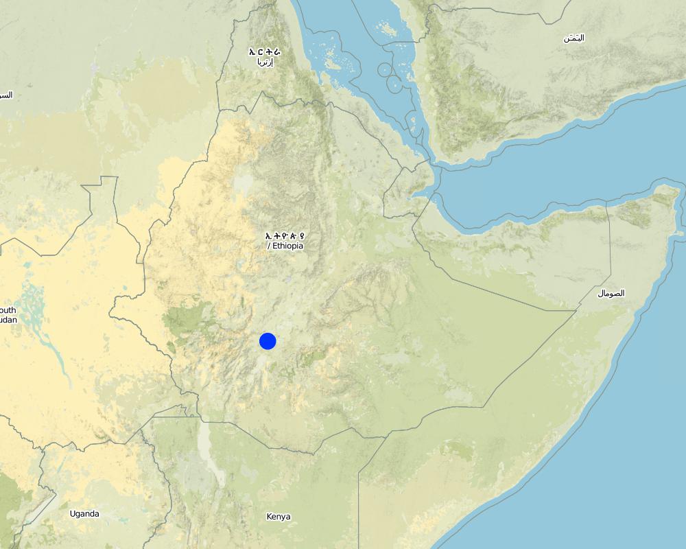
2.5 País/região/locais onde a tecnologia foi aplicada e que estão cobertos nesta avaliação
País:
Etiópia
Região/Estado/Província:
SNNPR
Especificação adicional de localização:
SNNPR/Damot Galle/Bilate
Comentários:
Total area covered by the SLM Technology is 51.2 km2.
Map
×2.6 Data da implementação
Caso o ano exato seja desconhecido, indique a data aproximada:
- menos de 10 anos atrás (recentemente)
2.7 Introdução da tecnologia
Especifique como a tecnologia foi introduzida:
- através de projetos/intervenções externas
Comentários (tipos de projeto, etc.):
The technology is introduced but highly modified by adjesting design, layout and by increasing use of locally available materials for construction.
3. Classificação da tecnologia de GST
3.1 Principal/principais finalidade(s) da tecnologia
- Reduz, previne, recupera a degradação do solo
3.2 Tipo(s) atualizado(s) de uso da terra onde a tecnologia foi aplicada
Uso do solo misturado dentro da mesma unidade de terra:
Sim
Especificar o uso misto da terra (culturas/ pastoreio/ árvores):
- Agrossilvipecuária

Terra de cultivo
- Cultura anual
- Cultura perene (não lenhosa)
- Cultura de árvores e arbustos
Cultivo anual - Especificar culturas:
- cereais - milho
- cereais - sorgo
- culturas de raízes/tubos - batata doce, inhame, taro/cocoyam, outros
- culturas de raízes/tubérculos- mandioca
- culturas de raiz/tubérculos- batatas
Cultivo de árvores e arbustos - Especificar culturas:
- abacate
- frutas, outros
- manga, mangostão, goiaba
- mamão
- enset, taro, sugar cane, Leucaena, Sesbania, Grevillea
Número de estações de cultivo por ano:
- 2
Especifique:
Longest growing period in days: 210 Longest growing period from month to month: Apr - Oct Second longest growing period in days: 180 Second longest growing period from month to month: Aug - Jun
O cultivo entre culturas é praticado?
Sim
Em caso afirmativo, especifique quais são as culturas intercultivadas:
maize-sweet potato/haricot bean
O rodízio de culturas é praticado?
Sim
Caso afirmativo, especifique:
maize-tarro-sorghum

Pastagem
Tipo de animal:
- gado - lácteo
- cavalos
- donkeys, oxen

Floresta/bosques
Produtos e serviços:
- Madeira
- Lenha
- Pastagem/Alimentação de folhas e brotos
Comentários:
Major land use problems (compiler’s opinion): Monocropping, soil erosion, fertility mining, overgrazing, improper runoff management.
Grazingland comments: Livestock such as cows, oxen, donkeys and horse are thethered at a very small piece of land left infront of houses usually meant for social purposes. Some farmers thether their animals in a piece of land left uncropped in the field. The most part of livestock feed comes from crop residue which is collected from crop fields. Maize stalk, teff straw and enset leaves are fed stall.
Forest products and services: timber, fuelwood, grazing / browsing
Type of cropping system and major crops comments: Maize-sweet potato-Teff-potato-sorghum
3.4 Abastecimento de água
Abastecimento de água para a terra na qual a tecnologia é aplicada:
- Precipitação natural
3.5 Grupo de GST ao qual pertence a tecnologia
- Medidas de curva de nível
- Coleta de água
3.6 Medidas de GST contendo a tecnologia
3.7 Principais tipos de degradação da terra abordados pela tecnologia

Erosão do solo pela água
- Wt: Perda do solo superficial/erosão de superfície
- Wg: Erosão por ravinas/ravinamento

Deteriorização química do solo
- Cn: declínio de fertilidade e teor reduzido de matéria orgânica (não causado pela erosão)
Comentários:
Main type of degradation addressed: Wt: loss of topsoil / surface erosion, Wg: gully erosion / gullying
Secondary types of degradation addressed: Cn: fertility decline and reduced organic matter content
3.8 Redução, prevenção ou recuperação da degradação do solo
Especifique o objetivo da tecnologia em relação a degradação da terra:
- Prevenir degradação do solo
- Reduzir a degradação do solo
Comentários:
Main goals: Also rehabilitation / reclamation of denuded land
4. Especificações técnicas, implementação de atividades, entradas e custos
4.1 Desenho técnico da tecnologia
Especificações técnicas (relacionada ao desenho técnico):
SNNPR
Technical knowledge required for field staff / advisors: high
Technical knowledge required for land users: moderate
Main technical functions: water harvesting / increase water supply, sediment retention / trapping, sediment harvesting
Secondary technical functions: control of concentrated runoff: retain / trap, reduction of slope angle, reduction of slope length
Early planting
Material/ species: maize
Quantity/ density: 85000/ha
Remarks: sawn in lines
Mixed cropping / intercropping
Material/ species: maize-sweet potato/haricot bean
Remarks: inter cropped & strip cropped
Contour planting / strip cropping
Material/ species: maize-taro-enset
Mulching
Material/ species: enset
Manure / compost / residues
Material/ species: maize, potato, sweet potato, traro
Mineral (inorganic) fertilizers
Material/ species: Teff, maize, sorghum
Rotations / fallows
Material/ species: maize-tarro-sorghum
Remarks: only rotations
Breaking compacted topsoil
Remarks: primary and secondary oxen tillage
Contour tillage
Remarks: tillage done following contour
Agronomic measure: harrowing
Aligned: -contour
Vegetative material: O : other
Vertical interval between rows / strips / blocks (m): 0.2-0.5
Spacing between rows / strips / blocks (m): 2-4
Vertical interval within rows / strips / blocks (m): 0.5-2
Width within rows / strips / blocks (m): 0.5-1
Scattered / dispersed
Vegetative material: T : trees / shrubs
Number of plants per (ha): 4000
Vertical interval between rows / strips / blocks (m): 0.2
Spacing between rows / strips / blocks (m): 1.5x1.5
Vertical interval within rows / strips / blocks (m): 1.5
Width within rows / strips / blocks (m): 1.5
In blocks
Vegetative material: T : trees / shrubs
Number of plants per (ha): 2500
Vertical interval between rows / strips / blocks (m): 0.5
Spacing between rows / strips / blocks (m): 2x2
Vertical interval within rows / strips / blocks (m): 2
Width within rows / strips / blocks (m): 2
Trees/ shrubs species: Leucaena, Sesbania, Grevillea
Fruit trees / shrubs species: Mango, papaya, Avocado
Perennial crops species: Casava
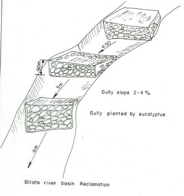
Slope (which determines the spacing indicated above): 10.00%
If the original slope has changed as a result of the Technology, the slope today is (see figure below): 8.00%
Gradient along the rows / strips: 0.00%
Diversion ditch/ drainage
Depth of ditches/pits/dams (m): 0.5
Width of ditches/pits/dams (m): 0.5
Length of ditches/pits/dams (m): 100
Height of bunds/banks/others (m): 0.6
Width of bunds/banks/others (m): 0.5
Length of bunds/banks/others (m): 100
Retention/infiltration ditch/pit, sediment/sand trap
Vertical interval between structures (m): 0.5
Depth of ditches/pits/dams (m): 0.6
Width of ditches/pits/dams (m): 0.7
Length of ditches/pits/dams (m): 4
Height of bunds/banks/others (m): 0.75
Width of bunds/banks/others (m): 0.6
Terrace: backward sloping
Vertical interval between structures (m): 1.5
Spacing between structures (m): 12
Depth of ditches/pits/dams (m): 0.9
Width of ditches/pits/dams (m): 0.5
Length of ditches/pits/dams (m): 50-75
Bund/ bank: level
Vertical interval between structures (m): 1.2
Spacing between structures (m): 10
Depth of ditches/pits/dams (m): 0.6
Width of ditches/pits/dams (m): 0.7
Length of ditches/pits/dams (m): 50-80
Height of bunds/banks/others (m): 0.75
Construction material (earth): Most of the structural measures are made by earth involving excavation and embankment.
Construction material (stone): Stone is mainly used for demonstration.
Slope (which determines the spacing indicated above): 10%
If the original slope has changed as a result of the Technology, the slope today is: 8%
Lateral gradient along the structure: 0%
Vegetation is used for stabilisation of structures.
Change of land use type: The land after treatment is closed
Control / change of species composition: Grazing land changed to plantation and cropping
Other type of management: change of management / intensity level - Grazing land changed to plantation and cropping
4.2 Informação geral em relação ao cálculo de entradas e custos
Outro/moeda nacional (especifique):
Birr
Se for relevante, indique a taxa de câmbio do USD para moeda local (por exemplo, 1 USD = 79,9 Real): 1 USD =:
8,5
Indique a média salarial da mão-de-obra contratada por dia:
0.60
4.3 Atividades de implantação
| Atividade | Periodicidade (estação do ano) | |
|---|---|---|
| 1. | Land preparation | September, october |
| 2. | Sugar cane planting | November |
| 3. | Sugar cane cultivation | January/August |
| 4. | Casava planting | April |
| 5. | Casava cultivation | June |
| 6. | Maize planting | January-1st plough, April 2nd plough |
| 7. | Maize cultivation | June |
| 8. | Sweet potato planting | September |
| 9. | Sweet potato cultivation | October |
| 10. | Fruite trees | June |
| 11. | Digging foundation | November-February |
| 12. | Forming embankment | November-February |
| 13. | Side wall shaping | November-February |
| 14. | Planting trees and shrubs | March-1st planting & June 2nd planting |
| 15. | Excluding animals by fencing and guarding | all year |
| 16. | Construct cutoff drain | dry season |
| 17. | Establish buffer zone between Area enclosure and crop land by strip of plantation | June/July |
| 18. | Construct earth checks and trenches in the gully | dry season |
4.4 Custos e entradas necessárias para a implantação
| Especifique a entrada | Unidade | Quantidade | Custos por unidade | Custos totais por entrada | % dos custos arcados pelos usuários da terra | |
|---|---|---|---|---|---|---|
| Mão-de-obra | Labour | ha | 1,0 | 282,3 | 282,3 | 100,0 |
| Equipamento | Tools | ha | 1,0 | 270,6 | 270,6 | 100,0 |
| Material vegetal | Seedlings | ha | 1,0 | 117,6 | 117,6 | 100,0 |
| Custos totais para a implantação da tecnologia | 670,5 | |||||
| Custos totais para o estabelecimento da Tecnologia em USD | 78,88 | |||||
Comentários:
Duration of establishment phase: 24 month(s)
4.5 Atividades recorrentes/manutenção
| Atividade | Periodicidade/frequência | |
|---|---|---|
| 1. | Land preparation | september, october / 2 times |
| 2. | Sweet potato planting | September / each cropping season |
| 3. | Sweet potato cultivation | October / each cropping season |
| 4. | Maize planting | January/April / each cropping season |
| 5. | Maize cultivation | June / each cropping season |
| 6. | Teff sawing | |
| 7. | Teff weeding | |
| 8. | Prunning | october /once |
| 9. | Mulching | october /once |
| 10. | Thining | october /once |
| 11. | Fencing | any time /once |
| 12. | Weeding | June/each cropping season |
| 13. | Cultivation | March/each cropping season |
| 14. | Replanting | June/each cropping season |
| 15. | Repair in breaks | November-February/each cropping season |
| 16. | Fence | each cropping season |
| 17. | Repair breaks on cutoff drain and earth checks | dry season / 2 years |
| 18. | Prunning, weeding and cultivation | end of rains / each cropping season |
4.6 Custos e entradas necessárias pata a manutenção/atividades recorrentes (por ano)
Comentários:
Machinery/ tools: spade, hoe
Length and width of structure
4.7 Fatores mais importantes que afetam os custos
Descreva os fatores mais determinantes que afetam os custos:
Factors affecting costs in this technology are the depth and width of gully, steepness of slope, planting and replanting of vegetative materials.
5. Ambiente natural e humano
5.1 Clima
Precipitação pluviométrica anual
- <250 mm
- 251-500 mm
- 501-750 mm
- 751-1.000 mm
- 1.001-1.500 mm
- 1.501-2.000 mm
- 2.001-3.000 mm
- 3.001-4.000 mm
- > 4.000 mm
Zona agroclimática
- Subúmido
5.2 Topografia
Declividade média:
- Plano (0-2%)
- Suave ondulado (3-5%)
- Ondulado (6-10%)
- Moderadamente ondulado (11-15%)
- Forte ondulado (16-30%)
- Montanhoso (31-60%)
- Escarpado (>60%)
Formas de relevo:
- Planalto/planície
- Cumes
- Encosta de serra
- Encosta de morro
- Sopés
- Fundos de vale
Zona de altitude:
- 0-100 m s.n.m.
- 101-500 m s.n.m.
- 501-1.000 m s.n.m.
- 1.001-1.500 m s.n.m.
- 1.501-2.000 m s.n.m.
- 2.001-2.500 m s.n.m.
- 2.501-3.000 m s.n.m.
- 3.001-4.000 m s.n.m.
- > 4.000 m s.n.m.
Comentários e outras especificações sobre a topografia:
Slopes on average: Moderate (ranked 1, about 70%), gentle and rolling (both ranked 2) and flat (ranked 3)
5.3 Solos
Profundidade do solo em média:
- Muito raso (0-20 cm)
- Raso (21-50 cm)
- Moderadamente profundo (51-80 cm)
- Profundo (81-120 cm)
- Muito profundo (>120 cm)
Textura do solo (solo superficial):
- Médio (limoso, siltoso)
Matéria orgânica do solo superficial:
- Médio (1-3%)
Caso disponível anexe a descrição completa do solo ou especifique as informações disponíveis, p. ex. tipo de solo, PH/acidez do solo, nitrogênio, capacidade de troca catiônica, salinidade, etc.
Soil depth on average: Deep (Soils are very deep (75%))
Soil texture: Medium (fertile loam soils)
Soil fertility is medium (ranked 1) and high (ranked 2)
Topsoil organic matter: Medium (ranked 1, in the crop lands), low (ranked 2, degraded areas) and high (ranked 3, around the homestead)
Soil water storage capacity: Medium (ranked 1, on crop land) and high (ranked 2, on flat plateau land)
5.6 Características dos usuários da terra que utilizam a tecnologia
Orientação de mercado do sistema de produção:
- Subsistência (autoabastecimento)
- misto (subsistência/comercial)
Rendimento não agrícola:
- 10-50% de toda renda
Nível relativo de riqueza:
- Média
Nível de mecanização:
- Trabalho manual
- Tração animal
Indique outras características relevantes dos usuários da terra:
Population density: > 500 persons/km2
Annual population growth: 2% - 3%
5% of the land users are rich.
10% of the land users are average wealthy.
45% of the land users are poor.
40% of the land users are poor.
Off-farm income specification: Farmers who have SWC measures on their land produce more and hence have better financial income, which could allow them get involved in petty trade and other activities.
Level of mechanization: Animal traction (ranked 1, crop lands) and manual work ( ranked 2, homstead and gully lands)
Market orientation of cropland production system: subsistence (self-supply, maize) and mixed (subsistence/ commercial, sweet potato, teff, coffee)
5.7 Área média de terrenos utilizados pelos usuários de terrenos que aplicam a Tecnologia
- < 0,5 ha
- 0,5-1 ha
- 1-2 ha
- 2-5 ha
- 5-15 ha
- 15-50 ha
- 50-100 ha
- 100-500 ha
- 500-1.000 ha
- 1.000-10.000 ha
- > 10.000 ha
Comentários:
Cropland: 0.5-1 ha (more than 80% of farmers) and 1-2 ha
grazing land: 0.5-1 ha (communal grazing lands are severly degraded)
6. Impactos e declarações finais
6.1 Impactos no local mostrados pela tecnologia
Impactos socioeconômicos
Produção
Produção agrícola
Produção de forragens
Qualidade da forragem
Área de produção
Comentários/especificar:
Shortage of grazing land: Animals are thethered in a small plots
Renda e custos
Rendimento agrícola
Impactos socioculturais
Instituições comunitárias
Comentários/especificar:
teams are formed
Instituições nacionais
Conhecimento de GST/ degradação da terra
Atenuação de conflitos
Comentários/especificar:
many wants to be beneficiaries but only the poor given the opportunities
Impactos ecológicos
Solo
Umidade do solo
Cobertura do solo
Perda de solo
Outros impactos ecológicos
Biodiversity enhancement
6.2 Impactos externos mostrados pela tecnologia
Cheias de jusante
Comentários/especificar:
all runoff retained
Sedimentação a jusante
Comentários/especificar:
all soil trapped
6.4 Análise do custo-benefício
Como os benefícios se comparam aos custos de implantação (do ponto de vista dos usuários da terra)?
Retornos a curto prazo:
levemente positivo
Retornos a longo prazo:
positivo
Como os benefícios se comparam aos custos recorrentes/de manutenção(do ponto de vista dos usuários da terra)?
Retornos a curto prazo:
positivo
Retornos a longo prazo:
positivo
6.5 Adoção da tecnologia
Comentários:
50 land user families have adopted the Technology with external material support
7. Referências e links
7.1 Métodos/fontes de informação
Links e módulos
Expandir tudo Recolher tudoLinks
Não há links
Módulos
Não há módulos