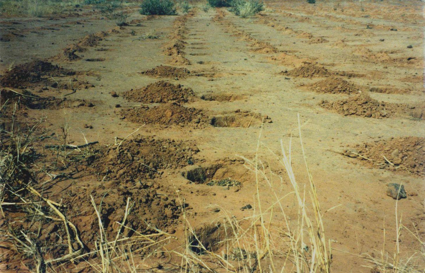
Zai or tassa planting pits [Níger]
- Criação:
- Atualização:
- Compilador/a: Dieter Nill
- Editor: –
- Revisores: Alexandra Gavilano, Deborah Niggli, Nina Lauterburg, Fabian Ottiger
Zaï - Tassa (French)
technologies_1219 - Níger
Veja as seções
Expandir tudo Recolher tudo1. Informação geral
1.2 Detalhes do contato das pessoas capacitadas e instituições envolvidas na avaliação e documentação da tecnologia
Especialista em GST:
Dorlöchter-Sulser Sabine
Misereor
Alemanha
Especialista em GST:
Mamadou Abdou Sani
Programme d’Appui à l’agriculture Productive (PROMAP)/GIZ
Níger
Nome do projeto que facilitou a documentação/avaliação da Tecnologia (se relevante)
Manual of Good Practices in Small Scale Irrigation in the Sahel (GIZ )Nome da(s) instituição(ões) que facilitou(ram) a documentação/ avaliação da Tecnologia (se relevante)
Deutsche Gesellschaft für Internationale Zusammenarbeit (GIZ) - AlemanhaNome da(s) instituição(ões) que facilitou(ram) a documentação/ avaliação da Tecnologia (se relevante)
Misereor - Alemanha1.3 Condições em relação ao uso da informação documentada através de WOCAT
O compilador e a(s) pessoa(s) capacitada(s) aceitam as condições relativas ao uso de dados documentados através do WOCAT:
Sim
1.4 Declaração de sustentabilidade da tecnologia descrita
A tecnologia descrita aqui é problemática em relação a degradação da terra de forma que não pode ser declarada uma tecnologia de gestão sustentável de terra?
Não
2. Descrição da tecnologia de GST
2.1 Descrição curta da tecnologia
Definição da tecnologia:
Zai planting pits are designed to collect rainwater and to conserve nutrients in order to improve crop production and food security.
2.2 Descrição detalhada da tecnologia
Descrição:
Zai or tassa planting pits are an old farming technique rediscovered after the great drought of 1973/74 and later perfected by development partners working with the farmers. It involves digging planting pits with a diameter of at least 30 to 40 cm and 10 to 15 cm deep. They are spaced 70 to 80 cm apart, resulting in around 10,000 pits per hectare. Staggered rows of holes are dug perpendicularly to the slope. The earth dug out of the hole is piled up to form a small ridge around the rim, which captures water. A couple of handfuls of organic fertiliser or compost are put into each pit. They are normally made in the dry season before the first rains start. However, it is recommended that the pits be made immediately after the rainy season, when the soil is still moist and the weather is not too hot. If the pits are in place early in the dry season, they act as traps during the windy period in February and March, retaining rich dust carried by the harmattan and wind-blown organic matter. At least 3 tonnes of compost per hectare is recommended.
Purpose of the Technology: The arrangement of the pits in staggered rows ensures the most efficient collection of rainwater and slows the flow of water over the surface. The zai technique concentrates and conserves nutrients and water near the roots of the plants grown in them. The application of organic fertiliser directly around the plants is an economical use of a factor of production to which most farmers have limited access. It also reactivates biological activity, increases fertility and loosens the soil.
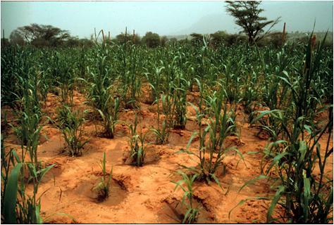
As zai planting pits restore degraded, uncultivated land, they lessen the pressure to clear other land for farming. They also reduce the vulnerability of plants during dry spells and droughts, ensuring crop production and improving food security.
Plots with zai planting pits (with fertiliser) average yields of 409 kg of millet grain per hectare, compared to 195 kg per hectare registered on control plots. Millet yields can therefore be doubled with this technique.
Establishment / maintenance activities and inputs: The zai technique requires high labour input. It is estimated that between 40 and 60 man-days per hectare are required, depending on the density of the pits. There is a mechanised system for making the holes, using a special animal-drawn plough, which considerably reduces the number of man-days required to 7 per hectare.
If the pits are prepared each year or once every two years (using the same pits or making new ones in the spaces between the old ones), soil fertility is restored and the crop cycle can be resumed. The application of organic fertiliser in sufficient quantities enables the plot to be cultivated sustainably. After five years, it can be farmed in the normal way.
Covering extensive areas with zai planting pits requires a high level of community mobilisation and effective organisation and logistics. Apart from this, the technique is very simple to implement and easily mastered by the farmers.
Natural / human environment: Zai planting pits are used on marginal or degraded land that is no longer cultivated, such as low-gradient pediments and land with encrusted soil in areas with rainfall levels of less than 800 mm a year. They are not recommended for sandy soils, as they are not stable when dug in this type of soil, or for valley bottoms, where they risk being flooded. Zai planting pits are particularly useful in areas where land use pressure is high, as they permit the rehabilitation of unproductive land for farming.
From the point of view of climate change adaptation, zai planting pits are particularly useful in areas with erratic or low rainfall, as they prevent the loss of water. As the fertiliser is placed inside the pits, it is not washed away by heavy rain.
2.3 Fotos da tecnologia
Galeria de Mídias
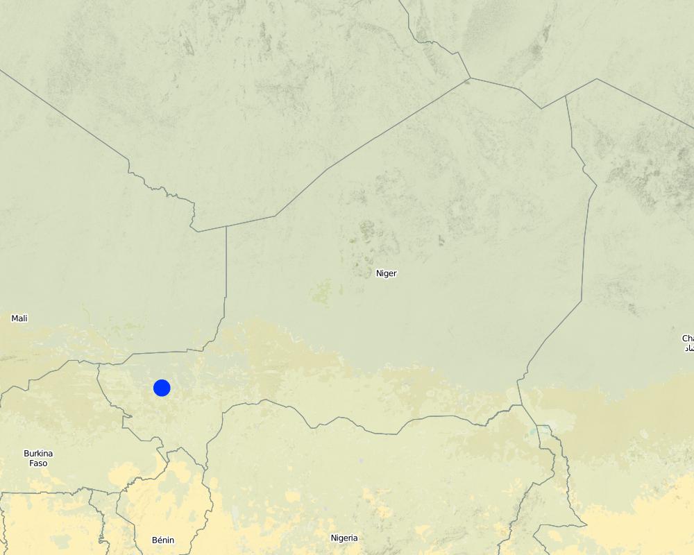
2.5 País/região/locais onde a tecnologia foi aplicada e que estão cobertos nesta avaliação
País:
Níger
Região/Estado/Província:
Niger
Especificação adicional de localização:
Regions of Tillabéri, Filingué, Ouallam, Téra and Tahuoa
Map
×2.6 Data da implementação
Caso o ano exato seja desconhecido, indique a data aproximada:
- 10-50 anos atrás
2.7 Introdução da tecnologia
Especifique como a tecnologia foi introduzida:
- através de projetos/intervenções externas
Comentários (tipos de projeto, etc.):
developed, implemented and disseminated as part of projects and programmes undertaken from the 1980s onwards to combat desertification and improve natural resource management. Implemented by GIZ (German Federal Enterprise for International Cooperation), PDRT (Projet de développement rural de Tahoua - Tahoua Rural Development Project), PASP (Projet de protection intégrée des ressources agro-sylvo-pastorales Tillabéri-Nord - Project for the Integrated Protection of Agricultural, Forest and Rangeland Resources in Tillabéri-Nord)
3. Classificação da tecnologia de GST
3.1 Principal/principais finalidade(s) da tecnologia
- Melhora a produção
- Criar impacto econômico benéfico
3.2 Tipo(s) atualizado(s) de uso da terra onde a tecnologia foi aplicada
Uso do solo misturado dentro da mesma unidade de terra:
Sim
Especificar o uso misto da terra (culturas/ pastoreio/ árvores):
- Agrossilvipecuária

Terra de cultivo
- Cultura anual
- Cultura de árvores e arbustos
Cultivo anual - Especificar culturas:
- culturas de oleaginosas - amendoim
- cereais - painço
- cereais - sorgo
- legumes e leguminosas - ervilhas
Cultivo de árvores e arbustos - Especificar culturas:
- manga, mangostão, goiaba
Número de estações de cultivo por ano:
- 1
Especifique:
Longest growing period in days: 120, Longest growing period from month to month: August to October

Pastagem
Pastagem extensiva:
- Nomadismo
- Pastoralismo semi-nômade
Pastagem intensiva/produção de forragem:
- Semiestabulação/sem pastagem
- Pastos melhorados

Floresta/bosques
- Florestas/bosques (semi)naturais
Florestas (semi)naturais/ bosques: Especificar o tipo de manejo:
- Derrubada seletiva
- Derrubada descontrolada
Produtos e serviços:
- Madeira
- Lenha
- Frutas e nozes
- Outros produtos florestais
- Pastagem/Alimentação de folhas e brotos
Comentários:
Major cash crop: Ground nut
Major food crop: Millet
Major other crops: Sorghum, cow pea and mangos
Major land use problems (compiler’s opinion): soil erosion, fertility decline, aridification, loss of limited rainwater by runoff
Type of cropping system and major crops comments: farmers are mainly agropastoralists with some communities specialised on pure pastoralism
Constraints of forested government-owned land or commons
Type of grazing land: Extensive grazing: Nomadism, semi-nomadism/pastoralism. Intensive grazing: Cut-and-carry/zero grazing and improved pasture
Livestock density: 1-10 LU / km2
3.4 Abastecimento de água
Abastecimento de água para a terra na qual a tecnologia é aplicada:
- Precipitação natural
3.5 Grupo de GST ao qual pertence a tecnologia
- Perturbação mínima ao solo
- Gestão integrada de fertilidade do solo
3.6 Medidas de GST contendo a tecnologia

Medidas agronômicas
- A2: Matéria orgânica/fertilidade do solo

Medidas estruturais
- S4: Valas de nível, fossos
3.7 Principais tipos de degradação da terra abordados pela tecnologia

Erosão do solo pela água
- Wt: Perda do solo superficial/erosão de superfície

Erosão do solo pelo vento
- Et: Perda do solo superficial

Deteriorização química do solo
- Cn: declínio de fertilidade e teor reduzido de matéria orgânica (não causado pela erosão)

Degradação biológica
- Bc: redução da cobertura vegetal

Degradação da água
- Ha: aridificação
Comentários:
Main causes of degradation: soil management (Unadapted landuse methods, reduced or abandoned fallow periods), crop management (annual, perennial, tree/shrub) (Neglect of fallow periods and crop rotation), droughts (due to heat waves), population pressure (rapidly growing population increasing pressure on land), land tenure (insecure access to land and collectively managed communal land), poverty / wealth (very poor population)
Secondary causes of degradation: deforestation / removal of natural vegetation (incl. forest fires) (deforestation through overgrazing and fire wood collection), over-exploitation of vegetation for domestic use (firewood collection), overgrazing (cattle, sheep and goats), change in temperature (Climate change: heat waves), change of seasonal rainfall (more variable onset of rain), Heavy / extreme rainfall (intensity/amounts) (more variable and intensive rains), wind storms / dust storms (frequent storms), floods (due to intensive rain storms), labour availability (some migration of men to nearby cities), education, access to knowledge and support services (high level of illiteracy)
3.8 Redução, prevenção ou recuperação da degradação do solo
Especifique o objetivo da tecnologia em relação a degradação da terra:
- Recuperar/reabilitar solo severamente degradado
4. Especificações técnicas, implementação de atividades, entradas e custos
4.1 Desenho técnico da tecnologia
Especificações técnicas (relacionada ao desenho técnico):
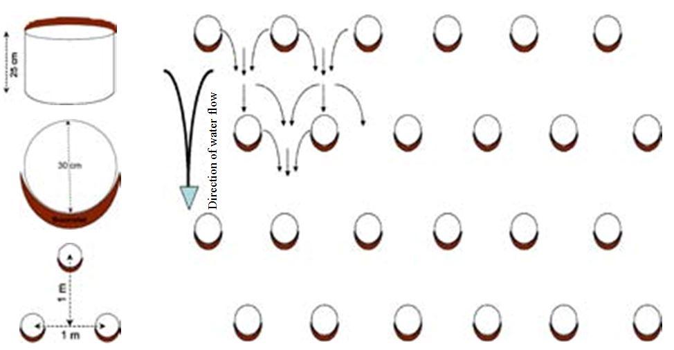
It involves digging planting pits with a diameter of at least 30 to 40 cm and 10 to 15 cm deep. They are spaced 70 to 80 cm apart, resulting in around 10,000 pits per hectare. Staggered rows of holes are dug perpendicularly to the slope. The earth dug out of the hole is piled up to form a small ridge around the rim, which captures water. A couple of handfuls of organic fertiliser or compost are put into each pit.
Location: Niger
Technical knowledge required for field staff / advisors: moderate
Technical knowledge required for land users: low
Main technical functions: control of dispersed runoff: retain / trap, control of dispersed runoff: impede / retard, control of concentrated runoff: retain / trap, control of concentrated runoff: impede / retard, increase in organic matter, increase in nutrient availability (supply, recycling,…), increase of infiltration, increase / maintain water stored in soil, water harvesting / increase water supply, sediment retention / trapping, sediment harvesting
Secondary technical functions: improvement of ground cover, stabilisation of soil (eg by tree roots against land slides), reduction in wind speed
Retention/infiltration ditch/pit, sediment/sand trap
Spacing between structures (m): 0.7-0.8
Depth of ditches/pits/dams (m): 0.15
Length of ditches/pits/dams (m): 0.3-0.4
Autor:
PASP
4.2 Informação geral em relação ao cálculo de entradas e custos
Outro/moeda nacional (especifique):
CFA Franc
4.3 Atividades de implantação
| Atividade | Periodicidade (estação do ano) | |
|---|---|---|
| 1. | marking out the rows perpendicular to the slope | |
| 2. | digging pits in staggered rows | |
| 3. | forming a ridge on the downhill side | |
| 4. | A couple of handfuls of organic fertiliser or compost are put into each pit |
4.4 Custos e entradas necessárias para a implantação
| Especifique a entrada | Unidade | Quantidade | Custos por unidade | Custos totais por entrada | % dos custos arcados pelos usuários da terra | |
|---|---|---|---|---|---|---|
| Mão-de-obra | labour | 1,0 | 16,3 | 16,3 | ||
| Mão-de-obra | transport and planting trees | 1,0 | 12,3 | 12,3 | ||
| Equipamento | machine use | 1,0 | 23,6 | 23,6 | ||
| Material vegetal | seedlings | |||||
| Custos totais para a implantação da tecnologia | 52,2 | |||||
| Custos totais para o estabelecimento da Tecnologia em USD | 52,2 | |||||
4.5 Atividades recorrentes/manutenção
| Atividade | Periodicidade/frequência | |
|---|---|---|
| 1. | the pits are prepared each year or once every two years (using the same pits or making new ones in the spaces between the old ones | |
| 2. | applying organic fertiliser every two years (1 to 2 hand-fuls per pit, amounting to around 3 tonnes per hectare). |
4.7 Fatores mais importantes que afetam os custos
Descreva os fatores mais determinantes que afetam os custos:
Labour: 40 to 60 man-days per hectare
• marking out the rows perpendicular to the slope
• digging pits in staggered rows
• forming a ridge on the downhill side
• applying organic fertiliser every two years (1 to 2 handfuls per pit, amounting to around 3 tonnes per hectare).
Other costs: transportation of 30 cartloads of manure.
5. Ambiente natural e humano
5.1 Clima
Precipitação pluviométrica anual
- <250 mm
- 251-500 mm
- 501-750 mm
- 751-1.000 mm
- 1.001-1.500 mm
- 1.501-2.000 mm
- 2.001-3.000 mm
- 3.001-4.000 mm
- > 4.000 mm
Zona agroclimática
- Semiárido
Thermal climate class: subtropics
5.2 Topografia
Declividade média:
- Plano (0-2%)
- Suave ondulado (3-5%)
- Ondulado (6-10%)
- Moderadamente ondulado (11-15%)
- Forte ondulado (16-30%)
- Montanhoso (31-60%)
- Escarpado (>60%)
Formas de relevo:
- Planalto/planície
- Cumes
- Encosta de serra
- Encosta de morro
- Sopés
- Fundos de vale
Zona de altitude:
- 0-100 m s.n.m.
- 101-500 m s.n.m.
- 501-1.000 m s.n.m.
- 1.001-1.500 m s.n.m.
- 1.501-2.000 m s.n.m.
- 2.001-2.500 m s.n.m.
- 2.501-3.000 m s.n.m.
- 3.001-4.000 m s.n.m.
- > 4.000 m s.n.m.
5.3 Solos
Profundidade do solo em média:
- Muito raso (0-20 cm)
- Raso (21-50 cm)
- Moderadamente profundo (51-80 cm)
- Profundo (81-120 cm)
- Muito profundo (>120 cm)
Textura do solo (solo superficial):
- Médio (limoso, siltoso)
- Fino/pesado (argila)
Matéria orgânica do solo superficial:
- Baixo (<1%)
Caso disponível anexe a descrição completa do solo ou especifique as informações disponíveis, p. ex. tipo de solo, PH/acidez do solo, nitrogênio, capacidade de troca catiônica, salinidade, etc.
Soil texture: Fine to medium (sandy to clayey loams)
Soil fertility: Very low to medium
Soil drainage/infiltration: Poor and medium (ranked 2)
Soil water storage capacity: Low and medium (ranked 2)
5.4 Disponibilidade e qualidade de água
Lençol freático:
5-50 m
Disponibilidade de água de superfície:
Médio
Qualidade da água (não tratada):
apenas para uso agrícola (irrigação)
5.5 Biodiversidade
Diversidade de espécies:
- Baixo
5.6 Características dos usuários da terra que utilizam a tecnologia
Orientação de mercado do sistema de produção:
- Subsistência (autoabastecimento)
Nível relativo de riqueza:
- Muito pobre
- Pobre
Nível de mecanização:
- Trabalho manual
- Tração animal
Gênero:
- Homens
Indique outras características relevantes dos usuários da terra:
Population density: 10-50 persons/km2
Annual population growth: 3% - 4% (mostly poor households below poverty line).
Off-farm income specification: men migrate temporarily or permanently to cities for off-farm income, women and men seasonally carry out paid farm work
Market orientation of production system: subsistence (self-supply, Most households crop for subsistence, mainly for small agropastoralists ), mixed (subsistence/commercial, crop surplus is sold on market, medium agropastoralists) and commercial market (Some vegetable growing, pastoralists)
Level of mechanization: Menual work (ranked 1) and animal traction (ranked 2, ox, donkey)
5.7 Área média de terrenos utilizados pelos usuários de terrenos que aplicam a Tecnologia
- < 0,5 ha
- 0,5-1 ha
- 1-2 ha
- 2-5 ha
- 5-15 ha
- 15-50 ha
- 50-100 ha
- 100-500 ha
- 500-1.000 ha
- 1.000-10.000 ha
- > 10.000 ha
É considerado pequena, média ou grande escala (referente ao contexto local)?
- Pequena escala
5.8 Propriedade de terra, direitos de uso da terra e de uso da água
Comentários:
traditional land use rights prevail. On fields individual land use rights, communal rights on pasture and forest land (collection of wood and other products (fruits, medicinal plants))
5.9 Acesso a serviços e infraestrutura
Saúde:
- Pobre
- Moderado
- Bom
Educação:
- Pobre
- Moderado
- Bom
Assistência técnica:
- Pobre
- Moderado
- Bom
Emprego (p. ex. não agrícola):
- Pobre
- Moderado
- Bom
Mercados:
- Pobre
- Moderado
- Bom
Energia:
- Pobre
- Moderado
- Bom
Vias e transporte:
- Pobre
- Moderado
- Bom
Água potável e saneamento:
- Pobre
- Moderado
- Bom
Serviços financeiros:
- Pobre
- Moderado
- Bom
6. Impactos e declarações finais
6.1 Impactos no local mostrados pela tecnologia
Impactos socioeconômicos
Produção
Produção agrícola
Risco de falha de produção
Área de produção
Renda e custos
Rendimento agrícola
Carga de trabalho
Impactos socioculturais
Segurança alimentar/auto-suficiência
Conhecimento de GST/ degradação da terra
Improved livelihoods and human well-being
Comentários/especificar:
Plots with zai planting pits (with fertiliser) average yields of 409 kg of millet grain per hectare, compared to 195 kg per hectare registered on control plots. Millet yields can therefore be doubled with this technique. They also reduce the vulnerability of plants during dry spells and droughts, ensuring crop production and improving food security.
Impactos ecológicos
Ciclo hídrico/escoamento
Escoamento superficial
Solo
Umidade do solo
Cobertura do solo
Ciclo e recarga de nutrientes
Matéria orgânica do solo/carbono abaixo do solo
Biodiversidade: vegetação, animais
Diversidade vegetal
Clima e redução de riscos de desastre
Velocidade do vento
Outros impactos ecológicos
Waterlogging in planting pits after heavy rains
6.2 Impactos externos mostrados pela tecnologia
Cheias de jusante
Sedimentação a jusante
6.3 Exposição e sensibilidade da tecnologia às mudanças climáticas graduais e extremos/desastres relacionados ao clima (conforme o ponto de vista dos usuários da terra)
Mudança climática gradual
Mudança climática gradual
| Estação do ano | aumento ou diminuição | Como a tecnologia lida com isso? | |
|---|---|---|---|
| Temperatura anual | aumento | bem |
Extremos (desastres) relacionados ao clima
Desastres meteorológicos
| Como a tecnologia lida com isso? | |
|---|---|
| Temporal local | não bem |
| Tempestade de vento local | bem |
Desastres climatológicos
| Como a tecnologia lida com isso? | |
|---|---|
| Seca | bem |
Desastres hidrológicos
| Como a tecnologia lida com isso? | |
|---|---|
| Inundação geral (rio) | não bem |
Outras consequências relacionadas ao clima
Outras consequências relacionadas ao clima
| Como a tecnologia lida com isso? | |
|---|---|
| Período de crescimento reduzido | não conhecido |
6.4 Análise do custo-benefício
Como os benefícios se comparam aos custos de implantação (do ponto de vista dos usuários da terra)?
Retornos a curto prazo:
positivo
Retornos a longo prazo:
muito positivo
Como os benefícios se comparam aos custos recorrentes/de manutenção(do ponto de vista dos usuários da terra)?
Retornos a curto prazo:
muito positivo
Retornos a longo prazo:
muito positivo
6.7 Pontos fortes/vantagens/oportunidades da tecnologia
| Pontos fortes/vantagens/oportunidades na visão do compilador ou de outra pessoa capacitada |
|---|
| The arrangement of the pits in staggered rows ensures the most efficient collection of rainwater and slows the flow of water over the surface. The zai technique concentrates and conserves nutrients and water near the roots of the plants grown in them. |
| Zai planting pits are particularly useful in areas where land use pressure is high, as they permit the rehabilitation of unproductive land for farming. Therefore they lessen the pressure to clear other land for farming. |
| They also reduce the vulnerability of plants during dry spells and droughts, ensuring crop production and im- proving food security. |
| It permits a rational use of fertiliser. When fertiliser is spread on the surface of a plot without zai planting pits, it can be washed away by runoff. |
| very simple to implement and easily mastered by the farmers |
6.8 Pontos fracos, desvantagens/riscos da tecnologia e formas de superá-los
| Pontos fracos/vantagens/riscos na visão do compilador ou de outra pessoa capacitada | Como eles podem ser superados? |
|---|---|
| The zai technique requires high labour input. | |
| Zai planting pits are not recommended for light soils, as they fill in too quickly |
7. Referências e links
7.1 Métodos/fontes de informação
- visitas de campo, pesquisas de campo
- entrevistas com usuários de terras
Quando os dados foram compilados (no campo)?
01/07/2012
7.3 Links para informações on-line relevantes
Título/ descrição:
Good Practices in Soil and Water Conservation. A contribution to adaptation and farmers´ resilience towards climate change in the Sahel. Published by GIZ in 2012.
URL:
http://agriwaterpedia.info/wiki/Main_Page
Links e módulos
Expandir tudo Recolher tudoLinks
Não há links
Módulos
Não há módulos