Shelterbelts for farmland in sandy areas [China]
- Criação:
- Atualização:
- Compilador/a: Meili WEN
- Editor: –
- Revisores: David Streiff, Deborah Niggli, Alexandra Gavilano
Farmland shelter belt
technologies_1366 - China
Veja as seções
Expandir tudo Recolher tudo1. Informação geral
1.2 Detalhes do contato das pessoas capacitadas e instituições envolvidas na avaliação e documentação da tecnologia
Especialista em GST:
Wang Dogmei
China
Nome do projeto que facilitou a documentação/avaliação da Tecnologia (se relevante)
Book project: where the land is greener - Case Studies and Analysis of Soil and Water Conservation Initiatives Worldwide (where the land is greener)Nome da(s) instituição(ões) que facilitou(ram) a documentação/ avaliação da Tecnologia (se relevante)
GEF/OP12 Gansu Project (GEF/OP12 Gansu Project) - China1.3 Condições em relação ao uso da informação documentada através de WOCAT
O compilador e a(s) pessoa(s) capacitada(s) aceitam as condições relativas ao uso de dados documentados através do WOCAT:
Sim
1.5 Referência ao(s) questionário(s) sobre abordagens GST (documentado(s) usando WOCAT)
Shelter Belt [China]
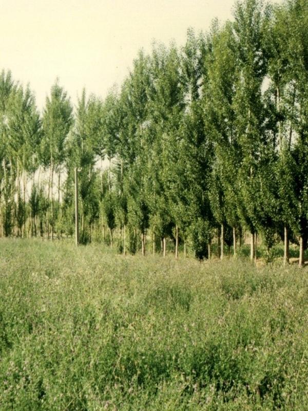
The shelter belt is a strip or a row of trees planted in a farmland as a wind barrier to protect crops and reduce wind erosion.
- Compilador/a: Meili WEN
2. Descrição da tecnologia de GST
2.1 Descrição curta da tecnologia
Definição da tecnologia:
Belts of trees, planted in a rectangular grid pattern or in strips within, and on the periphery of, farmland to act as windbreaks.
2.2 Descrição detalhada da tecnologia
Descrição:
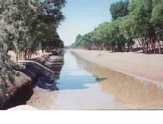
Shelterbelts to protect cropland are a specific type of agroforestry system comprising certain tall growing tree species. Such shelterbelts around farmland help reduce natural hazards including sandstorms, wind erosion, shifting sand, droughts and frost. They also improve the microclimate (reduced temperature, wind speed, soil water loss and excessive wind-induced transpiration) and create more favourable conditions for crop production. Thus the establishment of shelterbelts plays a crucial role in the sandy drylands that are affected by wind and resultant desertification
especially during winter and spring. Where there is irrigation, the shelterbelts protect the infrastructure from silting-up with wind-borne sediment.
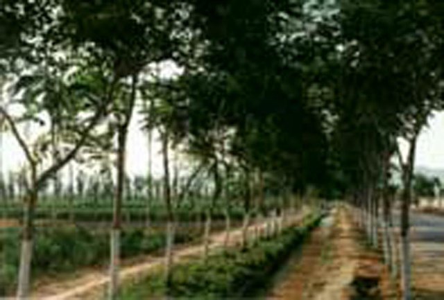
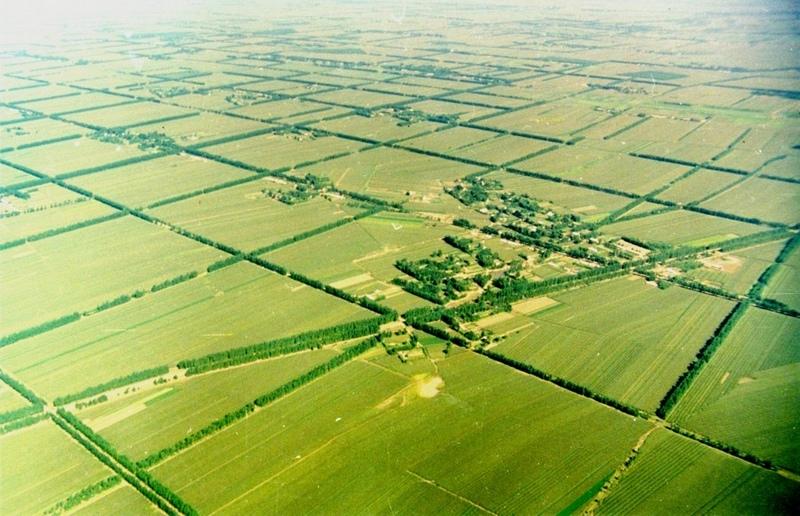
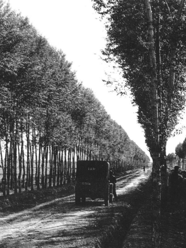
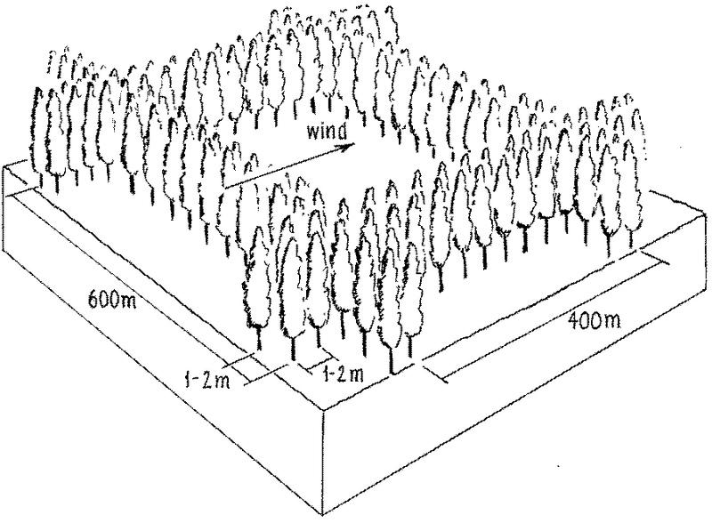
Strips of tall growing species (15-25 m) of poplar (Populus spp.) or willow (Salix spp.) were originally (from 1960s onwards) planted in a 400 by 600 m rectangular grid pattern within extensive areas of cropland, with an extra belt of windbreaks on the windward side (against the prevailing wind). Generally, the distance effectively protected is 15-25 times the tree height. Strips are of variable width, consisting of 2-5 tree lines (1-3 m apart) with trees planted every 1-2 m within the lines. Selective felling is used to maintain adequate growing space and the protective effect of the trees.
The impact of the shelterbelts depends on the planting pattern of the trees (the format of strips and grids), the orientation of the shelterbelts in relation to the wind, the spacing between, and the width of each strip and the type of trees planted. The specific design is primarily based on preventing the negative effects of wind, but depends also on local conditions such as the layout of the land, the location of the roads, farm boundaries and irrigation canals. Ideally the tree strips are perpendicular to the prevailing wind direction, and the angle between the strip and the prevailing wind is never less than 45 degrees. The structure of the strips determines the way the wind is controlled, ranging from blocking the wind
to letting it diffuse through semi-permeable shelterbelts. The best effect is achieved if the wind is not blocked entirely, as this can cause turbulence.
The ownership of the land and the shelterbelts still rests with the state, but management has been more and more transferred to individual households. On condition that the impact of the shelterbelt is not affected, the local forestry agencies now allow some felling of mature trees - on a rotational and selective basis, for timber and firewood. Pine trees (Pinus sylvestris var. mongolica and P. tabulaeformis), which command high value as timber for construction, and fruit (and cash) trees like the apricot tree (Prunus armeniace) are increasingly used.
2.3 Fotos da tecnologia
Galeria de Mídias
2.5 País/região/locais onde a tecnologia foi aplicada e que estão cobertos nesta avaliação
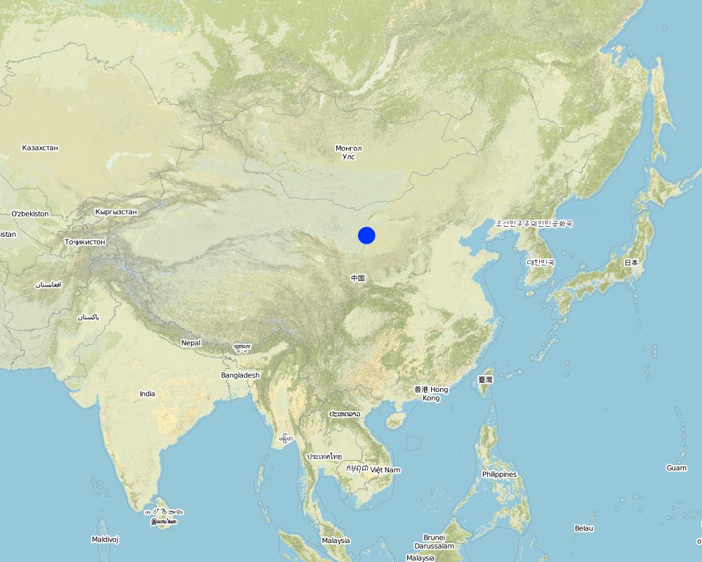
País:
China
Região/Estado/Província:
Inner Mongolia Autonomous Region
Especifique a difusão da tecnologia:
- Uniformemente difundida numa área
Se a Tecnologia estiver uniformemente distribuída por uma área, especifique a área coberta (em km2):
500,0
Se a área precisa não for conhecida, indicar a área aproximada coberta:
- 100-1.000 km2
Comentários:
Total area covered by the SLM Technology is 500 km2.
Total SWC Technology area is not clear. This technology area data is from Inner Mongolia forest department. Inner Mongolia autonomy region forest statistic data, 1987, P75. Technology beginning year is from: Water and soil conservation bureau, Yellow River irrigation works committee of Department of water and electricity. Water and soil conservation economy benefit thesis collecting,1987, P45-47.
Map
×2.6 Data da implementação
Caso o ano exato seja desconhecido, indique a data aproximada:
- mais de 50 anos atrás (tradicional)
2.7 Introdução da tecnologia
Especifique como a tecnologia foi introduzida:
- através de projetos/intervenções externas
Comentários (tipos de projeto, etc.):
USA and domestic.
3. Classificação da tecnologia de GST
3.1 Principal/principais finalidade(s) da tecnologia
- Reduzir riscos de desastre
- Adaptar a mudanças climáticas/extremos e seus impactos
3.2 Tipo(s) atualizado(s) de uso da terra onde a tecnologia foi aplicada
Uso do solo misturado dentro da mesma unidade de terra:
Sim
Especificar o uso misto da terra (culturas/ pastoreio/ árvores):
- Agrofloresta

Terra de cultivo
- Cultura anual
Cultivo anual - Especificar culturas:
- cereais - milho
- wheat
Número de estações de cultivo por ano:
- 1
Especifique:
Longest growing period in days: 150Longest growing period from month to month: May - Sep

Floresta/bosques
- Florestas/bosques (semi)naturais
- Plantação de árvores, reflorestamento
Florestas (semi)naturais/ bosques: Especificar o tipo de manejo:
- Derrubada seletiva
Tipo de árvore:
- Espécies de pinho
- Espécies Populus
- Salix spp
Produtos e serviços:
- Madeira
- Lenha
- Frutas e nozes
- Proteção contra desastres naturais
Comentários:
Trees/ shrubs species: Poplars (Populus spp.), willows (Salix spp.), increasingly also pine (Pinus sylvestris var. Mongolic
Major land use problems (compiler’s opinion): Strong winds in the winter and spring result in serious natural hazards including sand storms, sand encroachment and wind erosion, while dry and hot winds in the summer increase transpiration leading to plant stress and reduced crop yields.
Major land use problems (land users’ perception): Low yield and intensive wind blow in winter and spring.
3.3 O uso do solo mudou devido à implementação da Tecnologia?
O uso do solo mudou devido à implementação da Tecnologia?
- Sim (Por favor, preencha as perguntas abaixo com relação ao uso do solo antes da implementação da Tecnologia)
Terra de cultivo
- Cultura anual
3.4 Abastecimento de água
Abastecimento de água para a terra na qual a tecnologia é aplicada:
- Misto de precipitação natural-irrigado
3.5 Grupo de GST ao qual pertence a tecnologia
- Agrofloresta
- Quebra-vento/cerca de árvores
3.6 Medidas de GST contendo a tecnologia

Medidas vegetativas
- V1: cobertura de árvores/arbustos

Medidas de gestão
- M1: Mudança no tipo de uso da terra
Comentários:
Main measures: vegetative measures
Type of vegetative measures: aligned: -against wind
3.7 Principais tipos de degradação da terra abordados pela tecnologia

Erosão do solo pelo vento
- Et: Perda do solo superficial
- Eo: efeitos de degradação externa

Degradação da água
- Ha: aridificação
Comentários:
Main type of degradation addressed: Et: loss of topsoil, Eo: offsite degradation effects, Ha: aridification
Main causes of degradation: deforestation / removal of natural vegetation (incl. forest fires), poverty / wealth (Lack of captial)
Secondary causes of degradation: overgrazing, education, access to knowledge and support services (Lack of knowledge), Lack of enforcement of legislat./authority
3.8 Redução, prevenção ou recuperação da degradação do solo
Especifique o objetivo da tecnologia em relação a degradação da terra:
- Reduzir a degradação do solo
Comentários:
Main goals: mitigation / reduction of land degradation
4. Especificações técnicas, implementação de atividades, entradas e custos
4.1 Desenho técnico da tecnologia
Especificações técnicas (relacionada ao desenho técnico):
Overview of the shelterbelt layout.
Insert 1: Planting scheme: shelterbelts compromise 2-5 tree lines forming the windbreak about 5-15 m wide and 15-25 m high.
Insert 2: Rectangle grid layout of shelterbelts. Spacing of the rows is denser against the prevailing wind.
Technical knowledge required for field staff / advisors: moderate
Technical knowledge required for land users: low
Main technical functions: increase / maintain water stored in soil, reduction in wind speed, protection from wind erosion, protection from sand encroachment, protection of crops from mechanical damage, reduction in evaporation loss
Secondary technical functions: increase in organic matter
Aligned: -against wind
Vegetative material: T : trees / shrubs
Trees/ shrubs species: Poplars (Populus spp.), willows (Salix spp.), increasingly also pine (Pinus sylvestris var. Mongolic)
Autor:
Mats Gurtner
4.2 Informação geral em relação ao cálculo de entradas e custos
Especifique como custos e entradas foram calculados:
- por área de tecnologia
Indique o tamanho e a unidade de área:
ha
Especifique a moeda utilizada para os cálculos de custo:
- USD
Indique a média salarial da mão-de-obra contratada por dia:
1.20
4.3 Atividades de implantação
| Atividade | Periodicidade (estação do ano) | |
|---|---|---|
| 1. | 1 Planning / designing of shelterbelt. | |
| 2. | 2 Selection and collection of trees seedlings. | |
| 3. | 3 Clearing and preparing land for planting of shelterbelt in | late autumn and spring |
| 4. | 3 Clearing and preparing land for planting of shelterbelt in | |
| 5. | 4 Pits for planting the seedlings are dug | 4 Pits for planting the seedlings are dug |
| 6. | 5 Tree seedlings are planted | late spring |
| 7. | 6 After planting each seedling is watered for up to two years. |
4.4 Custos e entradas necessárias para a implantação
| Especifique a entrada | Unidade | Quantidade | Custos por unidade | Custos totais por entrada | % dos custos arcados pelos usuários da terra | |
|---|---|---|---|---|---|---|
| Mão-de-obra | Mainly collection and planting | ha | 79,0 | 1,2 | 94,8 | |
| Equipamento | tools | ha | 1,0 | 5,0 | 5,0 | 100,0 |
| Material vegetal | tree seedlings | ha | 1,0 | 25,0 | 25,0 | |
| Custos totais para a implantação da tecnologia | 124,8 | |||||
| Custos totais para o estabelecimento da Tecnologia em USD | 124,8 | |||||
Se o usuário da terra arca com menos que 100% dos custos, indique quem cobre os custos remanescentes:
USA and domestic projects
Comentários:
Duration of establishment phase: 36 month(s)
4.5 Atividades recorrentes/manutenção
| Atividade | Periodicidade/frequência | |
|---|---|---|
| 1. | Watering | after planting /timely |
| 2. | Pruning of trees. | |
| 3. | Pest and disease control within shelterbelt. | |
| 4. | Intermediate/ selective tree felling. |
4.6 Custos e entradas necessárias pata a manutenção/atividades recorrentes (por ano)
| Especifique a entrada | Unidade | Quantidade | Custos por unidade | Custos totais por entrada | % dos custos arcados pelos usuários da terra | |
|---|---|---|---|---|---|---|
| Mão-de-obra | Watering and Pruning | ha | 7,0 | 1,2 | 8,4 | 100,0 |
| Material vegetal | tree seedling | ha | 1,0 | 3,0 | 3,0 | 100,0 |
| Custos totais para a manutenção da tecnologia | 11,4 | |||||
| Custos totais de manutenção da Tecnologia em USD | 11,4 | |||||
Comentários:
The costs are calculated according to current standards/costs. The original planting is paid for by the state: replanting
and maintenance are the responsibility of the land user. If pines are the species of choice for re-planting, the cost
is considerably more than that shown above (which relates to poplar and willow).
Assuming: shelterbelts of 600 m by 400 m; each strip has 5 lines of trees (3 m apart), 2 m between trees within lines: resulting in 104 trees/ha, including the cropland between the strips (density within strips is 1666 trees/ha). Labour for establishment (104 trees): Land preparation, planting 10 days and 15 days for watering, weeding, etc (for first 3 years).
4.7 Fatores mais importantes que afetam os custos
Descreva os fatores mais determinantes que afetam os custos:
The most important factors to affect the costs are seedlings (No.) and machine.
5. Ambiente natural e humano
5.1 Clima
Precipitação pluviométrica anual
- <250 mm
- 251-500 mm
- 501-750 mm
- 751-1.000 mm
- 1.001-1.500 mm
- 1.501-2.000 mm
- 2.001-3.000 mm
- 3.001-4.000 mm
- > 4.000 mm
Especifique a média pluviométrica anual em mm (se conhecida):
430,00
Zona agroclimática
- Semiárido
5.2 Topografia
Declividade média:
- Plano (0-2%)
- Suave ondulado (3-5%)
- Ondulado (6-10%)
- Moderadamente ondulado (11-15%)
- Forte ondulado (16-30%)
- Montanhoso (31-60%)
- Escarpado (>60%)
Formas de relevo:
- Planalto/planície
- Cumes
- Encosta de serra
- Encosta de morro
- Sopés
- Fundos de vale
Zona de altitude:
- 0-100 m s.n.m.
- 101-500 m s.n.m.
- 501-1.000 m s.n.m.
- 1.001-1.500 m s.n.m.
- 1.501-2.000 m s.n.m.
- 2.001-2.500 m s.n.m.
- 2.501-3.000 m s.n.m.
- 3.001-4.000 m s.n.m.
- > 4.000 m s.n.m.
Indique se a tecnologia é aplicada especificamente em:
- Não relevante
5.3 Solos
Profundidade do solo em média:
- Muito raso (0-20 cm)
- Raso (21-50 cm)
- Moderadamente profundo (51-80 cm)
- Profundo (81-120 cm)
- Muito profundo (>120 cm)
Textura do solo (solo superficial):
- Grosso/fino (arenoso)
Matéria orgânica do solo superficial:
- Médio (1-3%)
Caso disponível anexe a descrição completa do solo ou especifique as informações disponíveis, p. ex. tipo de solo, PH/acidez do solo, nitrogênio, capacidade de troca catiônica, salinidade, etc.
Soil fertility: low -medium
Soil drainage / infiltration: good
Soil water storage capacity: medium
5.6 Características dos usuários da terra que utilizam a tecnologia
Orientação de mercado do sistema de produção:
- misto (subsistência/comercial)
Rendimento não agrícola:
- 10-50% de toda renda
Nível relativo de riqueza:
- Média
Nível de mecanização:
- Mecanizado/motorizado
Indique outras características relevantes dos usuários da terra:
Population density: 10-50 persons/km2
Annual population growth: 1% - 2%
80% of the land users are average wealthy and own 35% of the land.
Off-farm income specification: farmers benefit from the shelterbelts as a source of off-farm income, through fodder, timber and firewood
5.7 Área média de terrenos utilizados pelos usuários de terrenos que aplicam a Tecnologia
- < 0,5 ha
- 0,5-1 ha
- 1-2 ha
- 2-5 ha
- 5-15 ha
- 15-50 ha
- 50-100 ha
- 100-500 ha
- 500-1.000 ha
- 1.000-10.000 ha
- > 10.000 ha
5.8 Propriedade de terra, direitos de uso da terra e de uso da água
- communal/state
- individual (see Annex T3 for remark)
- individual (see Annex T3 for remark)
6. Impactos e declarações finais
6.1 Impactos no local mostrados pela tecnologia
Impactos socioeconômicos
Produção
Produção agrícola
Produção de madeira
Área de produção
Comentários/especificar:
width of the shelterbelt
Renda e custos
Rendimento agrícola
Outros impactos socioeconômicos
off-farm income
Comentários/especificar:
extra timber and firewood
Crop production
Comentários/especificar:
Trees in competition with crops for solar radiation, fertilizer, and water
Impactos socioculturais
Atenuação de conflitos
Loss of Food per agricultural land
Comentários/especificar:
shelterbelts of trees are not a direct source of food
Impactos ecológicos
Ciclo hídrico/escoamento
Escoamento superficial
Quantidade anterior à GST:
8
Quantidade posterior à GST:
0
Solo
Umidade do solo
Cobertura do solo
Perda de solo
Quantidade anterior à GST:
4
Quantidade posterior à GST:
2
Clima e redução de riscos de desastre
Velocidade do vento
Outros impactos ecológicos
sand encroachment
microclimate for crops
Comentários/especificar:
regulating temperature, increasing humidity
conservation/maintenance of soil fertility
6.4 Análise do custo-benefício
Como os benefícios se comparam aos custos recorrentes/de manutenção(do ponto de vista dos usuários da terra)?
Retornos a curto prazo:
levemente positivo
Retornos a longo prazo:
muito positivo
6.5 Adoção da tecnologia
- casos isolados/experimental
Se disponível, determine a quantidade (número de unidades familiares e/ou área abordada):
40 households in an area of 100-1000km^2 (10-50 persons/km^2)
De todos aqueles que adotaram a Tecnologia, quantos o fizeram espontaneamente, ou seja, sem receber nenhum incentivo/ pagamento material?
- 0-10%
Comentários:
100% of land user families have adopted the Technology with external material support
40 land user families have adopted the Technology with external material support
Comments on acceptance with external material support: estimates
Comments on spontaneous adoption: estimates
There is no trend towards spontaneous adoption of the Technology
Comments on adoption trend: The technology has not spontaneously spread beyond the areas developed through government intervention.
6.7 Pontos fortes/vantagens/oportunidades da tecnologia
| Pontos fortes/vantagens/oportunidades na visão do compilador ou de outra pessoa capacitada |
|---|
|
Reduced wind speed and trapped wind-blown sand particle How can they be sustained / enhanced? Combine deciduous and evergreen trees to maintain shelterbelt’s protective function throughtout the year. |
|
Increased crop yield How can they be sustained / enhanced? Extend shelterbelt technology to unprotected croplands. |
|
Increased cash income How can they be sustained / enhanced? Improve rotational felling regimes that maximise quantity and quality of tree products (timber; fruit etc) without reducing the shelterbelt’s protective function. In Inner Mongolia apricot (Prunus armeniaca) and sea buckthorn (Hippophae rhamnoides) and in Gansu Province the Chinese dates (Ziziphus jujuba) are increasingly used. |
|
Apart from their effect on the wind, the overall benefits of the shelterbelts - for timber, firewood, fruits and fodder for animals - outweigh the loss of cropland occupied by trees How can they be sustained / enhanced? Experience over 40 years has demonstrated that narrower trees strips and smaller grid size (100 by 200 m) would increase ecological efficiency, but due to higher costs and potential competition with crops, the spacing of the shelterbelts has mostly remained as it was originally. |
|
From 1960 onwards, approximately 22 million hectares – of vulnerable cropland have been protected in eastern Inner Mongolia Editors’ comments: In China, a total of 1.84 million km2 suffer from desertification related to sand storms, shifting sands and wind erosion, making up 19% of the total land area. In those dry and desertified zones, farmland is barely productive, even with irrigation. The construction of shelterbelts in this northeastern part of China has had multiple benefits that outweigh the loss of cropland. However, maintenance has become an important issue with the changes in China’s land use laws. This is one of two examples of windbreaks amongst the case studies in this book. Remark: In the 1960s, all land ownership and land use rights in China were communal and cropland was farmed collectively by village communes. After reform and open policy was put into practice in 1978, land use rights were transferred to the villages, to groups and individuals. Land itself and the shelterbelts however still belonged to the state. Nowadays the rights to cultivate specific parcels of land, within protected blocks, are generally granted to individual farm households. In some cases, in recent years, the shelterbelts too have been redistributed to individuals to look after. Inevitably maintenance has become an issue. But most of the shelterbelts are managed well. 3.2.8: If farmer cuts mature timber (for example a 40 year-old poplar), he/she can sell it for US$ 20–25 per tree. With maturity of shelterbelts, the timber production increases, which brings increasing economic benefits; meanwhile, the effect of protection from wind erosion also improves. |
6.8 Pontos fracos, desvantagens/riscos da tecnologia e formas de superá-los
| Pontos fracos/vantagens/riscos na visão do compilador ou de outra pessoa capacitada | Como eles podem ser superados? |
|---|---|
| Loss of land due to area used for the shelterbelts | In this wind-prone part of Inner Mongolia, overall gains from the protected zones compensate for the reduced area under crops, especially if economically valuable species are planted in the shelterbelt, such as Caragana korshinskii, which can be used as forage, for 'green fertilizer' through leaf mulch and for firewood. |
| Competition for sunshine, fertilizer and water | Pruning of branches and digging of ditches to prevent roots penetrating the adjacent cropland |
| Farmers lost the right to crop the tree-occupied land (since the shelterbelts belonged to the state). Originally, farmers were not allowed to fell trees | Nowadays the local forestry department permits farmers to occasionally cut trees, which is a source of income. If land users were allowed to cut trees on a more systematic basis, it would help them to better appreciate the benefits. |
| High cost (labour and money) for establishment | Government support required. |
|
Shelterbelts comprised of single tree species are less resistant to pests and diseases Shelterbelts consume more water |
Combine trees and shrubs/ different species, which improves both resistance and also the protective effect. But they also help in drainage (where this is a problem) through lowering the ground water table and simultaneously reducing salinity. Appropriate tree species need to be selected and bred. |
7. Referências e links
7.1 Métodos/fontes de informação
7.2 Referências às publicações disponíveis
Título, autor, ano, ISBN:
China atlas. China atlas publishing house, P 52.. 1999.
Disponível de onde? Custos?
library of Department of Resource and Environmental Science, BNU.
Título, autor, ano, ISBN:
Zhao Yu, Jing Zhengping, Shi Peijun, Hao Yunchong et al. Inner Mongolia soil erosion research remote sensing was used in Inner Mongolia soil erosion research, Science publishing house, P25.. 1989.
Disponível de onde? Custos?
library of Department of Resource and Environmental Science, BNU.
Título, autor, ano, ISBN:
Inner Mongolia forest department, Forest work manual,12, P33-34, P67.. 1998.
Disponível de onde? Custos?
library of Department of Resource and Environmental Science, BNU.
Título, autor, ano, ISBN:
Synthesized investigate team in Inner Mongolia-Ningxia, CAS. West of northeast Forest in Inner Mongolia autonomy region, Science publishing house, P82-101.. 1981.
Disponível de onde? Custos?
library of Department of Resource and Environmental Science, BNU.
Título, autor, ano, ISBN:
Sun Jinzhu. Natural condition and reconstruct in Hetao plain, Inner Mongolia people' s publishing house, P188-189.. 1976.
Disponível de onde? Custos?
library of Department of Resource and Environmental Science, BNU.
Título, autor, ano, ISBN:
Inner Mongolia forest Department. Inner Mongolia autonomy region forest statistic data,P75.. 1987.
Disponível de onde? Custos?
library of Department of Resource and Environmental Science, BNU.
Título, autor, ano, ISBN:
Hu Chun(chief editor). Inner Mongolia autonomy region climate resources about agriculture, forest and animal husbandry, Inner Mongolia people's publishing house, P45-47.. 1984.
Disponível de onde? Custos?
library of Department of Resource and Environmental Science, BNU.
Título, autor, ano, ISBN:
Water and soil conservation bureau, Yellow River irrigation works committee of Department of water and electricity. Water and soil conservation economy benefit thesis collecting, P45-47.. 1987.
Disponível de onde? Custos?
library of Department of Resource and Environmental Science, BNU.
Título, autor, ano, ISBN:
Zhang Pangchuen, A study on the benefit of shelter belt in the south part of Kerqin sand to agriculture increase in production. Journal of arid land resource and environment. Vol.4, no.1, P11-87.. 1990.
Disponível de onde? Custos?
library of Department of Resource and Environmental Science, BNU.
Título, autor, ano, ISBN:
Sun Jinzhu,Chen Shan(chief editor). Inner Mongolia environment alarm beforehand and repair countermeasure. Inner Mongolia people's publishing house, P132.. 1994.
Disponível de onde? Custos?
library of Department of Resource and Environmental Science, BNU.
Título, autor, ano, ISBN:
Compilation Committee of Inner Mongolia Forest Inner Mongolia Forest, Beijing: China Forestry Publishing House, 1989,299–319. 1989.
Links e módulos
Expandir tudo Recolher tudoLinks
Shelter Belt [China]
The shelter belt is a strip or a row of trees planted in a farmland as a wind barrier to protect crops and reduce wind erosion.
- Compilador/a: Meili WEN
Módulos
Não há módulos