Bench terraces on loess soil [China]
- Criação:
- Atualização:
- Compilador/a: Fei WANG
- Editor: –
- Revisores: David Streiff, Alexandra Gavilano
土坎梯田,梯地
technologies_1445 - China
Veja as seções
Expandir tudo Recolher tudo1. Informação geral
1.2 Detalhes do contato das pessoas capacitadas e instituições envolvidas na avaliação e documentação da tecnologia
Especialista em GST:
1.3 Condições em relação ao uso da informação documentada através de WOCAT
O compilador e a(s) pessoa(s) capacitada(s) aceitam as condições relativas ao uso de dados documentados através do WOCAT:
Sim
2. Descrição da tecnologia de GST
2.1 Descrição curta da tecnologia
Definição da tecnologia:
A Terrace is a structural SLM practice with a raised flat platform built on the slope to reduce soil loss and runoff on the slope, increase the rainfall infiltration and yield.
2.2 Descrição detalhada da tecnologia
Descrição:
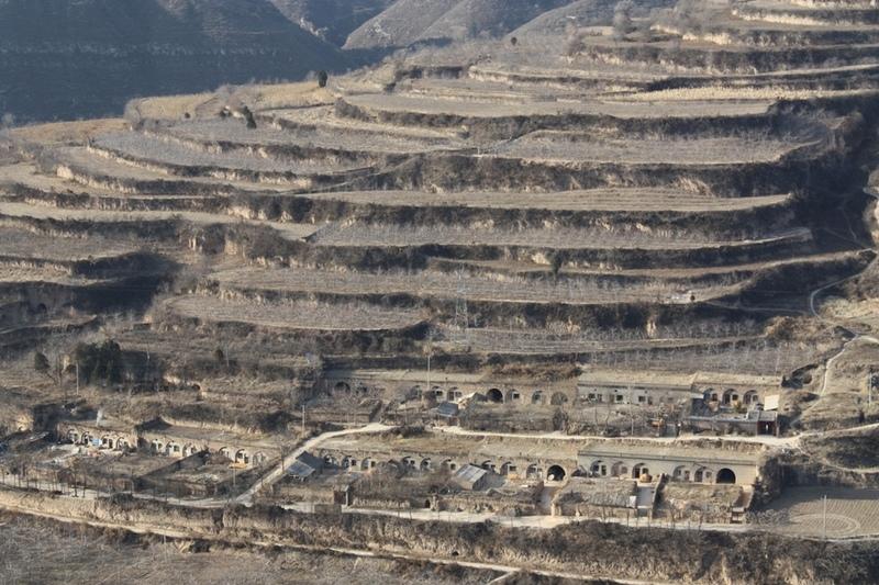
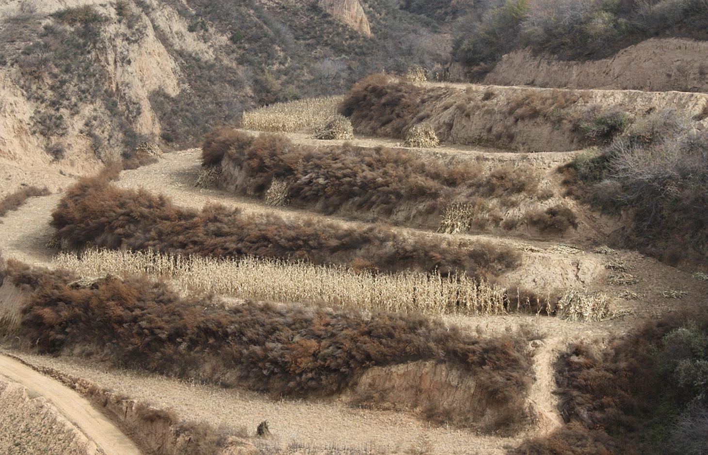
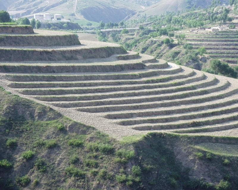
A terrace is a leveled section of a hilly cultivated area, designed as a method of soil conservation to slow or prevent the rapid surface runoff and erosion of topsoil. Often such land is formed into multiple terraces, giving a stepped appearance.
Purpose of the Technology: To change the landform for better agricultural condition of operation of tillage and harvasting, reduction of soil erosion and water loss and finally for higher production.
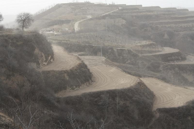
Establishment / maintenance activities and inputs: The building of a terrace in the loess plateau takes long because loess is very soft and deep and the severe soil erosion and shortage of water in agriculture hinders the process, as well. Previously, terraces were constructed by hand. These terraces weres narrow and damaged by the great storms. Now, the machinery is used to build wide terrace with high bank size in the loess plateau. The establishment of terrace needs a lot of money but it is a long-term investment. The maintenance of terrace is considerable economic because the major efforts are the annually improvment of terrace bunds.
Natural / human environment: The soil erosion is very severe because of the cohesionless loess soil and very intensive rainfall storms in the summer and autumn that would destroy the land surface into broken hilly area. Terrace is a kind of measure to resolve it combining with crops. The human activities here is very intensive because they must plant on the slopes that would make the soil erosion greater.
2.3 Fotos da tecnologia
Galeria de Mídias
2.5 País/região/locais onde a tecnologia foi aplicada e que estão cobertos nesta avaliação
País:
China
Região/Estado/Província:
Shaanxi Province
Especificação adicional de localização:
Yanhe River Basin
Especifique a difusão da tecnologia:
- Uniformemente difundida numa área
Se a Tecnologia estiver uniformemente distribuída por uma área, especifique a área coberta (em km2):
253,3
Comentários:
Total area covered by the SLM Technology is 253.3 km2.
The total area with different measures is till to 2000. Yanhe River is a first class branch of Yellow River, China. The average channel slope is 3.26‰, and the area of whole basin is 7,687 km2. It is in the semi-arid North Temperate Zone with an average annual precipitation varying from 500 to 550 mm, and an average annual air temperature ranging from 8.5 to 11.4℃. It is in hilly gully area of the Loess Plateau covered by loess. The landform is seriously broken by cutting gullies induced by water erosion. The gully density (the length of channel in one km2) is amount to 2.1 to 4.6 km•km-2. The soil loss is severe all along.
The Ganguyi Hydrology Station (109°48′E, 36°42′N) located in the Ganguyi Town, Baota Country, Yan’an City, Shaanxi Province. The area up Ganguyi Hydrology Station is 5,891 km2, including of Jingbian County(256km2), Zhidan County(708km2), Ansai County(2,699km2) and Baota County(2,228km2). The average annual runoff is 0.22 billion m3, and the runoff modulus accounting for 4,776.36 m3•km-2•yr-1. The average annual sediment flow is 4.776
Map
×2.6 Data da implementação
Caso o ano exato seja desconhecido, indique a data aproximada:
- mais de 50 anos atrás (tradicional)
2.7 Introdução da tecnologia
Especifique como a tecnologia foi introduzida:
- Como parte do sistema tradicional (>50 anos)
Comentários (tipos de projeto, etc.):
The terrace in this site has been formed since 1994 with machinery. The land is quite wide and large enough for agriculture in the hilly loess region,
3. Classificação da tecnologia de GST
3.1 Principal/principais finalidade(s) da tecnologia
- Reduz, previne, recupera a degradação do solo
3.2 Tipo(s) atualizado(s) de uso da terra onde a tecnologia foi aplicada
Uso do solo misturado dentro da mesma unidade de terra:
Sim
Especificar o uso misto da terra (culturas/ pastoreio/ árvores):
- Agrofloresta

Terra de cultivo
- Cultura anual
- Cultura perene (não lenhosa)
- Cultura de árvores e arbustos
Cultivo anual - Especificar culturas:
- cereais - milho
- cereais - painço
- culturas de flores
- culturas forrageiras - alfalfa
- Legumes e leguminosas - feijão
- culturas oleaginosas - girassol, colza, outros
- culturas de raiz/tubérculos- batatas
- legumes - outros
Cultivo de árvores e arbustos - Especificar culturas:
- datas
- frutas de pomóideas (maçãs, peras, marmelos, etc.)
Número de estações de cultivo por ano:
- 1
Especifique:
Longest growing period in days: 300Longest growing period from month to month: March to NovemberSecond longest growing period in days: 200Second longest growing period from month to month: April to October
Comentários:
Main cash crops: Beans, sunflower, apple, Chinese date, alfalfa
Main food crops: Potato, millets, maize, buckwheat
other crops: vegetable
Major land use problems (compiler’s opinion): Soil and water losses are alarming in this region. The loose loess, steep slopes, and intensive storms in the summer and autumn, accelerates this process. Aditionally, the lack of rainfall negatively impacts agriculture and vegatation. Sediment deposition could increase the river bed and diminish capacity of reservoirs. On one hand side floods occur frequently because of fast and large runoff and on other hand side sedimentation in rivers reduce their water carring capacity.
Major land use problems (land users’ perception): The low yield of crops and the low income from land is more important for the local people. It is necessary to improve the agricultural conditions. The land, especially the tableland and gentle slope land could be convert into terrace.
Future (final) land use (after implementation of SLM Technology): Cropland: Ca: Annual cropping
Type of cropping system and major crops comments: The composation of agriculture is very simple here.
Livestock is grazing on crop residues
3.3 O uso do solo mudou devido à implementação da Tecnologia?
O uso do solo mudou devido à implementação da Tecnologia?
- Sim (Por favor, preencha as perguntas abaixo com relação ao uso do solo antes da implementação da Tecnologia)

Pastagem
- Intensive grazing/ fodder production
3.4 Abastecimento de água
Abastecimento de água para a terra na qual a tecnologia é aplicada:
- Precipitação natural
3.5 Grupo de GST ao qual pertence a tecnologia
- Medidas de curva de nível
3.6 Medidas de GST contendo a tecnologia

Medidas vegetativas
- V2: gramíneas e plantas herbáceas perenes

Medidas estruturais
- S1: Terraços

Medidas de gestão
- M1: Mudança no tipo de uso da terra
Comentários:
Main measures: structural measures
Secondary measures: vegetative measures, management measures
Type of vegetative measures: aligned: -along boundary
3.7 Principais tipos de degradação da terra abordados pela tecnologia

Erosão do solo pela água
- Wt: Perda do solo superficial/erosão de superfície

Degradação da água
- Hs: mudança na quantidade de água de superfície
- Hw: redução da capacidade de tamponamento de zonas úmidas
Comentários:
Main type of degradation addressed: Wt: loss of topsoil / surface erosion
Secondary types of degradation addressed: Hs: change in quantity of surface water, Hw: reduction of the buffering capacity of wetland areas
Main causes of degradation: deforestation / removal of natural vegetation (incl. forest fires) (The natural vegetation in this region is grass on theslope and trees on the gully and alluvial land. After the destroy of natural, the soil loss increases greatly.), Heavy / extreme rainfall (intensity/amounts) (About 70% of annual rainfall is in the summer and autumn. The storm is very intensive.), population pressure (The population density account for 71 capita per square km.)
Secondary causes of degradation: droughts (The rainfall varies greatly in different year and different seasons. The drought happened frenquently.)
3.8 Redução, prevenção ou recuperação da degradação do solo
Especifique o objetivo da tecnologia em relação a degradação da terra:
- Reduzir a degradação do solo
Comentários:
Main goals: mitigation / reduction of land degradation
4. Especificações técnicas, implementação de atividades, entradas e custos
4.1 Desenho técnico da tecnologia
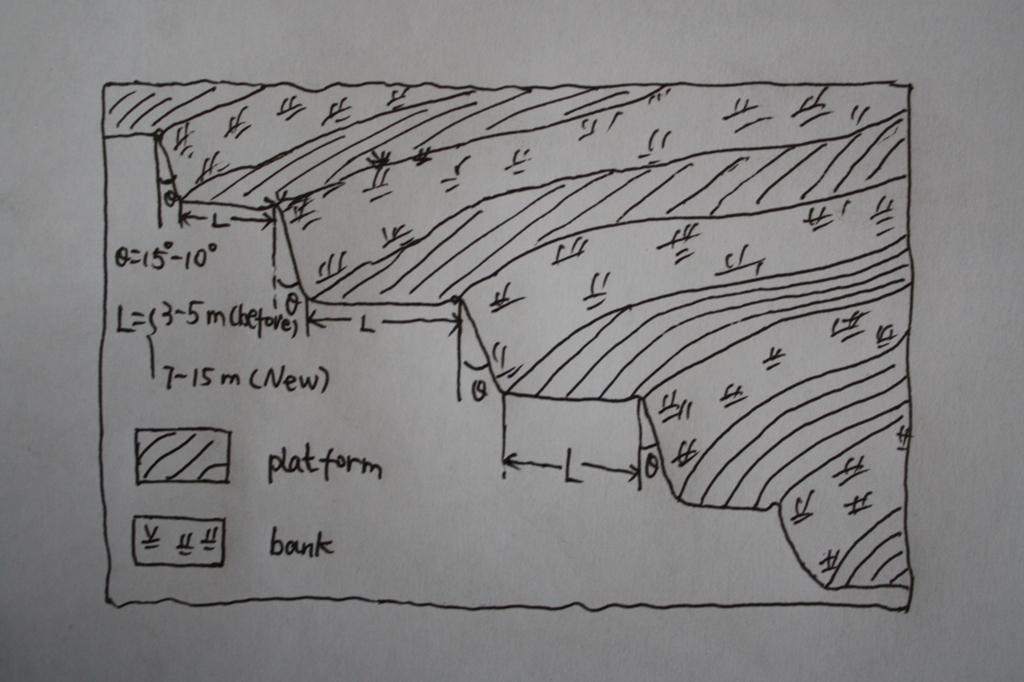
Especificações técnicas (relacionada ao desenho técnico):
The brief structure of terrace in the Yanhe River Basin.
Location: Zhifanggou Watershed. Ansai County, Shaanxi, China
Date: 2008-12-15
Technical knowledge required for field staff / advisors: low (The location selection and how to build a good terrace need special knowledge on soil engineering.)
Technical knowledge required for land users: moderate (It is easy to know the benefit for all the local farmers.)
Main technical functions: control of concentrated runoff: retain / trap, reduction of slope angle, increase of infiltration
Secondary technical functions: increase / maintain water stored in soil, improvement of water quality, buffering / filtering water, increase of biomass (quantity)
Aligned: -along boundary
Vegetative material: G : grass
Number of plants per (ha): 50000
Vertical interval between rows / strips / blocks (m): 2.5
Spacing between rows / strips / blocks (m): 0.5
Grass species: Natural grass to protect the bank of terrace.
Slope (which determines the spacing indicated above): 20.00%
If the original slope has changed as a result of the Technology, the slope today is (see figure below): 2.00%
Gradient along the rows / strips: 1.00%
Terrace: bench level
Vertical interval between structures (m): 2.5
Spacing between structures (m): 8
Height of bunds/banks/others (m): 2.5
Width of bunds/banks/others (m): 8
Length of bunds/banks/others (m): 50-100
Construction material (earth): The terrace in the Loess Plateau are used local soil/earth directly.
Slope (which determines the spacing indicated above): 30%
If the original slope has changed as a result of the Technology, the slope today is: 30-60%
Lateral gradient along the structure: 2%
Vegetation is used for stabilisation of structures.
Change of land use type: Wild grassland or range land before mostly. Some time the cropland on the slope.
Change of land use practices / intensity level: The labor is less intensive on the plain platform.
Autor:
Wang Fei, Yangling, Shaanxi, China
4.2 Informação geral em relação ao cálculo de entradas e custos
Especifique a moeda utilizada para os cálculos de custo:
- USD
Se for relevante, indique a taxa de câmbio do USD para moeda local (por exemplo, 1 USD = 79,9 Real): 1 USD =:
0,83
Indique a média salarial da mão-de-obra contratada por dia:
8.8
4.3 Atividades de implantação
| Atividade | Periodicidade (estação do ano) | |
|---|---|---|
| 1. | Survey and design | Before construction |
| 2. | Move the topsoil to other place | 1st step of construction |
| 3. | Built the platform and bank with soil digged | 2nd step of construction |
| 4. | Backcover the topsoil on the surface of platform | 3rd step of construction |
| 5. | Check and accept the terrace | After the terrace finished |
4.4 Custos e entradas necessárias para a implantação
| Especifique a entrada | Unidade | Quantidade | Custos por unidade | Custos totais por entrada | % dos custos arcados pelos usuários da terra | |
|---|---|---|---|---|---|---|
| Mão-de-obra | Survey and design | Person/day | 45,0 | 8,8 | 396,0 | 100,0 |
| Mão-de-obra | Building terraces (machine price included) | Person/day | 75,0 | 19,0 | 1425,0 | 100,0 |
| Custos totais para a implantação da tecnologia | 1821,0 | |||||
| Custos totais para o estabelecimento da Tecnologia em USD | 2193,98 | |||||
Comentários:
Duration of establishment phase: 0.5 month(s)
4.5 Atividades recorrentes/manutenção
| Atividade | Periodicidade/frequência | |
|---|---|---|
| 1. | Reinforce the bank | annually |
| 2. | Fill the erosion hole of the landform | annually |
| 3. | Build the edge in some terraces | annually |
| 4. | Reinforce the bank | annually |
| 5. | Fill the erosion hole of the landform | annually |
| 6. | Build the edge in some terraces | annually |
4.6 Custos e entradas necessárias pata a manutenção/atividades recorrentes (por ano)
| Especifique a entrada | Unidade | Quantidade | Custos por unidade | Custos totais por entrada | % dos custos arcados pelos usuários da terra | |
|---|---|---|---|---|---|---|
| Mão-de-obra | Keep Terraces in shape | Person/day | 30,0 | 8,8 | 264,0 | 100,0 |
| Custos totais para a manutenção da tecnologia | 264,0 | |||||
| Custos totais de manutenção da Tecnologia em USD | 318,07 | |||||
Comentários:
Machinery/ tools: Crawl dozer and small traditional hand tool., crawler tractor, spade
In general condition, slope and soil, in the middle reaches of Yan River Basin. The prices of labour-day and Machine-hour are around 2005.
4.7 Fatores mais importantes que afetam os custos
Descreva os fatores mais determinantes que afetam os custos:
The terrace on the steep slope need more input for more soil and earth should be moved. It is the most important factor.The soil depth is not so important for the deep soil layer here.The cost of labour increases greatly in the last several years and the cost of construction of terrace increased.
5. Ambiente natural e humano
5.1 Clima
Precipitação pluviométrica anual
- <250 mm
- 251-500 mm
- 501-750 mm
- 751-1.000 mm
- 1.001-1.500 mm
- 1.501-2.000 mm
- 2.001-3.000 mm
- 3.001-4.000 mm
- > 4.000 mm
Especificações/comentários sobre a pluviosidade:
The mean annual rainfall in the basin is 515.2 mm in the duration from 1952 to 2000. The rainfall from May to Oct accounts for 446.8 mm, up to 86.7%; and that from Jun to Sep accounts for 367.6 mm, up
Zona agroclimática
- Semiárido
Thermal climate class: temperate. The accumulating time that temperature above 0 ℃ about 3800 hours, and that above 10 ℃ is more than 3200 hours.
5.2 Topografia
Declividade média:
- Plano (0-2%)
- Suave ondulado (3-5%)
- Ondulado (6-10%)
- Moderadamente ondulado (11-15%)
- Forte ondulado (16-30%)
- Montanhoso (31-60%)
- Escarpado (>60%)
Formas de relevo:
- Planalto/planície
- Cumes
- Encosta de serra
- Encosta de morro
- Sopés
- Fundos de vale
Zona de altitude:
- 0-100 m s.n.m.
- 101-500 m s.n.m.
- 501-1.000 m s.n.m.
- 1.001-1.500 m s.n.m.
- 1.501-2.000 m s.n.m.
- 2.001-2.500 m s.n.m.
- 2.501-3.000 m s.n.m.
- 3.001-4.000 m s.n.m.
- > 4.000 m s.n.m.
Indique se a tecnologia é aplicada especificamente em:
- Posições convexas
Comentários e outras especificações sobre a topografia:
Landforms also: mountain slopes and hill slopes
Slopes on average also very steep
5.3 Solos
Profundidade do solo em média:
- Muito raso (0-20 cm)
- Raso (21-50 cm)
- Moderadamente profundo (51-80 cm)
- Profundo (81-120 cm)
- Muito profundo (>120 cm)
Textura do solo (solo superficial):
- Médio (limoso, siltoso)
Matéria orgânica do solo superficial:
- Baixo (<1%)
Caso disponível anexe a descrição completa do solo ou especifique as informações disponíveis, p. ex. tipo de solo, PH/acidez do solo, nitrogênio, capacidade de troca catiônica, salinidade, etc.
Soil texture: There are more than 50% soil particle are fine sand with size between 0.05 and 0.1 mm.
Soil fertility very low: Lack of N, P and SOM.
Topsoil organic matter: The average Top-SOM of cropland is about 0.05%
Soil drainage / infiltration good: The inflitration of Loess is very fast, but it is prone to sealing when flashing.
Soil water storage capacity low: It is easy to evaporation and drainage.
5.4 Disponibilidade e qualidade de água
Lençol freático:
5-50 m
Disponibilidade de água de superfície:
Médio
Qualidade da água (não tratada):
Água potável precária (tratamento necessário)
Comentários e outras especificações sobre a qualidade e a quantidade da água:
Availability of surface water medium: It is very stable in this region.
Availability of surface water also poor/none: Nearly all the branches of Yanhe are seasonal river.
Ground water table: It depends on the landform. In valley and alluvial land, it is shallow.
Water quality: Good quality for there are few pollution sources.
5.5 Biodiversidade
Diversidade de espécies:
- Médio
Comentários e outras especificações sobre biodiversidade:
It is very stable in this region.
5.6 Características dos usuários da terra que utilizam a tecnologia
Orientação de mercado do sistema de produção:
- misto (subsistência/comercial)
- Comercial/mercado
Rendimento não agrícola:
- 10-50% de toda renda
Nível relativo de riqueza:
- Média
Indivíduos ou grupos:
- Indivíduo/unidade familiar
Nível de mecanização:
- Trabalho manual
- Tração animal
Gênero:
- Mulheres
- Homens
Indique outras características relevantes dos usuários da terra:
Land users applying the Technology are mainly common / average land users
Difference in the involvement of women and men: No clear difference.
Population density: 50-100 persons/km2
Annual population growth: < 0.5%
80% of the land users are average wealthy (The terrace are build together in some villages for all the people funded by national subsidy.).
Off-farm income specification: The yield of terrace is much high and stable.
Level of mechanization manual work: The harvesting and other management are by hand, even the tillage on the nerrow terrace
Level of mechanization animal traction: Tillage with animal power mostly in the wider terrace.
Market orientation mixed subsistence/ commercial: Some production for themselves, but most of production is exchanged on the market.
5.7 Área média de terrenos utilizados pelos usuários de terrenos que aplicam a Tecnologia
- < 0,5 ha
- 0,5-1 ha
- 1-2 ha
- 2-5 ha
- 5-15 ha
- 15-50 ha
- 50-100 ha
- 100-500 ha
- 500-1.000 ha
- 1.000-10.000 ha
- > 10.000 ha
É considerado pequena, média ou grande escala (referente ao contexto local)?
- Pequena escala
Comentários:
According to 0.054 ha per capita.
5.8 Propriedade de terra, direitos de uso da terra e de uso da água
Propriedade da terra:
- Estado
- Comunitário/rural
Direitos do uso da terra:
- Indivíduo
Direitos do uso da água:
- Acesso livre (não organizado)
Comentários:
Like other rural area in China.
5.9 Acesso a serviços e infraestrutura
Saúde:
- Pobre
- Moderado
- Bom
Educação:
- Pobre
- Moderado
- Bom
Emprego (p. ex. não agrícola):
- Pobre
- Moderado
- Bom
Vias e transporte:
- Pobre
- Moderado
- Bom
Água potável e saneamento:
- Pobre
- Moderado
- Bom
Serviços financeiros:
- Pobre
- Moderado
- Bom
6. Impactos e declarações finais
6.1 Impactos no local mostrados pela tecnologia
Impactos socioeconômicos
Produção
Produção agrícola
Quantidade anterior à GST:
600
Quantidade posterior à GST:
2200
Produção animal
Produção de madeira
Risco de falha de produção
Diversidade de produtos
Área de produção
Disponibilidade e qualidade de água
Disponibilidade de água potável
Qualidade da água potável
Renda e custos
Rendimento agrícola
Quantidade anterior à GST:
43.9
Quantidade posterior à GST:
120
Diversidade de fontes de rendimento
Carga de trabalho
Impactos socioculturais
Segurança alimentar/auto-suficiência
Atenuação de conflitos
Livelihoods and human well-being
Impactos ecológicos
Ciclo hídrico/escoamento
Colheita/recolhimento de água
Escoamento superficial
Evaporação
Comentários/especificar:
Evaporation form the wall of terrace, Especially for the narrow terrace
Solo
Umidade do solo
Comentários/especificar:
More inflitration of rainfall, but the evaporation near to the wall increases
Cobertura do solo
Perda de solo
Quantidade anterior à GST:
10000t/km^
Quantidade posterior à GST:
2000t/km^2
Biodiversidade: vegetação, animais
Biomassa/carbono acima do solo
Diversidade vegetal
Outros impactos ecológicos
Hazards towards adverse events
6.2 Impactos externos mostrados pela tecnologia
Caudal confiável e estável em período seco
Cheias de jusante
Sedimentação a jusante
Capacidade de tamponamento/filtragem
Sedimentos transportados pelo vento
Danos em áreas vizinhas
Danos na infraestrutura pública/privada
6.3 Exposição e sensibilidade da tecnologia às mudanças climáticas graduais e extremos/desastres relacionados ao clima (conforme o ponto de vista dos usuários da terra)
Mudança climática gradual
Mudança climática gradual
| Estação do ano | aumento ou diminuição | Como a tecnologia lida com isso? | |
|---|---|---|---|
| Temperatura anual | aumento | bem |
Extremos (desastres) relacionados ao clima
Desastres meteorológicos
| Como a tecnologia lida com isso? | |
|---|---|
| Temporal local | não bem |
| Tempestade de vento local | bem |
Desastres climatológicos
| Como a tecnologia lida com isso? | |
|---|---|
| Seca | não conhecido |
Desastres hidrológicos
| Como a tecnologia lida com isso? | |
|---|---|
| Inundação geral (rio) | bem |
Outras consequências relacionadas ao clima
Outras consequências relacionadas ao clima
| Como a tecnologia lida com isso? | |
|---|---|
| Período de crescimento reduzido | não conhecido |
Comentários:
Loess is very prone to erosion and extreme storms would destory the bank of terrace. In the study site sesonal rainfall increased and the loess terrace could retain more soil water and reduce the runoff.
6.4 Análise do custo-benefício
Como os benefícios se comparam aos custos de implantação (do ponto de vista dos usuários da terra)?
Retornos a curto prazo:
levemente positivo
Retornos a longo prazo:
positivo
Como os benefícios se comparam aos custos recorrentes/de manutenção(do ponto de vista dos usuários da terra)?
Retornos a curto prazo:
levemente positivo
Retornos a longo prazo:
muito positivo
Comentários:
The yield of terrace is stable and relative higher. The income from terrace is high and the maintain cost is low.
6.5 Adoção da tecnologia
- 1-10%
Se disponível, determine a quantidade (número de unidades familiares e/ou área abordada):
100 households
De todos aqueles que adotaram a Tecnologia, quantos o fizeram espontaneamente, ou seja, sem receber nenhum incentivo/ pagamento material?
- 0-10%
Comentários:
90% of land user families have adopted the Technology with external material support
95 land user families have adopted the Technology with external material support
Comments on acceptance with external material support: Most land farmers have some terrace. I do not know the exact number of land user families who adopted the technology.
10% of land user families have adopted the Technology without any external material support
5 land user families have adopted the Technology without any external material support
Comments on spontaneous adoption: the old narrow terraces, now a very small area left, are build voluntarily.
There is a strong trend towards spontaneous adoption of the Technology
Comments on adoption trend: Nearly all the people know the benefit of terrace. the benefits of terraces are very good for crops and orchards are high enough in this region.
6.7 Pontos fortes/vantagens/oportunidades da tecnologia
| Pontos fortes/vantagens/oportunidades na visão do usuário da terra |
|---|
|
Increase yield and income. How can they be sustained / enhanced? If the terrace is maintained well, the water condition would be better than that on the slope land even in dry year with low precipitation. |
|
Convenient to till and harvest How can they be sustained / enhanced? Tillage and harvesting is much easier on the plain flat land than on the slope. The maintainance of terrace is important. |
| Pontos fortes/vantagens/oportunidades na visão do compilador ou de outra pessoa capacitada |
|---|
|
Reduce soil erosion on the slope. How can they be sustained / enhanced? The loess soil is prone to erosion because of its loose character induced by fine sand content and low soil organic matter. The plain flat makes the dispersion and transportation of soil particls difficult. |
|
Reduce runoff and increase the soil moisture How can they be sustained / enhanced? The runoff generation is smaller on the plain than on the slope. Slow movement of surface water lead to more soil infiltration. |
|
Increase yield. How can they be sustained / enhanced? Water is the limit factor in the loess plateau. The yield would increase if there is enough water available. |
|
Decrease flood risk. How can they be sustained / enhanced? It is a kind of off-site benefits because less runoff generation and gentle process of runoff decrease flooding. Reduction of sediment also diminish flood risk because the drainage capacity of channel and adjusting capacity of reservior increase when sedimentation decrease. |
6.8 Pontos fracos, desvantagens/riscos da tecnologia e formas de superá-los
| Pontos fracos/desvantagens/riscos na visão do usuário da terra | Como eles podem ser superados? |
|---|---|
| The output is also low in contrast with other industries. | No way to overcome it. The total and net income is too low because the area of terrace per capita is very small. |
| The income is relative compared with other industries. | No way to overcome it. The net income is low because the labour costs are increasing, and the total income because labour cost and very small area of terrace per capita. |
| Pontos fracos/vantagens/riscos na visão do compilador ou de outra pessoa capacitada | Como eles podem ser superados? |
|---|---|
| There is possible damage of terraces because the loess is very loosen and prone to collapse. | Keep upmaintaining the bank and land well. |
| Decrease runoff of lower stream. | No way to overcome it, but it also could decrease the risk of floods. |
7. Referências e links
7.1 Métodos/fontes de informação
7.2 Referências às publicações disponíveis
Título, autor, ano, ISBN:
Soil and water conservation records of Shaanxi Province. 2000. Shaanxi People's Press, Xi'an City, China
Disponível de onde? Custos?
Library of ISWC, CAS
Título, autor, ano, ISBN:
The soil and agriculture of the Loess Plateau. 1989. Zhu Xianmo, Agriculture Press, Beijing City, China
Disponível de onde? Custos?
Library of ISWC, CAS
Título, autor, ano, ISBN:
Statistical tearbook of Yan'an. 2003. Compiled by Editorial Board of Statistical tearbook of Yan'an
Disponível de onde? Custos?
Library of ISWC, CAS
Título, autor, ano, ISBN:
Impact of human activities on runoff and sediment change of Yanhe River based on the periods divided by sediment concentration. 2008. WANG Fei , MU Xing-min ,JIAO Ju-ying, LI Rui. Journal of Sediment Research
Disponível de onde? Custos?
http://159.226.100.28/asp/Detail.asp
Título, autor, ano, ISBN:
Changes of soil erosion intensity due to conversion of farmland to forest and grassland in Yanhe River. 2007. BasinWang Bangwen, yang Qinke, Liu Zhihong, Meng Qingxiang, Science of Soil and Water Conservation
Disponível de onde? Custos?
http://159.226.100.28/asp/Detail.asp
Links e módulos
Expandir tudo Recolher tudoLinks
Não há links
Módulos
Não há módulos