Stonelines [Quênia]
- Criação:
- Atualização:
- Compilador/a: Paul Kahiga
- Editor: –
- Revisores: David Streiff, Alexandra Gavilano
Miraini ya maviga
technologies_1581 - Quênia
Veja as seções
Expandir tudo Recolher tudo1. Informação geral
1.2 Detalhes do contato das pessoas capacitadas e instituições envolvidas na avaliação e documentação da tecnologia
Especialista em GST:
Mwangi Gathenya
JKUAT
Quênia
Especialista em GST:
Home Patrick
JKUAT
Quênia
Especialista em GST:
Wamuongo Jane
KARI
Quênia
Especialista em GST:
Namirembe Sara
ICRAF
Quênia
Especialista em GST:
Chege Timothy
JKUAT
Quênia
Especialista em GST:
Karanja Andrew
KARI
Quênia
Nome da(s) instituição(ões) que facilitou(ram) a documentação/ avaliação da Tecnologia (se relevante)
International Centre for Research in Agroforestry (ICRAF) - QuêniaNome da(s) instituição(ões) que facilitou(ram) a documentação/ avaliação da Tecnologia (se relevante)
KARI Headquarters (KARI Headquarters) - QuêniaNome da(s) instituição(ões) que facilitou(ram) a documentação/ avaliação da Tecnologia (se relevante)
Jomo Kenyatta University (Jomo Kenyatta University) - Quênia1.3 Condições em relação ao uso da informação documentada através de WOCAT
O compilador e a(s) pessoa(s) capacitada(s) aceitam as condições relativas ao uso de dados documentados através do WOCAT:
Sim
2. Descrição da tecnologia de GST
2.1 Descrição curta da tecnologia
Definição da tecnologia:
Stonelines are constructed along the contours to slow down the speed of runoff, filter the soil and enhance water infiltration.
2.2 Descrição detalhada da tecnologia
Descrição:
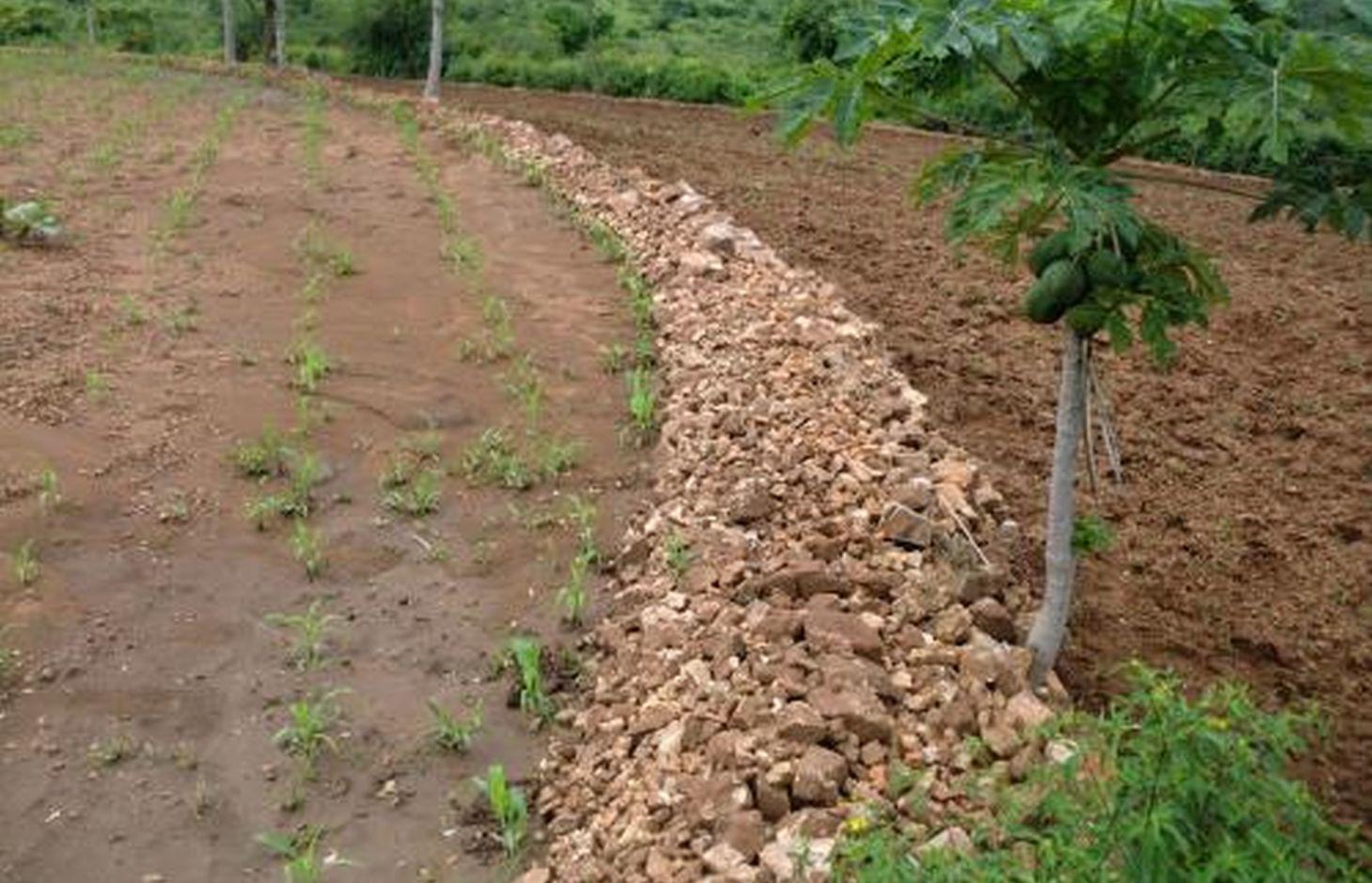
In Kenya stone lines are mostly practiced in areas that receive 200-750 mm of annual rainfall with a spacing of 15-30 m between them. They are particularly common in areas where rocks are readily available, such as Mbeere, Laikipia, Baringo, Mwingi, Kitui and Tharaka. Since the stonelines are permeable they do not pond runoff water but instead, they slow down the speed, filter it and spread the water over the field, thus enhancing water infiltration and reducing soil erosion. They are built in series running along the slope. In addition, the stone barrier blocks and settles down the sediments transported from the upper slopes.
Purpose of the Technology: They are often used to rehabilitate eroded and abandoned land. The advantages of stonelines include; slowing down the runoff thereby increasing infiltration and soil moisture. They also induce a natural process of terracing, reducing erosion and rehabilitation of eroded lands by trapping silt. They are easy to design and construct and since the stone line structure is permeable there is no need for construction of spillways to drain the excess runoff water. When it rains, the soil builds up on the upslope side of the stonelines and over time a natural terrace is formed.
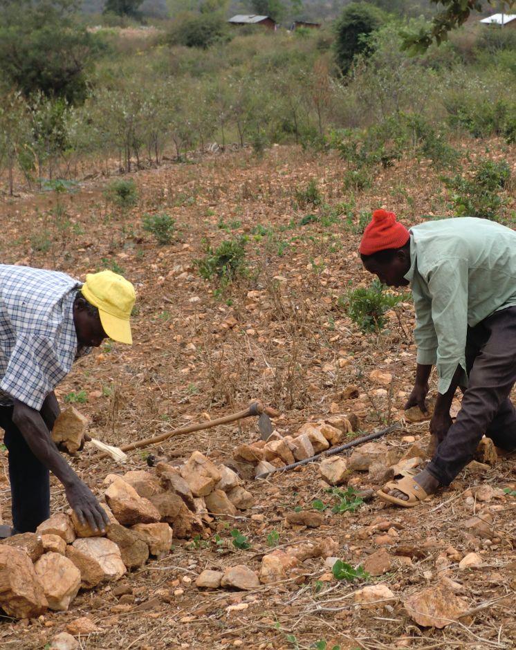
Establishment / maintenance activities and inputs: The stonelines are spaced 15-30 m apart, a shorter distance being used for the steeper slopes. Stonelines are normally suitable on gentle slopes. Slopes above 35% should be avoided. They are established in the following manner: first, the contour line are marked out with the help of a tube level or line levels. In this region here, it is done with the help of the frontline agricultural extension officers. Secondly, a shallow foundation trench is dug across the slope (5-10 cm to 30 cm deep) using basic farm equipments (jembes or hoes). As shown on the above photographs, the larger stones are put on the down slope side of the trench while the smaller stones are used to build the rest of the bund. The smallest stones are used to fill the gaps and increase the heights of the bunds up to the desired level. Farmers plant fruit trees (pawpaws) as show in the photograph above on the upper part. The trees utilises the moisture and rich sediments deposited on the upper part. The stonelines can be reinforced with earth, or crop residues to make them more stable. Maintenance of stonelines is done by repairing the already damaged /fallen stoneline that may have been knocked down or disarranged by livestock or by human beings. In this case animal access needs to be limited and/or the bund should be laid out in a way that allows the animals to pass through.
Natural / human environment: In the lower Mbeere South District where the stoneline technologies is largely practiced, unless there are stones in the individual farms, it might be difficult to import stones from other farms as the exercise can be labor intensive. In this catchment, the Ministry of Agriculture through the front line extension officers has taken a lead role in encouraging farmers to adopt the technology especially the farms which have many stones. Most of the farmers who have implemented this technology in the Lower Mbeere South District learn from the ones who are already practicing through field days or individual initiatives.
2.3 Fotos da tecnologia
Galeria de Mídias
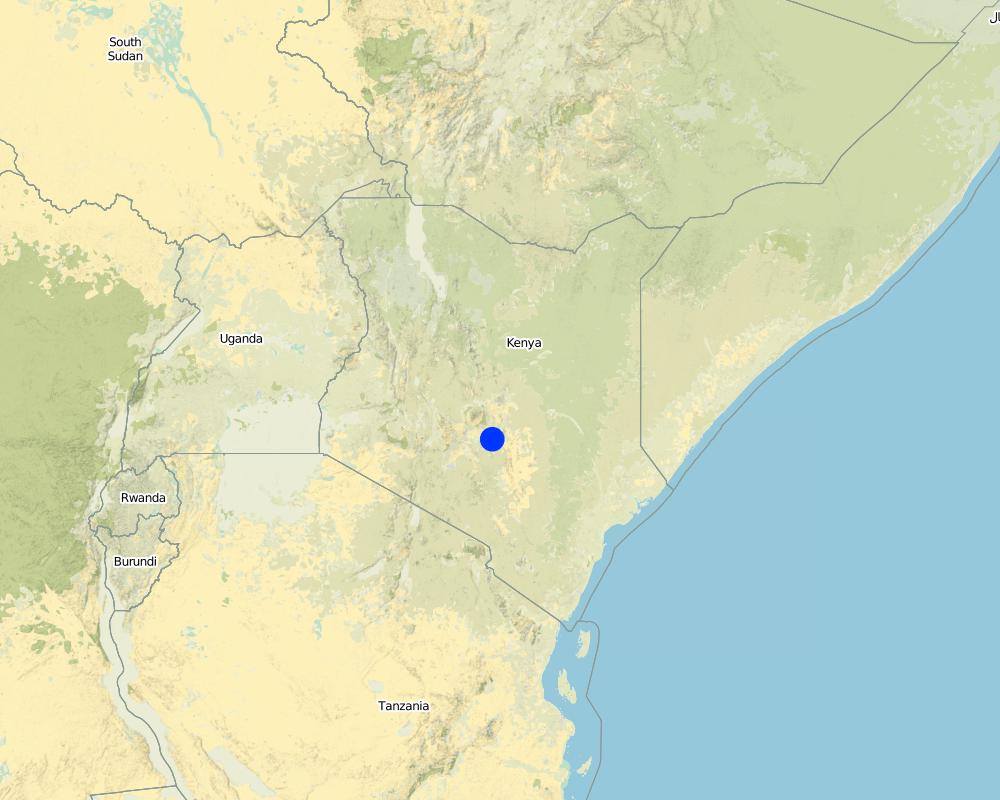
2.5 País/região/locais onde a tecnologia foi aplicada e que estão cobertos nesta avaliação
País:
Quênia
Região/Estado/Província:
Eastern Province
Especificação adicional de localização:
Mbeere South District
Especifique a difusão da tecnologia:
- Uniformemente difundida numa área
Se a área precisa não for conhecida, indicar a área aproximada coberta:
- < 0,1 km2 (10 ha)
Comentários:
Not many farmers are practicing stonelines, the farmers who are practicing are copying from some successful farmers within their neighborhood. They also corroborate with the local agricultural extension officers from the Ministry of Agriculture (MoA) to show them how to construct the stonelines along the contours.
Map
×2.6 Data da implementação
Caso o ano exato seja desconhecido, indique a data aproximada:
- 10-50 anos atrás
2.7 Introdução da tecnologia
Especifique como a tecnologia foi introduzida:
- atráves de inovação dos usuários da terra
Comentários (tipos de projeto, etc.):
The land had too many stones which inhibited operations. By removing the stones, the farmer placed them in line along the contour.
3. Classificação da tecnologia de GST
3.1 Principal/principais finalidade(s) da tecnologia
- Reduz, previne, recupera a degradação do solo
3.2 Tipo(s) atualizado(s) de uso da terra onde a tecnologia foi aplicada

Terra de cultivo
- Cultura anual
- Cultura perene (não lenhosa)
- Cultura de árvores e arbustos
Cultivo anual - Especificar culturas:
- cereais - milho
- cereais - painço
- cereais - sorgo
- legumes e leguminosas - ervilhas
Cultivo de árvores e arbustos - Especificar culturas:
- manga, mangostão, goiaba
- frutas de pomóideas (maçãs, peras, marmelos, etc.)
Número de estações de cultivo por ano:
- 2
Especifique:
Longest growing period in days: 90 Longest growing period from month to month: March-May Second longest growing period in days: 90 Second longest growing period from month to month: October - December
Comentários:
Major crop: Sorghum, maize, mangoes, pawpaws, miraa, millet, cowpeas
Major land use problems (compiler’s opinion): Limited cultivation land due to hindrances that are brought about by the scattered stones on the land's surface.
Major land use problems (land users’ perception): Soil erosion because of lack of soil and water conservation structures that leads to low land productivity.
Future (final) land use (after implementation of SLM Technology): Cropland: Ca: Annual cropping
3.3 O uso do solo mudou devido à implementação da Tecnologia?
O uso do solo mudou devido à implementação da Tecnologia?
- Sim (Por favor, preencha as perguntas abaixo com relação ao uso do solo antes da implementação da Tecnologia)
Terra de cultivo
- Cultura de árvores e arbustos
3.4 Abastecimento de água
Abastecimento de água para a terra na qual a tecnologia é aplicada:
- Precipitação natural
3.5 Grupo de GST ao qual pertence a tecnologia
- Desvio e drenagem de água
3.6 Medidas de GST contendo a tecnologia

Medidas estruturais
- S2: Barragens, bancos
3.7 Principais tipos de degradação da terra abordados pela tecnologia

Erosão do solo pela água
- Wt: Perda do solo superficial/erosão de superfície
Comentários:
Main type of degradation addressed: Wt: loss of topsoil / surface erosion
Main causes of degradation: soil management, Heavy / extreme rainfall (intensity/amounts), poverty / wealth, labour availability (Construction of the technology is labour intensive)
Secondary causes of degradation: deforestation / removal of natural vegetation (incl. forest fires)
3.8 Redução, prevenção ou recuperação da degradação do solo
Especifique o objetivo da tecnologia em relação a degradação da terra:
- Prevenir degradação do solo
- Recuperar/reabilitar solo severamente degradado
Comentários:
Secondary goals: mitigation / reduction of land degradation
4. Especificações técnicas, implementação de atividades, entradas e custos
4.1 Desenho técnico da tecnologia
Especificações técnicas (relacionada ao desenho técnico):
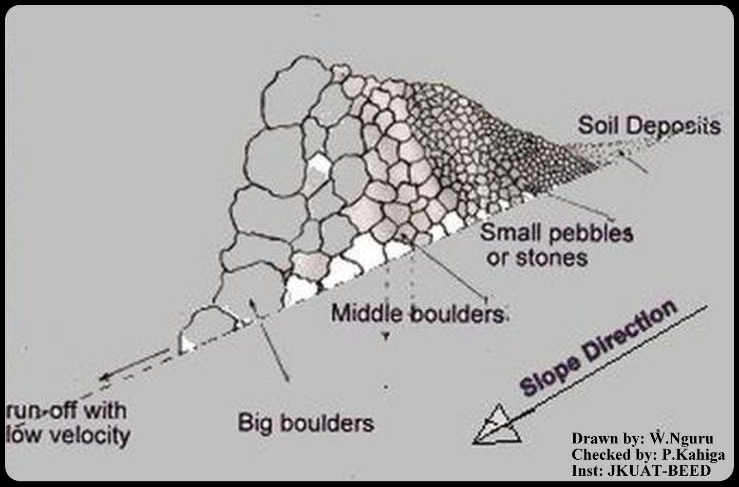
This is a technical drawing representing a cross-section view of how the stonelines are constructed by the emerging farmers in the lower Mbeere South District.
First, a small trench is dug along an established contour line, the farmer starts arranging the stones with reference to their sizes. The bigger ones are arranged on the lower side and the small ones on the upper side as shown on the technical drawing.
By so doing, the eroded soils are trapped on the upper side by the small pebbles, allowing the water to pass through at lower speed hence low erosive capacity.
Location: Ntharawe. Lower Mbeere South District
Date: 2011-08-02
Technical knowledge required for field staff / advisors: moderate (In order to implement this technology, the farmers contact the front line agricultural extension officer in order to assist in making the contours.)
Technical knowledge required for land users: high (Stone required placement of a certain order. Big stone on the lower side and small stones on the upper side-Vertically)
Main technical functions: water spreading, sediment retention / trapping, sediment harvesting
Secondary technical functions: reduction of slope angle
Bund/ bank: graded
Spacing between structures (m): 15
Height of bunds/banks/others (m): 0.8
Width of bunds/banks/others (m): 1.2
Length of bunds/banks/others (m): 27.6
Slope (which determines the spacing indicated above): 8%
Lateral gradient along the structure: 8%
Autor:
W.Nguru, P.O.Box 12776-00100 Nairobi
4.2 Informação geral em relação ao cálculo de entradas e custos
Especifique como custos e entradas foram calculados:
- Por unidade de tecnologia
Especifique a unidade:
Stonelines
Outro/moeda nacional (especifique):
Kshs
Se for relevante, indique a taxa de câmbio do USD para moeda local (por exemplo, 1 USD = 79,9 Real): 1 USD =:
80,0
Indique a média salarial da mão-de-obra contratada por dia:
2.50
4.3 Atividades de implantação
| Atividade | Periodicidade (estação do ano) | |
|---|---|---|
| 1. | Establish a contour line and dig up a trench upon which the stones will be arranged | yearly |
| 2. | stones are collected and arranged along the established trench. The big boulders are reduced to the required sizes by the use of mattocks | once |
| 3. | The big stones are arranged on the lower side and the rest follows with respect to their sizes on the upper side | |
| 4. | This formation is done per meter length. Mostly is charged 150Kshs per meter. |
4.4 Custos e entradas necessárias para a implantação
| Especifique a entrada | Unidade | Quantidade | Custos por unidade | Custos totais por entrada | % dos custos arcados pelos usuários da terra | |
|---|---|---|---|---|---|---|
| Mão-de-obra | Establish a contour line | Persons/day | 0,5 | 3,76 | 1,88 | 100,0 |
| Mão-de-obra | Reduce stone size | Persons/day | 0,5 | 3,76 | 1,88 | 100,0 |
| Mão-de-obra | Arranging stones | Persons/day | 0,5 | 3,76 | 1,88 | 100,0 |
| Equipamento | Mattock | pieces | 1,0 | 18,75 | 18,75 | 100,0 |
| Equipamento | Wheelbarrow | pieces | 1,0 | 20,0 | 20,0 | 100,0 |
| Material de construção | Stone | no | 1,0 | 1,88 | 1,88 | 100,0 |
| Custos totais para a implantação da tecnologia | 46,27 | |||||
| Custos totais para o estabelecimento da Tecnologia em USD | 0,58 | |||||
Comentários:
Duration of establishment phase: 1 month(s)
4.5 Atividades recorrentes/manutenção
| Atividade | Periodicidade/frequência | |
|---|---|---|
| 1. | Repair/Rearrange stone on stone line after a rainy seasons or when people and animals have destroyed the stone line. | yearly during dry season |
4.6 Custos e entradas necessárias pata a manutenção/atividades recorrentes (por ano)
| Especifique a entrada | Unidade | Quantidade | Custos por unidade | Custos totais por entrada | % dos custos arcados pelos usuários da terra | |
|---|---|---|---|---|---|---|
| Mão-de-obra | Repair/Rearrange stone | mandays/acre | 14,0 | 2,5 | 35,0 | 100,0 |
| Custos totais para a manutenção da tecnologia | 35,0 | |||||
| Custos totais de manutenção da Tecnologia em USD | 0,44 | |||||
Comentários:
Machinery/ tools: A wheel barrow (for carrying) and mattocks (for breaking) may be used
The cost applies for the year 2011 and was calculated per metre square, metre length, metre height and metre width.
4.7 Fatores mais importantes que afetam os custos
Descreva os fatores mais determinantes que afetam os custos:
The system is labour intensive and hence will affect the cost of constructing the stonelines. However, availability of farm equipments like wheelbarrows, mattocks or oxen will help reduce the total cost and time required for construction and maintaining the stonelines. On steep slopes, the spacing between the lines is small as compared to a relatively gentle slope.
5. Ambiente natural e humano
5.1 Clima
Precipitação pluviométrica anual
- <250 mm
- 251-500 mm
- 501-750 mm
- 751-1.000 mm
- 1.001-1.500 mm
- 1.501-2.000 mm
- 2.001-3.000 mm
- 3.001-4.000 mm
- > 4.000 mm
Especificações/comentários sobre a pluviosidade:
Annual rainfall: Also < 250 mm
Zona agroclimática
- Semiárido
Thermal climate class: tropics
5.2 Topografia
Declividade média:
- Plano (0-2%)
- Suave ondulado (3-5%)
- Ondulado (6-10%)
- Moderadamente ondulado (11-15%)
- Forte ondulado (16-30%)
- Montanhoso (31-60%)
- Escarpado (>60%)
Formas de relevo:
- Planalto/planície
- Cumes
- Encosta de serra
- Encosta de morro
- Sopés
- Fundos de vale
Zona de altitude:
- 0-100 m s.n.m.
- 101-500 m s.n.m.
- 501-1.000 m s.n.m.
- 1.001-1.500 m s.n.m.
- 1.501-2.000 m s.n.m.
- 2.001-2.500 m s.n.m.
- 2.501-3.000 m s.n.m.
- 3.001-4.000 m s.n.m.
- > 4.000 m s.n.m.
5.3 Solos
Profundidade do solo em média:
- Muito raso (0-20 cm)
- Raso (21-50 cm)
- Moderadamente profundo (51-80 cm)
- Profundo (81-120 cm)
- Muito profundo (>120 cm)
Textura do solo (solo superficial):
- Grosso/fino (arenoso)
Matéria orgânica do solo superficial:
- Baixo (<1%)
Caso disponível anexe a descrição completa do solo ou especifique as informações disponíveis, p. ex. tipo de solo, PH/acidez do solo, nitrogênio, capacidade de troca catiônica, salinidade, etc.
Soil texture: With a lot of stones
Soil fertility is medium
Soil drainage / infiltration is medium
Soil water storage capacity is medium
5.4 Disponibilidade e qualidade de água
Lençol freático:
> 50 m
Disponibilidade de água de superfície:
Precário/nenhum
Qualidade da água (não tratada):
Água potável boa
Comentários e outras especificações sobre a qualidade e a quantidade da água:
Availability of surface water: The rivers are seasonal, water availability is from river beds if not during the rainy seasons
5.5 Biodiversidade
Diversidade de espécies:
- Médio
5.6 Características dos usuários da terra que utilizam a tecnologia
Orientação de mercado do sistema de produção:
- misto (subsistência/comercial)
Rendimento não agrícola:
- Menos de 10% de toda renda
Nível relativo de riqueza:
- Pobre
Indivíduos ou grupos:
- Indivíduo/unidade familiar
Nível de mecanização:
- Trabalho manual
- Tração animal
Gênero:
- Homens
Indique outras características relevantes dos usuários da terra:
Land users applying the Technology are mainly common / average land users
Population density: 10-50 persons/km2
Annual population growth: < 0.5%
80% of the land users are poor.
5.7 Área média de terrenos utilizados pelos usuários de terrenos que aplicam a Tecnologia
- < 0,5 ha
- 0,5-1 ha
- 1-2 ha
- 2-5 ha
- 5-15 ha
- 15-50 ha
- 50-100 ha
- 100-500 ha
- 500-1.000 ha
- 1.000-10.000 ha
- > 10.000 ha
É considerado pequena, média ou grande escala (referente ao contexto local)?
- Pequena escala
5.8 Propriedade de terra, direitos de uso da terra e de uso da água
Propriedade da terra:
- Indivíduo, intitulado
5.9 Acesso a serviços e infraestrutura
Saúde:
- Pobre
- Moderado
- Bom
Educação:
- Pobre
- Moderado
- Bom
Assistência técnica:
- Pobre
- Moderado
- Bom
Emprego (p. ex. não agrícola):
- Pobre
- Moderado
- Bom
Mercados:
- Pobre
- Moderado
- Bom
Energia:
- Pobre
- Moderado
- Bom
Vias e transporte:
- Pobre
- Moderado
- Bom
Água potável e saneamento:
- Pobre
- Moderado
- Bom
Serviços financeiros:
- Pobre
- Moderado
- Bom
6. Impactos e declarações finais
6.1 Impactos no local mostrados pela tecnologia
Impactos socioeconômicos
Produção
Produção agrícola
Risco de falha de produção
Área de produção
Gestão de terra
Comentários/especificar:
Such that it hinders mechanisation tractors cannot operate due to the stone line arragement
Renda e custos
Carga de trabalho
Comentários/especificar:
The operation is labour intensive
Outros impactos socioeconômicos
Livelihood and human well-being
Comentários/especificar:
Increased food security (the yield near the stoneline is better as compared to the situation that it was before implementation).
Impactos socioculturais
Conhecimento de GST/ degradação da terra
Situação de grupos social e economicamente desfavorecidos
Impactos ecológicos
Solo
Umidade do solo
Perda de solo
Biodiversidade: vegetação, animais
Controle de praga/doença
Comentários/especificar:
Snakes and scorpions
Clima e redução de riscos de desastre
Impactos da inundação
6.2 Impactos externos mostrados pela tecnologia
Cheias de jusante
Capacidade de tamponamento/filtragem
6.3 Exposição e sensibilidade da tecnologia às mudanças climáticas graduais e extremos/desastres relacionados ao clima (conforme o ponto de vista dos usuários da terra)
Mudança climática gradual
Mudança climática gradual
| Estação do ano | aumento ou diminuição | Como a tecnologia lida com isso? | |
|---|---|---|---|
| Temperatura anual | aumento | bem |
Extremos (desastres) relacionados ao clima
Desastres meteorológicos
| Como a tecnologia lida com isso? | |
|---|---|
| Temporal local | não bem |
| Tempestade de vento local | bem |
Desastres climatológicos
| Como a tecnologia lida com isso? | |
|---|---|
| Seca | bem |
Desastres hidrológicos
| Como a tecnologia lida com isso? | |
|---|---|
| Inundação geral (rio) | não bem |
6.4 Análise do custo-benefício
Como os benefícios se comparam aos custos de implantação (do ponto de vista dos usuários da terra)?
Retornos a curto prazo:
levemente positivo
Retornos a longo prazo:
positivo
Como os benefícios se comparam aos custos recorrentes/de manutenção(do ponto de vista dos usuários da terra)?
Retornos a curto prazo:
positivo
Retornos a longo prazo:
positivo
6.5 Adoção da tecnologia
Comentários:
There is a moderate trend towards spontaneous adoption of the Technology
Comments on adoption trend: The technology is mainly practiced on the farms with stones even though the farmers admit that the task of construction is labour intensive. However, these not withstanding, the farmers do acknowledge that the technology is beneficial since they can see the results of yields from the ones who are already practicing.
6.7 Pontos fortes/vantagens/oportunidades da tecnologia
| Pontos fortes/vantagens/oportunidades na visão do usuário da terra |
|---|
|
By concentrating the stones along a contour, the farmer is able to make use of the land which otherwise is not possible if the stones are scatered. How can they be sustained / enhanced? Farmers should be encouraged to learn from one another but they should also seek advice from extension officers in making the contours. |
| The cost of replacement of farm equipments (jembes, forks and pangas) is reduced since they aren't broken by stones during land preparation. |
| Pontos fortes/vantagens/oportunidades na visão do compilador ou de outra pessoa capacitada |
|---|
|
The stones for constructing the technology are readily available in most of the farms. How can they be sustained / enhanced? Encouraging farmers to use the available stones to put up the technology. |
|
Stoneline technology prevents soil loss due to erosion. How can they be sustained / enhanced? Modification of the technology to allow more infiltration. |
|
No high level technical knowledge is required for construction of stoneline technology. How can they be sustained / enhanced? More farmers should be encouraged to adopt the technology since they dont need a high level of technical knowledge. |
|
Stone lines technology can be modified to prevent soil and water from running off on the side of stone line ridge. How can they be sustained / enhanced? Construction of side ridges. |
6.8 Pontos fracos, desvantagens/riscos da tecnologia e formas de superá-los
| Pontos fracos/desvantagens/riscos na visão do usuário da terra | Como eles podem ser superados? |
|---|---|
| Contour profiling is challenging. | Assistance from the front line agricultural extension officers. |
| Pontos fracos/vantagens/riscos na visão do compilador ou de outra pessoa capacitada | Como eles podem ser superados? |
|---|---|
| Labour intensive. | When constructing, always move the stones downslope by gravity instead of moving upwards i.e. start from the contours from the upper side |
| The technology only allows the soil to deposit on the upper side of the stoneline but water passes through. | Proper arrangement of the stones should be enhanced basing on their sizes. |
| Increased habitats for snakes and other dangerous creatures like scorpions that hide on the stonelines. | Where there creatures are prone, the farmers should be careful. |
7. Referências e links
7.1 Métodos/fontes de informação
7.2 Referências às publicações disponíveis
Título, autor, ano, ISBN:
Thomas, D.B. (eds) 1997. Soil and Water Conservation Manual for Kenya. Soil and Water Conservation Branch. Ministry of Agriculture, Livestock Development and Marketing. 210 p.
Título, autor, ano, ISBN:
Critchley W and Seigert K (1991) Water Harvesting. FAO
Links e módulos
Expandir tudo Recolher tudoLinks
Não há links
Módulos
Não há módulos