Marab - Water Harvesting Based Floodplain Agriculture [Jordânia]
- Criação:
- Atualização:
- Compilador/a: Joren Verbist
- Editores: Mira Haddad, Enrico Bonaiuti
- Revisor: Rima Mekdaschi Studer
Marab in Arabic “المرب”
technologies_5770 - Jordânia
Veja as seções
Expandir tudo Recolher tudo1. Informação geral
1.2 Detalhes do contato das pessoas capacitadas e instituições envolvidas na avaliação e documentação da tecnologia
Pessoa(s) capacitada(s)
Especialista em GST:
Strohmeier Stefan
International Center of Agriculture Research in the Dry Areas (ICARDA)
Jordânia
Especialista em GST:
Especialista em GST:
Natural Resources Economist Social, Economy & Policy Research:
Dhehibi Boubaker
International Center of Agriculture Research in the Dry Areas (ICARDA)
Jordânia
Nome do projeto que facilitou a documentação/avaliação da Tecnologia (se relevante)
ICARDA Institutional Knowledge Management InitiativeNome da(s) instituição(ões) que facilitou(ram) a documentação/ avaliação da Tecnologia (se relevante)
International Center for Agricultural Research in the Dry Areas (ICARDA) - Líbano1.3 Condições em relação ao uso da informação documentada através de WOCAT
O compilador e a(s) pessoa(s) capacitada(s) aceitam as condições relativas ao uso de dados documentados através do WOCAT:
Sim
1.4 Declaração de sustentabilidade da tecnologia descrita
A tecnologia descrita aqui é problemática em relação a degradação da terra de forma que não pode ser declarada uma tecnologia de gestão sustentável de terra?
Não
Comentários:
This technology conserves soil and water; it reduces surface water and sediment losses from dryland watersheds. The technology is located in downstream/lowland floodplains, and ideally, it is implemented in an integrated watershed approach. In the present case study, the ‘Marab’ is linked with two main upstream measures: Upland micro-water harvesting (Vallerani system) and gully/channel measures (gully plugs)
2. Descrição da tecnologia de GST
2.1 Descrição curta da tecnologia
Definição da tecnologia:
The Marab is a local downstream water harvesting measure in an integrated watershed context, where up/midstream users and applied land management practices affect the Marab.
The technology diverts and spreads excess runoff over deep-soil flood plains. The technology comprises local gully-filling, grading/leveling of seed bed, and construction of a bund-and-spillway system creating several compartments for flood-irrigated agriculture.
2.2 Descrição detalhada da tecnologia
Descrição:
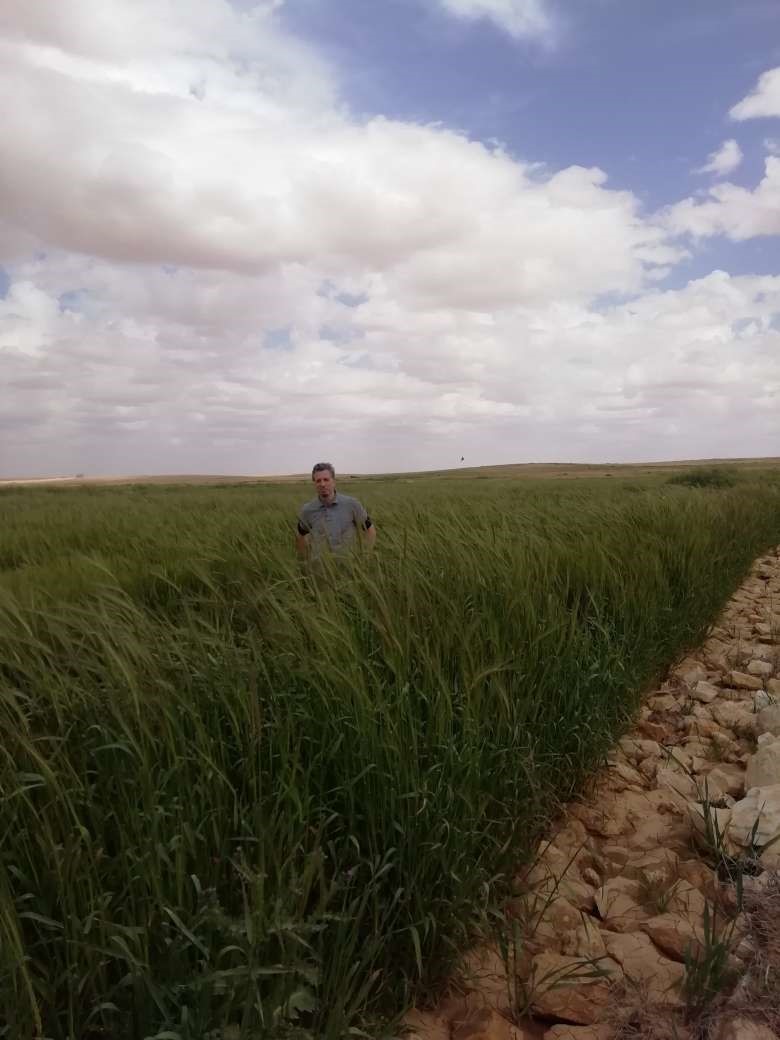
Arid drylands of Jordan receive less than 200mm average annual rainfall. The specific site is located close by Al Majeddyeh village, around 30km south-east of Amman. The average annual rainfall at the site is around 130mm. The average temperature is above 18 degrees Celsius. The human environment is characterized by agro-pastoralists. These are farmers that live in permanent houses but transport their livestock to graze. As consequence of the natural environment and mis-management (e.g. overgrazing) desertification has been an increasingly problem, not only from an environmental perspective (e.g. carbon stocking; lack of water), but also from an socio-economic perspective, because desertification leads to reduced productive lands, consequently resulting in less income for the rural population.
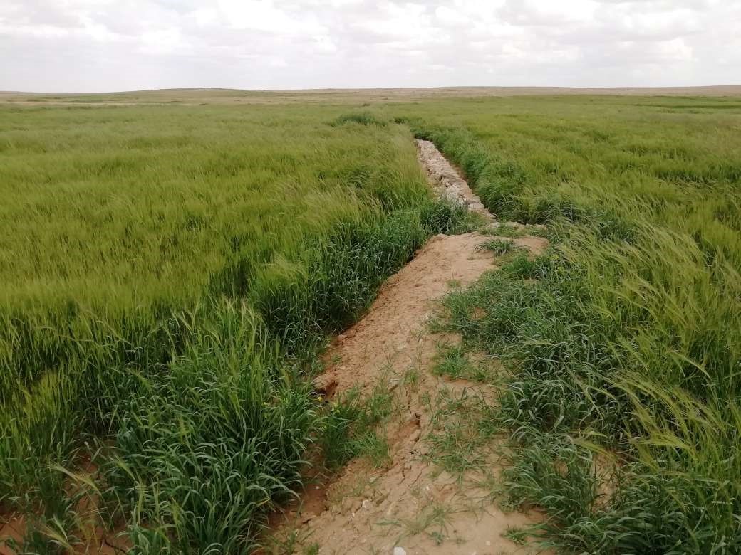
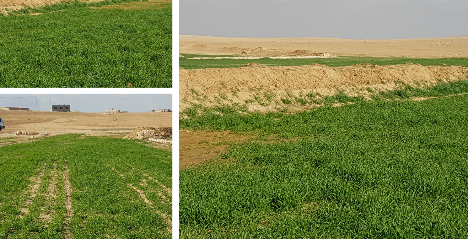
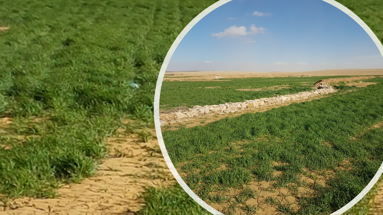
Therefore, the aim of the technology is to achieve high-yield agriculture through flood/macro-catchment water harvesting in arid environments commonly unsuitable for field crop agriculture, creating beneficial impact for local land users. The high yield barley is fed to the livestock (goats and sheeps) of the local agro-pastoralists. Applied in an integrated watershed approach, it meets agricultural demands and motivates sustainable dryland ecosystem management in the uplands. The Marab-technology has a buffering effect on extreme runoff through water retention, for further use in downstream areas, including the trapping of relative fertile sediments from upstream. As the Marab increases yields, it also improves the livelihood of the local population.
The Marab-technology is a macro-catchment water harvesting technology. The Marab is located in the natural depression of the watershed (10 square kilometres), therefore most of the water from the watershed is captured here, instead of being spilled away. Combining this natural depression with the construction of bunds and specific soil leveling, leads to decreased run-off, thus highly increased water infiltration and soil moisture. Thereby, the biomass-production increased as well.
The watershed is characterized by degraded lands upstream (720 ha), where low yield and subsidized barley cultivation is practiced, and by gullies. In a limited part (12 ha) of the upstream area, Vallerani micro-catchments are implemented as a pilot-plot. This might seem contradicting since upstream micro-catchment water harvesting decreases the water in the Marab downstream. However, the Vallerani micro-catchments also have beneficial impacts on the watershed and the Marab, such as flattening peak water flows, reducing erosion and providing fodder. The reduction in water run-off for the Marab as consequence of the Vallerani structures is not significant, due to the small size of the pilot area. But the relations between upstream and downstream should be taken into account.
Upstream watershed measures to buffer and/or avoid extreme runoff events (extreme downstream flooding) in the Marab such as micro-catchment water harvesting structures (Vallerani tractor plow system) and the out-planting of native shrub seedlings, as well as the stabilization of erosive gully systems through gully plugging and revegetation of side banks are advised to be taken before implementing the Marab technology downstream, as they safeguard and protect the Marab. But they are not further into account in this documentation.
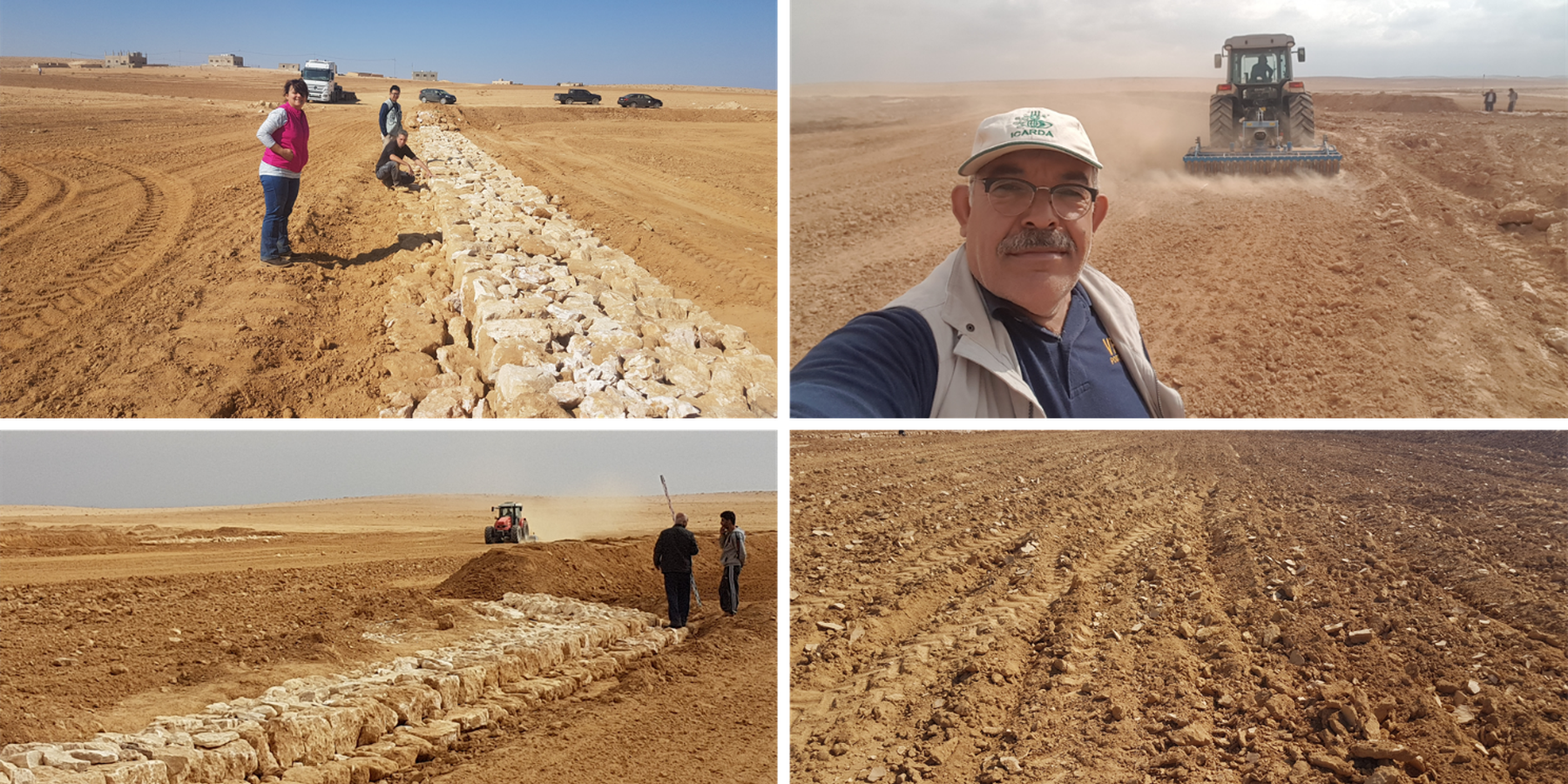
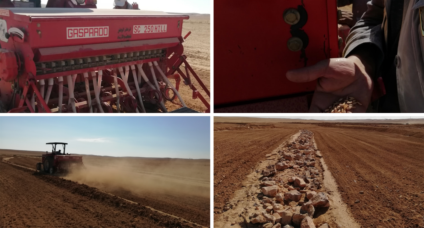
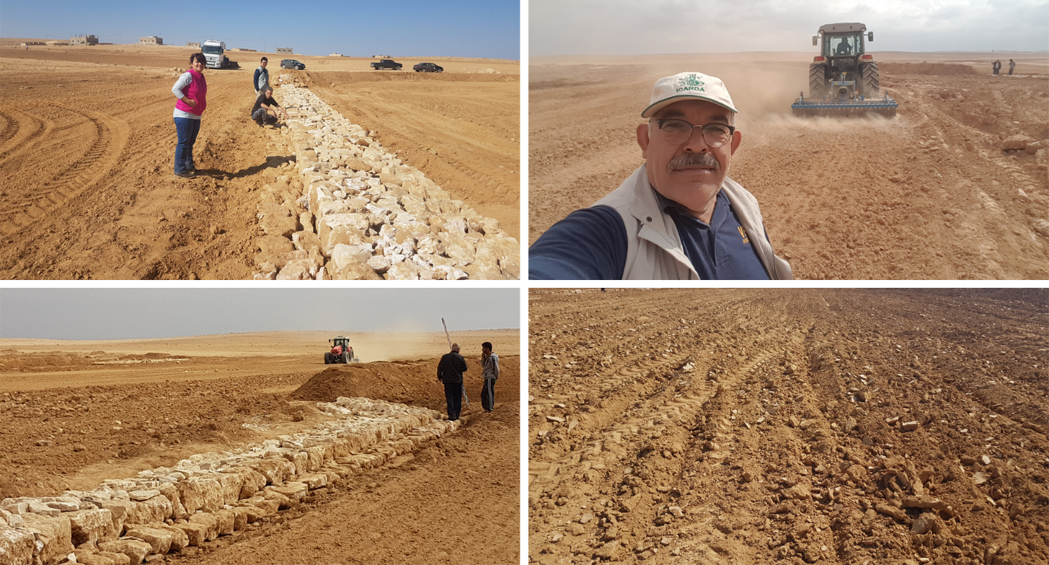
Establishment of the downstream Marab system includes:
•Local filling of downstream gull(system) with deep soil
•Leveling/grading of flood plains
•Construction of earth bunds
•Construction of the spillways (stone made)
• Seedbed preparation for planting annual crop such as barley
Marab agricultural production is high and stable. It can reach around 5-6 t ha-1 of barley, compared with the low and strongly varying yields of around 0.05-0.30 t ha-1 in traditionally, without macro water harvesting, cultivated barley. Marab barley produces grains (for fodder and reseeding purposes) and requires local inputs, such as fertilizer. The Marab mitigates downstream flooding and loss of sediments from the watershed. Local farmers applying the Marab technology are very satisfied, because of the extremely increased yield as consequence of the technology. However, as water is captured in the watershed, tensions may arise between the downstream (Marab) users and the upstream users.
2.3 Fotos da tecnologia
Galeria de Mídias

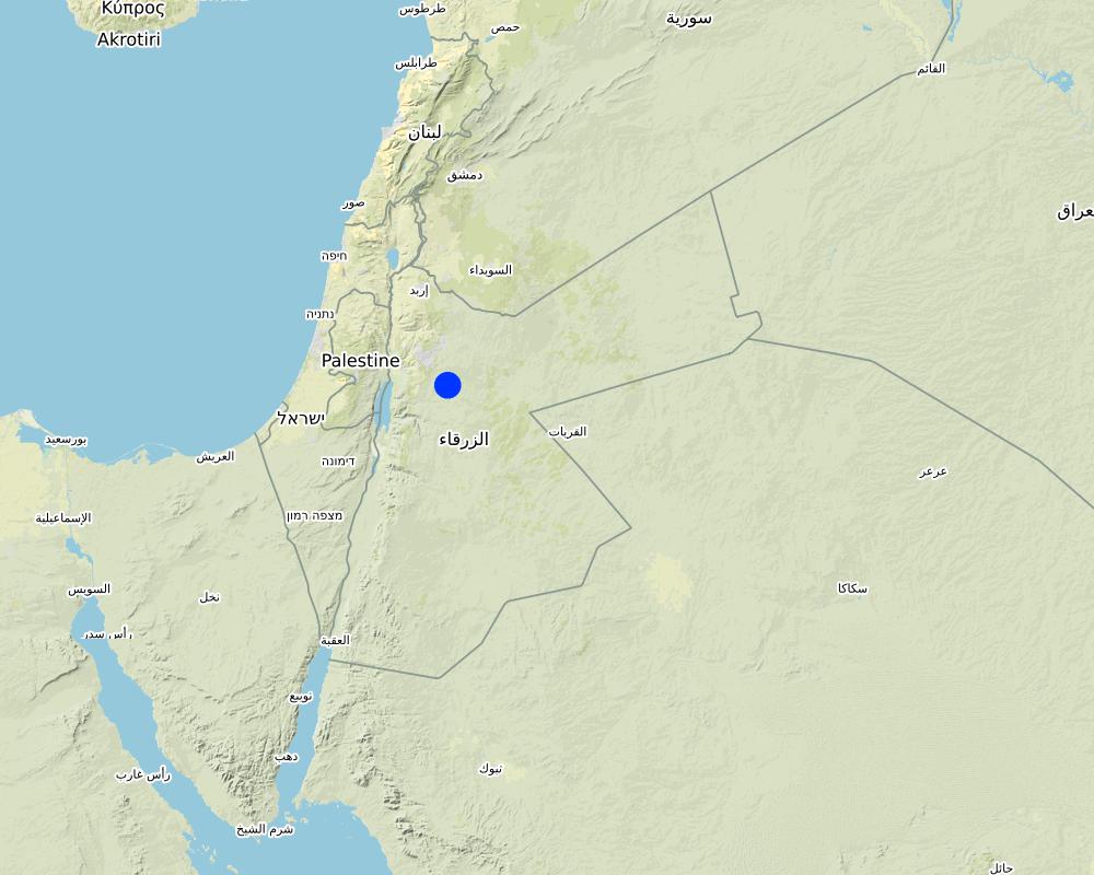
2.5 País/região/locais onde a tecnologia foi aplicada e que estão cobertos nesta avaliação
País:
Jordânia
Região/Estado/Província:
Al Jiza District
Especificação adicional de localização:
Al Majeddyeh Village
Especifique a difusão da tecnologia:
- Aplicado em pontos específicos/concentrado numa pequena área
O(s) local(is) tecnológico(s) está(ão) localizado(s) em uma área permanentemente protegida?
Não
Map
×2.6 Data da implementação
Indique o ano de implementação:
2017
2.7 Introdução da tecnologia
Especifique como a tecnologia foi introduzida:
- durante experiências/ pesquisa
- através de projetos/intervenções externas
3. Classificação da tecnologia de GST
3.1 Principal/principais finalidade(s) da tecnologia
- Melhora a produção
- Reduz, previne, recupera a degradação do solo
- Reduzir riscos de desastre
- Adaptar a mudanças climáticas/extremos e seus impactos
- Criar impacto econômico benéfico
3.2 Tipo(s) atualizado(s) de uso da terra onde a tecnologia foi aplicada
Uso do solo misturado dentro da mesma unidade de terra:
Sim
Especificar o uso misto da terra (culturas/ pastoreio/ árvores):
- Agropecuária (incl. agricultura e pecuária)

Terra de cultivo
- Cultura anual
Cultivo anual - Especificar culturas:
- cereais - cevada
Número de estações de cultivo por ano:
- 1
O cultivo entre culturas é praticado?
Não
O rodízio de culturas é praticado?
Não

Pastagem
Pastagem extensiva:
- Pastoralismo semi-nômade
Pastagem intensiva/produção de forragem:
- Semiestabulação/sem pastagem
Tipo de animal:
- caprinos
- ovelhas
É praticado o manejo integrado de culturas e pecuária?
Não
3.3 O uso do solo mudou devido à implementação da Tecnologia?
O uso do solo mudou devido à implementação da Tecnologia?
- Não (Continuar com a pergunta 3.4)
3.4 Abastecimento de água
Abastecimento de água para a terra na qual a tecnologia é aplicada:
- Precipitação natural
Comentários:
The Marab facilitates uniform distribution of excess rainwater obtained from the upland (partly Vallerani micro-catchments) and the water is conveyed through rehabilitated gullies to the Marab. (Some) Micro catchments and rehabilitated gullies are essential to avoid damaging water peaks, harming the Marab-structures. The Marab is rainfed and naturally flood irrigated.
3.5 Grupo de GST ao qual pertence a tecnologia
- Solo/cobertura vegetal melhorada
- Coleta de água
- Desvio e drenagem de água
3.6 Medidas de GST contendo a tecnologia

Medidas agronômicas
- A3: Tratamento da superfície do solo
- A4: Tratamento do subsolo

Medidas estruturais
- S2: Barragens, bancos
- S3: Valas graduadas, canais, vias navegáveis
3.7 Principais tipos de degradação da terra abordados pela tecnologia

Erosão do solo pela água
- Wt: Perda do solo superficial/erosão de superfície
- Wg: Erosão por ravinas/ravinamento
- Wo: efeitos de degradação externa

Deteriorização física do solo
- Pk: quebra e ressecamento

Degradação biológica
- Bc: redução da cobertura vegetal
- Bq: quantidade/ declínio da biomassa

Degradação da água
- Ha: aridificação
3.8 Redução, prevenção ou recuperação da degradação do solo
Especifique o objetivo da tecnologia em relação a degradação da terra:
- Reduzir a degradação do solo
Comentários:
Retaining surface runoff and locally infiltrating water through bunds increase soil moisture hence agricultural yield increases (e.g. biomass, vegetation cover) , soil crusting decreases (in some selected ponding areas it might increase) - and because of trapping top-soil sediments and residues from the uplands, soil fertility increases likewise.
4. Especificações técnicas, implementação de atividades, entradas e custos
4.1 Desenho técnico da tecnologia
Especificações técnicas (relacionada ao desenho técnico):
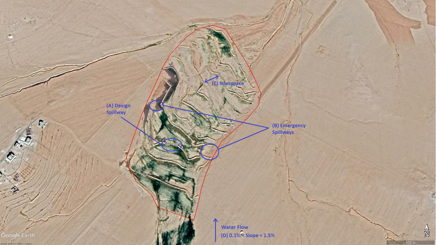
The overall Marab (reshaped flood plain) area is 10 hectares. The natural flood plain was leveled up to the sides; the natural slope in flow direction ranges between 0.1 and 1.5% (D). The later stone bund construction (soil relocation) and siltation/erosion processes over time develop a slight step-terraced bund compartment system, with the single compartments having much smaller slope than the overall Marab. At the sides, the levelled area slightly increases towards the natural terrain (natural terrain at the sides is around 0.1 to 0.3m higher compared with the leveled Marab). This avoids side outflow of water during design storms (*). Bund structures, along the contour, are built with a loader up to around 0.7 to 1.0m height and around 2.0 – 3.0m bottom width. The bunds are built with compaction through the loader. Interspace between the bunds is between 10-50 meters (C), depending on the local slope in the flow direction, having around 0.1 to 0.3m soil surface elevation difference between the bunds. Stone made design-spillways (A) are being constructed around the middle of each bund, with certain position change between the bund in downstream direction. Thus, spillways do not perfectly align with respect to the bund, but create a meandering flow around the center. The stone-protected design-spillways are designed to safely route at least the expected 2-5 year return period flood event. The Marab plain is not perfectly even, especially at the sides, to avoid water flowing around the bunds during design storms. However, the Marab-technology is also designed to cope with more extreme events, a storm of 5-10 return period, without significant damages. Therefore, there are emergency-spillways (**) implemented at the sides of each bund (B). These emergency-spillways allow excess water to flow out sideways rather than flow over the bund which would damage the structures. Note:
Based on above considerations and calculations bund spillway lengths reach 50-60m in the specific watershed.
* A design storm is a rainfall event that results in a flood event as water accumulates throughout the watershed. The Marab is designed to harvest the water optimally by (design) spill ways that keep the water in the Marab. A design storm relates to a certain return period. In general a longer return period (i.e. less frequent) accounts for a more intense event hence a more severe flooding event.
** An emergency spill way is a structure that is designed to discharge excess water coming from storms more extreme than the design storm (i.e. with less frequent storms). In practice this means that the Marab is protected from excess water.
Autor:
Joren Verbist (Extracted from Google Earth Pro on Jan 7th 2019)
Data:
19/12/2020
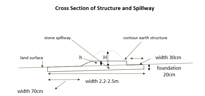
Especificações técnicas (relacionada ao desenho técnico):
The cross-section shows the dimensions. Downstream of a bund the width is 70 centimeter. The foundation is 20 centimeter high. The upstream width is 30 centimeter. The total width of the bund varies between 2.2 meter and 2.5 meter.
Autor:
Stefan Strohmeier
Data:
01/07/2020
4.2 Informação geral em relação ao cálculo de entradas e custos
Especifique como custos e entradas foram calculados:
- por área de tecnologia
Indique o tamanho e a unidade de área:
10 ha
Especifique a moeda utilizada para os cálculos de custo:
- USD
Indique a média salarial da mão-de-obra contratada por dia:
35
4.3 Atividades de implantação
| Atividade | Periodicidade (estação do ano) | |
|---|---|---|
| 1. | Implement upstream watershed rehabilitation measure (e.g. Upstream Vallerani micro water harvesting) | Prior of Marab-Technology construction |
| 2. | Implement gully rehabilitation measure (e.g. Midstream gully rehabilitation) | Prior of Marab-Technology construction |
| 3. | Marab site selection (flood plain): topographic assessment (slope, soil depth, etc.) and consideration of watershed hydrology (e.g. for bund and spillway design) | Before the rainy season |
| 4. | Grading/levelling of natural flood plain incl. gully fill (with soil material) | season (Aug. – Nov.) |
| 5. | Implement bund structures (based on step 4) | season (Aug. – Nov.) |
| 6. | Construct stone made design and emergence spillways (based on step 5) | season (Aug. – Nov.) |
| 7. | Preparation of compartmentalized agricultural fields (bund interspaces) for field crop agriculture | season (Aug. – Nov.) |
Comentários:
The upstream measures as the Vallerani System and gully rehabilitation are strongly recommended but are not taken into account as costs in this documentation. Because this documentation focuses specifically on the Marab-technology.
4.4 Custos e entradas necessárias para a implantação
| Especifique a entrada | Unidade | Quantidade | Custos por unidade | Custos totais por entrada | % dos custos arcados pelos usuários da terra | |
|---|---|---|---|---|---|---|
| Mão-de-obra | Local Workers | person-days | 50,0 | 35,0 | 1750,0 | |
| Mão-de-obra | Land Survey | person-days | 6,0 | 35,0 | 210,0 | |
| Mão-de-obra | Engineer (+assistance) | person-days | 15,0 | 50,0 | 750,0 | |
| Mão-de-obra | Drivers of heavy machinery | person-days | 12,0 | 35,0 | 420,0 | |
| Equipamento | Grader | machine-days | 3,0 | 250,0 | 750,0 | |
| Equipamento | Loader | machine-days | 10,0 | 250,0 | 2500,0 | |
| Equipamento | Deep Plow | machine-days | 3,0 | 200,0 | 600,0 | |
| Equipamento | Tractor (to pull the shallow and deep plow) | machine-days | 5,0 | 200,0 | 1000,0 | |
| Equipamento | Shallow Plow | machine-days | 2,0 | 200,0 | 400,0 | |
| Equipamento | Water Tank Truck | Tank | 1,0 | 50,0 | 50,0 | |
| Equipamento | Small Equipment (Shovel, pickaxe, buckets) | Equipment | 1,0 | 200,0 | 200,0 | |
| Material de construção | Stones | Kubic Metre | 200,0 | 10,0 | 2000,0 | |
| Outros | Transportation of heavy machinery | 1,0 | 2000,0 | 2000,0 | ||
| Outros | Security | 1,0 | 300,0 | 300,0 | ||
| Custos totais para a implantação da tecnologia | 12930,0 | |||||
| Custos totais para o estabelecimento da Tecnologia em USD | 12930,0 | |||||
Se o usuário da terra arca com menos que 100% dos custos, indique quem cobre os custos remanescentes:
ICARDA and National Agricultural Research Centre (NARC)
Comentários:
These costs are for establishment (so one-time) and are for the total Marab-technology i.e. 10 ha.
4.5 Atividades recorrentes/manutenção
| Atividade | Periodicidade/frequência | |
|---|---|---|
| 1. | Maintaining the structures based on observations and possible damages after the rainy season, so no clear maintenance plans | Before the rainy season (Oct. – Nov.)/upon observation |
Comentários:
Excludes annual farming costs (e.g. seedbed preparation)
4.6 Custos e entradas necessárias pata a manutenção/atividades recorrentes (por ano)
| Especifique a entrada | Unidade | Quantidade | Custos por unidade | Custos totais por entrada | % dos custos arcados pelos usuários da terra | |
|---|---|---|---|---|---|---|
| Mão-de-obra | Engineer | person days per year | 2,0 | 50,0 | 100,0 | 100,0 |
| Mão-de-obra | Worker | person days per year | 6,0 | 35,0 | 210,0 | 100,0 |
| Equipamento | Loader | machine days per year | 1,0 | 250,0 | 250,0 | 100,0 |
| Material de construção | Stones | Kubic Metre | 10,0 | 10,0 | 100,0 | 100,0 |
| Custos totais para a manutenção da tecnologia | 660,0 | |||||
| Custos totais de manutenção da Tecnologia em USD | 660,0 | |||||
Comentários:
The costs of practicing agriculture (e.g. cost of seeds and fertilizer) are not taken into account, since these costs were also made before the implementation of this technology.
4.7 Fatores mais importantes que afetam os custos
Descreva os fatores mais determinantes que afetam os custos:
The special and heavy machinery affect the cost significantly, since these were not available in the area. The implementation of the technology is labour intensive, therefore labour costs are significant as well. However, these costs are initially, so these specific costs are almost zero after establishment. In addition, all the maintenance is payed for by the land users. So, only the establishment was payed for by external parties.
5. Ambiente natural e humano
5.1 Clima
Precipitação pluviométrica anual
- <250 mm
- 251-500 mm
- 501-750 mm
- 751-1.000 mm
- 1.001-1.500 mm
- 1.501-2.000 mm
- 2.001-3.000 mm
- 3.001-4.000 mm
- > 4.000 mm
Especifique a média pluviométrica anual em mm (se conhecida):
130,00
Especificações/comentários sobre a pluviosidade:
In the specific site/dry areas of Jordan rainy season usually ranges from November until April
Queen Alia International Airport long-time avergae annual rainfall is around 150 mm (around 10km west of the site)
At the site a rainfall tipping bucket has been installed in 2016.
Indique o nome da estação meteorológica de referência considerada:
Queen Alia International Airport
Zona agroclimática
- Árido
The maximum temperature usually occurres in August.
The average daily maximum temperature is 25.01 °C.
The average daily minimum temperature is 8.5 °C
5.2 Topografia
Declividade média:
- Plano (0-2%)
- Suave ondulado (3-5%)
- Ondulado (6-10%)
- Moderadamente ondulado (11-15%)
- Forte ondulado (16-30%)
- Montanhoso (31-60%)
- Escarpado (>60%)
Formas de relevo:
- Planalto/planície
- Cumes
- Encosta de serra
- Encosta de morro
- Sopés
- Fundos de vale
Zona de altitude:
- 0-100 m s.n.m.
- 101-500 m s.n.m.
- 501-1.000 m s.n.m.
- 1.001-1.500 m s.n.m.
- 1.501-2.000 m s.n.m.
- 2.001-2.500 m s.n.m.
- 2.501-3.000 m s.n.m.
- 3.001-4.000 m s.n.m.
- > 4.000 m s.n.m.
Indique se a tecnologia é aplicada especificamente em:
- Posições convexas
Comentários e outras especificações sobre a topografia:
The Marab itself is rather concave (depression shape) / natural depression. However, the bund structures are convex, spreading water over the field.
5.3 Solos
Profundidade do solo em média:
- Muito raso (0-20 cm)
- Raso (21-50 cm)
- Moderadamente profundo (51-80 cm)
- Profundo (81-120 cm)
- Muito profundo (>120 cm)
Textura do solo (solo superficial):
- Médio (limoso, siltoso)
- Fino/pesado (argila)
Textura do solo (>20 cm abaixo da superfície):
- Médio (limoso, siltoso)
Matéria orgânica do solo superficial:
- Baixo (<1%)
5.4 Disponibilidade e qualidade de água
Lençol freático:
> 50 m
Disponibilidade de água de superfície:
Precário/nenhum
Qualidade da água (não tratada):
Inutilizável
A qualidade da água refere-se a:
água de superfície
A salinidade da água é um problema?
Não
Ocorre inundação da área?
Sim
Regularidade:
Frequentemente
5.5 Biodiversidade
Diversidade de espécies:
- Baixo
Diversidade de habitat:
- Baixo
5.6 Características dos usuários da terra que utilizam a tecnologia
Sedentário ou nômade:
- Semi-nômade
Orientação de mercado do sistema de produção:
- misto (subsistência/comercial)
Rendimento não agrícola:
- Menos de 10% de toda renda
Nível relativo de riqueza:
- Pobre
- Média
Indivíduos ou grupos:
- Indivíduo/unidade familiar
Nível de mecanização:
- Mecanizado/motorizado
Gênero:
- Homens
Idade dos usuários da terra:
- Jovens
- meia-idade
Indique outras características relevantes dos usuários da terra:
The actual land users are often poor Jordanians or Syrian refugees. However, the owners of the livestock are relatively rich. The landowners are responsible for the maintenance of the intervention.
5.7 Área média de terrenos utilizados pelos usuários de terrenos que aplicam a Tecnologia
- < 0,5 ha
- 0,5-1 ha
- 1-2 ha
- 2-5 ha
- 5-15 ha
- 15-50 ha
- 50-100 ha
- 100-500 ha
- 500-1.000 ha
- 1.000-10.000 ha
- > 10.000 ha
É considerado pequena, média ou grande escala (referente ao contexto local)?
- Média escala
Comentários:
10ha
5.8 Propriedade de terra, direitos de uso da terra e de uso da água
Propriedade da terra:
- Indivíduo, intitulado
Direitos do uso da terra:
- Arrendado
- Indivíduo
- NA
Os direitos de uso da terra são baseados em um sistema jurídico tradicional?
Sim
5.9 Acesso a serviços e infraestrutura
Saúde:
- Pobre
- Moderado
- Bom
Educação:
- Pobre
- Moderado
- Bom
Assistência técnica:
- Pobre
- Moderado
- Bom
Emprego (p. ex. não agrícola):
- Pobre
- Moderado
- Bom
Mercados:
- Pobre
- Moderado
- Bom
Energia:
- Pobre
- Moderado
- Bom
Vias e transporte:
- Pobre
- Moderado
- Bom
Água potável e saneamento:
- Pobre
- Moderado
- Bom
Serviços financeiros:
- Pobre
- Moderado
- Bom
6. Impactos e declarações finais
6.1 Impactos no local mostrados pela tecnologia
Impactos socioeconômicos
Produção
Produção agrícola
Comentários/especificar:
The crops produced are used as fodder
Produção de forragens
Quantidade anterior à GST:
0.05ton/ha
Quantidade posterior à GST:
5ton/ha
Comentários/especificar:
The production of the fodder is increased as the barley yield is mostly used to feed animals and also the stubble is grazed.
Qualidade da forragem
Comentários/especificar:
The barley is fed to the livestock
Área de produção
Comentários/especificar:
Due to the bunds (but very limited and inevitable)
Gestão de terra
Renda e custos
Despesas com insumos agrícolas
Comentários/especificar:
Expenses are slightly increased due to possible maintenance of the Marab. However, the increased yield justifies this.
Rendimento agrícola
Carga de trabalho
Comentários/especificar:
Due to possible maintenance
Impactos socioculturais
Segurança alimentar/auto-suficiência
Conhecimento de GST/ degradação da terra
Comentários/especificar:
During the construction, local community were hired as workers, this has significantly boosted their knowlegde about SLM.
Impactos ecológicos
Ciclo hídrico/escoamento
Colheita/recolhimento de água
Escoamento superficial
Drenagem de excesso de água
Lençol freático/aquífero
Solo
Umidade do solo
Cobertura do solo
Perda de solo
Acumulação de solo
Ressecamento/ selagem do solo
Matéria orgânica do solo/carbono abaixo do solo
Biodiversidade: vegetação, animais
Cobertura vegetal
Biomassa/carbono acima do solo
Clima e redução de riscos de desastre
Impactos da inundação
Impactos da seca
6.2 Impactos externos mostrados pela tecnologia
Cheias de jusante
Comentários/especificar:
Reduced downstream flooding is desired
Sedimentação a jusante
Comentários/especificar:
Reduced downstream siltation is desired
6.3 Exposição e sensibilidade da tecnologia às mudanças climáticas graduais e extremos/desastres relacionados ao clima (conforme o ponto de vista dos usuários da terra)
Mudança climática gradual
Mudança climática gradual
| Estação do ano | aumento ou diminuição | Como a tecnologia lida com isso? | |
|---|---|---|---|
| Precipitação pluviométrica anual | redução/diminuição | bem |
Extremos (desastres) relacionados ao clima
Desastres meteorológicos
| Como a tecnologia lida com isso? | |
|---|---|
| Temporal local | muito bem |
Desastres hidrológicos
| Como a tecnologia lida com isso? | |
|---|---|
| Inundação súbita | muito bem |
6.4 Análise do custo-benefício
Como os benefícios se comparam aos custos de implantação (do ponto de vista dos usuários da terra)?
Retornos a curto prazo:
levemente negativo
Retornos a longo prazo:
positivo
Como os benefícios se comparam aos custos recorrentes/de manutenção(do ponto de vista dos usuários da terra)?
Retornos a curto prazo:
positivo
Retornos a longo prazo:
muito positivo
Comentários:
The initial investment is quite large. Therefore, the short term returns is classified as slightly negative. After some seasons with good (stable) crop yield the return of investment is positive. Long term benefits are classified positively.
6.5 Adoção da tecnologia
- 1-10%
Se disponível, determine a quantidade (número de unidades familiares e/ou área abordada):
These are some farmers that live near the Marab. They try to copy the Marab in their fields.
De todos aqueles que adotaram a Tecnologia, quantos o fizeram espontaneamente, ou seja, sem receber nenhum incentivo/ pagamento material?
- 91-100%
Comentários:
The local farmers like the technology and acknowledge its positive impacts. They would like to have a Marab themselves (even if their locally owned lands are not suitable in many cases). Local agro-pastoralists copy and apply parts of the technology (especially the bund
system). However, it strongly recommended that implementing a Marab-technology is done as a community-based project/intervention; the Marab technology should be part of an integrated watershed management plan, located at the most suitable location for the entire community.
6.6 Adaptação
A tecnologia foi recentemente modificada para adaptar-se as condições variáveis?
Sim
Caso afirmativo, indique as condições variáveis as quais ela foi adaptada:
- Mudança climática/extremo
Especifique a adaptação da tecnologia (desenho, material/espécie, etc):
The spillway design can be adapted to variable surface runoff occurrence (affected by climate change).
6.7 Pontos fortes/vantagens/oportunidades da tecnologia
| Pontos fortes/vantagens/oportunidades na visão do usuário da terra |
|---|
| The farmers highly appreciate the improved economic situation as consequence of the increased yield. |
| A strength of the Marab technology is that water is harvested and minimally spilled away, preventing top-soil erosion and accumulating soil organic matter consequently preserving soil fertility. |
| The crop produces grains: can be (partially) used for re-seeding in the coming seasons; economic gain + increase resilience. |
| Pontos fortes/vantagens/oportunidades na visão do compilador ou de outra pessoa capacitada |
|---|
| Economic improvement through targeted agricultural interventions in the most suitable location(s) of a watershed. This aims at decreasing the pressure on the fragile dry land ecosystem. The locally increased yield raises awareness on non-sufficient field crop agriculture in uplands (commonly achieved) and might increase the willingness for more nature-based sustainable land management measures in the less fertile and runoff generating (more vulnerable uplands) parts of the watershed. Therefore, the Marab technology could be a starting point for a watershed rehabilitation initiative. |
| The Marab technology creates an opportunity for multiple crop introduction (due to natural flood irrigation) – aside from barley monoculture (agro-diversity). |
| Increased water infiltration conserves water and might lead to deep percolation (groundwater recharge). |
6.8 Pontos fracos, desvantagens/riscos da tecnologia e formas de superá-los
| Pontos fracos/desvantagens/riscos na visão do usuário da terra | Como eles podem ser superados? |
|---|---|
| The Marab depends on upstream water users; can lead to increased tensions | Agreement among the community - conducting contacts/contracts among upstream and downstream farmers. Joint watershed management and benefit share could be mediate these tension. And might even lead to watershed rehabilitation. |
| High initial investment and partially high maintenance costs (including machinery) | Once the implementation is linked with larger environmental benefits – communities might receive funds from the government or international donors. |
| Loss of cultivation area where the bunds are placed | Unavoidable. However, the gain of interspaces exceeds these losses several times. |
| Pontos fracos/vantagens/riscos na visão do compilador ou de outra pessoa capacitada | Como eles podem ser superados? |
|---|---|
| Tensions among multiple actors in the watershed (selection of Marab area) | Develop institutions that could avoid these tensions by establishing agreements, contracts, rules, or regulations. |
| Heavy machinery in a vulnerable ecosystems – can induce other requests/use by locals (improper use) | Targeted policies in place & enforcements |
| Increasing wealth inequality between farmers and/or communities. | Creation of institutions, which assure fair distribution. This would benefit the whole watershed. |
7. Referências e links
7.1 Métodos/fontes de informação
- visitas de campo, pesquisas de campo
- entrevistas com usuários de terras
- entrevistas com especialistas em GST
- compilação de relatórios e outra documentação existente
Quando os dados foram compilados (no campo)?
15/04/2020
7.2 Referências às publicações disponíveis
Título, autor, ano, ISBN:
Strohmeier, S. (2017). Dimensioning of Marab in Majidyya.
Título, autor, ano, ISBN:
Strohmeier, S. (2017). Watershed Restoration in Baia Areas of Jordan Technology Packages for Controlling and Monitoring Gully Erosion.
Disponível de onde? Custos?
https://mel.cgiar.org/projects/jordan-watershed-restoration-project
Título, autor, ano, ISBN:
Mira Haddad, Stefan Strohmeier. (12/12/2017). Treated upland areas map. Jordan: International Center for Agricultural Research in the Dry Areas (ICARDA).
Disponível de onde? Custos?
https://hdl.handle.net/20.500.11766/9108
Título, autor, ano, ISBN:
Stefan Strohmeier, Mira Haddad, Ismail Shukri. (8/11/2018). Marab - water harvesting based agriculture.
Disponível de onde? Custos?
https://hdl.handle.net/20.500.11766/9069
Título, autor, ano, ISBN:
Boubaker Dhehibi, Mira Haddad, Stefan Strohmeier, Masnat El-Hiary. (24/7/2020). Enhancing a Traditional Water Harvesting Technique in Jordan’s Agro-pastoral Farming System. Lebanon: International Center for Agricultural Research in the Dry Areas (ICARDA).
Disponível de onde? Custos?
https://hdl.handle.net/20.500.11766/11506
7.3 Links para informações on-line relevantes
Título/ descrição:
WATER HARVESTING FOR RESTORING RANGELANDS IN JORDAN
URL:
https://www.icarda.org/media/drywire/water-harvesting-restoring-rangelands-jordan
Links e módulos
Expandir tudo Recolher tudoLinks
Não há links
Módulos
Não há módulos