Contour trenches and contour strips [Uzbequistão]
- Criação:
- Atualização:
- Compilador/a: Joren Verbist
- Editor: Hayot Ibrakhimov
- Revisores: William Critchley, Rima Mekdaschi Studer
technologies_7557 - Uzbequistão
Veja as seções
Expandir tudo Recolher tudo1. Informação geral
1.2 Detalhes do contato das pessoas capacitadas e instituições envolvidas na avaliação e documentação da tecnologia
Senior Scientist Sustainable Land Management:
Akramkhanov Akmal
International Center of Agriculture Research in the Dry Areas (ICARDA)
Uzbequistão
Crop Specialist:
Fayzullayev Abdulla
International Center of Agriculture Research in the Dry Areas (ICARDA)
Uzbequistão
Water Harvesting Expert:
Muddaber Mohammad Ali
International Center of Agriculture Research in the Dry Areas (ICARDA)
Jordânia
Water Harvesting Expert:
Jafar Alwidyan
International Center of Agriculture Research in the Dry Areas (ICARDA)
Jordânia
Project Manager:
Nurbekov Aziz
Food and Agriculture Organization (FAO) of the United Nations
Uzbequistão
Nome do projeto que facilitou a documentação/avaliação da Tecnologia (se relevante)
ICARDA Institutional Knowledge Management InitiativeNome do projeto que facilitou a documentação/avaliação da Tecnologia (se relevante)
Food Systems, Land Use, and Restoration Impact Program in Uzbekistan (GCP/UZB/010/GFF) (FOLUR)Nome da(s) instituição(ões) que facilitou(ram) a documentação/ avaliação da Tecnologia (se relevante)
International Center for Agricultural Research in the Dry Areas (ICARDA) - Líbano1.3 Condições em relação ao uso da informação documentada através de WOCAT
O/a compilador/a e a(s) pessoa(s) capacitada(s) aceitam as condições relativas ao uso de dados documentados através da WOCAT:
Sim
1.4 Declaração de sustentabilidade da tecnologia descrita
A tecnologia descrita aqui é problemática em relação a degradação da terra de forma que não pode ser declarada uma tecnologia de gestão sustentável de terra?
Não
2. Descrição da tecnologia de GST
2.1 Descrição curta da tecnologia
Definição da tecnologia:
Contour trenches for the cultivation of almond trees, and contour strips for cereals are types of rainwater harvesting structures. They are designed to capture runoff, reduce erosion, and enhance soil moisture—thereby improving land productivity and supporting climate-resilient agriculture in lowland dry areas.
2.2 Descrição detalhada da tecnologia
Descrição:
Qashqadaryo Province in southern Uzbekistan experiences a hot, dry summer and a mild winter. Combined with unsustainable land management practices, climatic stresses have exacerbated land degradation and made local livelihoods increasingly vulnerable.
As part of the Food Systems, Land Use and Restoration (FOLUR) project, the International Center for Agricultural Research in the Dry Areas (ICARDA) designed and tested rainwater harvesting (RWH) structures to combat land degradation and enhance rural livelihoods. These RWH structures support vegetation growth, reduce surface runoff, prevent erosion, and restore soil health—thereby reversing degradation and improving agricultural productivity.
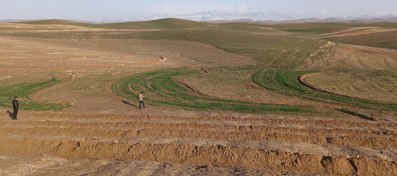
Based on slope gradients and hydrological characteristics, two RWH techniques were selected: modified contour trenches for the slightly sloping upper areas, and modified contour strips for the flatter zones.
In the upper portion of the site, which spans 1.54 hectares, modified contour trenches were implemented for perennial tree crops. Design calculations suggested a spacing of 8 metres between trenches, and 7 metres between almond trees along each trench.
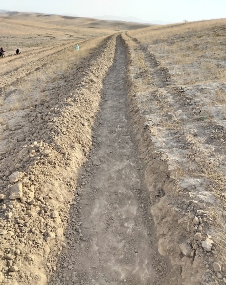
Implementation began with the marking of contour lines using a laser level: two labourers worked for two days. Then a tractor fitted with a three-mouldboard plough dug the trenches. While the tractor generally performed well, work had to be completed manually at sharp bends and gully crossings. Eight labourers then spent two days shaping and stabilizing the trenches. In total, approximately 1,300 metres of trench lines were created.
Costs were relatively modest. The tractor, hired from a farmer, cost $150 per day. Manual labour amounted to 24 person-days at $10 per day. 100 almond trees were planted, and 85 tamarix trees were added as a protective windbreak.
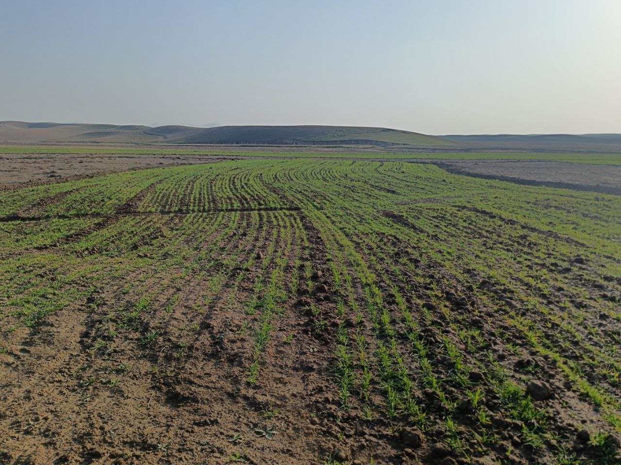
In the lower, flatter part of the site—about 1.68 hectares—standard contour strips were unsuitable due to the very low slope, which would not generate enough runoff. Instead, a modified version was implemented. Low ridges along contour at a vertical interval of 30 cm, allowed rainwater to pool and infiltrate. The same tractor was used with a single mouldboard plough to form nine contour ridges, shaped by two passes.
Afterwards, ten local women labourers finalized the ridges manually. The total length of the contour strips reached 500 metres, and the ratio of catchment to cultivated area varied from 5:1 in the upper sections to 1:1 in the lower zones, based on expected runoff.
The cost of this phase included one day of tractor use and 15 person-days of labour, totalling approximately $300. This site is intended for rainfed cultivation, and will follow a crop rotation system including barley, legumes and fallow periods. Over time, farmers are encouraged to adopt no-till practices to improve soil health.
Following implementation, light rainfall provided a test of the structures. Both the contour trenches and strips performed as intended, with no damage observed.
The interventions demonstrate how a tailored combination of RWH structures and cropping systems can rehabilitate degraded land. Local involvement helped to build community ownership. The result is a more productive and climate-resilient landscape that offers long-term benefits for soil conservation and rural livelihoods.
Acknowledgement: This SLM was introduced by ICARDA in the framework of Food Systems, Land Use and Restoration Impact Program (FOLUR) in Uzbekistan (GCP/UZB/010/GFF), implemented by FAO with funding from the Global Environment Facility (GEF)
2.3 Fotos da tecnologia
Galeria de Mídias
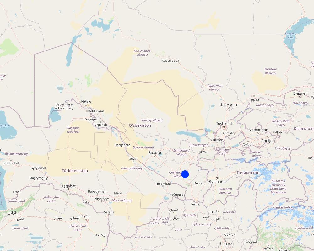
2.5 País/região/locais onde a tecnologia foi aplicada e que estão cobertos nesta avaliação
País:
Uzbequistão
Região/Estado/Província:
Qashqadaryo Province in southern Uzbekistan
Especificação adicional de localização:
8°43'14.26"N, 66°41'51.87"E
Especifique a difusão da tecnologia:
- Uniformemente difundida numa área
Se a área precisa não for conhecida, indicar a área aproximada coberta:
- < 0,1 km2 (10 ha)
O(s) local(is) tecnológico(s) está(ão) localizado(s) em uma área permanentemente protegida?
Não
Map
×2.6 Data da implementação
Indique o ano de implementação:
2024
2.7 Introdução da tecnologia
Especifique como a tecnologia foi introduzida:
- através de projetos/intervenções externas
3. Classificação da tecnologia de GST
3.1 Principal/principais finalidade(s) da tecnologia
- Melhora a produção
- Reduz, previne, recupera a degradação do solo
- Adaptar a mudanças climáticas/extremos e seus impactos
- Criar impacto econômico benéfico
- Cria impacto social benéfico
3.2 Tipo(s) atualizado(s) de uso da terra onde a tecnologia foi aplicada
Uso do solo misturado dentro da mesma unidade de terra:
Não

Terra de cultivo
- Cultura anual
- Cultura perene (não lenhosa)
Cultivo anual - Especificar culturas:
- cereais - cevada
- Nuts/ fruits including almonds
Número de estações de cultivo por ano:
- 1
O cultivo entre culturas é praticado?
Não
O rodízio de culturas é praticado?
Sim
Caso afirmativo, especifique:
Barley, legumes etc
Comentários:
Note fruits/ nuts on one part of the land and cereals/ legumes/ fodder on another section (see 2.2)
3.3 O uso do solo mudou devido à implementação da Tecnologia?
O uso do solo mudou devido à implementação da Tecnologia?
- Sim (Por favor, preencha as perguntas abaixo com relação ao uso do solo antes da implementação da Tecnologia)
Uso do solo misturado dentro da mesma unidade de terra:
Não

Pastagem
Pastagem extensiva:
- Pastoralismo semi-nômade
- Mixed
3.4 Abastecimento de água
Abastecimento de água para a terra na qual a tecnologia é aplicada:
- Precipitação natural
3.5 Grupo de GST ao qual pertence a tecnologia
- Solo/cobertura vegetal melhorada
- Medidas de curva de nível
- Coleta de água
3.6 Medidas de GST contendo a tecnologia

Medidas agronômicas
- A1: cobertura vegetal/do solo
- A3: Tratamento da superfície do solo
- A4: Tratamento do subsolo

Medidas vegetativas
- V1: cobertura de árvores/arbustos

Medidas estruturais
- S1: Terraços
- S2: Barragens, bancos
- S3: Valas graduadas, canais, vias navegáveis
- S7: coleta de água/ equipamento de abastecimento/irrigação

Medidas de gestão
- M1: Mudança no tipo de uso da terra
3.7 Principais tipos de degradação da terra abordados pela tecnologia

Erosão do solo pela água
- Wt: Perda do solo superficial/erosão de superfície
- Wg: Erosão por ravinas/ravinamento
- Wo: efeitos de degradação externa

Erosão do solo pelo vento
- Et: Perda do solo superficial
- Ed: deflação e deposição
- Eo: efeitos de degradação externa

Deteriorização física do solo
- Pc: Compactação
- Pk: quebra e ressecamento

Degradação biológica
- Bc: redução da cobertura vegetal
- Bq: quantidade/ declínio da biomassa
- Bl: perda da vida do solo
3.8 Redução, prevenção ou recuperação da degradação do solo
Especifique o objetivo da tecnologia em relação a degradação da terra:
- Reduzir a degradação do solo
- Recuperar/reabilitar solo severamente degradado
4. Especificações técnicas, implementação de atividades, entradas e custos
4.1 Desenho técnico da tecnologia
Especificações técnicas (relacionada ao desenho técnico):
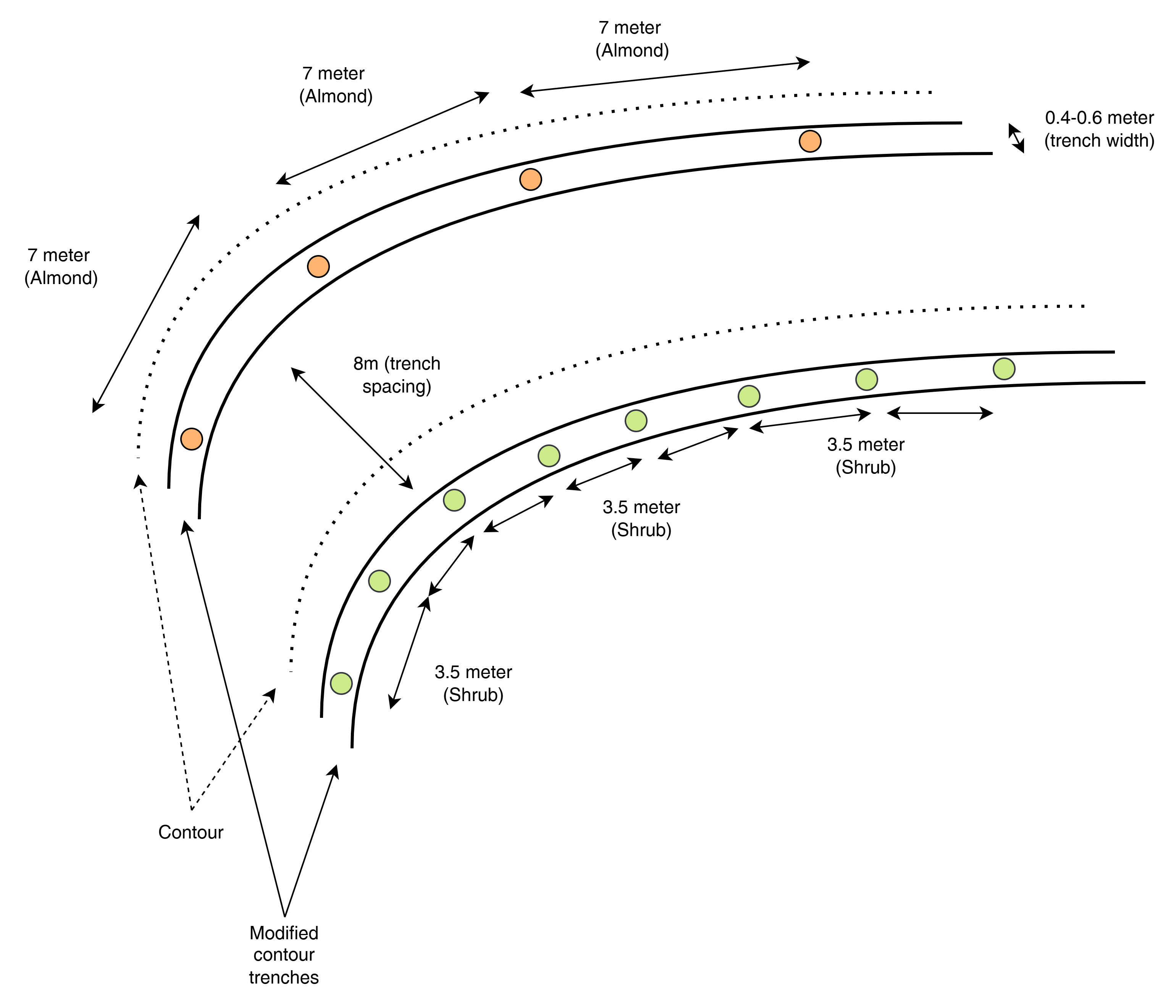
This top-view diagram shows the layout of modified contour trenches along contour lines, spaced 8 meters apart vertically. Each trench supports either:
Almond trees, spaced 7 meters apart, or
Shrubs, spaced 3.5 meters apart.
Each trench is aligned to follow the natural contour of the land to intercept runoff and enhance infiltration. Shrubs and trees are planted separately in designated trenches, not mixed.
Autor:
ICARDA
Data:
2025
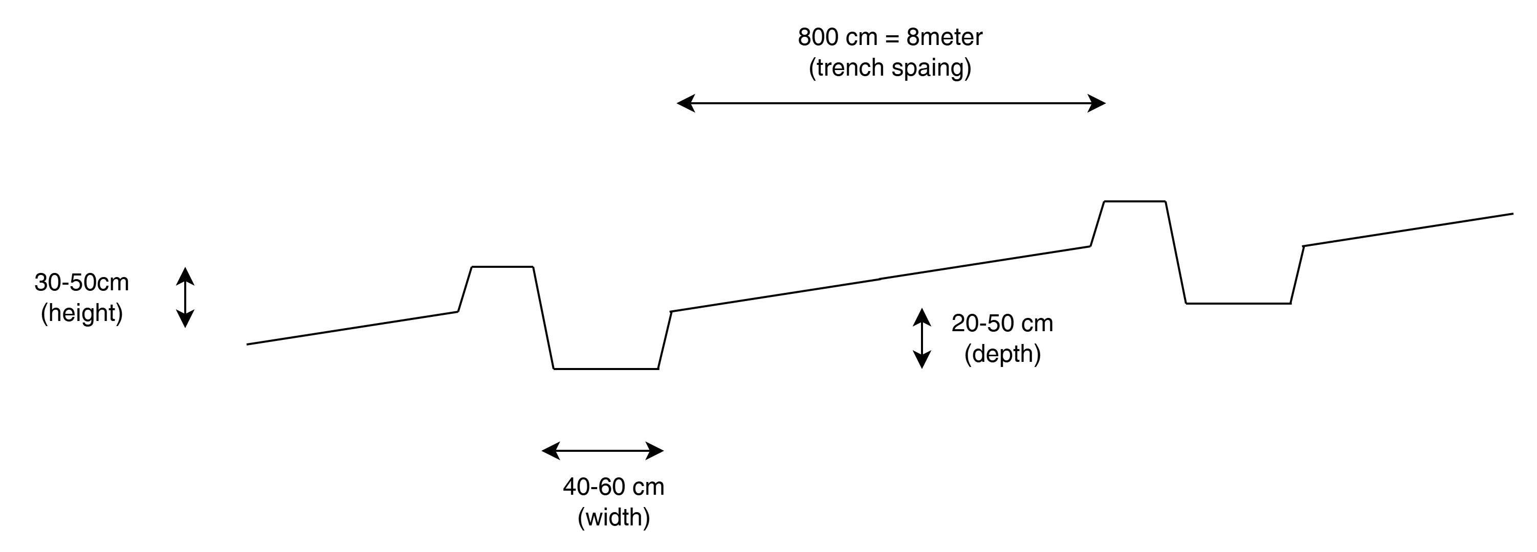
Especificações técnicas (relacionada ao desenho técnico):
This cross-sectional profile illustrates the physical dimensions of a modified contour trench:
Width: 40–60 cm
Depth: 20–50 cm
Bund height (upslope side): 30–50 cm
Trench spacing: 8 meters
These dimensions are designed to retain and slow down surface runoff on slopes of 10–20%, enhancing water infiltration for tree or shrub growth.
Autor:
ICARDA
Data:
2025
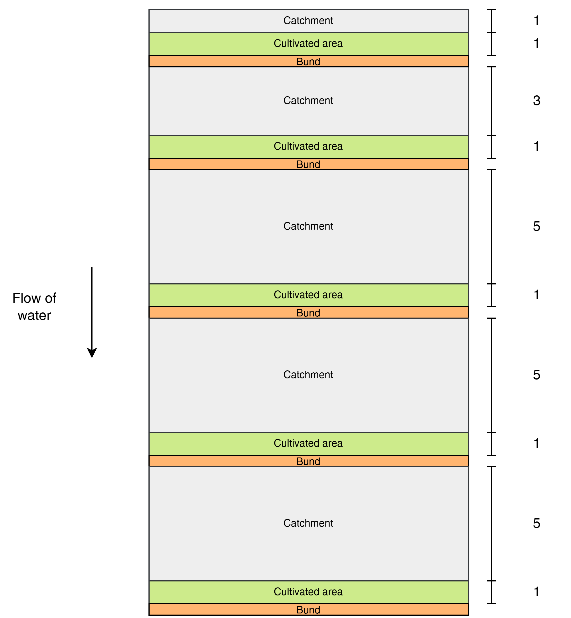
Especificações técnicas (relacionada ao desenho técnico):
This diagram shows the layout of modified contour strips designed to enhance rainwater harvesting and crop productivity on sloped land. Each unit consists of a cultivated strip supported by a bund, located just downslope of a catchment area that concentrates surface runoff toward the crops.
Water flows downslope through the system.
The catchment-to-cultivated area ratio increases downslope to account for the growing volume and force of accumulated runoff, as well as differences in slope and infiltration capacity:
1:1 in the upper strips, where the steeper slope generates stronger runoff, and only limited water is desired to avoid erosion or damage.
3:1 in the middle strips, where moderate runoff accumulates.
5:1 in the lower strips, where the gentler slope allows more infiltration and where the lower kinetic energy of the runoff poses less risk to the structures.
Autor:
ICARDA
Data:
2025
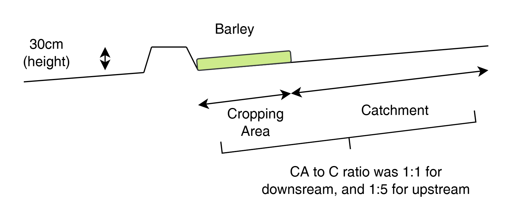
Especificações técnicas (relacionada ao desenho técnico):
This cross-sectional view illustrates a modified contour strip:
A 30 cm high earth bund holds runoff upslope.
The cropping area (e.g., barley) is placed directly upstream (behind) the bund.
A catchment area lies upslope, sloped to direct water into the cultivated zone.
The catchment-to-cultivated ratio ranges from 5:1 (upper strips) to 1:1 (lower strips) depending on expected runoff volume, ensuring efficient water use and soil conservation.
Autor:
ICARDA
Data:
2025
4.2 Informação geral em relação ao cálculo de entradas e custos
Especifique como custos e entradas foram calculados:
- por área de tecnologia
Indique o tamanho e a unidade de área:
3 ha (with half: half of each RWH technology)
Especifique a moeda utilizada para os cálculos de custo:
- USD
Indique a média salarial da mão-de-obra contratada por dia:
10
4.3 Atividades de implantação
| Atividade | Periodicidade (estação do ano) | |
|---|---|---|
| 1. | Contour marking | 22–23 September |
| 2. | Tractor ploughing | 24–25 September |
| 3. | Manual shaping/finishing | 25–26 September |
| 4. | Tree/shrub planting | 26–27 September |
4.4 Custos e entradas necessárias para a implantação
| Especifique a entrada | Unidade | Quantidade | Custos por unidade | Custos totais por entrada | % dos custos arcados pelos usuários da terra | |
|---|---|---|---|---|---|---|
| Mão-de-obra | Contour trench construction | Person-days | 24,0 | |||
| Mão-de-obra | Bunds for contour strips | Person-days | 15,0 | |||
| Mão-de-obra | Marking contours | Person-days | 4,0 | |||
| Equipamento | Ploughing (contour trenches) | Machine-days | 3,0 | |||
| Equipamento | Ploughing (contour strips) | Machine-days | 2,0 | |||
| Material vegetal | Almond seedlings | 100,0 | ||||
| Material vegetal | Shrubs | 85,0 | ||||
| Fertilizantes e biocidas | Manure | kg | 600,0 | |||
| Outros | Lumpsum contour strips | 1,0 | 1000,0 | 1000,0 | ||
| Outros | Lumpsum contour trenches | 1,0 | 1000,0 | 1000,0 | ||
| Custos totais para a implantação da tecnologia | 2000,0 | |||||
| Custos totais para o estabelecimento da Tecnologia em USD | 2000,0 | |||||
Se você não conseguir discriminar os custos na tabela acima, forneça uma estimativa dos custos totais para estabelecer a Tecnologia:
2000,0
Comentários:
Total implementation costs are around 2k USD. 50/50 between the two designs.
We have spent around 310 for tractor
300 for loader for levelling
270 labour for shaping the pits (after tractor)
400 for ploughing prior of planting the barley
340 for no till planter services for planting the barley
250 labour for applying fertilizer
100 for fertilizer (inc transport)
Estimation 20-50 for labour for plating the seedlings
4.5 Atividades recorrentes/manutenção
| Atividade | Periodicidade/frequência | |
|---|---|---|
| 1. | Inspection and incidental repairs | |
| 2. | Potentially sediment cleaning |
4.6 Custos e entradas necessárias pata a manutenção/atividades recorrentes (por ano)
Comentários:
No numbers have been recorded yet as the structures are new. An estimate of the maintenance costs would be 10-25% of the establishment costs.
5. Ambiente natural e humano
5.1 Clima
Precipitação pluviométrica anual
- <250 mm
- 251-500 mm
- 501-750 mm
- 751-1.000 mm
- 1.001-1.500 mm
- 1.501-2.000 mm
- 2.001-3.000 mm
- 3.001-4.000 mm
- > 4.000 mm
Especifique a média pluviométrica anual em mm (se conhecida):
325,00
Zona agroclimática
- Semiárido
5.2 Topografia
Declividade média:
- Plano (0-2%)
- Suave ondulado (3-5%)
- Ondulado (6-10%)
- Moderadamente ondulado (11-15%)
- Forte ondulado (16-30%)
- Montanhoso (31-60%)
- Escarpado (>60%)
Formas de relevo:
- Planalto/planície
- Cumes
- Encosta de serra
- Encosta de morro
- Sopés
- Fundos de vale
Zona de altitude:
- 0-100 m s.n.m.
- 101-500 m s.n.m.
- 501-1.000 m s.n.m.
- 1.001-1.500 m s.n.m.
- 1.501-2.000 m s.n.m.
- 2.001-2.500 m s.n.m.
- 2.501-3.000 m s.n.m.
- 3.001-4.000 m s.n.m.
- > 4.000 m s.n.m.
Indique se a tecnologia é aplicada especificamente em:
- Não relevante
Comentários e outras especificações sobre a topografia:
The strips are better suited for the flatter areas and the trenches on the higher sloping areas.
5.3 Solos
Profundidade do solo em média:
- Muito raso (0-20 cm)
- Raso (21-50 cm)
- Moderadamente profundo (51-80 cm)
- Profundo (81-120 cm)
- Muito profundo (>120 cm)
Textura do solo (solo superficial):
- Médio (limoso, siltoso)
Textura do solo (>20 cm abaixo da superfície):
- Médio (limoso, siltoso)
Matéria orgânica do solo superficial:
- Médio (1-3%)
5.4 Disponibilidade e qualidade de água
Lençol freático:
5-50 m
Disponibilidade de água de superfície:
Precário/nenhum
Qualidade da água (não tratada):
apenas para uso agrícola (irrigação)
A qualidade da água refere-se a:
tanto de águas subterrâneas quanto de superfície
A salinidade da água é um problema?
Não
Ocorre inundação da área?
Sim
Regularidade:
Esporadicamente
5.5 Biodiversidade
Diversidade de espécies:
- Baixo
Diversidade de habitat:
- Baixo
5.6 Características dos usuários da terra que utilizam a tecnologia
Sedentário ou nômade:
- Sedentário
Orientação de mercado do sistema de produção:
- misto (subsistência/comercial)
Rendimento não agrícola:
- 10-50% de toda renda
Nível relativo de riqueza:
- Muito pobre
- Pobre
Indivíduos ou grupos:
- Indivíduo/unidade familiar
- Empregado (empresa, governo)
Nível de mecanização:
- Trabalho manual
- Mecanizado/motorizado
Gênero:
- Homens
Idade dos usuários da terra:
- Crianças
- meia-idade
5.7 Área média de terrenos utilizados pelos usuários de terrenos que aplicam a Tecnologia
- < 0,5 ha
- 0,5-1 ha
- 1-2 ha
- 2-5 ha
- 5-15 ha
- 15-50 ha
- 50-100 ha
- 100-500 ha
- 500-1.000 ha
- 1.000-10.000 ha
- > 10.000 ha
É considerado pequena, média ou grande escala (referente ao contexto local)?
- Pequena escala
5.8 Propriedade de terra, direitos de uso da terra e de uso da água
Propriedade da terra:
- Estado
- Indivíduo, intitulado
Direitos do uso da terra:
- Indivíduo
- Water not available
Os direitos de uso da terra são baseados em um sistema jurídico tradicional?
Sim
5.9 Acesso a serviços e infraestrutura
Saúde:
- Pobre
- Moderado
- Bom
Educação:
- Pobre
- Moderado
- Bom
Assistência técnica:
- Pobre
- Moderado
- Bom
Emprego (p. ex. não agrícola):
- Pobre
- Moderado
- Bom
Mercados:
- Pobre
- Moderado
- Bom
Energia:
- Pobre
- Moderado
- Bom
Vias e transporte:
- Pobre
- Moderado
- Bom
Água potável e saneamento:
- Pobre
- Moderado
- Bom
Serviços financeiros:
- Pobre
- Moderado
- Bom
6. Impactos e declarações finais
6.1 Impactos no local mostrados pela tecnologia
Impactos socioeconômicos
Produção
Produção agrícola
Comentários/especificar:
At first relatively unproductive land, with rwh techniques, production is increase is expected
Risco de falha de produção
Comentários/especificar:
More water is retained in the land and in the soil hence less drought vulnerable
Diversidade de produtos
Comentários/especificar:
Trees, shrubs, and crops
Gestão de terra
Comentários/especificar:
Structures require some maintenance
Renda e custos
Rendimento agrícola
Comentários/especificar:
Increase in more stable yield is positive for farm income
Impactos socioculturais
Segurança alimentar/auto-suficiência
Comentários/especificar:
Less dependent on external food during dry periods
Conhecimento de GST/ degradação da terra
Comentários/especificar:
Implementation was together with local land users, enhancing their knowledge in SLM
Impactos ecológicos
Ciclo hídrico/escoamento
Colheita/recolhimento de água
Comentários/especificar:
Water is much better retained as consequence of the rwh structures.
Escoamento superficial
Comentários/especificar:
Run-off (damage) poses less because the ability to accumale is limited because water is now trapped by trenches and bunds
Solo
Umidade do solo
Cobertura do solo
Perda de solo
Acumulação de solo
Biodiversidade: vegetação, animais
Cobertura vegetal
Biomassa/carbono acima do solo
Especificar a avaliação dos impactos no local (medidas):
Expert estimates
6.2 Impactos externos mostrados pela tecnologia
Cheias de jusante
Comentários/especificar:
More water is retained in the catchment, hence less flood risk downstream
Sedimentação a jusante
Comentários/especificar:
The RWH structures can trap sediments
Sedimentos transportados pelo vento
Comentários/especificar:
Because of improved vegetation cover, soil is better held together, becoming less susceptible for being lifted up the wind
Danos em áreas vizinhas
Danos na infraestrutura pública/privada
Especificar a avaliação dos impactos fora do local (medidas):
Expert estimates
6.3 Exposição e sensibilidade da tecnologia às mudanças climáticas graduais e extremos/desastres relacionados ao clima (conforme o ponto de vista dos usuários da terra)
Mudança climática gradual
Mudança climática gradual
| Estação do ano | aumento ou diminuição | Como a tecnologia lida com isso? | |
|---|---|---|---|
| Precipitação pluviométrica anual | redução/diminuição | moderadamente |
Extremos (desastres) relacionados ao clima
Desastres hidrológicos
| Como a tecnologia lida com isso? | |
|---|---|
| Inundação súbita | bem |
6.4 Análise do custo-benefício
Como os benefícios se comparam aos custos de implantação (do ponto de vista dos usuários da terra)?
Retornos a curto prazo:
levemente negativo
Retornos a longo prazo:
muito positivo
Como os benefícios se comparam aos custos recorrentes/de manutenção(do ponto de vista dos usuários da terra)?
Retornos a curto prazo:
positivo
Retornos a longo prazo:
muito positivo
Comentários:
Expectations
6.5 Adoção da tecnologia
- casos isolados/experimental
De todos aqueles que adotaram a Tecnologia, quantos o fizeram espontaneamente, ou seja, sem receber nenhum incentivo/ pagamento material?
- 0-10%
6.6 Adaptação
A tecnologia foi recentemente modificada para adaptar-se as condições variáveis?
Não
6.7 Pontos fortes/vantagens/oportunidades da tecnologia
| Pontos fortes/vantagens/oportunidades na visão do usuário da terra |
|---|
| Income diversification through forest nut and fodder production: Modified contour trenches enable the planting of both almond trees and fodder shrubs, supporting a mix of high-value cash crops and livestock-based livelihoods while restoring degraded sloped land. |
| Higher and more stable yields in flat rainfed systems: Modified contour strips improve water use efficiency and infiltration in cereal fields (e.g., barley), leading to better germination, stronger crop stands, and increased yields—especially valuable in low-rainfall zones where productivity is otherwise constrained. |
| Pontos fortes/vantagens/oportunidades na visão do/a compilador/a ou de outra pessoa capacitada |
|---|
| Improved erosion control and landscape stability: Both techniques reduce surface runoff, limit gully formation, and prevent soil loss—thereby rehabilitating degraded land and protecting long-term soil productivity. |
| Enhanced soil moisture and drought resilience: By capturing and infiltrating rainwater along the contour, both methods improve water availability in the root zone, boosting the performance of crops and vegetation under arid and increasingly variable climate conditions. |
| Cost-effective and locally scalable: Constructed with accessible tools like mouldboard ploughs and finished by manual labour, both structures are affordable, require minimal inputs, and are suitable for community-based, participatory land restoration efforts. |
6.8 Pontos fracos, desvantagens/riscos da tecnologia e formas de superá-los
| Pontos fracos/desvantagens/riscos na visão do usuário da terra | Como eles podem ser superados? |
|---|---|
| One challenge with modified contour trenches is that their effectiveness can be reduced over time due to sediment accumulation inside the trenches, which may reduce their water storage capacity and redirect runoff flow, especially during intense rainfall events. In addition, the bunds can weaken or collapse if the soil is loosely compacted or livestock walk over them. | Periodic maintenance is required every 4–5 years to remove sediment, re-shape trenches, and recompact or reinforce bunds, especially in sensitive segments. Involving local land users in routine inspection and light seasonal upkeep helps sustain long-term functionality. Introducing controlled grazing or fencing can prevent trampling by animals. |
| Modified contour strips are relatively low structures and therefore vulnerable to damage or overtopping if catchment-to-cultivated ratios are misjudged, or if bunds are not compacted well—especially during unexpected intense rainfall. Another limitation is that the strips rely on proper elevation spacing and contour accuracy, which requires some technical skill. | Ensuring accurate layout using a laser level and proper training of local staff during implementation is key. Adjusting catchment ratios downslope (e.g., from 5:1 to 1:1) helps avoid overloading. Annual visual checks and minor repairs after each rainy season are usually sufficient to maintain bund height and integrity. |
7. Referências e links
7.1 Métodos/fontes de informação
- visitas de campo, pesquisas de campo
- entrevistas com usuários de terras
- entrevistas com especialistas em GST
- compilação de relatórios e outra documentação existente
7.3 Links para informações on-line relevantes
Título/ descrição:
Oweis, T. and Haddad, M. 2023. Rainwater Harvesting Design Manual: Micro-catchment Systems for Drylands Agriculture. Lebanon, Beirut: International Center for Agricultural Research in the Dry Areas (ICARDA).
URL:
https://hdl.handle.net/10568/169777
Título/ descrição:
Mekdaschi Studer, R. & Liniger H. (2013). Water Harvesting: Guidelines to Good Practice. WOCAT, Bern, Switzerland
URL:
wocat.net/documents/85/WaterHarvesting_lowresolution.pdf
Título/ descrição:
Critchley, W. & Siegert, K., (1991). Water Harvesting: A Manual for the Design and Construction of Water Harvesting Schemes for Plant Production. Rome: Food and Agriculture Organisation, Rome
URL:
https://www.fao.org/3/U3160E/U3160E00.htm
Links e módulos
Expandir tudo Recolher tudoLinks
Não há links
Módulos
Não há módulos