E-Prakriti - An Approach Towards GIS Based Planning For Natural Farming [Индия]
- Создание:
- Обновить:
- Составитель: Santosh Gupta
- Редакторы: Noel Templer, Stephanie Katsir, Tabitha Nekesa, Ahmadou Gaye, Siagbé Golli
- Рецензенты: Rima Mekdaschi Studer, Udo Höggel, Joana Eichenberger, Sally Bunning
E-Prakriti
approaches_6726 - Индия
- Полная аннотация в формате PDF
- Полная аннотация в формате PDF для вывода на печать
- Полная аннотация в формате интернет-страницы
- Полная аннотация (неотформатированно)
- E-Prakriti - An Approach Towards GIS Based Planning For Natural Farming: 19 сентября 2023 г. (inactive)
- E-Prakriti - An Approach Towards GIS Based Planning For Natural Farming: 9 октября 2023 г. (inactive)
- E-Prakriti - An Approach Towards GIS Based Planning For Natural Farming: 19 апреля 2024 г. (public)
Просмотреть разделы
Развернуть все Свернуть все1. Общая информация
1.2 Контактные данные специалистов и организаций, участвующих в описании и оценке Подхода
Название проекта, содействовавшего документированию/оценке Подхода (если применимо)
Soil protection and rehabilitation for food security (ProSo(i)l)Название организации (-ий), содействовавших документированию/оценке Подхода (если применимо)
Deutsche Gesellschaft für Internationale Zusammenarbeit (GIZ)Название организации (-ий), содействовавших документированию/оценке Подхода (если применимо)
Alliance Bioversity and International Center for Tropical Agriculture (Alliance Bioversity-CIAT) - КенияНазвание организации (-ий), содействовавших документированию/оценке Подхода (если применимо)
Ecociate Consultants (Ecociate Consultants) - Индия1.3 Условия, регламентирующие использование собранных ВОКАТ данных
Составитель и ответственный/-ые специалист(-ы) согласны с условиями, регламентирующими использование собранных ВОКАТ данных:
Да
2. Описание Подхода УЗП
2.1 Краткое описание Подхода
The e-Prakriti approach is a GIS-based planning approach that integrates natural farming interventions for effective management, monitoring, and conservation of natural resources at the landscape level. It can be applied for projects such as soil and water management, land reclamation, crop and seed systems design and agri-infrastructure mapping. To establish and maintain an e-Prakriti system, it is necessary to collect and manage data effectively, to build capacity among stakeholders, to have the appropriate technology infrastructure in place and to promote the engagement of local communities with conservation organizations.
2.2 Подробное описание Подхода
Подробное описание Подхода:
The e-Prakriti approach is a planning method that utilizes GIS tools to integrate ecosystem-based natural farming interventions into agricultural operations. It focuses on creating scientific and efficient planning techniques that consider the landscape as a unit, such as a Village, Block, District and watersheds or river basins. This approach uses open-source datasets, including spatial and non-spatial data, to develop a comprehensive activity plan for natural resource management at a landscape level and having natural farming approaches as its core.
To facilitate the planning process using the various open-source platforms, GIZ has developed a comprehensive guide cum training module under the Pro-Soil Project. This guide comprehensively captures the different open-source platforms and their application to the local context, so to plan and implement natural-farming based interventions. The guide can be used to build the capacity of local-community resource persons, members of local self-governance (Panchayati Raj) institutions and other projects working at the village or cluster level.
The primary purpose of e-Prakriti is to enable effective and efficient management, monitoring, and conservation of natural resources, including sustainable soil management, water management, degraded land reclamation, crop and seed system design, bio-resource and fodder assessment, agro-infrastructure mapping, and the planning of sustainable enterprises. This e-Prakriti approach is used to conduct inventory and management of natural resources, such as forests, wetlands, and wildlife habitats, by mapping the extent and distribution of these resources and tracking their use and status over time. The e-Prakriti approach monitors changes in natural resources, evaluates the effectiveness of conservation measures, and identifies areas that require further intervention. Additionally, e-Prakriti technology can support planning and decision-making related to natural resource management by identifying areas most suitable for conservation or development activities.
Establishing and maintaining an e-Prakriti approach requires data collection on natural resources, effective data management, building capacity among stakeholders, appropriate technology infrastructure and institutional support. The benefits and impacts of the e-Prakriti approach include promoting sustainable development, improving natural resource management, reducing disaster risks, increasing community participation, improving policy and decision-making and conserving biodiversity. Land users' perceptions and experiences of e-Prakriti may vary depending on factors such as socio-economic background, level of education, cultural values and their relationship with natural resources. It is important to consider these factors when designing and implementing e-Prakriti approaches to meet the needs and expectations of land users.
GIZ has collaborated with the State Rural Livelihood Mission of Madhya Pradesh (MP-SRLM) for the practical application of the e-Prakriti approach in the planning process by the local community resource persons. GIZ provides training and operational support to team members for the successful application of e-Prakriti approaches in day-to-day work.
2.3 Фотографии, иллюстрирующие Подход
Медиа-галерея


Общие замечания к фотографиям:
e-Prakriti proposes comprehensive planning by the adequate blending of technology with sustainability approaches, local wisdom, community participation, and departmental convergence.
2.5 Страна/ регион/ место, где применялся Подход
Страна:
Индия
Административная единица (Район/Область):
Madhya Pradesh
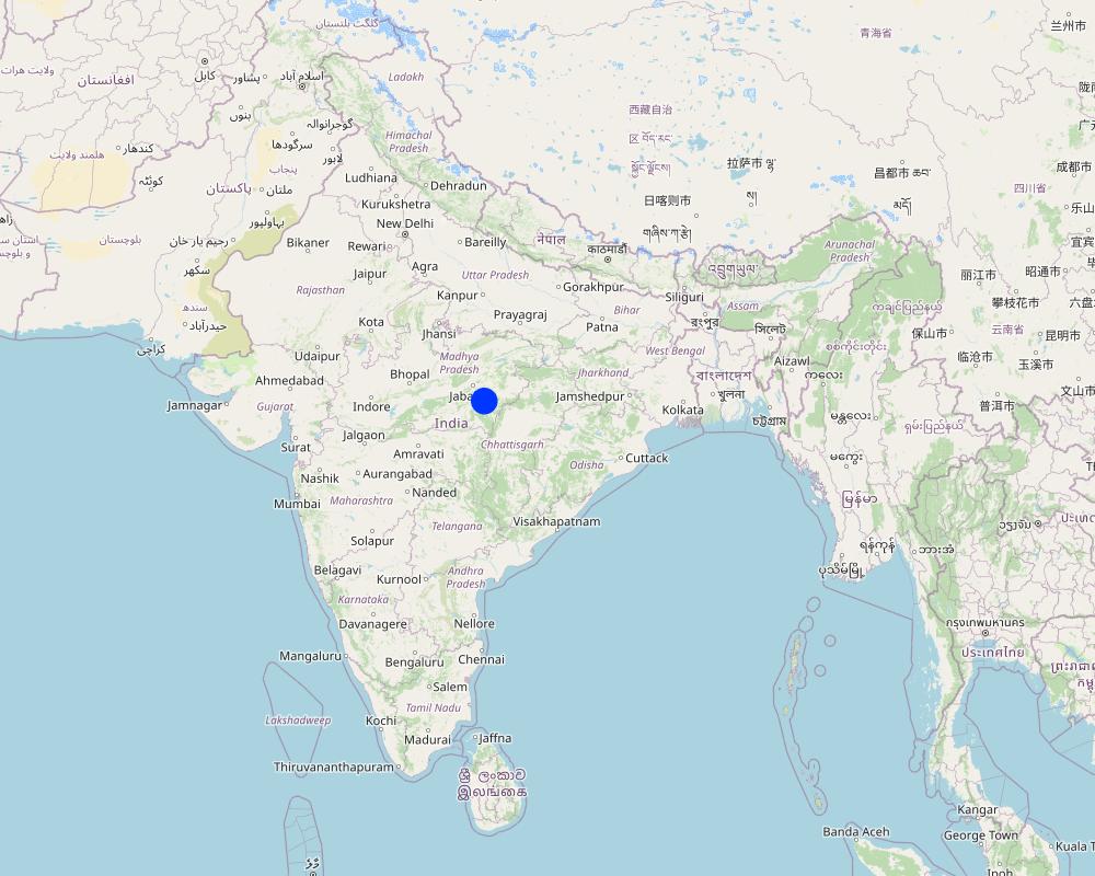
Более точная привязка места:
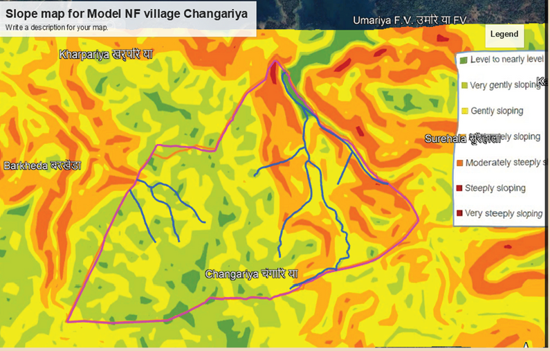
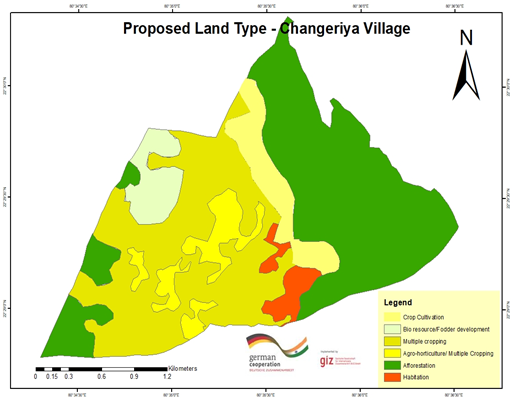
Changariya village, Bichiya block,
Комментарии:
The Changariya village is a sample site to understand the E-prakriti workbook approach
Map
×2.6 Даты начала и окончания реализации Подхода
Если год начала реализации Подхода достоверно неизвестен, дайте примерную оценку:
менее 10 лет назад (недавняя)
Год окончания (Если Подход больше не применяется):
2023
Комментарии:
This approach for landscape management considers the landscape as an administrative and natural unit and includes various levels such as Village, Block, District, and geo-hydrological landscapes. It provides a comprehensive activity plan for the management of natural resources, with a focus on natural farming as a core component. The approach is easy to understand and can be used for project implementation.
2.7 Тип Подхода
- в рамках проекта/ программы
2.8 Каковы цели/ задачи Подхода
The objective of this tool is to create a scientific and efficient approach for planning natural farming interventions through the use of GIS-based mapping
2.9 Условия содействующие применению Технологии/ Технологий в рамках Подхода или затрудняющие его
Социальные/ культурные/ религиозные нормы и ценности
- содействуют
E-prakriti proposes comprehensive planning by the adequate blending of technology with sustainability approaches, local wisdom, community participation and departmental convergence
Институциональные условия
- содействуют
The effective cooperation of actors like communities, Government Departments and other institutions is enabled by natural-farming planning approaches using GIS Tools.
Сотрудничество/ координация действий
- содействуют
The validation of GIS data is done through on-ground validation and extensive interpretation from maps. Community consultations are crucial in the planning process and convergence planning with the concerned Government Departments is necessary for comprehensive planning. Technical training in basic GIS-based software handling is essential for departmental engineers and other technically competent functionaries.
Осведомленность в области УЗП, доступность технической поддержки
- содействуют
Объем работ, доступность рабочей силы
- содействуют
e-Prakriti can significantly reduce the workload of planners and implementers as it reduces the need for physical visits to each and every village to collect ground-level data. A lot of data with very high accuracy can be collected from the satellite-based imaging systems.
3. Участие и распределение ролей заинтересованных сторон
3.1 Заинтересованные стороны, участвующие в реализации Подхода и их роли
- местные землепользователи/ местные сообщества
Local community members, farmers
They have provided the data and information during the ground proofing exercises
- организации местных сообществ
Local Community - Participation of local groups in implementing the program activities.
Community representatives from villages - support/drive the program's activities.
Community consultations are critical in promoting sustainable development interventions. It is vital to adequately prepare the community for the actions required, and community representatives must be involved at all planning levels, starting from the ground level. The principles of inclusivity and cooperation are crucial in building trust and promoting effective collaboration among community members.
The community's input is essential in creating a suitable action plan and developing maps at the beginning and end of the planning process through larger community consultations. By involving the community in this way, the intervention is more likely to be successful, sustainable and aligned with the community's needs and aspirations. This approach ensures that the community is adequately prepared to undertake the required actions and the intervention is more likely to have a positive impact on the community's well-being in the long run.
- эксперты по УЗП/ сельскому хозяйству
1. Team from GIZ and consultants who developed the e-Prakriti module
2. Specialist from project implementing team
SLM specialists from GIZ, from the implementing agency, other consultants from the domain of GIS and satellite-based applications have developed the e-Prakriti module. They have looked into the specific requirements for planning the natural farming interventions and available open source platforms to meet that requirement. Once this is developed they also did some ground truthing exercises in the field to observe the accuracy of collected data along with application in the field.
- учителя/ преподаватели/ школьники / студенты
Local Community Representative (Community Resource Person)
The CRP is trained to use the E-Prakriti tools for planning natural farming practices. He/she engages with village groups and the program team for planning, implementation and execution. They are considered the most important stakeholders in the process as it is expected that CRPs will use this tool in the planning of their activities.
- общественные организации
Foundation for Ecological Security (FES) NGO
FES is involved in piloting the approach in villages, handholding for the implementation and monitoring the work. Scaling up plans with different agencies is undertaken once the piloting is successful and evidence is generated.
- местные власти
Gram Panchayat (village self governing body)
Liaison with different government departments concerned viz. Departments like Water
Resource, NREGS, Animal Husbandry, Agriculture, Horticulture, Panchayat etc.
Convergence planning is crucial for the successful implementation of natural farming as it extensively relies on the utilization of common natural resources. This can only be achieved through the integrated effort of various concerned Departments, such as Water Resources, NREGS, Animal Husbandry, Agriculture, Horticulture, Panchayat, etc.
Therefore, it is essential to hold joint consultations with these departments to ensure that everyone is on the same page and has a shared understanding of the objectives and strategies for natural farming. These consultations can help to identify the potential areas of collaboration and the specific roles and responsibilities of each department in the implementation of natural farming practices.
In addition to engaging with the relevant departments, it is equally important to involve the district administration in the planning process. The District Collector, CEO of Zila, and Block Panchayat can play a facilitative role in bringing together the various departments and stakeholders involved in natural farming, promoting collaboration and convergence among them.
Through effective convergence planning, it is possible to achieve better coordination and utilization of resources, resulting in improved outcomes for natural farming. This will also contribute to the sustainable development of rural communities and the conservation of natural resources in the long run.
- международные организации
Deutsche Gesellschaft für Internationale Zusammenarbeit (GIZ) GmbH
Collated the experiences and prepared the workbook that gives an
overview of planning for natural farming using open-source data
3.2 Участие местных землепользователей/ местных сообществ на разных стадиях реализации Подхода
| Участие местных землепользователей/ местных сообществ | Перечислите участников и опишите их вовлеченность | |
|---|---|---|
| инициирование/ мотивация | пассивное | They have been discussed to understand their specific needs, resources availability and applications for developing the basic understanding |
| планирование | интерактивное | Local community institutions were involved in the process of planning to understand the local cost specifications, local cropping patterns and to collect and validate the data points |
| выполнение | самоорганизация | Local community institutions did implement the interventions with technical guidance from the project implementing team |
| мониторинг/ оценка | интерактивное | During the monitoring process images and data points collected from the satellites were physically validated from the community members. Also, discussions are held with communities to understand the social and economic impact of the project interventions. |
3.3 Схема реализации (если имеется)

Описание:
In order to effectively plan for natural farming using GIS tools, it is important to involve the larger systems around the community and the community itself. The first step is to identify and define a unit of intervention, such as a village. Open-source satellite data can then be used to understand and estimate various factors such as geomorphology and geohydrology. This data can be complemented with other available data from sources such as the Ground Water Board or the NREGS portal.
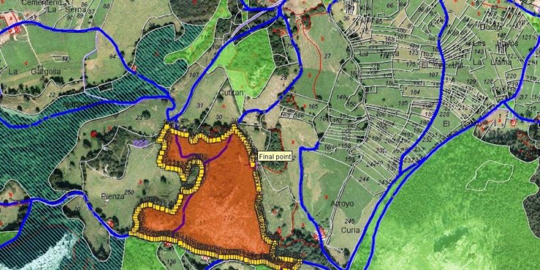
Using QGIS tool, the various data sets can be superimposed to find relationships between them. On-ground validation (truthing) of the GIS data is also necessary to ensure its accuracy. Once the data sets are gathered, an extensive interpretation from maps is undertaken, and the data is translated into easily understandable and implementable material for the community.
Community consultations are a critical part of the intervention, with community representatives being involved at all levels of planning. Inclusivity and cooperation are key principles in engaging the community and government departments and institutions for the judicious use of common resources. Larger community consultations are held at the beginning and end of the planning process to arrive at a suitable action plan using the prepared maps.
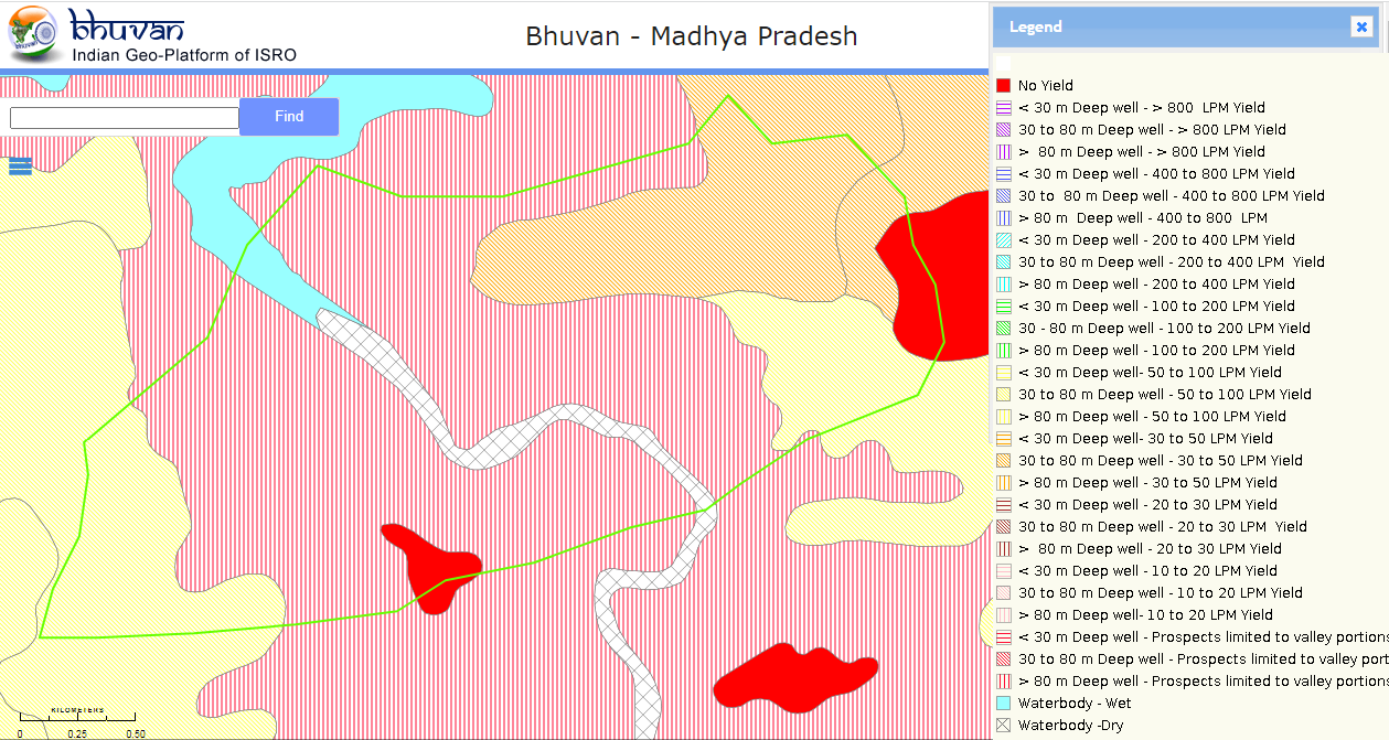
The planned actions and locations are plotted on maps on Google Earth, and convergence planning is necessary for the integrated efforts of several concerned departments. Joint consultations are held with these departments, and the district administration can play a facilitative role in bringing everyone on the same page. Lastly, it is important to train departmental engineers, Rozgar Sahayaks, and other technically competent functionaries in basic GIS-based software such as Bhuvan, QGIS, India-WRIS, and Bhuvan Panchayat to extract necessary data.
Автор:
Deutsche Gesellschaft für Internationale Zusammenarbeit (GIZ) GmbH
3.4 Принятие решений по выбору Технологии/ Технологий УЗП
Укажите, кто принимал решение по выбору применяемой Технологии/ Технологий:
- все участники как часть процесса совместных действий
Поясните на чём было основано принятие решений:
- результаты исследований
- личный опыт и мнения (незадокументированные)
4. Техническая поддержка, повышение компетенций и управление знаниями
4.1 Повышение компетенций/ обучение
Проводилось ли обучение землепользователей/ других заинтересованных лиц?
Да
Укажите, кто проходил обучение:
- местный персонал/консультанты
Если существенно, укажите гендерный и возрастной состав, статус, этническую принадлежность и т.д.
The Community resource person is trained on different maps and related interpretations. The first level of planning is made using open GIS sources which are later validated by the CRP along with the community in the village. Once the plan is finalized in a participatory manner, the program is implemented and monitored using the GIS tool.
Тип обучения:
- в ходе работы
- опытные участки
- курсы
Рассматриваемые темы:
1 Village boundaries
2 Village Assets and Infrastructure
3 Watershed / Sub-basin Map
4 Natural Drainage line
8 Availability of groundwater
5 Further resources on Water
5 Geomorphology
6 Slopes within the topography
7 Lineaments- cracks in the land for the generation of aquifiers
8 Soil Erosion
10 Soil kinds/data
11 Land usage pattern
12 Crop season land
13 Wastelands Map
Комментарии:
E-Prakriti is a training module which can be used by various stakeholders for the training and handholding of field team members.
4.2 Консультационные услуги
Есть ли у землепользователей возможность получать консультации?
Да
Укажите, где именно оказываются консультационные услуги:
- на полях землепользователей
4.3 Институциональная (организационная) поддержка
В ходе реализации Подхода были ли организованы новые институциональные структуры или поддержаны уже существующие?
- нет
4.4 Мониторинг и оценка
Являются ли мониторинг и оценка частью Подхода?
Да
Комментарии:
This tool can be used for monitoring the project interventions by having the pre- and post-project images from the satellite
Если да, будет ли данный документ использоваться для мониторинга и оценки?
Нет
4.5 Научные исследования
Были ли научные исследования частью Подхода?
Нет
5. Финансирование и внешняя материальная поддержка
5.1 Годовой бюджет мероприятий по УЗП в рамках Подхода
Если точный годовой бюжет неизвестен, укажите примерный диапазон затрат:
- < 2000
Комментарий (например, основные источники финансирования/ ключевые доноры):
The major cost involved is in developing the e-Prakriti module, the cost of which was incurred by the GIZ.
Another important cost component is capacity building of the stakeholders.
5.2 Финансирование и внешняя материальная поддержка, предоставляемая землепользователям
Предоставлялась ли землепользователям финансовая/ материальная поддержка для применения Технологии /Технологий?
Нет
5.3 Субсидии на отдельные затраты (включая оплату труда)
- нет
5.4 Кредитование
Предоставлялись ли в рамках Подхода кредиты на мероприятия УЗП?
Нет
5.5 Другие методы или инструменты стимулирования
Использовались ли другие методы или инструменты стимулирования для продвижения Технологий УЗП?
Да
Если да, поясните:
Training and handholding of stakeholders
6. Анализ влияния и заключительные положения
6.1 Влияние Подхода
Сумел ли Подход расширить возможности местных землепользователей, повысить участие заинтересованных сторон?
- Нет
- Да, немного
- Да, умеренно
- Да, существенно
The targeted areas that specifically needed conservation work were focused on
Сумел ли Подход дать возможность принимать решения на основе подтвержденных фактов?
- Нет
- Да, немного
- Да, умеренно
- Да, существенно
This has been the most important purpose of this approach. The use of various spatial tools ensured evidence-based decision-making
Сумел ли Подход помочь землепользователям внедрить и поддерживать технологии УЗП?
- Нет
- Да, немного
- Да, умеренно
- Да, существенно
The approach may be a great tool for effective and efficient natural farming-based practices and other SLM technologies
Сумел ли Подход улучшить согласованность действий и повысить рентабельность применения практик УЗП:
- Нет
- Да, немного
- Да, умеренно
- Да, существенно
Yes. It has been of great use
Сумел ли Подход мобилизовать/ расширить доступ к финансовым ресурсам для применения практик УЗП?
- Нет
- Да, немного
- Да, умеренно
- Да, существенно
Developing projects using the technology has ensured effective financial planning for the planned interventions
Сумел ли Подход расширить знания и возможности землепользователей в применении практик УЗП?
- Нет
- Да, немного
- Да, умеренно
- Да, существенно
Land users and local community resource persons learned about the various tools and technologies available for scientific planning
Сумел ли Подход расширить знания и возможности других заинтересованных сторон?
- Нет
- Да, немного
- Да, умеренно
- Да, существенно
Community resource persons
Сумел ли Подход укрепить сотрудничество между заинтересоваными сторонами/ выстроить механизмы сотрудничества?
- Нет
- Да, немного
- Да, умеренно
- Да, существенно
Stakeholders like farmers, FPOs, local community resource persons, NGOs, Government institutions all are in a position to apply a coordinated approach by using this tool
Сумел ли Подход снизить остроту конфликтов?
- Нет
- Да, немного
- Да, умеренно
- Да, существенно
Better mapping of resources could mitigate some conflicts among the community members
Сумел ли Подход содействать гендерному равенству и расширить права и возможности женщин и девочек?
- Нет
- Да, немного
- Да, умеренно
- Да, существенно
The promotion of natural farming empowers women members as they are core to it. Families get an access to safe and healthy foods as well.
Сумел ли Подход стимулировать молодежь/ будущее поколение землепользователей заниматься УЗП?
- Нет
- Да, немного
- Да, умеренно
- Да, существенно
Сумел ли Подход привести к более эффективному использованию электроэнергии/ возобновляемых источников энергии?
- Нет
- Да, немного
- Да, умеренно
- Да, существенно
Сумел ли Подход улучшить способность землепользователей адаптироваться к изменениям климата и смягчать последствия катастрофических погодных явлений?
- Нет
- Да, немного
- Да, умеренно
- Да, существенно
6.2 Основные причины, побуждающие землепользователей внедрять УЗП
- снижение объёма работ
The approach reduces the work load during the planning and monitoring stages
- экологическая сознательность
Natural farming, watershed management, efficient use of the resources
- приобретение знаний и опыта в области УЗП
6.3 Долгосрочная устойчивость мероприятий в рамках Подхода
Могут ли землепользователи самостоятельно (без внешней поддержки) продолжать применение того, что было реализовано в рамках Подхода?
- да
Если да, опишите как:
The approach developed is a guidebook, which can be used by anyone using the available open-access platform which is free to use
6.4 Сильные стороны/ преимущества Подхода
| Сильные стороны/ преимущества/ возможности по мнению землепользователей |
|---|
| Efficient mapping of the resources available to different stakeholders which sometimes community members may not be aware of |
| Convergence opportunities with different line departments once resources are mapped and activities are finalised |
| Reduced workload of the community members and their institutions as they need not be physically present every time |
| Сильные стороны/ преимущества/ возможности по мнению составителя или других ключевых специалистов |
|---|
| Scientific and evidence based method of planning with a lot of saving in time and resources with better accuracy. Sometimes connecting with communities as well as visiting field areas take a lot of time. |
| The approach can also be used for developing the financial outlays for the shortlisted interventions by getting the physical inputs, conducting the assessments through images and maps collected from open access platforms |
| The e-Prakriti approach can be very effective in the monitoring of the project interventions as satellite-based maps of pre- and post-interventions or geotagged images may provide scientific evidences |
6.5 Слабые стороны/ недостатки Подхода и пути их преодоления
| Слабые стороны/ недостатки/ риски по мнению землепользователей | Возможные пути их преодоления/снижения? |
|---|---|
| Not much exposed to this approach for planning | Handholding through demonstrations |
| Availability of computer devices to access the maps | Although computers are available at affordable prices in some cases, there may be financial support from the project or government agencies |
| Слабые стороны/ недостатки/ риски по мнению составителя или ответственных специалистов | Возможные пути их преодоления/снижения? |
|---|---|
| Technology keeps on updating thus the users need to update and upgrade themselves to ensure the usages at ground | Regular training and handholding of the users either physically or remotely |
| Availability of high speed internet for using the platforms; Currently most land users and CRPs do use internet using their mobile hotspots, access to wi-fi may may not be there | Identified planners or CRPs can be provided with internet devices or they can be linked with Wi-Fi available at different Government bodies |
7. Справочные материалы и ссылки
7.1 Методы сбора/источники информации
- опросы специалистов/экспертов по УЗП
2
- данные, собранные из отчетов и достоверных документов
2
7.3 Ссылки на материалы, доступные онлайн
Название/ описание:
e-Prakriti for comprehensive planning of natural farming practices
Адрес в сети Интернет:
Physical copy shared by GIZ
Ссылки и модули
Развернуть все Свернуть всеСсылки
Нет ссылок
Модули
Нет модулей