Vegetated graded soil bund [Эфиопия]
- Создание:
- Обновить:
- Составитель: Gizaw Desta Gessesse
- Редактор: –
- Рецензенты: Deborah Niggli, Alexandra Gavilano
Yeafer Erken (Amharic)
technologies_1601 - Эфиопия
Просмотреть разделы
Развернуть все Свернуть все1. Общая информация
1.2 Контактные данные специалистов и организаций, участвующих в описании и оценке Технологии
Название проекта, содействовавшего документированию/оценке Технологии (если применимо)
Water and Land Resource Centre Project (WLRC)1.3 Условия, регламентирующие использование данных, собранных ВОКАТ
Составитель и ответственный(-ые) специалист(-ы) согласны с условиями, регламентирующими использование собранных ВОКАТ данных:
Да
1.4 Декларация по устойчивости описываемой Технологии
Вызывает ли описанная здесь Технология проблемы деградации земель настолько, что ее нельзя назвать природосберегающей?
Нет
1.5 Ссылка на Анкету (ы) по Подходам УЗП (документируется с использованием ВОКАТ)
Community Organizations and Mobilization for Soil and Water … [Эфиопия]
Community mobilization for soil and water conservation work in a watershed planning unit is an approach for collective action by organizing all active labor forces living in the kebele/peasant association into development group of 20-30 members and further divide into 1:5 work force to implement construction of soil and water …
- Составитель: Gizaw Desta Gessesse
'Cut and Carry' Grazing system or 'Zero Grazing' … [Эфиопия]
Cut and carry grazing system (alternatively called zero grazing) is an approach where the community is consulted to identify and agree on areas to be closed and protected from free grazing; establish user groups are established to share the fodder biomass harvested from communal closed areas equitably; they utilize tree/shrub …
- Составитель: Gizaw Desta Gessesse
2. Описание Технологии УЗП
2.1 Краткое описание Технологии
Определение Технологии:
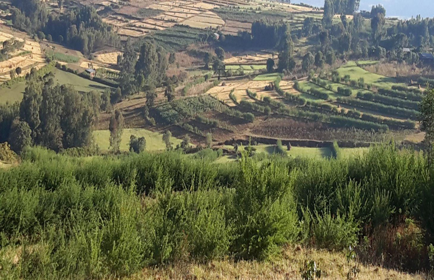
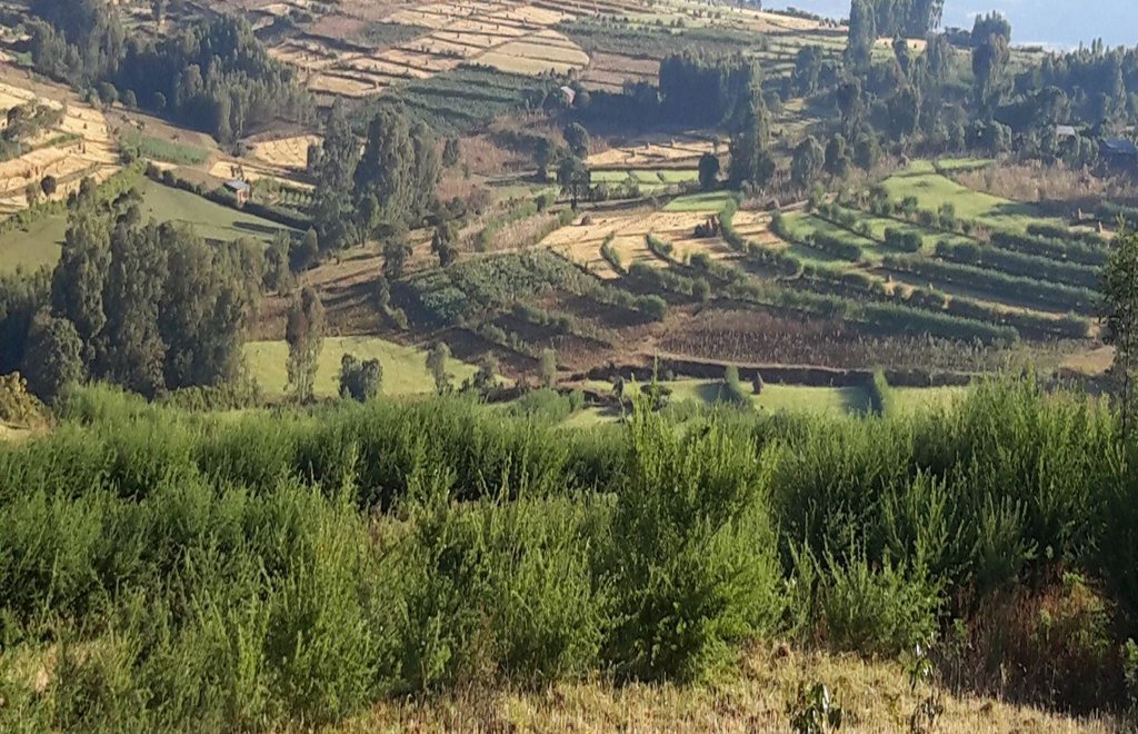
Vegetated graded soil bund is a soil conservation practice meant for cultivated lands and constructed by excavating graded channel on upper side and develop embankment on lower side which is planted with grass or shrub species in order to control soil erosion and drain excess runoff implemented through community mobilization.
2.2 Подробное описание Технологии
Описание:
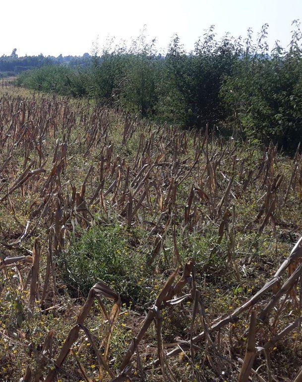
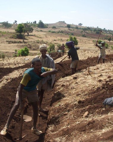
Vegetated graded soil bund is a practice or soil conservation technology for cultivated lands and constructed by excavating graded channel and form embankment. It is practiced in areas where there is excess runoff to be disposed and where there is no stones available for construction. The design specifications (ditch gradient, width and height) and layout (spacing/vertical interval) vary on the amount of excess runoff and slope of the land. Soil bund construction begins from top of the catchment. Cut off drains are constructed on top of the catchment and where needed to drain excess runoff to well stabilized natural or man-made waterways. this helps to reduce runoff impact on gullies. The bund ditch/channel should be sufficient enough to drain excess runoff safely without causing channel erosion and creating downstream damages. At same time the embankment should be stable to withstand overflows and damage due to free grazing. One technique to stabilize bunds is to plant the embankment with grass and shrub species of multiple economic value in order to compensate production area lost by bund construction. Often, the species are preferably used for livestock feed. Thus, free grazing has to be controlled. To protect damage of channels and embankments by extreme runoff and floods, frequent supervision and maintenance is required.
The purposes are:
1) Reduce nutrient loss and soil erosion by shortening the slope length,
2) Safely drain excess runoff from upstream of gully into protected waterways,
4) Produce biomass of fodder and cash values.
Vegetated graded bunds are established by doing surveying using hand level to determine the layout of the technology along the slope. During the surveying, the position of bunds (spacing) and cutoff drains and connection to waterways are determined. Bunds are laid following 0.05% gradient and up to 80 m maximum length. The specifications of the structure are: height of bund is a minimum of 60 cm after compaction; depending on the soil, base width range between 1.0 and 1.5m; top width is between 30 and 50 cm. The construction is made across different parcels owned by different land users. If there is no natural waterways and where it is appropriate, paved waterways are constructed at every 80 m or less bund length to dispose drainage water. At the beginning of the rainy season, the embankments are covered with grass and/or shrubs either by direct sowing of seeds or planting the seedlings raised in the nurseries. Monitoring of damages due to flooding and animals, maintenance of the structure as well as replanting of dead seedlings on bunds is required to sustain the soil conservation technology.
The technology is appropriately applied in high rainfall and sub-humid areas of the sub-tropics, particularly where the soil is moderately deep and poorly drained. It is constructed on cultivated lands having slopes in the range of 3-15%. The practice can be constructed by land users. It also requires collective decision and actions to drain excess runoff through waterways. The living condition depends on subsistence crop-livestock mixed farming. On average households have 5-6 family size. Crop production is meant for home consumption with small surplus for local market. The services related to water supply, energy supply, and infrastructure are low. Besides it is an asset, animals often used to cope shocks during drought periods.
2.3 Фотографии, иллюстрирующие Технологию
2.5 Страна/ регион/ места, где применяется Технология, информация о которых собрана в данной Анкете
Страна:
Эфиопия
Административная единица (Район/Область):
Amhara National Regional State (ANRS)
Более точная привязка места:
Mecha, Bahirdar Zuria and Yilmana Densa
Пояснения:
Total area covered by the SLM Technology is 20 km2.
The technology is applied on specific conditions within the watersheds or area of adoption
2.6 Сколько лет применяется данная Технология
Если год начала применения Технологии достоверно неизвестен, дайте примерную оценку:
- менее 10 лет назад (недавняя)
2.7 Внедрение Технологии
Укажите, как именно Технология УЗП была внедрена:
- через проекты/ внешнее вмешательство
Пояснения (тип проекта и т.д.):
The soil bunds are introduced before 30-40 years, however the integration of structural and combination of vegetative measures are applied in three years period in the WLRC learning watersheds.
3. Классификация Технологии УЗП
3.1 Основные цели и задачи реализации Технологии
- снижение или предотвращение деградации земель, восстановление нарушенных земель
3.2 Текущий(-ие) тип(-ы) землепользования на территории, где применяется Технология

Пахотные угодья и плантации
- Однолетние культуры
- Многолетние (недревесные) культуры
- Древесные и кустарниковые культуры
- Rhamnus, Napier grass
- Cordia Africana, Polycantha, Sesbania Susban, Pigeon pea, Treelucer
Число урожаев за год:
- 1
Поясните:
Longest growing period in days: 210, Longest growing period from month to month: June-December; Second longest growing period in days: 180, Second longest growing period from month to month: June-November

Пастбищные угодья
- free grazing
Пояснения:
Major land use problems (compiler’s opinion): Land degradation due to sheet erosion, rills and gullies, soil nutrient depletion, overgrazing, shortage of fuel wood, excessive removal of crop residuals, loss of vegetation and deforestation
Major land use problems (land users’ perception): Soil erosion, soil nutrient depletion, shortage of pasture
3.4 Водоснабжение
Обеспеченность водой участков, где реализуется Технология :
- полное орошение
3.5 Категория УЗП, к которой относится Технология
- мероприятия по влагозадержанию и снижению эрозии почв на склонах
3.6 Мероприятия УЗП, выполняемые в рамках Технологии

Мероприятия с использованием растительности
- Р1: Древесный и кустарниковый покров
- Р2: Злаковые и многолетние травянистые растения

инженерные мероприятия
- И2: Насыпи, валы
- И3: Ступенчатые канавы (арыки), каналы, водотоки
Пояснения:
Type of vegetative measures: aligned: -graded strips
3.7 Основные проблемы деградации земель, на решение которых направлена Технология

водная эрозия почв
- ВЭп: поверхностная эрозия/смыв верхних почвенных горизонтов
- ВЭд: косвенное воздействие водной эрозии

деградация водных ресурсов
- Вуп: изменение объема поверхностного стока
Пояснения:
Main causes of degradation: soil management (High tillage frequency on annual basis and steep slope cultivation), crop management (annual, perennial, tree/shrub) (The cropping system is cereal based that induce erosion), overgrazing (Livestock graze on crop residues after harvesting of crops), Heavy / extreme rainfall (intensity/amounts) (Extreme rainfall cause for high erosion), other natural causes (avalanches, volcanic eruptions, mud flows, highly susceptible natural resources, extreme topography, etc.) specify (Steep slopes or rugged topography), population pressure (Result in expansion of crop lands to steeper slopes)
Secondary causes of degradation: deforestation / removal of natural vegetation (incl. forest fires) (Deforestation of scattered trees in the farm and forests upstream of crop lands), land tenure (Insecure tenure play role not to invest on long term), poverty / wealth (Poor can not afford to invest on soil conservation on his parcel), education, access to knowledge and support services, governance / institutional
3.8 Предотвращение и снижение деградации земель, или восстановление нарушенных земель
Укажите цель Технологии по отношению к деградации земель :
- снижение деградации земель
4. Технические характеристики, мероприятия по практической реализации, вложения и стоимость
4.1 Технический рисунок, иллюстрирующий Технологию
Спецификация (пояснения к техническому рисунку):
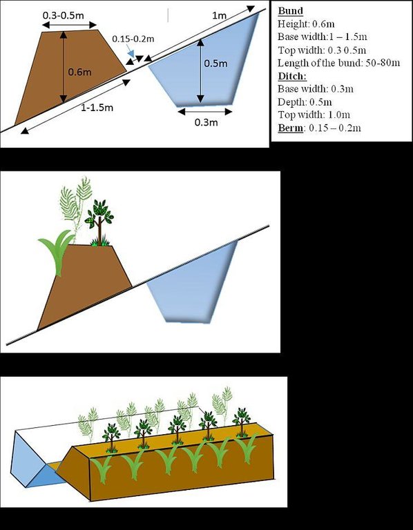
Vegetated graded soil bund showing the excavated ditch or channel and the embankment planted with grass and shrubs
Location: Amhara Region. Mecha, Yilmana Densa, Bahir Dar Zuria and Dessie Z
Technical knowledge required for field staff / advisors: high (Layout and design specification of soil bunds and cutoff drains vary on soil types, slopes, and rainfall conditions. Experts thus should acquire knowledge on specific hydrologic conditions)
Technical knowledge required for land users: moderate (Land users need skill to layout and construct bunds, monitor structures before the occurrence of excessive damage, and do regular maintenance)
Main technical functions: control of dispersed runoff: impede / retard, reduction of slope length, sediment retention / trapping, sediment harvesting, increase of biomass (quantity)
Secondary technical functions: control of dispersed runoff: retain / trap, reduction of slope angle, increase / maintain water stored in soil, increase of groundwater level / recharge of groundwater
Aligned: -graded strips
Vegetative material: T : trees / shrubs, C : perennial crops, G : grass
Number of plants per (ha): T=5333, C=160, G=1600
Vertical interval between rows / strips / blocks (m): 1-1.5
Spacing between rows / strips / blocks (m): 10-20
Vertical interval within rows / strips / blocks (m): T=0.3, C=5, G=0.5
Width within rows / strips / blocks (m): 0.3
Trees/ shrubs species: Cordia Africana, Polycantha, Sesbania Susban, Pigeon pea, Treelucer
Perennial crops species: Rhamnus
Grass species: Napier grass
Slope (which determines the spacing indicated above): 3-15%
Gradient along the rows / strips: 0.05%
Diversion ditch/ drainage
Depth of ditches/pits/dams (m): 0.3-0.7
Width of ditches/pits/dams (m): 1.2-2.8
Length of ditches/pits/dams (m): 100-250
Waterway
Depth of ditches/pits/dams (m): 0.3
Width of ditches/pits/dams (m): 1.5-2.0
Bund/ bank: graded
Vertical interval between structures (m): 1-1.5
Spacing between structures (m): 10-20
Depth of ditches/pits/dams (m): 0.5
Width of ditches/pits/dams (m): 0.3
Height of bunds/banks/others (m): 0.6
Width of bunds/banks/others (m): 1-1.5
Length of bunds/banks/others (m): 50-80
Construction material (earth): in-situ excavated soil
Slope (which determines the spacing indicated above): 3-15%
Lateral gradient along the structure: 0.05%
Vegetation is used for stabilisation of structures.
Автор:
Bekure Melesse, WLRC, P.O.Box 8707, Addis Ababa, Ethiopia
4.2 Общая информация по необходимым вложениям и стоимости
другая/ национальная валюта (название):
ETH BIRR
Если это необходимо, укажите обменный курс от доллара США к местной валюте (например, 1 доллар США = 79,9 бразильского реала): 1 доллар США =:
20,0
Укажите среднюю дневную заработную плату наемных работников:
2.50
4.3 Мероприятия, необходимые для начала реализации
| Деятельность | Время (сессия) | |
|---|---|---|
| 1. | Preparing planting materials | January-May |
| 2. | Preparation of planting materials | January-May |
| 3. | Transportation of grass splits/cuttings | Start of rainy season/July |
| 4. | Transporting tree seedlings | Start of rain season/July |
| 5. | Planting grass splits/cuttings | Start of rainy season/July |
| 6. | Sowing seeds on bunds | Start of rainy season/July |
| 7. | Planting tree seedlings on bunds | Starting of rainy season/July |
| 8. | Surveying (layout of structures) | After crop harvest and before first tillage operation |
| 9. | Construction of cutoff drains | January-April |
| 10. | Construction of bunds (ditch and embankment) | January-April |
| 11. | Construction of waterways | January - April |
4.4 Вложения и затраты, необходимые для начала реализации
| Опишите затраты | Единица | Количество | Затраты на единицу | Общая стоимость на единицу | % затрат, оплаченных землепользователями | |
|---|---|---|---|---|---|---|
| Оплата труда | labour | ha | 1,0 | 1107,0 | 1107,0 | 79,0 |
| Оборудование | animal traction | ha | 1,0 | 4,0 | 4,0 | 100,0 |
| Оборудование | tools | ha | 1,0 | 300,6 | 300,6 | 50,0 |
| Посадочный материал | seedlings | ha | 1,0 | 32,0 | 32,0 | 100,0 |
| Посадочный материал | seeds | ha | 1,0 | 9,0 | 9,0 | 100,0 |
| Посадочный материал | compost manure | ha | 1,0 | 2,0 | 2,0 | 100,0 |
| Строительные материалы | stone | ha | 1,0 | 1300,0 | 1300,0 | 100,0 |
| Строительные материалы | wood | ha | 1,0 | 110,0 | 110,0 | 100,0 |
| Строительные материалы | earth | ha | 1,0 | 25,2 | 25,2 | 100,0 |
| Общая стоимость запуска Технологии | 2889,8 | |||||
| Общие затраты на создание Технологии в долларах США | 144,49 | |||||
Пояснения:
Duration of establishment phase: 15 month(s)
4.5 Поддержание/ текущее обслуживание
| Деятельность | Сроки/ повторяемость проведения | |
|---|---|---|
| 1. | Preparation of planting materials | January - May |
| 2. | Transportation of seedlings | July |
| 3. | Re-plantation of seedlings and grass splits | July |
| 4. | Maintenance of bunds, cutoff drain and waterways | January-April |
4.6 Стоимость поддержания/ текущего обслуживания ( в год)
| Опишите затраты | Единица | Количество | Затраты на единицу | Общая стоимость на единицу | % затрат, оплаченных землепользователями | |
|---|---|---|---|---|---|---|
| Оплата труда | labour | ha | 1,0 | 279,0 | 279,0 | 100,0 |
| Посадочный материал | seedlings | ha | 1,0 | 20,0 | 20,0 | 100,0 |
| Общая стоимость поддержания Технологии | 299,0 | |||||
| Общие затраты на поддержание Технологии в долларах США | 14,95 | |||||
Пояснения:
Machinery/ tools: Cart, plastic tubes, spade, pickaxe, hand level, graduated ranging pole, spade, pickaxe, crowbar, hammer
The costs are calculated based on the labour, seedling/seed, grass splits required per hectare
4.7 Наиболее значимые факторы, влияющие на стоимость затрат
Опишите наиболее значимые факторы, влияющие на стоимость затрат:
The cost variation in implementing vegetated soil bund is dependent upon availability of stones, workability of the soil, cost of seeds or seedlings for plantation, and distance for transporting seedlings.
5. Природные и социально-экономические условия
5.1 Климат
Среднегодовое количество осадков
- < 250 мм
- 251-500 мм
- 501-750 мм
- 751-1000 мм
- 1001-1500 мм
- 1501-2000 мм
- 2001-3000 мм
- 3001-4000 мм
- > 4000 мм
Пояснения/ комментарии по осадкам:
Monsoon, 5-6 months rain and 6-7 dry months
Агроклиматическая зона
- Умеренно-влажная
Thermal climate class: subtropics. he lowest temperature is above 5oc but below 18oc etween November to January
5.2 Рельеф
Склоны (преобладающие):
- пологие (0-2%)
- покатые (3-5%)
- покато-крутые (6-10%)
- крутые (11-15%)
- очень крутые (16-30%)
- чрезвычайно крутые (31-60%)
- обрывистые (>60%)
Формы рельефа:
- плато/ равнины
- гребни хребтов/холмов
- склоны гор
- склоны холмов
- подножья
- днища долин
Зона высотной поясности:
- 0-100 м над уровнем моря
- 101-500 м н.у.м.
- 501-1000 м н.у.м.
- 1001-1500 м н.у.м.
- 1501-2000 м н.у.м.
- 2001-2500 м н.у.м.
- 2501-3000 м н.у.м.
- 3001-4000 м н.у.м.
- > 4 тыс. м н.у.м.
5.3 Почвы
Средняя мощность почв:
- поверхностные (0-20 см)
- неглубокие (21-50 см)
- умеренно глубокие (51-80 см)
- глубокие (81-120 см)
- очень глубокие (> 120 см)
Гранулометрический состав (верхнего горизонта):
- средние фракции (суглинистый, супесчаный)
- тонкодисперсный/ тяжёлый (глинистый)
Содержание органического вещества в верхнем горизонте:
- среднее (1-3%)
- низкое (< 1%)
5.4 Доступность и качество воды
Уровень грунтовых вод:
5-50 м
Доступность поверхностных вод:
средняя
Качество воды (без обработки):
питьевая вода плохого качества (необходима обработка)
5.5 Биоразнообразие
Видовое разнообразие:
- низкое
5.6 Характеристика землепользователей, применяющих Технологию
Рыночная ориентация производства:
- натуральное хозяйство (самообеспечение)
- смешанный (натуральный / коммерческий)
Доходы из других источников:
- < 10% всех доходов
Относительный уровень достатка:
- плохой
- средний
Индивидуальное или коллективное хозяйство:
- частное/ домовладение
Уровень механизации:
- ручной труд
- тягловая сила
Пол:
- женщины
- мужчины
Укажите другие важные характеристики землепользователей:
Land users applying the Technology are mainly common / average land users
Difference in the involvement of women and men: Women are involved in the construction of bunds with role of collecting stones, stabilize/compact the embankments and sometimes help men in excavating the earth
Population density: 200-500 persons/km2
Annual population growth: 2% - 3%
80% of the land users are average wealthy.
20% of the land users are poor.
Off-farm income specification: Land users often do not have access to off-farm income unless those who are young and own small size of land go for seasonal labor to towns during the slack period
5.7 Средняя площадь земель, используемых землепользователями с применением Технологии
- < 0,5 га
- 0,5-1 га
- 1-2 га
- 2-5 га
- 5-15 га
- 15-50 га
- 50-100 га
- 100-500 га
- 500-1000 га
- 1000-10000 га
- > 10000 га
Считается ли это мелким, средним или крупным хозяйством (по местным масштабам)?
- мелкое
5.8 Собственность на землю, права на земле- и водопользование
Землевладелец:
- государственная
Право землепользования:
- индивидуальное
Право водопользования:
- неограниченное (неконтролируемое)
- общинное (контролируемое)
5.9 Доступ к базовым услугам и инфраструктуре
медицинское обслуживание:
- плохой
- средний
- хорошая
образование:
- плохой
- средний
- хорошая
технические консультации:
- плохой
- средний
- хорошая
занятость (вне хозяйства):
- плохой
- средний
- хорошая
рынки:
- плохой
- средний
- хорошая
электроснабжение:
- плохой
- средний
- хорошая
транспорт и дорожная сеть:
- плохой
- средний
- хорошая
водоснабжение и канализация:
- плохой
- средний
- хорошая
финансовые услуги:
- плохой
- средний
- хорошая
6. Воздействия и заключительные положения
6.1 Влияние Технологии УЗП в пределах территории ее применения
Социально-экономическое воздействие
Продуктивность
производство сельскозяйственных культур
Комментарий/ пояснения:
Crop yield increase on sedimentation area of bunds
производство кормов
Комментарий/ пояснения:
Introduction of fodder crops on bunds
качество кормов
Комментарий/ пояснения:
Introduction of high value forage crops
площадь, используемая для производства продукции
Комментарий/ пояснения:
The area used for ditch construction can be taken as a loss of land
управление землями
Комментарий/ пояснения:
In slope classes where spacing is narrow farm operation will be hindered
Доходы и затраты
доходы хозяйства
Комментарий/ пояснения:
Increase in income due to yield increase and fodder production
Социальное и культурное воздействие
местное самоуправление
Комментарий/ пояснения:
Watershed users committee established to regulate the development
знания в области УЗП/ деградации земель
Комментарий/ пояснения:
Field staffs and land users aware of erosion and soil conservation
смягчение конфликтов
contribution to human well-being
Комментарий/ пояснения:
The technology aim to reduce the soil loss and improving the soil moisture to produce crops. On the other hand, the fodder production on bunds increase livestock productivity. Through improving crop and livestock productivity the livelihood of the watershed people is improved in long terms.
Экологическое воздействие
Водный цикл/ поверхностный сток
количество воды
Комментарий/ пояснения:
Overall effect of bunds show increase in surface water downstreams
поверхностный сток
Комментарий/ пояснения:
reduction of concentrated runoff
Почвы
влажность почв
Комментарий/ пояснения:
Increase the rate of infiltration
утрата почв
Комментарий/ пояснения:
Soil loss is reduced by breaking the slope length
6.2 Влияние Технологии за пределами территории ее применения
надежность и постоянство водотоков
Комментарий/ пояснения:
In good drainage soils it increases infiltrated water and interflows
подтопление ниже по течению
Комментарий/ пояснения:
Since it helps to reduce concentration of runoff it contributes to reduce flooding
отложение наносов ниже по течению
Комментарий/ пояснения:
The main function of bunds is to reduce soil loss
ущерб прилегающим полям
Комментарий/ пояснения:
All fields are treated with integrated bund, cutoff drain and waterways
6.3 Подверженность и чувствительность Технологии УЗП к постепенным изменениям климата и экстремальным погодным явлениям/ стихийным бедствиям, связанным с изменением климата (в понимании землепользователей)
Экстремальные явления, связанные с изменением климата (стихийные бедствия)
Погодные стихийные бедствия
| Насколько успешно Технология справляется с этим? | |
|---|---|
| местные ливневые дожди | хорошо |
Гидрологические стихийные бедствия
| Насколько успешно Технология справляется с этим? | |
|---|---|
| регулярные наводнения (выход рек из берегов) | плохо |
Пояснения:
The technology has sufficient drainage ditch to tolerate excess runoff occurred during heavy rainfall events. However, it is sensitive to floods unless flood management measures such as strong cutoff drains and waterways are implemented
6.4 Анализ эффективности затрат
Насколько получаемый результат сопоставим с первоначальными вложениями (с точки зрения землепользователей)?
Эффективность затрат в краткосрочной перспективе:
слабо позитивное
Эффективность затрат в долгосрочной перспективе:
позитивное
Насколько получаемый результат сопоставим с текущими расходами по поддержанию технологии (с точки зрения землепользователей)?
Эффективность затрат в краткосрочной перспективе:
позитивное
Эффективность затрат в долгосрочной перспективе:
очень позитивное
Пояснения:
The short term economic benefits of the technology includes increase in fodder production and slightly crop productivity due to improved soil moisture. Whereas the long term benefit can be obtained as a result of increased yield on areas where sediment accumulation occurs as well as production of fodder on soil bunds for livestock feed
6.5 Внедрение Технологии
Пояснения:
The technology is implemented using community mobilization approach which involves all land users. All land users, who cultivate land in areas where bunds are suitable, implemented the technology. All parcels are covered with the technology/bunds except homesteads and degraded hillsides and gullies which are treated with different SLM technologies
Since the approach encourages collective action (through community organizations) to integrate different SLM technologies in the watershed level, there is no attempt by individual land users. However, there are motivations and implementation of land users on adjacent watersheds to implement the technology.
There is a moderate trend towards spontaneous adoption of the Technology
The trend is at increasing rate although land users need material support such as multipurpose seedlings to stabilize bunds. There is shortage of supply of fodder seeds. Community nurseries are inadequate and not well supported to raise seedlings to meet community demands.
6.7 Сильные стороны/ преимущества/ возможности Технологии
| Сильные стороны/ преимущества/ возможности по мнению землепользователей |
|---|
| Increase in fodder production for livestock feed |
| Reduce conflict among adjacent land users (i.e., upstream and downstream land users) that arise due to concentrated runoff |
| Reduce soil erosion |
| Сильные стороны/ преимущества/ возможности по мнению составителя или других ключевых специалистов |
|---|
| The technology reduces soil loss and associated nutrient loss significantly in the first 3 to 4 years and further reduce siltation of reservoirs and land degradation |
| Increase the soil moisture in the landscape/watershed |
| Improves the greenness, soil carbon and micro-climate |
| Increase level of awareness of land users to produce fodder and diversify production and income |
| Reduce the concentration of runoff and safely drain without causing damage |
6.8 Слабые стороны/ недостатки/ риски Технологии и пути их преодоления
| Слабые стороны/ недостатки/ риски по мнению землепользователей | Возможные пути их преодоления/снижения? |
|---|---|
| Hinder farm operations like turning oxen become difficult while ploughing | It can be sustained through proper layout and allow space for human and animal paths |
| Plantation on bunds harbor birds | This can be avoided by harvesting the mature branches of the shrubs for livestock feed on seasonal basis. |
| Appearance of new weeds species along the drainage ditches | Regular weed monitoring and manual control |
| Hinders livestock to graze on crop residues | Try to use cut and carry grazing system (both crop residues and fodders) and develop forage development strategies in every possible niches |
| Слабые стороны/ недостатки/ риски по мнению составителя или ответственных специалистов | Возможные пути их преодоления/снижения? |
|---|---|
| High labor requirement to establish and maintain the technology | Increase the awareness level of land users and strength collective actions and local organizational setups |
| Small land loss for construction | Introduce production options (like fodder production) on bunds to compensate the lost land |
| It requires some years to accumulate sediment on bund area and form bench | It can be improved by modifying the design of drainage ditchs |
7. Справочные материалы и ссылки
7.1 Методы сбора/ источники информации
- выезды на места, полевые обследования
- опросы землепользователей
Когда были собраны данные (на местах)?
12/05/2014
7.2 Ссылки на опубликованные материалы
Название, автор, год публикации, ISBN:
Vegetated Graded Soil Bund: A Technique to Reduce Runoff Impact and Increase Soil Moisture Storage and Fodder Biomass, WLRC Brief No. 4
Где опубликовано? Стоимость?
WWW.wlrc-eth.org
Ссылки и модули
Развернуть все Свернуть всеСсылки

Community Organizations and Mobilization for Soil and Water … [Эфиопия]
Community mobilization for soil and water conservation work in a watershed planning unit is an approach for collective action by organizing all active labor forces living in the kebele/peasant association into development group of 20-30 members and further divide into 1:5 work force to implement construction of soil and water …
- Составитель: Gizaw Desta Gessesse

'Cut and Carry' Grazing system or 'Zero Grazing' … [Эфиопия]
Cut and carry grazing system (alternatively called zero grazing) is an approach where the community is consulted to identify and agree on areas to be closed and protected from free grazing; establish user groups are established to share the fodder biomass harvested from communal closed areas equitably; they utilize tree/shrub …
- Составитель: Gizaw Desta Gessesse
Модули
Нет модулей


