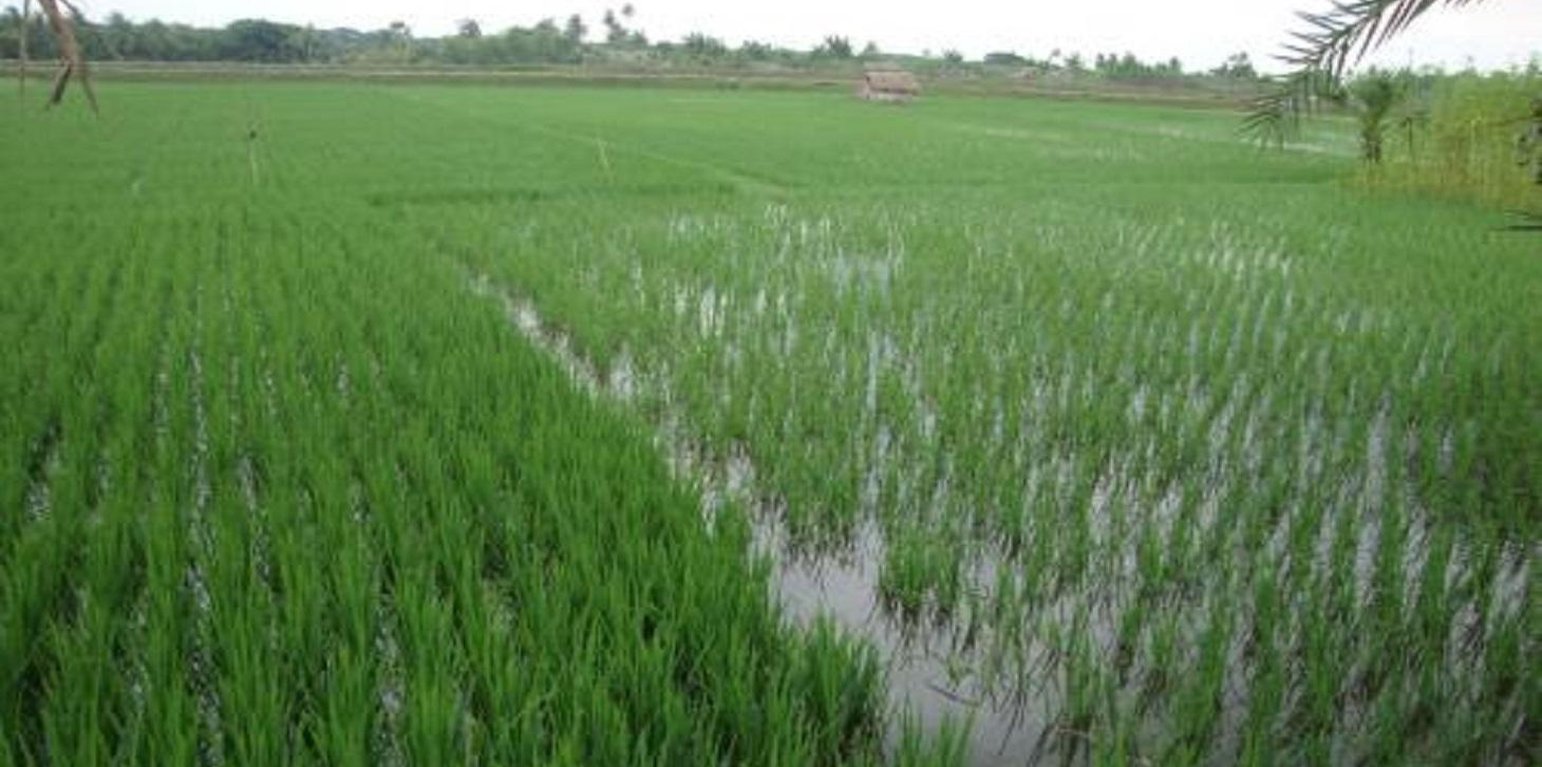
Transplanted Aman and Boro cultivated Area (Shoaib JU)

Usage of Gher boundary for cropping (บังกลาเทศ)

Gherer bunder upar nana prokar shakshabjee uthpadon

คำอธิบาย

Gher (shrimp cultivation) boundary usage for multiple cropping.

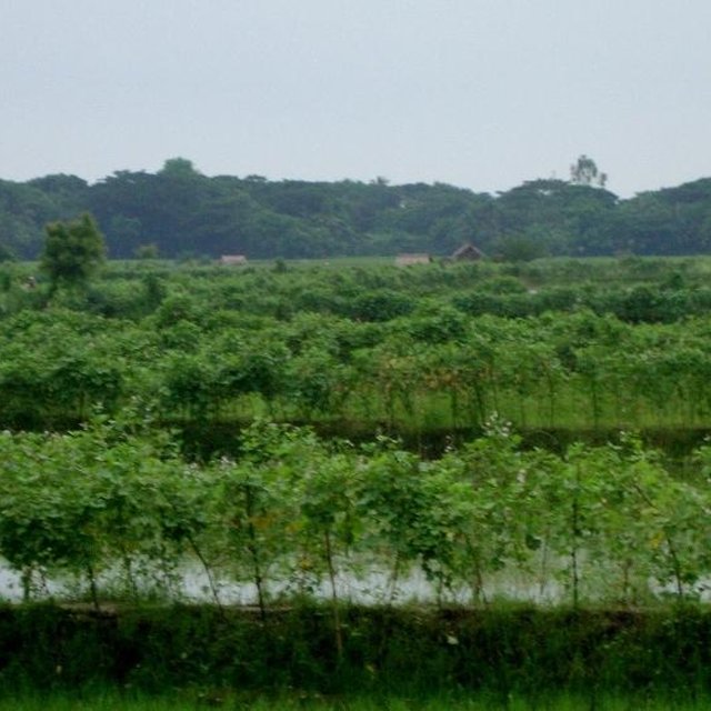
Gher is a local word used for shrimp cultivation plot. The boundaries of these ghers are nowadays raised and maintained to grow vegetables, fruits and also some tree species. In this case the boundary of the plot is raised at least 3 feet with grest width 1 feet plus depending on the height of the boundary (Bund/dyke). Within the gher the land is used for both sweet water prawn (Golda) or saline water prawn (Bagda) with other different types of fishes (locally called Sada Mach) if suitable depending on the salinity of water. Some of the gher lands are used for transplanted Aman with shrimp/fishes.
Farmers dug a ditch along the boundary or in any corner of the field or at the center of the plot to preserve water and fishes during the dry season. In some of the cases the farmers used shallow tube well water to sustain the fishes. In non-to slightly saline areas they used it even for boro (winter rice).

Purpose of the Technology: The purpose of this technology is a boundary which is used for various types of crops, including year round vegetables and land for rice and fishes including shrimps.

Establishment / maintenance activities and inputs: The boundary is constructed above flood level (2-3 feet), the width is approx. 2-3 feet, the ditches are 2-3 feet deep along the boundary or at the corner or at the center.
To grow vegetables farmers used nylon nets for creeping supported by the bamboo or Dhaincha or strings.
Top soils kept on top of the bunds to avoid relatively less fertile soil on the bunds.
Main inputs are seeds of vegetables, nets, bamboo, strings, fingerlings of fish etc.

Natural / human environment: The salinity of the soils from the bunds is washed away by rainwater, which facilitates vegetable production: Rain water desolves salt and moves to the bottom of the bund, and soil becomes non-saline or slightly saline where vegetable could be grown.

สถานที่

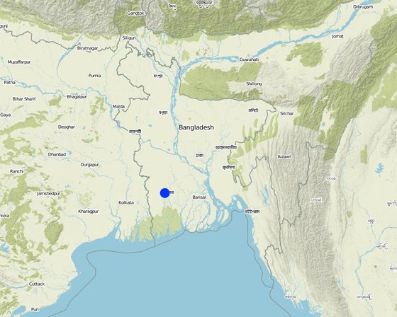
สถานที่: Khulna, Bangladesh Southern region, บังกลาเทศ

ตำนวนการวิเคราะห์เทคโนโลยี:

ตำแหน่งทางภูมิศาสตร์ของสถานที่ที่ถูกเลือ
  • 89.41395, 22.80719

การเผยแพร่ของเทคโนโลยี: กระจายไปอย่างสม่ำเสมอในพื้นที่ (approx. 1-10 ตร.กม.)

วันที่ในการดำเนินการ: น้อยกว่า 10 ปี (ไม่นานนี้)

ประเภทของการแนะนำ
Beans and cucumber on bunds (Shoaib JU)
Landscape of Gher area in Coastal region (ShoaibJU (Former CSO, SRDI, Bangladesh))

การจำแนกประเภทเทคโนโลยี

จุดประสงค์หลัก
  • ปรับปรุงการผลิตให้ดีขึ้น
  • ลด ป้องกัน ฟื้นฟู การเสื่อมโทรมของที่ดิน
  • อนุรักษ์ระบบนิเวศน์
  • ป้องกันพื้นที่ลุ่มน้ำ/บริเวณท้ายน้ำ โดยร่วมกับเทคโนโลยีอื่นๆ
  • รักษาสภาพหรือปรับปรุงความหลากหลายทางชีวภาพ
  • ลดความเสี่ยงของภัยพิบัติ
  • ปรับตัวเข้ากับการเปลี่ยนแปลงภูมิอากาศของโลก สภาพภูมิอากาศที่รุนแรงและผลกระทบ
  • ชะลอการเปลี่ยนแปลงภูมิอากาศของโลกและผลกระทบ
  • สร้างผลกระทบทางด้านเศรษฐกิจที่เป็นประโยชน์
  • สร้างผลกระทบทางด้านสังคมที่เป็นประโยชน์
การใช้ที่ดิน

  • พื้นที่ปลูกพืช - การปลูกพืชล้มลุกอายุปีเดียว
  • การใช้ที่ดินแบบผสมผสาน (รวมถึงวนเกษตร) - อื่น ๆ (ระบุ): Cropland and aquaculture
การใช้น้ำ
  • จากน้ำฝน
  • น้ำฝนร่วมกับการชลประทาน
  • การชลประทานแบบเต็มรูปแบบ

จำนวนของฤดูปลูกต่อปี: 1
การใช้ที่ดินก่อนการดำเนินการโดยเทคโนโลยี: Mixed: Mo: Other
ความหนาแน่นของปศุสัตว์: n.a.
ความมุ่งหมายที่เกี่ยวข้องกับการเสื่อมโทรมของที่ดิน
  • ป้องกันความเสื่อมโทรมของที่ดิน
  • ลดความเสื่อมโทรมของดิน
  • ฟื้นฟูบำบัดที่ดินที่เสื่อมโทรมลงอย่างมาก
  • ปรับตัวกับสภาพความเสื่อมโทรมของที่ดิน
  • ไม่สามารถใช้ได้
ที่อยู่ของการเสื่อมโทรม
  • การเสื่อมโทรมของดินทางด้านเคมี - Cs (Salinization/alkalinization): การสะสมเกลือหรือการทำให้เป็นด่าง
กลุ่ม SLM
  • การเลี้ยงผึ้ง การเพาะเลี้ยงสัตว์น้ำ สัตว์ปีก ฟาร์มกระต่าย ฟาร์มหนอนไหม
มาตรการ SLM
  • มาตรการจัดการพืช - A1: พืช/สิ่งปกคลุมดิน
  • มาตรการอนุรักษ์ด้วยโครงสร้าง - S2: ทำนบ เขื่อนดิน
  • มาตรการอนุรักษ์ด้วยการจัดการ - M1: การเปลี่ยนรูปแบบของการใช้ประโยชน์ที่ดิน

แบบแปลนทางเทคนิค

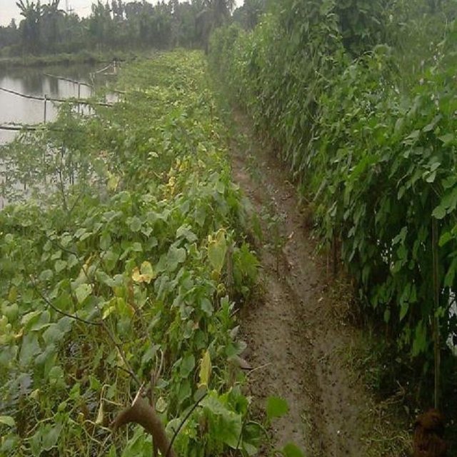
ข้อมูลจำเพาะด้านเทคนิค
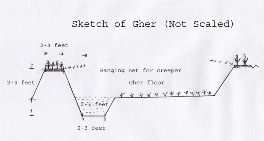
ผู้เขียน Shoaib Jalal
The gher boundary is raised approximately 2-3 feet with a crest of 2-3 feet. A ditch also dug to store water and fish during dry season.

Location: Dumuria. Khulna

Date: 03-09-13

Technical knowledge required for field staff / advisors: moderate (It is only land manipulation.)

Technical knowledge required for land users: moderate (Previously farmer did not put the top soil on the top of the bunds. That impedes crop production on bunds.)

Main technical functions: increase in nutrient availability (supply, recycling,…), water harvesting / increase water supply, improvement of water quality, buffering / filtering water, promotion of vegetation species and varieties (quality, eg palatable fodder), spatial arrangement and diversification of land use, Decrease of soil salinity, Increase of options for growing more crops

Agronomic measure: Top soil kept on top

Structural measure: Bunds
Height of bunds/banks/others (m): 1
Width of bunds/banks/others (m): 0.5-1
Length of bunds/banks/others (m): 10-50

Construction material (earth): Bunds are raised by piling earth

Change of land use practices / intensity level: Bunds are used for year round cropping

การจัดตั้งและการบำรุงรักษา: กิจกรรม ปัจจัยและค่าใช้จ่าย

การคำนวนต้นทุนและค่าใช้จ่าย
  • ค่าใช้จ่ายถูกคำนวน
  • สกุลเงินที่ใช้คำนวณค่าใช้จ่าย Taka
  • อัตราแลกเปลี่ยน (ไปเป็นดอลลาร์สหรัฐ) คือ 1 ดอลลาร์สหรัฐ = 79.0 Taka
  • ค่าจ้างเฉลี่ยในการจ้างแรงงานต่อวันคือ ไม่มีคำตอบ
ปัจจัยที่สำคัญที่สุดที่มีผลต่อค่าใช้จ่าย
Availability of labour
กิจกรรมเพื่อการจัดตั้ง
  1. Farmers cut the earth from adjacent lands (ช่วงระยะเวลา/ความถี่: Nov-Dec)
ปัจจัยและค่าใช้จ่ายของการจัดตั้ง
ปัจจัยนำเข้า หน่วย ปริมาณ ค่าใช้จ่ายต่อหน่วย (Taka) ค่าใช้จ่ายทั้งหมดต่อปัจจัยนำเข้า (Taka) %ของค่าใช้จ่ายที่ก่อให้เกิดขึ้นโดยผู้ใช้ที่ดิน
แรงงาน
Farmers cut the earth from adjacent lands ha 10.0 65.0 650.0 100.0
Labour ha 2.0 300.0 600.0 100.0
Watch and ward ha 1.0 300.0 300.0 100.0
อุปกรณ์
Seeds, nets etc ha 1.0 50.0 50.0 100.0
ปุ๋ยและสารฆ่า/ยับยั้งการเจริญเติบโตของสิ่งมีชีวิต (ไบโอไซด์)
Fertilizer ha 1.0 5.0 5.0 100.0
ค่าใช้จ่ายทั้งหมดของการจัดตั้งเทคโนโลยี 1'605.0
กิจกรรมสำหรับการบำรุงรักษา
  1. Transplanting seedlings/seeds (ช่วงระยะเวลา/ความถี่: July/Nov)
  2. Cultural practices (ช่วงระยะเวลา/ความถี่: Aug-Oct/Dec-March)
ปัจจัยและค่าใช้จ่ายของการบำรุงรักษา
ปัจจัยนำเข้า หน่วย ปริมาณ ค่าใช้จ่ายต่อหน่วย (Taka) ค่าใช้จ่ายทั้งหมดต่อปัจจัยนำเข้า (Taka) %ของค่าใช้จ่ายที่ก่อให้เกิดขึ้นโดยผู้ใช้ที่ดิน
แรงงาน
Transplanting seedlings/seeds persons/day/ha 2.0 10.0 20.0 100.0
ค่าใช้จ่ายทั้งหมดของการบำรุงรักษาสภาพเทคโนโลยี 20.0

สิ่งแวดล้อมทางธรรมชาติ

ปริมาณน้ำฝนเฉลี่ยรายปี
  • < 250 ม.ม.
  • 251-500 ม.ม.
  • 501-750 ม.ม.
  • 751-1,000 ม.ม.
  • 1,001-1,500 ม.ม.
  • 1,501-2,000 ม.ม.
  • 2,001-3,000 ม.ม.
  • 3,001-4,000 ม.ม.
  • > 4,000 ม.ม.
เขตภูมิอากาศเกษตร
  • ชื้น
  • กึ่งชุ่มชื้น
  • กึ่งแห้งแล้ง
  • แห้งแล้ง
ข้อมูลจำเพาะเรื่องภูมิอากาศ
Most of the rainfall experienced in rainy season
Thermal climate class: tropics
ความชัน
  • ราบเรียบ (0-2%)
  • ลาดที่ไม่ชัน (3-5%)
  • ปานกลาง (6-10%)
  • เป็นลูกคลื่น (11-15%)
  • เป็นเนิน (16-30%)
  • ชัน (31-60%)
  • ชันมาก (>60%)
ภูมิลักษณ์
  • ที่ราบสูง/ที่ราบ
  • สันเขา
  • ไหล่เขา
  • ไหล่เนินเขา
  • ตีนเนิน
  • หุบเขา
ความสูง
  • 0-100 เมตร
  • 101-500 เมตร
  • 501-1,000 เมตร
  • 1,001-1,500 เมตร
  • 1,501-2,000 เมตร
  • 2,001-2,500 เมตร
  • 2,501-3,000 เมตร
  • 3,001-4,000 เมตร
  • > 4,000 เมตร
เทคโนโลยีถูกประยุกต์ใช้ใน
  • บริเวณสันเขา (convex situations)
  • บริเวณแอ่งบนที่ราบ (concave situations)
  • ไม่เกี่ยวข้อง
ความลึกของดิน
  • ตื้นมาก (0-20 ซ.ม.)
  • ตื้น (21-50 ซ.ม.)
  • ลึกปานกลาง (51-80 ซ.ม.)
  • ลึก (81-120 ซ.ม.)
  • ลึกมาก (>120 ซ.ม.)
เนื้อดิน (ดินชั้นบน)
  • หยาบ/เบา (ดินทราย)
  • ปานกลาง (ดินร่วน ทรายแป้ง)
  • ละเอียด/หนัก (ดินเหนียว)
เนื้อดิน (> 20 ซม. ต่ำกว่าพื้นผิว)
  • หยาบ/เบา (ดินทราย)
  • ปานกลาง (ดินร่วน ทรายแป้ง)
  • ละเอียด/หนัก (ดินเหนียว)
สารอินทรียวัตถุในดิน
  • สูง (>3%)
  • ปานกลาง (1-3%)
  • ต่ำ (<1%)
น้ำบาดาล
  • ที่ผิวดิน
  • <5 เมตร
  • 5-50 เมตร
  • > 50 เมตร
ระดับน้ำบาดาลที่ผิวดิน
  • เกินพอ
  • ดี
  • ปานกลาง
  • ไม่ดีหรือไม่มีเลย
คุณภาพน้ำ (ยังไม่ได้รับการบำบัด)
  • เป็นน้ำเพื่อการดื่มที่ดี
  • เป็นน้ำเพื่อการดื่มที่ไม่ดี (จำเป็นต้องได้รับการบำบัด)
  • เป็นน้ำใช้เพื่อการเกษตรเท่านั้น (การชลประทาน)
  • ใช้ประโยชน์ไม่ได้
ความเค็มของน้ำเป็นปัญหาหรือไม่?
  • ใช่
  • ไม่ใช่

การเกิดน้ำท่วม
  • ใช่
  • ไม่ใช่
ความหลากหลายทางชนิดพันธุ์
  • สูง
  • ปานกลาง
  • ต่ำ
ความหลากหลายของแหล่งที่อยู่
  • สูง
  • ปานกลาง
  • ต่ำ

ลักษณะเฉพาะของผู้ใช้ที่ดินที่ประยุกต์ใช้เทคโนโลยี

เป้าหมายทางการตลาด
  • เพื่อการยังชีพ (หาเลี้ยงตนเอง)
  • ผสม (การเลี้ยงชีพ/ทำการค้า)
  • ทำการค้า/การตลาด
รายได้จากภายนอกฟาร์ม
  • < 10% ของรายได้ทั้งหมด
  • 10-50% ของรายได้ทั้งหมด
  • > 50% ของรายได้ทั้งหมด
ระดับของความมั่งคั่งโดยเปรียบเทียบ
  • ยากจนมาก
  • จน
  • พอมีพอกิน
  • รวย
  • รวยมาก
ระดับของการใช้เครื่องจักรกล
  • งานที่ใช้แรงกาย
  • การใช้กำลังจากสัตว์
  • การใช้เครื่องจักรหรือเครื่องยนต์
อยู่กับที่หรือเร่ร่อน
  • อยู่กับที่
  • กึ่งเร่ร่อน
  • เร่ร่อน
เป็นรายบุคคลหรือกลุ่ม
  • เป็นรายบุคคล/ครัวเรือน
  • กลุ่ม/ชุมชน
  • สหกรณ์
  • ลูกจ้าง (บริษัท รัฐบาล)
เพศ
  • หญิง
  • ชาย
อายุ
  • เด็ก
  • ผู้เยาว์
  • วัยกลางคน
  • ผู้สูงอายุ
พื้นที่ที่ใช้ต่อครัวเรือน
  • < 0.5 เฮกตาร์
  • 0.5-1 เฮกตาร์
  • 1-2 เฮกตาร์
  • 2-5 เฮกตาร์
  • 5-15 เฮกตาร์
  • 15-50 เฮกตาร์
  • 50-100 เฮกตาร์
  • 100-500 เฮกตาร์
  • 500-1,000 เฮกตาร์
  • 1,000-10,000 เฮกตาร์
  • >10,000 เฮกตาร์
ขนาด
  • ขนาดเล็ก
  • ขนาดกลาง
  • ขนาดใหญ่
กรรมสิทธิ์ในที่ดิน
  • รัฐ
  • บริษัท
  • เป็นแบบชุมชนหรือหมู่บ้าน
  • กลุ่ม
  • รายบุคคล ไม่ได้รับสิทธิครอบครอง
  • รายบุคคล ได้รับสิทธิครอบครอง
สิทธิในการใช้ที่ดิน
  • เข้าถึงได้แบบเปิด (ไม่ได้จัดระเบียบ)
  • เกี่ยวกับชุมชน (ถูกจัดระเบียบ)
  • เช่า
  • รายบุคคล
สิทธิในการใช้น้ำ
  • เข้าถึงได้แบบเปิด (ไม่ได้จัดระเบียบ)
  • เกี่ยวกับชุมชน (ถูกจัดระเบียบ)
  • เช่า
  • รายบุคคล
เข้าถึงการบริการและโครงสร้างพื้นฐาน
สุขภาพ

จน
x
ดี
การศึกษา

จน
x
ดี
ความช่วยเหลือทางด้านเทคนิค

จน
x
ดี
การจ้างงาน (เช่น ภายนอกฟาร์ม)

จน
x
ดี
ตลาด

จน
x
ดี
พลังงาน

จน
x
ดี
ถนนและการขนส่ง

จน
x
ดี
น้ำดื่มและการสุขาภิบาล

จน
x
ดี
บริการด้านการเงิน

จน
x
ดี

ผลกระทบ

ผลกระทบทางด้านเศรษฐกิจและสังคม
การผลิตพืชผล
ลดลง
x
เพิ่มขึ้น


Desalinized soil of the bund

ผลกระทบด้านสังคมและวัฒนธรรม
ความมั่นคงด้านอาหาร / พึ่งตนเองได้
ลดลง
x
ปรับปรุงดีขึ้น

สถานการณ์ด้านสุขภาพ
แย่ลง
x
ปรับปรุงดีขึ้น

โอกาสทางวัฒนธรรม (ด้านจิตวิญญาณ ทางศาสนา ด้านสุนทรียภาพ)
ลดลง
x
ปรับปรุงดีขึ้น


Cash from vegetables

การบรรเทาความขัดแย้ง
แย่ลง
x
ปรับปรุงดีขึ้น


Conflicts to use water resource

สถานการณ์ของกลุ่มด้อยโอกาส ทางด้านสังคมและเศรษฐกิจ (เพศ อายุ สถานภาพ ความเป็นกลุ่มทางชาติพันธุ์)
แย่ลง
x
ปรับปรุงดีขึ้น

ผลกระทบด้านนิเวศวิทยา
การระบายน้ำส่วนเกิน
ลดลง
x
ปรับปรุงดีขึ้น


Ghers are ponded and no water can be drained

ความเค็ม
เพิ่มขึ้น
x
ลดลง


+ Soil salinity reduced as washed by rainwater -> found in soils of Gher bunds

- Due to ground water abstraction -> found in coastal regions, increasing trend

ความหลากหลายทางชีวภาพของพืช
ลดลง
x
เพิ่มขึ้น

การปล่อยคาร์บอนและก๊าซเรือนกระจก
เพิ่มขึ้น
x
ลดลง

ผลกระทบนอกพื้นที่ดำเนินการ

รายได้และค่าใช้จ่าย

ผลประโยชน์ที่ได้รับเปรียบเทียบกับค่าใช้จ่าย
ผลตอบแทนระยะสั้น
ด้านลบอย่างมาก
x
ด้านบวกอย่างมาก

ผลตอบแทนระยะยาว
ด้านลบอย่างมาก
x
ด้านบวกอย่างมาก

ผลประโยชน์ที่ได้รับเปรียบเทียบกับค่าใช้จ่ายในการบำรุงรักษา
ผลตอบแทนระยะสั้น
ด้านลบอย่างมาก
x
ด้านบวกอย่างมาก

ผลตอบแทนระยะยาว
ด้านลบอย่างมาก
x
ด้านบวกอย่างมาก

Long term benefit is yet to be observed

การเปลี่ยนแปลงของสภาพภูมิอากาศ

การเปลี่ยนแปลงสภาพภูมิอากาศที่ค่อยเป็นค่อยไป
อุณหภูมิประจำปี เพิ่มขึ้น

ไม่ดี
x
ดีมาก
สภาพรุนแรงของภูมิอากาศ (ภัยพิบัติ)
พายุฝนประจำท้องถิ่น

ไม่ดี
x
ดีมาก
พายุลมประจำท้องถิ่น

ไม่ดี
x
ดีมาก

การน้อมเอาความรู้และการปรับใช้

เปอร์เซ็นต์ของผู้ใช้ที่ดินในพื้นที่ที่นำเทคโนโลยีไปใช้
  • ครั้งเดียวหรือเป็นการทดลอง
  • 1-10%
  • 10-50%
  • มากกว่า 50%
จากทั้งหมดที่ได้รับเทคโนโลยีเข้ามามีจำนวนเท่าใดที่ทำแบบทันที โดยไม่ได้รับการจูงใจด้านวัสดุหรือการเงินใดๆ?
  • 0-10%
  • 10-50%
  • 50-90%
  • 90-100%
เทคโนโลยีได้รับการปรับเปลี่ยนเร็วๆ นี้เพื่อให้ปรับตัวเข้ากับสภาพที่กำลังเปลี่ยนแปลงหรือไม่?
  • ใช่
  • ไม่ใช่
สภาพที่กำลังเปลี่ยนแปลงอันไหน?
  • การเปลี่ยนแปลงแบบค่อยเป็นค่อยไปและสภาพรุนแรงของภูมิอากาศ
  • การเปลี่ยนแปลงของตลาด
  • การมีแรงงานไว้ให้ใช้ (เนื่องจากการอพยพย้ายถิ่นฐาน)

บทสรุปหรือบทเรียนที่ได้รับ

จุดแข็ง: มุมมองของผู้ใช้ที่ดิน
  • Growing more crops will benefit the farmer with more return. As of now marketing of the goods are facilitated by local small entrepreneurs. Most of them have poor linkage with broader markets.

    How can they be sustained / enhanced? These entrepreneurs could be appropriately linked with bigger one at regional levels (Upazila/ Districts). At the same time road net works are to be alleviated to facilitate access of transport to carry farmers good with all securities.
จุดแข็ง: ทัศนคติของผู้รวบรวมหรือวิทยากรคนอื่นๆ
  • Land could be used as farmers are managing themselves

    How can they be sustained / enhanced? To sustain production and produce such as vegetables and fishes deserve uninterrupted marketing linkage essential.
  • Changes in land management by the farmer to grow multiple crops indeed scale up their economy than before.

    How can they be sustained / enhanced? To sustain the farming system good variety and quality seeds supply will enhance the scenario.
จุดด้อย/ข้อเสีย/ความเสี่ยง: มุมมองของผู้ใช้ที่ดินแก้ไขปัญหาได้อย่างไร
  • Water management of the areas became critical, specially sweet water Good water management system is to be introduced through local and regional planning.
  • Conflicts of land uses are prominent. Social awareness and concept of land zoning seems to be essentials at all levels.
จุดด้อย/ข้อเสีย/ความเสี่ยง: ทัศนคติของผู้รวบรวมหรือวิทยากรคนอื่นๆแก้ไขปัญหาได้อย่างไร
  • Due to construction or rearrangement of field bunds (Dykes) almost all drainages ways blocked. Consequently the whole area became water logged. This situation will definitely aggravate soil quality, environment and ultimate ecosystem Community approach to manage the landscape will be effective. In this regard local administration and community leaders can play a vital role.
  • Soils of Gher boundaries (Dykes) are subject to erosion when exposed to rain water. Good cover crops and management are necessary to protect soils from erosion. At same time farmers may be trained on this issue.

การอ้างอิง

ผู้รวบรวม
  • Jalal Uddin Md. Shoaib
Editors
ผู้ตรวจสอบ
  • David Streiff
วันที่จัดทำเอกสาร: 6 กันยายน 2013
การอัพเดทล่าสุด: 28 พฤษภาคม 2017
วิทยากร
คำอธิบายฉบับเต็มในฐานข้อมูล WOCAT
ข้อมูล SLM ที่ถูกอ้างอิง
การจัดทำเอกสารถูกทำโดย
องค์กร โครงการ
This work is licensed under Creative Commons Attribution-NonCommercial-ShareaAlike 4.0 International