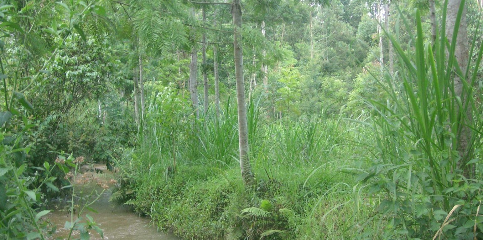
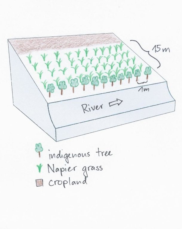
Trees stabilizing the riverbank, Napier grass in the back. (Manuel Fischer (Manyatta, Embu))

Productive use of the riparian area using Napier grass and protection of the riverbank with indigenous trees at Kapingazi River (เคนยา)

คำอธิบาย

A riparian area that is frequently flooded requires a special treatment because conventional agriculture is not possible. Trees along the riverbank and Napier grass on the remaining space still allow a productive use despite the difficult circumstances.

On the southeastern slopes of Mt. Kenya, the circumstances are ideal for agricultural activities, the rains are plenty and normally reliable. The plot owner started realizing a problem of riverbank degradation 17 years ago. But still he continued the traditional way of agriculture, planting beans and maize. Since his plot is on the slip-off slope only few metres above the river level, it experienced regular floods in case of heavy rainfalls, destroying the plants and leading to crop failures. Conventional plants like maize and beans do not resist such an excess of water. To fight the land loss and the bad harvest, the farmer introduced indigenous trees along the river and Napier fighting the riverbank degradation. Behind that, several rows of the flood resistant Napier grass were planted to still use the area in a productive way.

Purpose of the Technology: Above all, the goal of this technology is to get a high grass production. As a side effect results a quite good protection of the riparian area. The vegetation prevents rainwater from running directly from the fields into the water. Therefore, the chemicals from the field get stuck in the riparian soils and don't pollute the river. In the same way the infiltration in the riparian enlarges the total infiltration since the water would go to the river directly. Especially the raw surface of the riparian allows more infiltration and interception storage of water. This surplus of stored water is able to provide river water for a longer period, when rains are humble for a longer period. In case of floods, the increased infiltration potential can cut the peak flow and thus prevent damages. The grass yield is used as a fodder for the cows.

Establishment / maintenance activities and inputs: Before planting the indigenous trees, water guzzlers like eucalyptus trees were cut down. Indigenous seedlings were planted right along the river at a distance of 1 m. Behind the tree row, Napier grass is planted and harvested twice a year. The cutting and harvesting of the grass is done regularly such that animals can be provided with fodder every day. As soon as the trees are big enough, they function as a source of fire wood, they can be pruned every 5 months.

Natural / human environment: The studied plot is situated between the tea and the coffee zone at an elevation of 1663 m.a.s.l. This small-scale farm does not produce tea nor coffee, there is mainly subsistence agricultural production and some few products are sold on the market. Rainfall is reliable and ensures a regular production.

สถานที่

สถานที่: Embu, Kenya/Eastern Province, เคนยา

ตำนวนการวิเคราะห์เทคโนโลยี:

ตำแหน่งทางภูมิศาสตร์ของสถานที่ที่ถูกเลือ
  • 37.47201, -0.42611

การเผยแพร่ของเทคโนโลยี: กระจายไปอย่างสม่ำเสมอในพื้นที่ (0.00075 km²)

In a permanently protected area?:

วันที่ในการดำเนินการ: 10-50 ปี

ประเภทของการแนะนำ
Ground stabilizing Napier grass that is used for fodder. (Manuel Fischer (Manyatta))

การจำแนกประเภทเทคโนโลยี

จุดประสงค์หลัก
  • ปรับปรุงการผลิตให้ดีขึ้น
  • ลด ป้องกัน ฟื้นฟู การเสื่อมโทรมของที่ดิน
  • อนุรักษ์ระบบนิเวศน์
  • ป้องกันพื้นที่ลุ่มน้ำ/บริเวณท้ายน้ำ โดยร่วมกับเทคโนโลยีอื่นๆ
  • รักษาสภาพหรือปรับปรุงความหลากหลายทางชีวภาพ
  • ลดความเสี่ยงของภัยพิบัติ
  • ปรับตัวเข้ากับการเปลี่ยนแปลงภูมิอากาศของโลก สภาพภูมิอากาศที่รุนแรงและผลกระทบ
  • ชะลอการเปลี่ยนแปลงภูมิอากาศของโลกและผลกระทบ
  • สร้างผลกระทบทางด้านเศรษฐกิจที่เป็นประโยชน์
  • สร้างผลกระทบทางด้านสังคมที่เป็นประโยชน์
การใช้ที่ดิน
Land use mixed within the same land unit: ใช่ - การปลูกพืชร่วมกับปศุสัตว์และการทำป่าไม้ (Agro-silvopastoralism)

  • พื้นที่ปลูกพืช
    • การปลูกพืชล้มลุกอายุปีเดียว: fodder crops - grasses
    • การปลูกไม้ยืนต้น ไม้พุ่ม
    จำนวนของฤดูเพาะปลูกต่อปี: 2
  • ทุ่งหญ้าเลี้ยงสัตว์
    • ตัดแล้วขนไป / ไม่มีการปล่อยแทะเล็มเอง (Cut-and-carry / zero grazing)
  • ป่า/พื้นที่ทำไม้
การใช้น้ำ
  • จากน้ำฝน
  • น้ำฝนร่วมกับการชลประทาน
  • การชลประทานแบบเต็มรูปแบบ

ความมุ่งหมายที่เกี่ยวข้องกับการเสื่อมโทรมของที่ดิน
  • ป้องกันความเสื่อมโทรมของที่ดิน
  • ลดความเสื่อมโทรมของดิน
  • ฟื้นฟูบำบัดที่ดินที่เสื่อมโทรมลงอย่างมาก
  • ปรับตัวกับสภาพความเสื่อมโทรมของที่ดิน
  • ไม่สามารถใช้ได้
ที่อยู่ของการเสื่อมโทรม
  • การกัดกร่อนของดินโดยน้ำ - Wt (Loss of topsoil): การสูญเสียดินชั้นบนหรือการกัดกร่อนที่ผิวดิน , Wr (Riverbank erosion): การกัดกร่อนริมฝั่งแม่น้ำ
  • การเสื่อมโทรมของดินทางด้านชีวภาพ - Bs (Quality and species composition): องค์ประกอบหรือความหลากหลายทางคุณภาพและชนิดพันธุ์ลดลง
  • การเสื่อมโทรมของน้ำ - Hp (Decline of surface water quality): การลดลงของคุณภาพน้ำที่ผิวดิน
กลุ่ม SLM
  • การปรับปรุงพันธุ์พืชหรือพันธุ์สัตว์ต่าง ๆ
มาตรการ SLM
  • มาตรการอนุรักษ์ด้วยวิธีพืช - V1: ต้นไม้และพุ่มไม้คลุมดิน, V2: หญ้าและไม้ยืนต้น

แบบแปลนทางเทคนิค

ข้อมูลจำเพาะด้านเทคนิค
A tree row is aligned directly beside the riverbed with a spacing of 1m. Directly behind the trees, Napier grass is planted up to a width of 15m. Adjacent to the Napier grass, there is cropland.

Location: Manyatta. Embu West / Eastern Province

Date: 28.12.2013

Technical knowledge required for field staff / advisors: low

Technical knowledge required for land users: low

Main technical functions: stabilisation of soil (eg by tree roots against land slides), improvement of water quality, buffering / filtering water

Secondary technical functions: improvement of ground cover, increase of biomass (quantity)

Aligned: -along boundary
Vegetative material: T : trees / shrubs
Vertical interval within rows / strips / blocks (m): 1

Scattered / dispersed
Vegetative material: G : grass
Spacing between rows / strips / blocks (m): 0.8
Vertical interval within rows / strips / blocks (m): 0.8

Trees/ shrubs species: Grevillea, Mutundu, Miburu, Mulinga, Mugumo

Grass species: Napier Grass

Slope (which determines the spacing indicated above): 0%
Author: Manuel Fischer

การจัดตั้งและการบำรุงรักษา: กิจกรรม ปัจจัยและค่าใช้จ่าย

การคำนวนต้นทุนและค่าใช้จ่าย
  • ค่าใช้จ่ายถูกคำนวน ต่อหน่วยเทคโนโลยี
  • สกุลเงินที่ใช้คำนวณค่าใช้จ่าย USD
  • อัตราแลกเปลี่ยน (ไปเป็นดอลลาร์สหรัฐ) คือ 1 ดอลลาร์สหรัฐ = ไม่มีคำตอบ
  • ค่าจ้างเฉลี่ยในการจ้างแรงงานต่อวันคือ 3.33
ปัจจัยที่สำคัญที่สุดที่มีผลต่อค่าใช้จ่าย
n.a.
กิจกรรมเพื่อการจัดตั้ง
  1. Chopping bad trees (ช่วงระยะเวลา/ความถี่: anytime)
  2. Tree planting (ช่วงระยะเวลา/ความถี่: rainy season)
  3. Planting of Napier grass (ช่วงระยะเวลา/ความถี่: Beginning of rainy season)
ปัจจัยและค่าใช้จ่ายของการจัดตั้ง
ปัจจัยนำเข้า หน่วย ปริมาณ ค่าใช้จ่ายต่อหน่วย (USD) ค่าใช้จ่ายทั้งหมดต่อปัจจัยนำเข้า (USD) %ของค่าใช้จ่ายที่ก่อให้เกิดขึ้นโดยผู้ใช้ที่ดิน
แรงงาน
Chopping bad trees Persons/day 2.5 3.2 8.0 100.0
Tree planting Persons/day 5.0 3.6 18.0 100.0
Planting of Napier grass Persons/day 2.0 2.75 5.5 100.0
วัสดุด้านพืช
Seedling Pieces 70.0 0.114285 8.0 100.0
ค่าใช้จ่ายทั้งหมดของการจัดตั้งเทคโนโลยี 39.5
Total costs for establishment of the Technology in USD 39.5
กิจกรรมสำหรับการบำรุงรักษา
  1. Adding manure (ช่วงระยะเวลา/ความถี่: 2 times a month)
  2. Harvest of Napier (ช่วงระยะเวลา/ความถี่: 2 times per year after rainy season)
  3. Pruning (ช่วงระยะเวลา/ความถี่: None)
ปัจจัยและค่าใช้จ่ายของการบำรุงรักษา
ปัจจัยนำเข้า หน่วย ปริมาณ ค่าใช้จ่ายต่อหน่วย (USD) ค่าใช้จ่ายทั้งหมดต่อปัจจัยนำเข้า (USD) %ของค่าใช้จ่ายที่ก่อให้เกิดขึ้นโดยผู้ใช้ที่ดิน
แรงงาน
Adding manure Persons/day 0.2 2.25 0.45 100.0
Harvest of Napier Persons/day 2.0 3.3333 6.67 100.0
Prunning Persons/day 2.0 3.25 6.5 100.0
ค่าใช้จ่ายทั้งหมดของการบำรุงรักษาสภาพเทคโนโลยี 13.62
Total costs for maintenance of the Technology in USD 13.62

สิ่งแวดล้อมทางธรรมชาติ

ปริมาณน้ำฝนเฉลี่ยรายปี
  • < 250 ม.ม.
  • 251-500 ม.ม.
  • 501-750 ม.ม.
  • 751-1,000 ม.ม.
  • 1,001-1,500 ม.ม.
  • 1,501-2,000 ม.ม.
  • 2,001-3,000 ม.ม.
  • 3,001-4,000 ม.ม.
  • > 4,000 ม.ม.
เขตภูมิอากาศเกษตร
  • ชื้น
  • กึ่งชุ่มชื้น
  • กึ่งแห้งแล้ง
  • แห้งแล้ง
ข้อมูลจำเพาะเรื่องภูมิอากาศ
ปริมาณเฉลี่ยฝนรายปีในหน่วยมม. 1703.0
ชื่อสถานีอุตุนิยมวิทยา source: http://www.wri.org/publication/content/9291
Thermal climate class: tropics. http://www.levoyageur.net/weather-city-EMBU.html
ความชัน
  • ราบเรียบ (0-2%)
  • ลาดที่ไม่ชัน (3-5%)
  • ปานกลาง (6-10%)
  • เป็นลูกคลื่น (11-15%)
  • เป็นเนิน (16-30%)
  • ชัน (31-60%)
  • ชันมาก (>60%)
ภูมิลักษณ์
  • ที่ราบสูง/ที่ราบ
  • สันเขา
  • ไหล่เขา
  • ไหล่เนินเขา
  • ตีนเนิน
  • หุบเขา
ความสูง
  • 0-100 เมตร
  • 101-500 เมตร
  • 501-1,000 เมตร
  • 1,001-1,500 เมตร
  • 1,501-2,000 เมตร
  • 2,001-2,500 เมตร
  • 2,501-3,000 เมตร
  • 3,001-4,000 เมตร
  • > 4,000 เมตร
เทคโนโลยีถูกประยุกต์ใช้ใน
  • บริเวณสันเขา (convex situations)
  • บริเวณแอ่งบนที่ราบ (concave situations)
  • ไม่เกี่ยวข้อง
ความลึกของดิน
  • ตื้นมาก (0-20 ซ.ม.)
  • ตื้น (21-50 ซ.ม.)
  • ลึกปานกลาง (51-80 ซ.ม.)
  • ลึก (81-120 ซ.ม.)
  • ลึกมาก (>120 ซ.ม.)
เนื้อดิน (ดินชั้นบน)
  • หยาบ/เบา (ดินทราย)
  • ปานกลาง (ดินร่วน ทรายแป้ง)
  • ละเอียด/หนัก (ดินเหนียว)
เนื้อดิน (> 20 ซม. ต่ำกว่าพื้นผิว)
  • หยาบ/เบา (ดินทราย)
  • ปานกลาง (ดินร่วน ทรายแป้ง)
  • ละเอียด/หนัก (ดินเหนียว)
สารอินทรียวัตถุในดิน
  • สูง (>3%)
  • ปานกลาง (1-3%)
  • ต่ำ (<1%)
น้ำบาดาล
  • ที่ผิวดิน
  • <5 เมตร
  • 5-50 เมตร
  • > 50 เมตร
ระดับน้ำบาดาลที่ผิวดิน
  • เกินพอ
  • ดี
  • ปานกลาง
  • ไม่ดีหรือไม่มีเลย
คุณภาพน้ำ (ยังไม่ได้รับการบำบัด)
  • เป็นน้ำเพื่อการดื่มที่ดี
  • เป็นน้ำเพื่อการดื่มที่ไม่ดี (จำเป็นต้องได้รับการบำบัด)
  • เป็นน้ำใช้เพื่อการเกษตรเท่านั้น (การชลประทาน)
  • ใช้ประโยชน์ไม่ได้
Water quality refers to:
ความเค็มของน้ำเป็นปัญหาหรือไม่?
  • ใช่
  • ไม่ใช่

การเกิดน้ำท่วม
  • ใช่
  • ไม่ใช่
ความหลากหลายทางชนิดพันธุ์
  • สูง
  • ปานกลาง
  • ต่ำ
ความหลากหลายของแหล่งที่อยู่
  • สูง
  • ปานกลาง
  • ต่ำ

ลักษณะเฉพาะของผู้ใช้ที่ดินที่ประยุกต์ใช้เทคโนโลยี

เป้าหมายทางการตลาด
  • เพื่อการยังชีพ (หาเลี้ยงตนเอง)
  • mixed (subsistence/ commercial)
  • ทำการค้า/การตลาด
รายได้จากภายนอกฟาร์ม
  • < 10% ของรายได้ทั้งหมด
  • 10-50% ของรายได้ทั้งหมด
  • > 50% ของรายได้ทั้งหมด
ระดับของความมั่งคั่งโดยเปรียบเทียบ
  • ยากจนมาก
  • จน
  • พอมีพอกิน
  • รวย
  • รวยมาก
ระดับของการใช้เครื่องจักรกล
  • งานที่ใช้แรงกาย
  • การใช้กำลังจากสัตว์
  • การใช้เครื่องจักรหรือเครื่องยนต์
อยู่กับที่หรือเร่ร่อน
  • อยู่กับที่
  • กึ่งเร่ร่อน
  • เร่ร่อน
เป็นรายบุคคลหรือกลุ่ม
  • เป็นรายบุคคล/ครัวเรือน
  • กลุ่ม/ชุมชน
  • สหกรณ์
  • ลูกจ้าง (บริษัท รัฐบาล)
เพศ
  • หญิง
  • ชาย
อายุ
  • เด็ก
  • ผู้เยาว์
  • วัยกลางคน
  • ผู้สูงอายุ
พื้นที่ที่ใช้ต่อครัวเรือน
  • < 0.5 เฮกตาร์
  • 0.5-1 เฮกตาร์
  • 1-2 เฮกตาร์
  • 2-5 เฮกตาร์
  • 5-15 เฮกตาร์
  • 15-50 เฮกตาร์
  • 50-100 เฮกตาร์
  • 100-500 เฮกตาร์
  • 500-1,000 เฮกตาร์
  • 1,000-10,000 เฮกตาร์
  • >10,000 เฮกตาร์
ขนาด
  • ขนาดเล็ก
  • ขนาดกลาง
  • ขนาดใหญ่
กรรมสิทธิ์ในที่ดิน
  • รัฐ
  • บริษัท
  • เป็นแบบชุมชนหรือหมู่บ้าน
  • กลุ่ม
  • รายบุคคล ไม่ได้รับสิทธิครอบครอง
  • รายบุคคล ได้รับสิทธิครอบครอง
สิทธิในการใช้ที่ดิน
  • เข้าถึงได้แบบเปิด (ไม่ได้จัดระเบียบ)
  • เกี่ยวกับชุมชน (ถูกจัดระเบียบ)
  • เช่า
  • รายบุคคล
สิทธิในการใช้น้ำ
  • เข้าถึงได้แบบเปิด (ไม่ได้จัดระเบียบ)
  • เกี่ยวกับชุมชน (ถูกจัดระเบียบ)
  • เช่า
  • รายบุคคล
เข้าถึงการบริการและโครงสร้างพื้นฐาน
สุขภาพ

จน
x
ดี
การศึกษา

จน
x
ดี
ความช่วยเหลือทางด้านเทคนิค

จน
x
ดี
การจ้างงาน (เช่น ภายนอกฟาร์ม)

จน
x
ดี
ตลาด

จน
x
ดี
พลังงาน

จน
x
ดี
ถนนและการขนส่ง

จน
x
ดี
น้ำดื่มและการสุขาภิบาล

จน
x
ดี
บริการด้านการเงิน

จน
x
ดี

ผลกระทบ

ผลกระทบทางด้านเศรษฐกิจและสังคม
การผลิตพืชผล
ลดลง
x
เพิ่มขึ้น

การผลิตพืชที่ใช้เลี้ยงปศุสัตว์
ลดลง
x
เพิ่มขึ้น

การผลิตสัตว์
ลดลง
x
เพิ่มขึ้น

การเสี่ยงต่อความล้มเหลวในการผลิต
เพิ่มขึ้น
x
ลดลง

ความหลากหลายของแหล่งผลิตรายได้
ลดลง
x
เพิ่มขึ้น

Fuelwood production through pruning
decreased
x
increased

ผลกระทบด้านสังคมและวัฒนธรรม
ความมั่นคงด้านอาหาร / พึ่งตนเองได้
ลดลง
x
ปรับปรุงดีขึ้น

SLM หรือความรู้เรื่องความเสื่อมโทรมของที่ดิน
ลดลง
x
ปรับปรุงดีขึ้น

ผลกระทบด้านนิเวศวิทยา
คุณภาพน้ำ
ลดลง
x
เพิ่มขึ้น

สิ่งปกคลุมดิน
ลดลง
x
ปรับปรุงดีขึ้น

ความหลากหลายทางชีวภาพของพืช
ลดลง
x
เพิ่มขึ้น

ความหลากหลายของสัตว์
ลดลง
x
เพิ่มขึ้น

Stabilization of riverbank
reduced
x
improved

Infiltration
decreased
x
increased

ผลกระทบนอกพื้นที่ดำเนินการ
การไหลของน้ำคงที่และสม่ำเสมอในช่วงฤดูแล้ง(รวมถึงการไหลน้อย)
ลดลง
x
เพิ่มขึ้น

การทับถมของดินตะกอนพื้นที่ท้ายน้ำ
เพิ่มขึ้น
x
ลดลง

การเกิดมลพิษในน้ำบาดาลหรือแม่น้ำ
เพิ่มขึ้น
x
ลดลง

รายได้และค่าใช้จ่าย

ผลประโยชน์ที่ได้รับเปรียบเทียบกับค่าใช้จ่าย
ผลตอบแทนระยะสั้น
ด้านลบอย่างมาก
x
ด้านบวกอย่างมาก

ผลตอบแทนระยะยาว
ด้านลบอย่างมาก
x
ด้านบวกอย่างมาก

ผลประโยชน์ที่ได้รับเปรียบเทียบกับค่าใช้จ่ายในการบำรุงรักษา
ผลตอบแทนระยะสั้น
ด้านลบอย่างมาก
x
ด้านบวกอย่างมาก

ผลตอบแทนระยะยาว
ด้านลบอย่างมาก
x
ด้านบวกอย่างมาก

Establishment and maintenance costs are quite low.

การเปลี่ยนแปลงของสภาพภูมิอากาศ

การเปลี่ยนแปลงสภาพภูมิอากาศที่ค่อยเป็นค่อยไป
อุณหภูมิประจำปี เพิ่มขึ้น

ไม่ดี
x
ดีมาก
สภาพรุนแรงของภูมิอากาศ (ภัยพิบัติ)
พายุฝนประจำท้องถิ่น

ไม่ดี
x
ดีมาก
พายุลมประจำท้องถิ่น

ไม่ดี
x
ดีมาก
ภัยจากฝนแล้ง

ไม่ดี
x
ดีมาก
น้ำท่วมตามปกติ (แม่น้ำ)

ไม่ดี
x
ดีมาก
ผลลัพธ์ตามมาที่เกี่ยวข้องกับภูมิอากาศอื่น ๆ
ช่วงการปลูกพืชที่ลดลงมา

ไม่ดี
x
ดีมาก

การน้อมเอาความรู้และการปรับใช้

เปอร์เซ็นต์ของผู้ใช้ที่ดินในพื้นที่ที่นำเทคโนโลยีไปใช้
  • ครั้งเดียวหรือเป็นการทดลอง
  • 1-10%
  • 11-50%
  • > 50%
จากทั้งหมดที่ได้รับเทคโนโลยีเข้ามามีจำนวนเท่าใดที่ทำแบบทันที โดยไม่ได้รับการจูงใจด้านวัสดุหรือการเงินใดๆ?
  • 0-10%
  • 11-50%
  • 51-90%
  • 91-100%
เทคโนโลยีได้รับการปรับเปลี่ยนเร็วๆ นี้เพื่อให้ปรับตัวเข้ากับสภาพที่กำลังเปลี่ยนแปลงหรือไม่?
  • ใช่
  • ไม่ใช่
สภาพที่กำลังเปลี่ยนแปลงอันไหน?
  • การเปลี่ยนแปลงแบบค่อยเป็นค่อยไปและสภาพรุนแรงของภูมิอากาศ
  • การเปลี่ยนแปลงของตลาด
  • การมีแรงงานไว้ให้ใช้ (เนื่องจากการอพยพย้ายถิ่นฐาน)

บทสรุปหรือบทเรียนที่ได้รับ

จุดแข็ง: มุมมองของผู้ใช้ที่ดิน
  • Protection of the riverbank and reduced riverbank erosion.

    How can they be sustained / enhanced? Regular management of riparian trees by replacing dead trees with new ones.
  • Productive function of the Napier grass in terms of fodder and of the trees in terms of pruning for fire wood.

    How can they be sustained / enhanced? Careful use of the trees and the grass enables a sustainable use of the plants.
  • No more crop failures.

    How can they be sustained / enhanced? One should only cultivate plants that can cope with the local excess or scarcity of water.
จุดแข็ง: ทัศนคติของผู้รวบรวมหรือวิทยากรคนอื่นๆ
  • Riverbank stabilisation due to the plantation of trees.

    How can they be sustained / enhanced? A good idea would be to establish a second row of trees along the river and thus enlarging the number of trees and their positive effects on riverbank stabilisation and filtering of the runoff.
จุดด้อย/ข้อเสีย/ความเสี่ยง: มุมมองของผู้ใช้ที่ดินแก้ไขปัญหาได้อย่างไร
จุดด้อย/ข้อเสีย/ความเสี่ยง: ทัศนคติของผู้รวบรวมหรือวิทยากรคนอื่นๆแก้ไขปัญหาได้อย่างไร
  • After the harvest of the Napier, the land is bare and vulnerable to erosion. Instead of cutting the whole plot at once, only a quarter of the Napier grass should be cut at once. So that the land is not completely vulnerable to rain.

การอ้างอิง

ผู้รวบรวม
  • Manuel Fischer
Editors
ผู้ตรวจสอบ
  • David Streiff
  • Alexandra Gavilano
วันที่จัดทำเอกสาร: 28 มกราคม 2013
การอัพเดทล่าสุด: 4 กันยายน 2019
วิทยากร
คำอธิบายฉบับเต็มในฐานข้อมูล WOCAT
ข้อมูล SLM ที่ถูกอ้างอิง
การจัดทำเอกสารถูกทำโดย
องค์กร โครงการ
This work is licensed under Creative Commons Attribution-NonCommercial-ShareaAlike 4.0 International