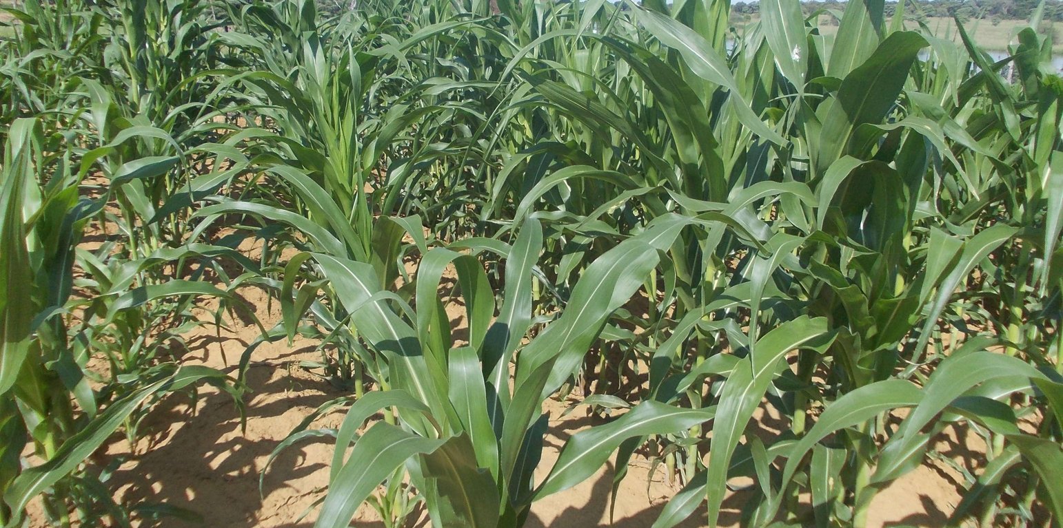
Maize field (Maxon Simfukwe)

Conservation Agriculture in a semi-arid area (นามิเบีย)

Lima nawa (Vambo/Rukwangali)

คำอธิบาย

Conservation agriculture using permanent water-harvesting planting basins, or rip-lines and fertilizer/manure application on low fertility dryland soils.

Farmers in north-eastern Namibia practice shifting/semi-permanent subsistence cropping, concentrating on pearl millet cultivation. Here, conservation agriculture (CA) was promoted to sustain and improve production and to reduce conversion of woodland to crops. CA comprises the three principles of minimum soil disturbance, permanent soil cover, and rotation. CA was tested on small plots with volunteers trained by a local NGO. The technology was characterized here by: (i) Early (pre-rains) preparation of the land with two alternative techniques; either: a) basins with a defined spacing opened by a hand hoe, with composted manure added (biochar has also been tested), or b) rip-lines prepared with oxen in lines and with manure application within the rip lines; (ii) Mulching the soil with crop residues, branches or sunnhemp, specially grown for the purpose; (iii) Protection against grazing of crop and mulch by livestock; (iv) Intercropping with vegetables or legumes. (v) Weeding.

CA has been promoted for four seasons, and now trained farmers are transferring their knowledge to others. The technology was promoted to substantially improve the low yields of traditionally practiced agriculture by improving fertility and soil structure as well as better capturing runoff. It was also aimed at avoiding further expansion of croplands into dry woodlands on low fertility arenosols. Eventually it is hoped that the well-being of local subsistence cropping communities will be improved and outmigration reduced.

Knowledge about CA comes from Zambia, where it has been has been practiced successfully for many years by small-scale farmers. A local NGO was engaged by an international project (www.future-okavango.org) which searched for volunteer farmers in the Kavango area. The first CA planting took place in 2011/12. These pioneer farmers were backstopped regularly and the number of farmers trained increased. The NGO monitored crops with contact farmers. 45 more farmers showed interest and were then trained by the contact farmers. Training and backstopping continued until August 2015.

The natural environment is semi-arid. Rainfall is concentrated from November to March. Mean annual precipitation is 570 mm, and mean air temperature is 26.2°C in the hottest month (October) and 16.2°C in the coldest month (July). The landscape forms part of the extended Kalahari basin in central-southern Africa. Deep and extended sands restrict people to living in areas close to surface water. Villages are located along the Okavango on the elevated river terraces – where they produce crops. Here, sedimentation of fine-grained soils, the accumulation of calcium carbonates in the subsoil and the activity of termites have resulted in soils of medium fertility which could potentially ensure yields of 500 kg/ha of millet, if well managed, and assuming good rainfall. Due to the growing population and restricted land availability, cultivation patterns have changed from shifting to semi-permanent and expanded to the adjacent woodlands on the deep Kalahari sands. Here, rapid degradation of soil fertility has caused further expansion and reduced crop yields to very low levels (ca. 150 kg/ha on average). Livestock graze and browse vegetation on the floodplains and in the woodlands. Due to night-time kraaling of livestock, manure is available as fertilizer: thus sustained cropping can be supported. The importance of the woodlands for ecosystem services including timber and firewood, for thatching grass, medicinal plants and biodiversity means they must be conserved and this acts as a reason to support the search for alternative crop production systems such as CA.
สถานที่

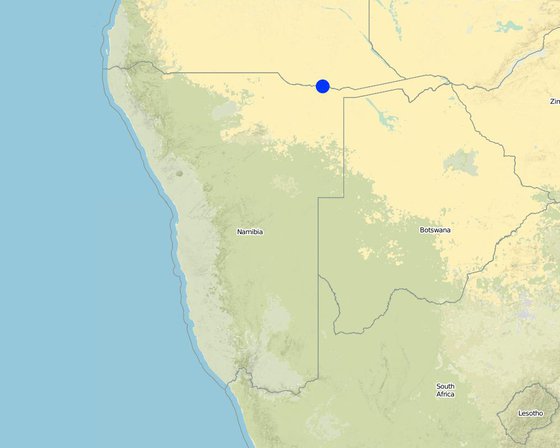
สถานที่: Mashare, Kavango East, นามิเบีย

ตำนวนการวิเคราะห์เทคโนโลยี:

ตำแหน่งทางภูมิศาสตร์ของสถานที่ที่ถูกเลือ
  • 20.16, -17.9

การเผยแพร่ของเทคโนโลยี: กระจายไปอย่างสม่ำเสมอในพื้นที่ (approx. < 0.1 ตร.กม.(10 เฮกตาร์))

In a permanently protected area?:

วันที่ในการดำเนินการ: น้อยกว่า 10 ปี (ไม่นานนี้)

ประเภทของการแนะนำ
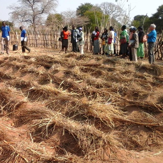
Demostration plot: Basins prepared and mulch distributed (Maxon Simfukwe)

การจำแนกประเภทเทคโนโลยี

จุดประสงค์หลัก
  • ปรับปรุงการผลิตให้ดีขึ้น
  • ลด ป้องกัน ฟื้นฟู การเสื่อมโทรมของที่ดิน
  • อนุรักษ์ระบบนิเวศน์
  • ป้องกันพื้นที่ลุ่มน้ำ/บริเวณท้ายน้ำ โดยร่วมกับเทคโนโลยีอื่นๆ
  • รักษาสภาพหรือปรับปรุงความหลากหลายทางชีวภาพ
  • ลดความเสี่ยงของภัยพิบัติ
  • ปรับตัวเข้ากับการเปลี่ยนแปลงภูมิอากาศของโลก สภาพภูมิอากาศที่รุนแรงและผลกระทบ
  • ชะลอการเปลี่ยนแปลงภูมิอากาศของโลกและผลกระทบ
  • สร้างผลกระทบทางด้านเศรษฐกิจที่เป็นประโยชน์
  • สร้างผลกระทบทางด้านสังคมที่เป็นประโยชน์
การใช้ที่ดิน
Land use mixed within the same land unit: ใช่ - Agro-pastoralism (incl. integrated crop-livestock)

  • พื้นที่ปลูกพืช
    • การปลูกพืชล้มลุกอายุปีเดียว
    จำนวนของฤดูเพาะปลูกต่อปี: 1
  • ทุ่งหญ้าเลี้ยงสัตว์
    • กึ่งโนแมนดิซึ่มหรือแพสโตแรลลิซึ่ม (Semi-nomadism/pastoralism)
การใช้น้ำ
  • จากน้ำฝน
  • น้ำฝนร่วมกับการชลประทาน
  • การชลประทานแบบเต็มรูปแบบ

ความมุ่งหมายที่เกี่ยวข้องกับการเสื่อมโทรมของที่ดิน
  • ป้องกันความเสื่อมโทรมของที่ดิน
  • ลดความเสื่อมโทรมของดิน
  • ฟื้นฟูบำบัดที่ดินที่เสื่อมโทรมลงอย่างมาก
  • ปรับตัวกับสภาพความเสื่อมโทรมของที่ดิน
  • ไม่สามารถใช้ได้
ที่อยู่ของการเสื่อมโทรม
  • การเสื่อมโทรมของดินทางด้านเคมี - Cn (Fertility decline): ความอุดมสมบูรณ์และปริมาณอินทรียวัตถุในดินถูกทำให้ลดลงไป (ไม่ได้เกิดจากสาเหตุการกัดกร่อน)
  • การเสื่อมโทรมของดินทางด้านชีวภาพ - Bc (Reduction of vegetation cover): การลดลงของจำนวนพืชที่ปกคลุมดิน , Bf (Detrimenta leffects of fires): ผลเสียหายจากไฟ, Bl (Loss of soil life): การสูญเสียสิ่งมีชีวิตในดิน
กลุ่ม SLM
  • การจัดการความอุดมสมบรูณ์ของดินแบบผสมผสาน
  • มาตรการปลูกพืชขวางความลาดชัน (cross-slope measure)
  • การเก็บเกี่ยวน้ำ
มาตรการ SLM
  • มาตรการจัดการพืช - A3: การรักษาหน้าดิน
  • มาตรการอนุรักษ์ด้วยการจัดการ - M2: การเปลี่ยนแปลงของการจัดการหรือระดับความเข้มข้น

แบบแปลนทางเทคนิค

ข้อมูลจำเพาะด้านเทคนิค
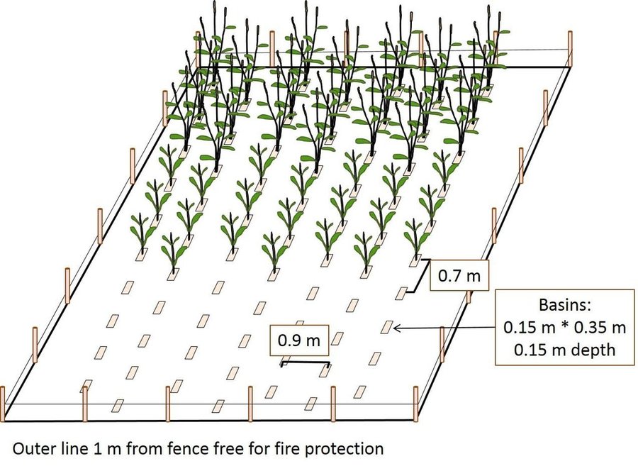
Scheme of CA field with basins
Within the fenced area, basins are dug per hand-hoe in lines with about 15 cm width, 35 cm length and 15 cm depth and in 70 cm distance. To keep the line and position, a rope with knots every 70 cm is used. Each basin is refilled with 2 cans of manure mixed with part of the soil material. Maize or pearl millet - two stages shown on the graph
Location: Mashare. Kavano East/Namibia

Technical knowledge required for field staff / advisors: moderate
Technical knowledge required for land users: low
Main technical functions: increase in nutrient availability (supply, recycling,…)
Secondary technical functions: increase / maintain water stored in soil, increase of biomass (quantity)

Early planting
Remarks: Planting basins prepared in dry season, planting can occur by first rainfalls (earlier than plough-d

Mixed cropping / intercropping
Material/ species: Maize / Millet /Cowpea
Remarks: Cultivated in parallel lines

Mulching
Material/ species: Grasses & crop residues & sunhemp
Remarks: sunhemp cultivated on the CA field and cut to produce mulch

Green manure
Material/ species: branches of fertilizer tree

Manure / compost / residues
Material/ species: Composted manure from cattle post

Rotations / fallows
Material/ species: Maize / Millet /Cowpea
Remarks: Planted in lines and shifted annually

Minimum tillage
Material/ species: Riplines by oxen

Pits
Material/ species: planting basins by hand hoe

Retention/infiltration ditch/pit, sediment/sand trap
Spacing between structures (m): 0.7
Depth of ditches/pits/dams (m): 0.15
Width of ditches/pits/dams (m): 0.15
Length of ditches/pits/dams (m): 0.35

Structural measure: ripline
Spacing between structures (m): 0.7
Depth of ditches/pits/dams (m): 0.25
Width of ditches/pits/dams (m): 0.1

For water harvesting: the ratio between the area where the harvested water is applied and the total area from which water is collected is: 1:8,3
Change of land use practices / intensity level: More specific soil management; crop protection by fencing; earlier seeding
Major change in timing of activities: To a large part, land preparation can be carried out throughout dry season, independent of rainfall level
Author: Maxon Simfukwe

การจัดตั้งและการบำรุงรักษา: กิจกรรม ปัจจัยและค่าใช้จ่าย

การคำนวนต้นทุนและค่าใช้จ่าย
  • ค่าใช้จ่ายถูกคำนวน
  • สกุลเงินที่ใช้คำนวณค่าใช้จ่าย Nam $
  • อัตราแลกเปลี่ยน (ไปเป็นดอลลาร์สหรัฐ) คือ 1 ดอลลาร์สหรัฐ = 15.5 Nam $
  • ค่าจ้างเฉลี่ยในการจ้างแรงงานต่อวันคือ ไม่มีคำตอบ
ปัจจัยที่สำคัญที่สุดที่มีผลต่อค่าใช้จ่าย
CA was designed to require minimal financial investments; theoretically, everything apart from wire for the fences and inorganic fertilizer can be created or gather by the household. This turns CA into a very labour intensive farming practice. The high Dollar values above result from multiplying the (free) family labour invested in farming with the typical hourly wage rate of an external worker
กิจกรรมเพื่อการจัดตั้ง
  1. (ช่วงระยะเวลา/ความถี่: dry season)
ปัจจัยและค่าใช้จ่ายของการจัดตั้ง
ปัจจัยนำเข้า หน่วย ปริมาณ ค่าใช้จ่ายต่อหน่วย (Nam $) ค่าใช้จ่ายทั้งหมดต่อปัจจัยนำเข้า (Nam $) %ของค่าใช้จ่ายที่ก่อให้เกิดขึ้นโดยผู้ใช้ที่ดิน
แรงงาน
labour ha 1.0 1104.0 1104.0 100.0
วัสดุสำหรับก่อสร้าง
Wire for fencing ha 1.0 224.0 224.0 100.0
sticks & poles ha 1.0 1114.0 1114.0 100.0
ค่าใช้จ่ายทั้งหมดของการจัดตั้งเทคโนโลยี 2'442.0
Total costs for establishment of the Technology in USD 157.55
กิจกรรมสำหรับการบำรุงรักษา
  1. Repairing fences and de-bushing of the fields (ช่วงระยะเวลา/ความถี่: (May - July))
  2. Gatering and spreading of mulch cover (ช่วงระยะเวลา/ความถี่: July - Dec)
  3. Cutting sunhemp and applying as additional mulch (ช่วงระยะเวลา/ความถี่: Feb-Mar)
  4. Re-digging the planting basins (ช่วงระยะเวลา/ความถี่: August)
  5. Manure collection, Planting & fertilizer application (ช่วงระยะเวลา/ความถี่: September - December)
  6. Sowing of main crops and sunnhemp and fertilizer application (ช่วงระยะเวลา/ความถี่: November - December)
  7. Intercropping with legumes like groundnuts and cowpeas normally two weeks after germination of cereals. (ช่วงระยะเวลา/ความถี่: None)
  8. Weeding (ช่วงระยะเวลา/ความถี่: None)
  9. Harvesting (ช่วงระยะเวลา/ความถี่: April - May)
ปัจจัยและค่าใช้จ่ายของการบำรุงรักษา
ปัจจัยนำเข้า หน่วย ปริมาณ ค่าใช้จ่ายต่อหน่วย (Nam $) ค่าใช้จ่ายทั้งหมดต่อปัจจัยนำเข้า (Nam $) %ของค่าใช้จ่ายที่ก่อให้เกิดขึ้นโดยผู้ใช้ที่ดิน
แรงงาน
labour ha 1.0 848.0 848.0 100.0
วัสดุด้านพืช
seeds ha 1.0 22.0 22.0 100.0
ปุ๋ยและสารฆ่า/ยับยั้งการเจริญเติบโตของสิ่งมีชีวิต (ไบโอไซด์)
fertilizer ha 1.0 159.0 159.0 100.0
compost/manure ha 1.0 276.0 276.0 100.0
วัสดุสำหรับก่อสร้าง
Wire for fencing ha 1.0 220.0 220.0 100.0
ค่าใช้จ่ายทั้งหมดของการบำรุงรักษาสภาพเทคโนโลยี 1'525.0
Total costs for maintenance of the Technology in USD 98.39

สิ่งแวดล้อมทางธรรมชาติ

ปริมาณน้ำฝนเฉลี่ยรายปี
  • < 250 ม.ม.
  • 251-500 ม.ม.
  • 501-750 ม.ม.
  • 751-1,000 ม.ม.
  • 1,001-1,500 ม.ม.
  • 1,501-2,000 ม.ม.
  • 2,001-3,000 ม.ม.
  • 3,001-4,000 ม.ม.
  • > 4,000 ม.ม.
เขตภูมิอากาศเกษตร
  • ชื้น
  • กึ่งชุ่มชื้น
  • กึ่งแห้งแล้ง
  • แห้งแล้ง
ข้อมูลจำเพาะเรื่องภูมิอากาศ
Thermal climate class: subtropics
ความชัน
  • ราบเรียบ (0-2%)
  • ลาดที่ไม่ชัน (3-5%)
  • ปานกลาง (6-10%)
  • เป็นลูกคลื่น (11-15%)
  • เป็นเนิน (16-30%)
  • ชัน (31-60%)
  • ชันมาก (>60%)
ภูมิลักษณ์
  • ที่ราบสูง/ที่ราบ
  • สันเขา
  • ไหล่เขา
  • ไหล่เนินเขา
  • ตีนเนิน
  • หุบเขา
ความสูง
  • 0-100 เมตร
  • 101-500 เมตร
  • 501-1,000 เมตร
  • 1,001-1,500 เมตร
  • 1,501-2,000 เมตร
  • 2,001-2,500 เมตร
  • 2,501-3,000 เมตร
  • 3,001-4,000 เมตร
  • > 4,000 เมตร
เทคโนโลยีถูกประยุกต์ใช้ใน
  • บริเวณสันเขา (convex situations)
  • บริเวณแอ่งบนที่ราบ (concave situations)
  • ไม่เกี่ยวข้อง
ความลึกของดิน
  • ตื้นมาก (0-20 ซ.ม.)
  • ตื้น (21-50 ซ.ม.)
  • ลึกปานกลาง (51-80 ซ.ม.)
  • ลึก (81-120 ซ.ม.)
  • ลึกมาก (>120 ซ.ม.)
เนื้อดิน (ดินชั้นบน)
  • หยาบ/เบา (ดินทราย)
  • ปานกลาง (ดินร่วน ทรายแป้ง)
  • ละเอียด/หนัก (ดินเหนียว)
เนื้อดิน (> 20 ซม. ต่ำกว่าพื้นผิว)
  • หยาบ/เบา (ดินทราย)
  • ปานกลาง (ดินร่วน ทรายแป้ง)
  • ละเอียด/หนัก (ดินเหนียว)
สารอินทรียวัตถุในดิน
  • สูง (>3%)
  • ปานกลาง (1-3%)
  • ต่ำ (<1%)
น้ำบาดาล
  • ที่ผิวดิน
  • <5 เมตร
  • 5-50 เมตร
  • > 50 เมตร
ระดับน้ำบาดาลที่ผิวดิน
  • เกินพอ
  • ดี
  • ปานกลาง
  • ไม่ดีหรือไม่มีเลย
คุณภาพน้ำ (ยังไม่ได้รับการบำบัด)
  • เป็นน้ำเพื่อการดื่มที่ดี
  • เป็นน้ำเพื่อการดื่มที่ไม่ดี (จำเป็นต้องได้รับการบำบัด)
  • เป็นน้ำใช้เพื่อการเกษตรเท่านั้น (การชลประทาน)
  • ใช้ประโยชน์ไม่ได้
Water quality refers to:
ความเค็มของน้ำเป็นปัญหาหรือไม่?
  • ใช่
  • ไม่ใช่

การเกิดน้ำท่วม
  • ใช่
  • ไม่ใช่
ความหลากหลายทางชนิดพันธุ์
  • สูง
  • ปานกลาง
  • ต่ำ
ความหลากหลายของแหล่งที่อยู่
  • สูง
  • ปานกลาง
  • ต่ำ

ลักษณะเฉพาะของผู้ใช้ที่ดินที่ประยุกต์ใช้เทคโนโลยี

เป้าหมายทางการตลาด
  • เพื่อการยังชีพ (หาเลี้ยงตนเอง)
  • mixed (subsistence/ commercial)
  • ทำการค้า/การตลาด
รายได้จากภายนอกฟาร์ม
  • < 10% ของรายได้ทั้งหมด
  • 10-50% ของรายได้ทั้งหมด
  • > 50% ของรายได้ทั้งหมด
ระดับของความมั่งคั่งโดยเปรียบเทียบ
  • ยากจนมาก
  • จน
  • พอมีพอกิน
  • รวย
  • รวยมาก
ระดับของการใช้เครื่องจักรกล
  • งานที่ใช้แรงกาย
  • การใช้กำลังจากสัตว์
  • การใช้เครื่องจักรหรือเครื่องยนต์
อยู่กับที่หรือเร่ร่อน
  • อยู่กับที่
  • กึ่งเร่ร่อน
  • เร่ร่อน
เป็นรายบุคคลหรือกลุ่ม
  • เป็นรายบุคคล/ครัวเรือน
  • กลุ่ม/ชุมชน
  • สหกรณ์
  • ลูกจ้าง (บริษัท รัฐบาล)
เพศ
  • หญิง
  • ชาย
อายุ
  • เด็ก
  • ผู้เยาว์
  • วัยกลางคน
  • ผู้สูงอายุ
พื้นที่ที่ใช้ต่อครัวเรือน
  • < 0.5 เฮกตาร์
  • 0.5-1 เฮกตาร์
  • 1-2 เฮกตาร์
  • 2-5 เฮกตาร์
  • 5-15 เฮกตาร์
  • 15-50 เฮกตาร์
  • 50-100 เฮกตาร์
  • 100-500 เฮกตาร์
  • 500-1,000 เฮกตาร์
  • 1,000-10,000 เฮกตาร์
  • >10,000 เฮกตาร์
ขนาด
  • ขนาดเล็ก
  • ขนาดกลาง
  • ขนาดใหญ่
กรรมสิทธิ์ในที่ดิน
  • รัฐ
  • บริษัท
  • เป็นแบบชุมชนหรือหมู่บ้าน
  • กลุ่ม
  • รายบุคคล ไม่ได้รับสิทธิครอบครอง
  • รายบุคคล ได้รับสิทธิครอบครอง
สิทธิในการใช้ที่ดิน
  • เข้าถึงได้แบบเปิด (ไม่ได้จัดระเบียบ)
  • เกี่ยวกับชุมชน (ถูกจัดระเบียบ)
  • เช่า
  • รายบุคคล
สิทธิในการใช้น้ำ
  • เข้าถึงได้แบบเปิด (ไม่ได้จัดระเบียบ)
  • เกี่ยวกับชุมชน (ถูกจัดระเบียบ)
  • เช่า
  • รายบุคคล
เข้าถึงการบริการและโครงสร้างพื้นฐาน
สุขภาพ

จน
x
ดี
การศึกษา

จน
x
ดี
ความช่วยเหลือทางด้านเทคนิค

จน
x
ดี
การจ้างงาน (เช่น ภายนอกฟาร์ม)

จน
x
ดี
ตลาด

จน
x
ดี
พลังงาน

จน
x
ดี
ถนนและการขนส่ง

จน
x
ดี
น้ำดื่มและการสุขาภิบาล

จน
x
ดี
บริการด้านการเงิน

จน
x
ดี

ผลกระทบ

ผลกระทบทางด้านเศรษฐกิจและสังคม
การผลิตพืชผล
ลดลง
x
เพิ่มขึ้น

ค่าใช่จ่ายของปัจจัยการผลิตทางการเกษตร
เพิ่มขึ้น
x
ลดลง


not measured but assumed

รายได้จากฟาร์ม
ลดลง
x
เพิ่มขึ้น

ภาระงาน
เพิ่มขึ้น
x
ลดลง


not measured but assumed

ผลกระทบด้านสังคมและวัฒนธรรม
ความมั่นคงด้านอาหาร / พึ่งตนเองได้
ลดลง
x
ปรับปรุงดีขึ้น

สถานการณ์ด้านสุขภาพ
แย่ลง
x
ปรับปรุงดีขึ้น

โอกาสทางวัฒนธรรม (ด้านจิตวิญญาณ ทางศาสนา ด้านสุนทรียภาพ)
ลดลง
x
ปรับปรุงดีขึ้น

โอกาสทางด้านสันทนาการ
ลดลง
x
ปรับปรุงดีขึ้น

การบรรเทาความขัดแย้ง
แย่ลง
x
ปรับปรุงดีขึ้น


Envy and gossip were observed

สถานการณ์ของกลุ่มด้อยโอกาส ทางด้านสังคมและเศรษฐกิจ (เพศ อายุ สถานภาพ ความเป็นกลุ่มทางชาติพันธุ์)
แย่ลง
x
ปรับปรุงดีขึ้น

contribution to human well-being
decreased
x
increased


Improved and stabilized yields help rural families to adapt to modern lifestyles. However, the long-term contribution of CA to the well-being of the local farmers cannot be foreseen. The establishment of family-owned fenced areas for crop production is likely to have an influence on the social structure of the rural communities.

ผลกระทบด้านนิเวศวิทยา
การระเหย
เพิ่มขึ้น
x
ลดลง


not measured but assumed

ความชื้นในดิน
ลดลง
x
เพิ่มขึ้น


not measured but assumed

สิ่งปกคลุมดิน
ลดลง
x
ปรับปรุงดีขึ้น


not measured but assumed

การหมุนเวียนและการเติมของธาตุอาหาร
ลดลง
x
เพิ่มขึ้น


not measured but assumed

อินทรียวัตถุในดิน/ต่ำกว่าดินชั้น C
ลดลง
x
เพิ่มขึ้น


not measured but assumed

ผลกระทบนอกพื้นที่ดำเนินการ

รายได้และค่าใช้จ่าย

ผลประโยชน์ที่ได้รับเปรียบเทียบกับค่าใช้จ่าย
ผลตอบแทนระยะสั้น
ด้านลบอย่างมาก
x
ด้านบวกอย่างมาก

ผลตอบแทนระยะยาว
ด้านลบอย่างมาก
x
ด้านบวกอย่างมาก

ผลประโยชน์ที่ได้รับเปรียบเทียบกับค่าใช้จ่ายในการบำรุงรักษา
ผลตอบแทนระยะสั้น
ด้านลบอย่างมาก
x
ด้านบวกอย่างมาก

ผลตอบแทนระยะยาว
ด้านลบอย่างมาก
x
ด้านบวกอย่างมาก

การเปลี่ยนแปลงของสภาพภูมิอากาศ

สภาพรุนแรงของภูมิอากาศ (ภัยพิบัติ)
ภัยจากฝนแล้ง

ไม่ดี
x
ดีมาก

การน้อมเอาความรู้และการปรับใช้

เปอร์เซ็นต์ของผู้ใช้ที่ดินในพื้นที่ที่นำเทคโนโลยีไปใช้
  • ครั้งเดียวหรือเป็นการทดลอง
  • 1-10%
  • 11-50%
  • > 50%
จากทั้งหมดที่ได้รับเทคโนโลยีเข้ามามีจำนวนเท่าใดที่ทำแบบทันที โดยไม่ได้รับการจูงใจด้านวัสดุหรือการเงินใดๆ?
  • 0-10%
  • 11-50%
  • 51-90%
  • 91-100%
เทคโนโลยีได้รับการปรับเปลี่ยนเร็วๆ นี้เพื่อให้ปรับตัวเข้ากับสภาพที่กำลังเปลี่ยนแปลงหรือไม่?
  • ใช่
  • ไม่ใช่
สภาพที่กำลังเปลี่ยนแปลงอันไหน?
  • การเปลี่ยนแปลงแบบค่อยเป็นค่อยไปและสภาพรุนแรงของภูมิอากาศ
  • การเปลี่ยนแปลงของตลาด
  • การมีแรงงานไว้ให้ใช้ (เนื่องจากการอพยพย้ายถิ่นฐาน)

บทสรุปหรือบทเรียนที่ได้รับ

จุดแข็ง: มุมมองของผู้ใช้ที่ดิน
  • Saves labour over time
  • Can use less land compared to conventional system for the same harvest/yield
จุดแข็ง: ทัศนคติของผู้รวบรวมหรือวิทยากรคนอื่นๆ
  • A strength of the system is the timely land preparation
  • The advantage of permanent planting stations results from the higher availability of nutrients to crop roots.
  • The moisture retention within the rooting space is improved by the surface structure and the increase in soil organic matter
  • The rotations of crop rotations is encouraged
  • All inputs can be used precicely, there is less wastage of inputs
จุดด้อย/ข้อเสีย/ความเสี่ยง: มุมมองของผู้ใช้ที่ดินแก้ไขปัญหาได้อย่างไร
  • The weed management is labour intensive and the impact of pests might be a future challange. The application of more mulch and the weeding regularly in the first part of the season is supposed to reduce weeds.
จุดด้อย/ข้อเสีย/ความเสี่ยง: ทัศนคติของผู้รวบรวมหรือวิทยากรคนอื่นๆแก้ไขปัญหาได้อย่างไร
  • To start with this technology is labour intensive at the beginning. In this moment, the hard pan caused by years of ploughing has to be loosened. Because the basins/riplines are permanently maintained in CA, the preceding land preparations become easier. Also since land preparation starts before on-set of rains, one can spread labour by starting just after harvesting crop
  • There is a general problem of constructing fences around fields in communal lands, as state authorities declare this land as being owned by the state. By agreeing with the local leadership to allow those doing CA to fence off their fields for proper keeping of residues and basins/riplines that might be prone to free livestock grazing after crop harvests.

การอ้างอิง

ผู้รวบรวม
  • Alexander Groengroeft
Editors
ผู้ตรวจสอบ
  • Deborah Niggli
  • David Streiff
  • Alexandra Gavilano
วันที่จัดทำเอกสาร: 17 มีนาคม 2016
การอัพเดทล่าสุด: 31 พฤษภาคม 2019
วิทยากร
คำอธิบายฉบับเต็มในฐานข้อมูล WOCAT
ข้อมูล SLM ที่ถูกอ้างอิง
การจัดทำเอกสารถูกทำโดย
องค์กร โครงการ
การอ้งอิงหลัก
  • Groengroeft, A., et al. (2013) A method for yield assessment on rainfeld dryland agricultural fields.: Biodiversity & Ecology 5:279 - 286
  • Kowalski, B. et al. (2013) Mashare - The People.: Biodiversity & Ecology 5:121-128
  • Pröpper, M. et al. (2010) Causes and perspectives of land-cover change through expanding cultivation in Kavango.: Biodiversity in southern Africa. Volume 3: Implications for landuse and management, eds. M. T. Hoffman, U. Schmiedel and N. Jürgens. Göttingen & Windhoek: Klaus Hess Publishers.
  • Pröpper, M. et al. (2015) The Future Okavango – Findings, Scenarios and Recommendations for Action.: Research Project Final Synthesis Report 2010-2015, 190. Windhoek: University of Hamburg
This work is licensed under Creative Commons Attribution-NonCommercial-ShareaAlike 4.0 International