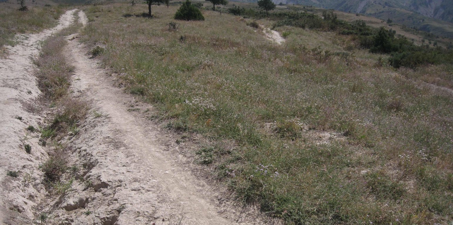
Eroded path through the pastureland (Malgorzata Conder)

Pasture management of a communal grazing land (ทาจิกิสถาน)

คำอธิบาย

Pasture management of a communal land through daily rotation

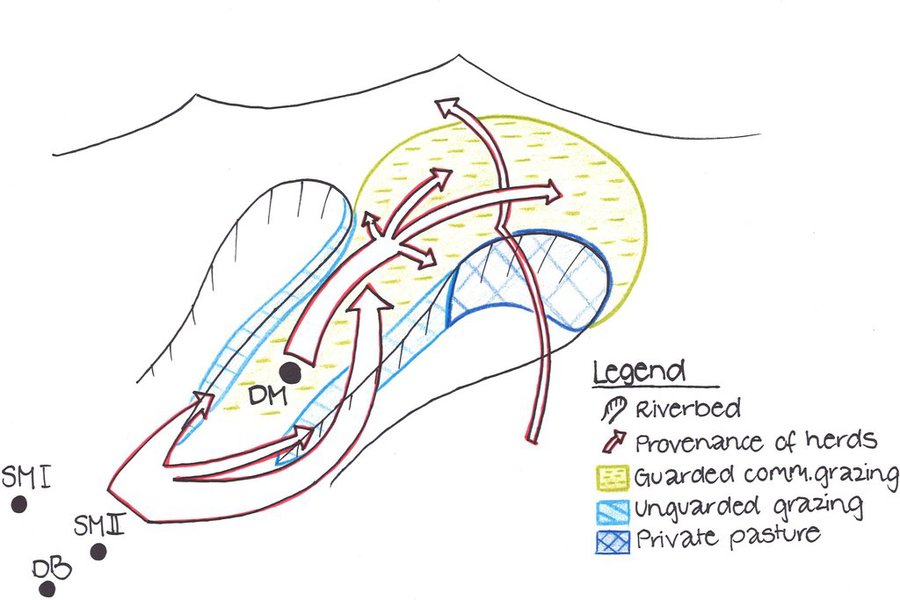
The total area of the pasture accounts for 300 – 500 ha. The pasture is property of the Doshmand village but it includes also some private properties, mainly potato and wheat crops. After the harvest, livestock is also grazing on these crops. Eighteen households are currently using the pasture with a total of 150 cows and 500 small animals. Additionally, three groups of herds from other villages graze irregularly on this pasture mainly on the lateral parts as it is less guarded by the villagers. The interviewee estimates that over 1000 cows, goats and sheep are coming from other villages. Other herds cross this pasture when migrating to or coming back from the summer pasture in spring and autumn, respectively. Nevertheless Doshmand residents claim that this intrusive grazing is accepted as “every animal has to be fed”. This shows the need of a pasture management not only on village but also on watershed level.
During Soviet time the inhabitants of Doshmand were forced to migrate to the valley. In 2003, the resettlement of the ancient location started with two families. Simultaneously, the pasture management was established and joined by each family who resettled. The controlled area is divided in 4 subparts. The herd switches daily within them. Every household looks after the herd for a day, which results in a rotational cycle of 18 days. There are no fixed and regular meetings for pasture management within the village pasture. However, two subsequent herders communicate to know where the herd has been grazing and where to graze the next time.

Purpose of the Technology: Purpose of the rotational grazing is to graze on one subpart, while the three other areas are resting. This reduces the impact of grazed and trampled areas per subpart and allows the growth and recovery of the vegetation in the other parts.
The task of herding is shared among the families. The rotational grazing is organized orally and freely, why it’s not sure if that approach is strictly binding. Discussions about pasture management rise only in case of need.

Establishment / maintenance activities and inputs: Doshmand village got the pasture in a good condition at the time of establishment. Vegetation cover was high. The only investment consisted in building a water point for the livestock. A further investment was to buy a water pipe and dig out a channel for the pipe to conduct the water from the water point to the village. Money was collected by the families and many villagers were involved in digging the channel.
No further input was and is required except coordination between the herders.

Natural / human environment: The pasture of Doshmand village is located in the middle and upper zone of the watershed. Thanks to the distance to other settlements, the pasture is less affected by overgrazing than other communal pastures in the watershed. Nevertheless, the pasture is heterogeneously grazed, with some areas which are difficult to access even for livestock and hence abundant vegetation. Other areas, especially those situated next to the village show a more bare vegetation cover.
สถานที่

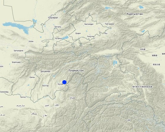
สถานที่: Muminabad, Khatlon, Tajikistan, ทาจิกิสถาน

ตำนวนการวิเคราะห์เทคโนโลยี:

ตำแหน่งทางภูมิศาสตร์ของสถานที่ที่ถูกเลือ
  • 70.04219, 38.01485

การเผยแพร่ของเทคโนโลยี: กระจายไปอย่างสม่ำเสมอในพื้นที่ (approx. 1-10 ตร.กม.)

In a permanently protected area?:

วันที่ในการดำเนินการ: 10-50 ปี

ประเภทของการแนะนำ
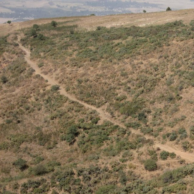
Heterogenous vegetation cover within the watershed (Malgorzata Conder)

การจำแนกประเภทเทคโนโลยี

จุดประสงค์หลัก
  • ปรับปรุงการผลิตให้ดีขึ้น
  • ลด ป้องกัน ฟื้นฟู การเสื่อมโทรมของที่ดิน
  • อนุรักษ์ระบบนิเวศน์
  • ป้องกันพื้นที่ลุ่มน้ำ/บริเวณท้ายน้ำ โดยร่วมกับเทคโนโลยีอื่นๆ
  • รักษาสภาพหรือปรับปรุงความหลากหลายทางชีวภาพ
  • ลดความเสี่ยงของภัยพิบัติ
  • ปรับตัวเข้ากับการเปลี่ยนแปลงภูมิอากาศของโลก สภาพภูมิอากาศที่รุนแรงและผลกระทบ
  • ชะลอการเปลี่ยนแปลงภูมิอากาศของโลกและผลกระทบ
  • สร้างผลกระทบทางด้านเศรษฐกิจที่เป็นประโยชน์
  • สร้างผลกระทบทางด้านสังคมที่เป็นประโยชน์
การใช้ที่ดิน

  • พื้นที่ปลูกพืช
    • การปลูกพืชล้มลุกอายุปีเดียว: cereals - wheat (spring), cereals - wheat (winter), root/tuber crops - potatoes
    จำนวนของฤดูเพาะปลูกต่อปี: 1
  • ทุ่งหญ้าเลี้ยงสัตว์
    • กึ่งโนแมนดิซึ่มหรือแพสโตแรลลิซึ่ม (Semi-nomadism/pastoralism)
    • rotational grazing

การใช้น้ำ
  • จากน้ำฝน
  • น้ำฝนร่วมกับการชลประทาน
  • การชลประทานแบบเต็มรูปแบบ

ความมุ่งหมายที่เกี่ยวข้องกับการเสื่อมโทรมของที่ดิน
  • ป้องกันความเสื่อมโทรมของที่ดิน
  • ลดความเสื่อมโทรมของดิน
  • ฟื้นฟูบำบัดที่ดินที่เสื่อมโทรมลงอย่างมาก
  • ปรับตัวกับสภาพความเสื่อมโทรมของที่ดิน
  • ไม่สามารถใช้ได้
ที่อยู่ของการเสื่อมโทรม
  • การกัดกร่อนของดินโดยน้ำ - Wo (Offsite degradation): ผลกระทบนอกพื้นที่
  • การเสื่อมโทรมของดินทางด้านเคมี - Cn (Fertility decline): ความอุดมสมบูรณ์และปริมาณอินทรียวัตถุในดินถูกทำให้ลดลงไป (ไม่ได้เกิดจากสาเหตุการกัดกร่อน)
  • การเสื่อมโทรมของดินทางด้านกายภาพ - Pc (Compaction): การอัดแน่น
  • การเสื่อมโทรมของดินทางด้านชีวภาพ - Bc (Reduction of vegetation cover): การลดลงของจำนวนพืชที่ปกคลุมดิน , Bs (Quality and species composition): องค์ประกอบหรือความหลากหลายทางคุณภาพและชนิดพันธุ์ลดลง
กลุ่ม SLM
  • การจัดการปศุสัตว์และทุ่งหญ้าเลี้ยงสัตว์
มาตรการ SLM
  • มาตรการอนุรักษ์ด้วยการจัดการ - M2: การเปลี่ยนแปลงของการจัดการหรือระดับความเข้มข้น

แบบแปลนทางเทคนิค

ข้อมูลจำเพาะด้านเทคนิค
Livestock from Doshmand village (DM) is grazing in the four subparts of the communal pasture. Livestock from other villages, located in the valley Sarmadoni I (SMI) and II (SMII) and Dehibaland (DB), can invade the guarded and unguarded communal pasture of Doschmand. In spring and autumn also other livestock crosses Doshmand's pasture when migrating to or leaving the summer pasture.

Location: Chukurak watershed. Muminabad, Khatlon

Technical knowledge required for land users: low

Main technical functions: improvement of ground cover, increase of infiltration

Secondary technical functions: improvement of topsoil structure (compaction), stabilisation of soil (eg by tree roots against land slides), increase in organic matter

Change of land use practices / intensity level: Rotational grazing at village level
Author: Malgorzata Conder

การจัดตั้งและการบำรุงรักษา: กิจกรรม ปัจจัยและค่าใช้จ่าย

การคำนวนต้นทุนและค่าใช้จ่าย
  • ค่าใช้จ่ายถูกคำนวน
  • สกุลเงินที่ใช้คำนวณค่าใช้จ่าย USD
  • อัตราแลกเปลี่ยน (ไปเป็นดอลลาร์สหรัฐ) คือ 1 ดอลลาร์สหรัฐ = ไม่มีคำตอบ
  • ค่าจ้างเฉลี่ยในการจ้างแรงงานต่อวันคือ 12.40
ปัจจัยที่สำคัญที่สุดที่มีผลต่อค่าใช้จ่าย
There are no costly factors, the most important input is a good planning, coordination and consistent execution of the rotational grazing system. The installation of a waterpoint would be needed but it is a very costly installation.
กิจกรรมเพื่อการจัดตั้ง
  1. Coordination with villagers and herders (ช่วงระยะเวลา/ความถี่: Reestablishment of village)
ปัจจัยและค่าใช้จ่ายของการจัดตั้ง
ปัจจัยนำเข้า หน่วย ปริมาณ ค่าใช้จ่ายต่อหน่วย (USD) ค่าใช้จ่ายทั้งหมดต่อปัจจัยนำเข้า (USD) %ของค่าใช้จ่ายที่ก่อให้เกิดขึ้นโดยผู้ใช้ที่ดิน
แรงงาน
Coordination with villagers and herders - 1.0
กิจกรรมสำหรับการบำรุงรักษา
  1. Consultation with village herders (ช่วงระยะเวลา/ความถี่: If needed)
ปัจจัยและค่าใช้จ่ายของการบำรุงรักษา
ปัจจัยนำเข้า หน่วย ปริมาณ ค่าใช้จ่ายต่อหน่วย (USD) ค่าใช้จ่ายทั้งหมดต่อปัจจัยนำเข้า (USD) %ของค่าใช้จ่ายที่ก่อให้เกิดขึ้นโดยผู้ใช้ที่ดิน
แรงงาน
Consultation with village herders - 1.0

สิ่งแวดล้อมทางธรรมชาติ

ปริมาณน้ำฝนเฉลี่ยรายปี
  • < 250 ม.ม.
  • 251-500 ม.ม.
  • 501-750 ม.ม.
  • 751-1,000 ม.ม.
  • 1,001-1,500 ม.ม.
  • 1,501-2,000 ม.ม.
  • 2,001-3,000 ม.ม.
  • 3,001-4,000 ม.ม.
  • > 4,000 ม.ม.
เขตภูมิอากาศเกษตร
  • ชื้น
  • กึ่งชุ่มชื้น
  • กึ่งแห้งแล้ง
  • แห้งแล้ง
ข้อมูลจำเพาะเรื่องภูมิอากาศ
Annual rainfall (1,001-1,500 mm): Totally 800mm: 700mm in winter-spring, July-Sept dry season (At 1200mm asl, weather station Muminabad)

Annual rainfall (1,501-2,000 mm): Precipitation increases 60mm per 100m of altitude in average. Here up to 1600mm.
Thermal climate class: temperate

LPG from April until September
ความชัน
  • ราบเรียบ (0-2%)
  • ลาดที่ไม่ชัน (3-5%)
  • ปานกลาง (6-10%)
  • เป็นลูกคลื่น (11-15%)
  • เป็นเนิน (16-30%)
  • ชัน (31-60%)
  • ชันมาก (>60%)
ภูมิลักษณ์
  • ที่ราบสูง/ที่ราบ
  • สันเขา
  • ไหล่เขา
  • ไหล่เนินเขา
  • ตีนเนิน
  • หุบเขา
ความสูง
  • 0-100 เมตร
  • 101-500 เมตร
  • 501-1,000 เมตร
  • 1,001-1,500 เมตร
  • 1,501-2,000 เมตร
  • 2,001-2,500 เมตร
  • 2,501-3,000 เมตร
  • 3,001-4,000 เมตร
  • > 4,000 เมตร
เทคโนโลยีถูกประยุกต์ใช้ใน
  • บริเวณสันเขา (convex situations)
  • บริเวณแอ่งบนที่ราบ (concave situations)
  • ไม่เกี่ยวข้อง
ความลึกของดิน
  • ตื้นมาก (0-20 ซ.ม.)
  • ตื้น (21-50 ซ.ม.)
  • ลึกปานกลาง (51-80 ซ.ม.)
  • ลึก (81-120 ซ.ม.)
  • ลึกมาก (>120 ซ.ม.)
เนื้อดิน (ดินชั้นบน)
  • หยาบ/เบา (ดินทราย)
  • ปานกลาง (ดินร่วน ทรายแป้ง)
  • ละเอียด/หนัก (ดินเหนียว)
เนื้อดิน (> 20 ซม. ต่ำกว่าพื้นผิว)
  • หยาบ/เบา (ดินทราย)
  • ปานกลาง (ดินร่วน ทรายแป้ง)
  • ละเอียด/หนัก (ดินเหนียว)
สารอินทรียวัตถุในดิน
  • สูง (>3%)
  • ปานกลาง (1-3%)
  • ต่ำ (<1%)
น้ำบาดาล
  • ที่ผิวดิน
  • <5 เมตร
  • 5-50 เมตร
  • > 50 เมตร
ระดับน้ำบาดาลที่ผิวดิน
  • เกินพอ
  • ดี
  • ปานกลาง
  • ไม่ดีหรือไม่มีเลย
คุณภาพน้ำ (ยังไม่ได้รับการบำบัด)
  • เป็นน้ำเพื่อการดื่มที่ดี
  • เป็นน้ำเพื่อการดื่มที่ไม่ดี (จำเป็นต้องได้รับการบำบัด)
  • เป็นน้ำใช้เพื่อการเกษตรเท่านั้น (การชลประทาน)
  • ใช้ประโยชน์ไม่ได้
Water quality refers to:
ความเค็มของน้ำเป็นปัญหาหรือไม่?
  • ใช่
  • ไม่ใช่

การเกิดน้ำท่วม
  • ใช่
  • ไม่ใช่
ความหลากหลายทางชนิดพันธุ์
  • สูง
  • ปานกลาง
  • ต่ำ
ความหลากหลายของแหล่งที่อยู่
  • สูง
  • ปานกลาง
  • ต่ำ

ลักษณะเฉพาะของผู้ใช้ที่ดินที่ประยุกต์ใช้เทคโนโลยี

เป้าหมายทางการตลาด
  • เพื่อการยังชีพ (หาเลี้ยงตนเอง)
  • mixed (subsistence/ commercial)
  • ทำการค้า/การตลาด
รายได้จากภายนอกฟาร์ม
  • < 10% ของรายได้ทั้งหมด
  • 10-50% ของรายได้ทั้งหมด
  • > 50% ของรายได้ทั้งหมด
ระดับของความมั่งคั่งโดยเปรียบเทียบ
  • ยากจนมาก
  • จน
  • พอมีพอกิน
  • รวย
  • รวยมาก
ระดับของการใช้เครื่องจักรกล
  • งานที่ใช้แรงกาย
  • การใช้กำลังจากสัตว์
  • การใช้เครื่องจักรหรือเครื่องยนต์
อยู่กับที่หรือเร่ร่อน
  • อยู่กับที่
  • กึ่งเร่ร่อน
  • เร่ร่อน
เป็นรายบุคคลหรือกลุ่ม
  • เป็นรายบุคคล/ครัวเรือน
  • กลุ่ม/ชุมชน
  • สหกรณ์
  • ลูกจ้าง (บริษัท รัฐบาล)
เพศ
  • หญิง
  • ชาย
อายุ
  • เด็ก
  • ผู้เยาว์
  • วัยกลางคน
  • ผู้สูงอายุ
พื้นที่ที่ใช้ต่อครัวเรือน
  • < 0.5 เฮกตาร์
  • 0.5-1 เฮกตาร์
  • 1-2 เฮกตาร์
  • 2-5 เฮกตาร์
  • 5-15 เฮกตาร์
  • 15-50 เฮกตาร์
  • 50-100 เฮกตาร์
  • 100-500 เฮกตาร์
  • 500-1,000 เฮกตาร์
  • 1,000-10,000 เฮกตาร์
  • >10,000 เฮกตาร์
ขนาด
  • ขนาดเล็ก
  • ขนาดกลาง
  • ขนาดใหญ่
กรรมสิทธิ์ในที่ดิน
  • รัฐ
  • บริษัท
  • เป็นแบบชุมชนหรือหมู่บ้าน
  • กลุ่ม
  • รายบุคคล ไม่ได้รับสิทธิครอบครอง
  • รายบุคคล ได้รับสิทธิครอบครอง
สิทธิในการใช้ที่ดิน
  • เข้าถึงได้แบบเปิด (ไม่ได้จัดระเบียบ)
  • เกี่ยวกับชุมชน (ถูกจัดระเบียบ)
  • เช่า
  • รายบุคคล
สิทธิในการใช้น้ำ
  • เข้าถึงได้แบบเปิด (ไม่ได้จัดระเบียบ)
  • เกี่ยวกับชุมชน (ถูกจัดระเบียบ)
  • เช่า
  • รายบุคคล
เข้าถึงการบริการและโครงสร้างพื้นฐาน
สุขภาพ

จน
ดี
การศึกษา

จน
ดี
ความช่วยเหลือทางด้านเทคนิค

จน
ดี
การจ้างงาน (เช่น ภายนอกฟาร์ม)

จน
ดี
ตลาด

จน
ดี
พลังงาน

จน
ดี
ถนนและการขนส่ง

จน
ดี
น้ำดื่มและการสุขาภิบาล

จน
ดี
บริการด้านการเงิน

จน
ดี

ผลกระทบ

ผลกระทบทางด้านเศรษฐกิจและสังคม
การผลิตพืชที่ใช้เลี้ยงปศุสัตว์
ลดลง
เพิ่มขึ้น

การผลิตสัตว์
ลดลง
เพิ่มขึ้น


Not the whole pastureland can be grazed at once

การมีน้ำไว้ให้ปศุสัตว์
ลดลง
เพิ่มขึ้น

คุณภาพน้ำสำหรับปศุสัตว์
ลดลง
เพิ่มขึ้น

ผลกระทบด้านสังคมและวัฒนธรรม
ความมั่นคงด้านอาหาร / พึ่งตนเองได้
ลดลง
ปรับปรุงดีขึ้น

สถาบันของชุมชน
อ่อนแอลง
เสริมให้แข็งแรง

Livelihoods and human well-being
reduced
improved


Strenghtening of the community sense and awareness through increased coordination for rotational grazing between villagers. Higher fodder availability leads to healthier livestock.

ผลกระทบด้านนิเวศวิทยา
น้ำไหลบ่าที่ผิวดิน
เพิ่มขึ้น
ลดลง

การระเหย
เพิ่มขึ้น
ลดลง

ความชื้นในดิน
ลดลง
เพิ่มขึ้น

การเกิดแผ่นแข็งที่ผิวดิน /การเกิดชั้นดาน
เพิ่มขึ้น
ลดลง

การอัดแน่นของดิน
เพิ่มขึ้น
ลดลง

มวลชีวภาพ/เหนือดินชั้น C
ลดลง
เพิ่มขึ้น

ความเสี่ยงจากไฟ
เพิ่มขึ้น
ลดลง

Hazards towards adverse events
improved
reduced

ผลกระทบนอกพื้นที่ดำเนินการ
การทับถมของดินตะกอนพื้นที่ท้ายน้ำ
เพิ่มขึ้น
ลดลง

ความสามารถต้านทานการเปลี่ยนแปลง / ความสามารถในการคัดกรอง (โดยดิน พืช พื้นที่ชุ่มน้ำ)
ลดลง
ปรับปรุงดีขึ้น

ความเสียหายต่อโครงสร้างพื้นฐานของรัฐหรือของเอกชน
เพิ่มขึ้น
ลดลง

รายได้และค่าใช้จ่าย

ผลประโยชน์ที่ได้รับเปรียบเทียบกับค่าใช้จ่าย
ผลตอบแทนระยะสั้น
ด้านลบอย่างมาก
ด้านบวกอย่างมาก

ผลตอบแทนระยะยาว
ด้านลบอย่างมาก
ด้านบวกอย่างมาก

ผลประโยชน์ที่ได้รับเปรียบเทียบกับค่าใช้จ่ายในการบำรุงรักษา
ผลตอบแทนระยะสั้น
ด้านลบอย่างมาก
ด้านบวกอย่างมาก

ผลตอบแทนระยะยาว
ด้านลบอย่างมาก
ด้านบวกอย่างมาก

การเปลี่ยนแปลงของสภาพภูมิอากาศ

การเปลี่ยนแปลงสภาพภูมิอากาศที่ค่อยเป็นค่อยไป
อุณหภูมิประจำปี เพิ่มขึ้น

ไม่ดี
ดีมาก
สภาพรุนแรงของภูมิอากาศ (ภัยพิบัติ)
พายุฝนประจำท้องถิ่น

ไม่ดี
ดีมาก
พายุลมประจำท้องถิ่น

ไม่ดี
ดีมาก
ภัยจากฝนแล้ง

ไม่ดี
ดีมาก
น้ำท่วมตามปกติ (แม่น้ำ)

ไม่ดี
ดีมาก
ผลลัพธ์ตามมาที่เกี่ยวข้องกับภูมิอากาศอื่น ๆ
ช่วงการปลูกพืชที่ลดลงมา

ไม่ดี
ดีมาก
คำตอบ: ไม่ทราบ

การน้อมเอาความรู้และการปรับใช้

เปอร์เซ็นต์ของผู้ใช้ที่ดินในพื้นที่ที่นำเทคโนโลยีไปใช้
  • ครั้งเดียวหรือเป็นการทดลอง
  • 1-10%
  • 11-50%
  • > 50%
จากทั้งหมดที่ได้รับเทคโนโลยีเข้ามามีจำนวนเท่าใดที่ทำแบบทันที โดยไม่ได้รับการจูงใจด้านวัสดุหรือการเงินใดๆ?
  • 0-10%
  • 11-50%
  • 51-90%
  • 91-100%
จำนวนหลังคาเรือนหรือขนาดพื้นที่รวมทั้งหมด
NA
เทคโนโลยีได้รับการปรับเปลี่ยนเร็วๆ นี้เพื่อให้ปรับตัวเข้ากับสภาพที่กำลังเปลี่ยนแปลงหรือไม่?
  • ใช่
  • ไม่ใช่
สภาพที่กำลังเปลี่ยนแปลงอันไหน?
  • การเปลี่ยนแปลงแบบค่อยเป็นค่อยไปและสภาพรุนแรงของภูมิอากาศ
  • การเปลี่ยนแปลงของตลาด
  • การมีแรงงานไว้ให้ใช้ (เนื่องจากการอพยพย้ายถิ่นฐาน)

บทสรุปหรือบทเรียนที่ได้รับ

จุดแข็ง: มุมมองของผู้ใช้ที่ดิน
  • No big input, coordination between farmers exists anyway
จุดแข็ง: ทัศนคติของผู้รวบรวมหรือวิทยากรคนอื่นๆ
  • In a rotational grazing system at village level every family is responsible for the sustainability of the pasture

    How can they be sustained / enhanced? Give more responsability and co-determination to individuals
  • High establishment potential as rotational grazing do not demand any costs, except coordination and organization on village level

    How can they be sustained / enhanced? Disseminate the idea of rotational grazing also on watershed level
  • Ecologic benefits as high vegetation cover, less erosion etc. can be achieved without monetary investment

    How can they be sustained / enhanced? Spread knowledge of long-term effects by rotational grazing
  • Being a pasture of a big area extent in the uphills, the good quality of the pasture plays an important role for all the settlements and cultivations downstream

    How can they be sustained / enhanced? Raise the awareness about the upstream-downstream interrelation in the watersheds
จุดด้อย/ข้อเสีย/ความเสี่ยง: มุมมองของผู้ใช้ที่ดินแก้ไขปัญหาได้อย่างไร
จุดด้อย/ข้อเสีย/ความเสี่ยง: ทัศนคติของผู้รวบรวมหรือวิทยากรคนอื่นๆแก้ไขปัญหาได้อย่างไร
  • In reality, rotational grazing is not executed strictly enough Stricter separation of the subparts needed
  • Herds from other villages graze in the same pasture Strenghten coordination of grazing between and within villages
  • Some flanks show high vegetation because they are not accessible for livestock and not because of the rotational grazing

การอ้างอิง

ผู้รวบรวม
  • Malgorzata Conder
Editors
ผู้ตรวจสอบ
  • David Streiff
  • Alexandra Gavilano
วันที่จัดทำเอกสาร: 15 มกราคม 2013
การอัพเดทล่าสุด: 6 สิงหาคม 2019
วิทยากร
คำอธิบายฉบับเต็มในฐานข้อมูล WOCAT
ข้อมูล SLM ที่ถูกอ้างอิง
การจัดทำเอกสารถูกทำโดย
องค์กร โครงการ
This work is licensed under Creative Commons Attribution-NonCommercial-ShareaAlike 4.0 International