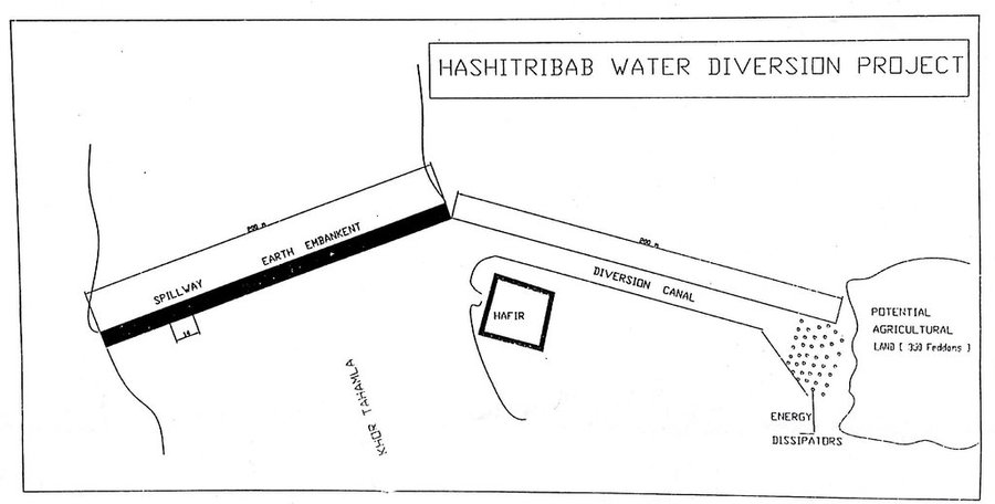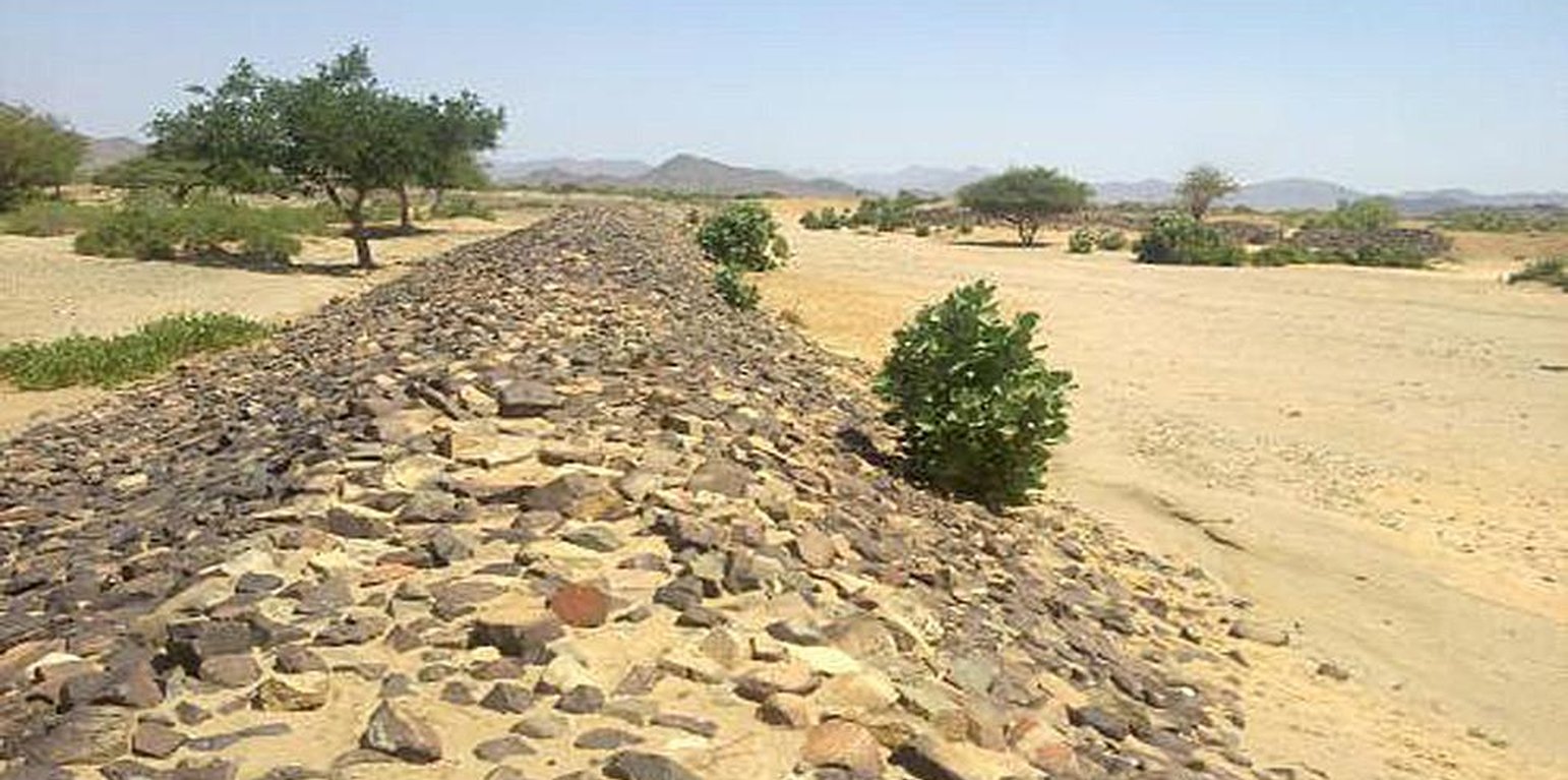
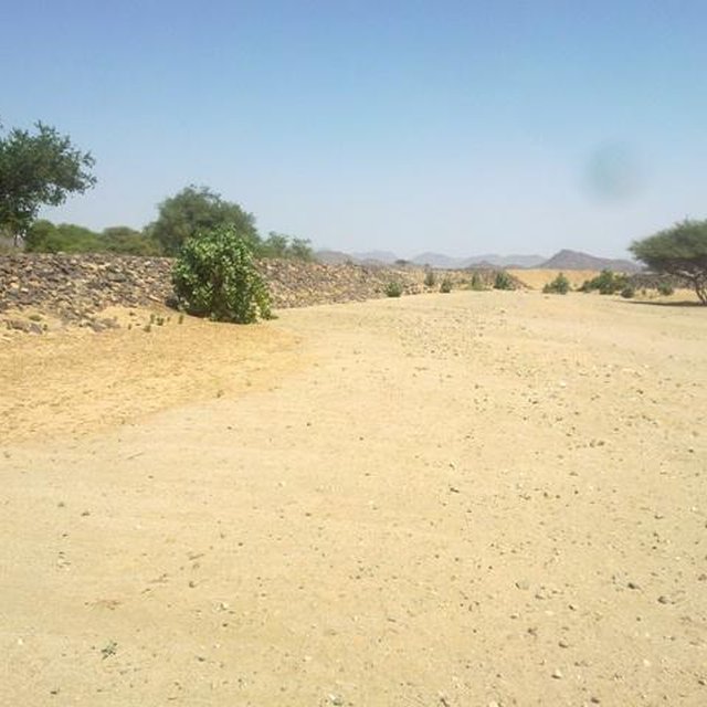
Diversion Dam upstream (Abdalla Osman Eisa (Soil Conservation and Land Use Admin. Port Sudan.))

Water Spreading (typical example from Hashatribab) (ซูดาน)

Sidud (Local Arabic) - Tarrit (Beja dialect) for earth dams

คำอธิบาย

Water Spreading (or Spate Irrigation system) conducted through the construction of earth dam structures at the khor cross section.

Water Spreading (or Spate Irrigation) can be done through the construction of an angled bank or weir – with a spillway in case of excess flow – to divert a “khor” (ephemeral stream) and spread it (using spaced contour bunds) for crop production.

Water Spreading from khors or wadis where channelized runoff/ floodwater is diverted onto plains which are then cultivated on residual moisture. An example of a scheme which was constructed in 1999 is located at Hashitribab, some 7 km from Sinkat on the road towards Kassala. This scheme, comprising a stone-pitched earth diversion barrier across a khor (an ephemeral water course), is documented by using among others the WOCAT Questionnaire and WOCAT’s QA. While the diversion is still intact and provides water to the fields about one kilometre downstream (there were young sorghum plants growing at the time of the visit in November 2011) maintenance will be needed.
There was only a very small input of voluntary labour in its original construction (comprising a contribution in terms of stone pitching).

Construction by the Government, using machinery, with little local contribution might explain why voluntary maintenance of the structures has been negligible. Water spreading schemes have gradually expanded in number over the last 20 years in Red Sea State (according to Sayed Dabloub’s personal comment). Currently it was confirmed that there are new sites under planning and construction.

The purposes of diversion dam construction was to divert the main water course to take its way in the crop growing area replacing the old one and being controlled by small diversion dams (terraces to spread water for even water distribution through the original land. These terraces remarkably reduce gully formation.
Most important purpose is to provide water to growing crops in an area which is too dry for rain fed production and where no source for irrigation is available. It secures moisture during the growing season, by allowing more water to penetrate soil and to preserve moisture for a longer period at plant root zone.
The decrease of flood water velocity leads to silt accumulation and other debris materials which increase soil capability in providing moisture, nutrients and maintain soil structure and conservation.

For the earthen/stone-pitched diversion structure with spillway and small haffir alongside machines have been used (mainly loaders provided by the government) which excavated and built the bund. In addition local communities were involved in some aspects of the establishment (mainly stone pitching) supported/subsidized with incentives. The structure/scheme at Hashitribab (close to Sinkat) was built in 1999 (and no maintenance has been done since that time). It helps in watering about 500 feddan (c. 200 hectares) of agricultural area where water is spread by the use of small contour bunds: these were also constructed using subsidies and machines.
Terraces are usually used to control water spreading along the cropped area. Those terraces usually receive the water at low speed velocity. For that reason they are very small in size and volume. Usually they are located in very gentle and uniformed areas. The terraces can be constructed by simple hand tool and tractors accessories. But the prolonged drought makes the maintenance difficult as the dry soil is more susceptible to wind erosion and sand accumulation on both sides of the dam and the bottom of the bund is one of several desertification phenomenon in the region. But the wind-blown sand is one of the most serious one especially in the dry lands of the Red Sea State. Contour survey for land leveling slope identification and location is an important step before implementation.

The study site is located in the arid region of Red Sea State where steep hills from north-south inland mountains are interrupted by arid plains. The population density is low and the population depends on both cropping and livestock with high incidence of poverty. For this reason there should be a clear plan for construction and community extension approach to care about the maintenance of the technology. About 120 families live in Hashitribab area. All the year round they secure their provision by storing food crops in particular sorghum.
สถานที่

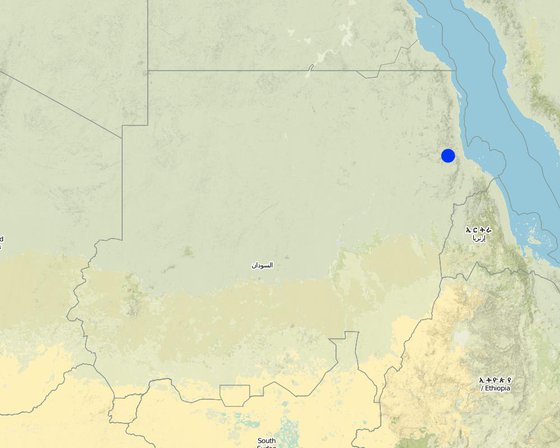
สถานที่: Sinkat Locality, Red Sea, ซูดาน

ตำนวนการวิเคราะห์เทคโนโลยี:

ตำแหน่งทางภูมิศาสตร์ของสถานที่ที่ถูกเลือ
  • 36.7805, 18.8765

การเผยแพร่ของเทคโนโลยี: กระจายไปอย่างสม่ำเสมอในพื้นที่ (approx. 1-10 ตร.กม.)

In a permanently protected area?:

วันที่ในการดำเนินการ: 10-50 ปี

ประเภทของการแนะนำ
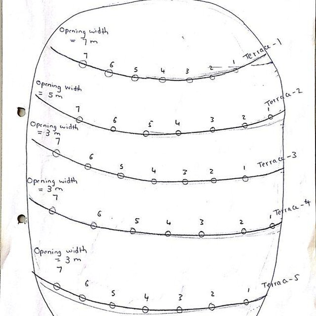
Contour Terraces System (Dr. Adil Khidir, Consultant (Khartoum))
Diversion dam and channal (Abdalla Osman Eisa (Soil Conservaton and Land Use Admin. Port sudan, Sudan.))

การจำแนกประเภทเทคโนโลยี

จุดประสงค์หลัก
  • ปรับปรุงการผลิตให้ดีขึ้น
  • ลด ป้องกัน ฟื้นฟู การเสื่อมโทรมของที่ดิน
  • อนุรักษ์ระบบนิเวศน์
  • ป้องกันพื้นที่ลุ่มน้ำ/บริเวณท้ายน้ำ โดยร่วมกับเทคโนโลยีอื่นๆ
  • รักษาสภาพหรือปรับปรุงความหลากหลายทางชีวภาพ
  • ลดความเสี่ยงของภัยพิบัติ
  • ปรับตัวเข้ากับการเปลี่ยนแปลงภูมิอากาศของโลก สภาพภูมิอากาศที่รุนแรงและผลกระทบ
  • ชะลอการเปลี่ยนแปลงภูมิอากาศของโลกและผลกระทบ
  • สร้างผลกระทบทางด้านเศรษฐกิจที่เป็นประโยชน์
  • สร้างผลกระทบทางด้านสังคมที่เป็นประโยชน์
การใช้ที่ดิน

  • พื้นที่ปลูกพืช
    • การปลูกพืชล้มลุกอายุปีเดียว: cereals - sorghum
    จำนวนของฤดูเพาะปลูกต่อปี: 1
การใช้น้ำ
  • จากน้ำฝน
  • น้ำฝนร่วมกับการชลประทาน
  • การชลประทานแบบเต็มรูปแบบ
  • post-flooding

ความมุ่งหมายที่เกี่ยวข้องกับการเสื่อมโทรมของที่ดิน
  • ป้องกันความเสื่อมโทรมของที่ดิน
  • ลดความเสื่อมโทรมของดิน
  • ฟื้นฟูบำบัดที่ดินที่เสื่อมโทรมลงอย่างมาก
  • ปรับตัวกับสภาพความเสื่อมโทรมของที่ดิน
  • ไม่สามารถใช้ได้
ที่อยู่ของการเสื่อมโทรม
  • การกัดกร่อนของดินโดยน้ำ - Wt (Loss of topsoil): การสูญเสียดินชั้นบนหรือการกัดกร่อนที่ผิวดิน , Wg (Gully erosion): การกัดกร่อนแบบร่องธารหรือการทำให้เกิดร่องน้ำเซาะ, Wo (Offsite degradation): ผลกระทบนอกพื้นที่
กลุ่ม SLM
  • มาตรการปลูกพืชขวางความลาดชัน (cross-slope measure)
  • การผันน้ำและการระบายน้ำ
มาตรการ SLM
  • มาตรการอนุรักษ์ด้วยโครงสร้าง - S2: ทำนบ เขื่อนดิน

แบบแปลนทางเทคนิค

ข้อมูลจำเพาะด้านเทคนิค
None
Author: Dr. Adil Khidir, Fuculty of Engineering, Kartoum University

การจัดตั้งและการบำรุงรักษา: กิจกรรม ปัจจัยและค่าใช้จ่าย

การคำนวนต้นทุนและค่าใช้จ่าย
  • ค่าใช้จ่ายถูกคำนวน
  • สกุลเงินที่ใช้คำนวณค่าใช้จ่าย n.a.
  • อัตราแลกเปลี่ยน (ไปเป็นดอลลาร์สหรัฐ) คือ 1 ดอลลาร์สหรัฐ = ไม่มีคำตอบ
  • ค่าจ้างเฉลี่ยในการจ้างแรงงานต่อวันคือ ไม่มีคำตอบ
ปัจจัยที่สำคัญที่สุดที่มีผลต่อค่าใช้จ่าย
The slope and depth of the wadi/ khor to be diverted
กิจกรรมเพื่อการจัดตั้ง
  1. Excavation of foundation trenches. (ช่วงระยะเวลา/ความถี่: 1 week)
  2. Backfilling with heavy soil (ช่วงระยะเวลา/ความถี่: 1 day)
  3. Establishment diversion structure (ช่วงระยะเวลา/ความถี่: 8 weeks)
  4. Stonepitching by hand (ช่วงระยะเวลา/ความถี่: 3 weeks)
  5. Construction of spillway (ช่วงระยะเวลา/ความถี่: 2 weeks)
ปัจจัยและค่าใช้จ่ายของการจัดตั้ง
ปัจจัยนำเข้า หน่วย ปริมาณ ค่าใช้จ่ายต่อหน่วย (n.a.) ค่าใช้จ่ายทั้งหมดต่อปัจจัยนำเข้า (n.a.) %ของค่าใช้จ่ายที่ก่อให้เกิดขึ้นโดยผู้ใช้ที่ดิน
แรงงาน
labour ha 1.0 57.0 57.0
อุปกรณ์
machine use ha 1.0 355.0 355.0
ค่าใช้จ่ายทั้งหมดของการจัดตั้งเทคโนโลยี 412.0
Total costs for establishment of the Technology in USD 412.0
กิจกรรมสำหรับการบำรุงรักษา
  1. Tillage (ช่วงระยะเวลา/ความถี่: before fluding period)

สิ่งแวดล้อมทางธรรมชาติ

ปริมาณน้ำฝนเฉลี่ยรายปี
  • < 250 ม.ม.
  • 251-500 ม.ม.
  • 501-750 ม.ม.
  • 751-1,000 ม.ม.
  • 1,001-1,500 ม.ม.
  • 1,501-2,000 ม.ม.
  • 2,001-3,000 ม.ม.
  • 3,001-4,000 ม.ม.
  • > 4,000 ม.ม.
เขตภูมิอากาศเกษตร
  • ชื้น
  • กึ่งชุ่มชื้น
  • กึ่งแห้งแล้ง
  • แห้งแล้ง
ข้อมูลจำเพาะเรื่องภูมิอากาศ
Thermal climate class: tropics
ความชัน
  • ราบเรียบ (0-2%)
  • ลาดที่ไม่ชัน (3-5%)
  • ปานกลาง (6-10%)
  • เป็นลูกคลื่น (11-15%)
  • เป็นเนิน (16-30%)
  • ชัน (31-60%)
  • ชันมาก (>60%)
ภูมิลักษณ์
  • ที่ราบสูง/ที่ราบ
  • สันเขา
  • ไหล่เขา
  • ไหล่เนินเขา
  • ตีนเนิน
  • หุบเขา
ความสูง
  • 0-100 เมตร
  • 101-500 เมตร
  • 501-1,000 เมตร
  • 1,001-1,500 เมตร
  • 1,501-2,000 เมตร
  • 2,001-2,500 เมตร
  • 2,501-3,000 เมตร
  • 3,001-4,000 เมตร
  • > 4,000 เมตร
เทคโนโลยีถูกประยุกต์ใช้ใน
  • บริเวณสันเขา (convex situations)
  • บริเวณแอ่งบนที่ราบ (concave situations)
  • ไม่เกี่ยวข้อง
ความลึกของดิน
  • ตื้นมาก (0-20 ซ.ม.)
  • ตื้น (21-50 ซ.ม.)
  • ลึกปานกลาง (51-80 ซ.ม.)
  • ลึก (81-120 ซ.ม.)
  • ลึกมาก (>120 ซ.ม.)
เนื้อดิน (ดินชั้นบน)
  • หยาบ/เบา (ดินทราย)
  • ปานกลาง (ดินร่วน ทรายแป้ง)
  • ละเอียด/หนัก (ดินเหนียว)
เนื้อดิน (> 20 ซม. ต่ำกว่าพื้นผิว)
  • หยาบ/เบา (ดินทราย)
  • ปานกลาง (ดินร่วน ทรายแป้ง)
  • ละเอียด/หนัก (ดินเหนียว)
สารอินทรียวัตถุในดิน
  • สูง (>3%)
  • ปานกลาง (1-3%)
  • ต่ำ (<1%)
น้ำบาดาล
  • ที่ผิวดิน
  • <5 เมตร
  • 5-50 เมตร
  • > 50 เมตร
ระดับน้ำบาดาลที่ผิวดิน
  • เกินพอ
  • ดี
  • ปานกลาง
  • ไม่ดีหรือไม่มีเลย
คุณภาพน้ำ (ยังไม่ได้รับการบำบัด)
  • เป็นน้ำเพื่อการดื่มที่ดี
  • เป็นน้ำเพื่อการดื่มที่ไม่ดี (จำเป็นต้องได้รับการบำบัด)
  • เป็นน้ำใช้เพื่อการเกษตรเท่านั้น (การชลประทาน)
  • ใช้ประโยชน์ไม่ได้
Water quality refers to:
ความเค็มของน้ำเป็นปัญหาหรือไม่?
  • ใช่
  • ไม่ใช่

การเกิดน้ำท่วม
  • ใช่
  • ไม่ใช่
ความหลากหลายทางชนิดพันธุ์
  • สูง
  • ปานกลาง
  • ต่ำ
ความหลากหลายของแหล่งที่อยู่
  • สูง
  • ปานกลาง
  • ต่ำ

ลักษณะเฉพาะของผู้ใช้ที่ดินที่ประยุกต์ใช้เทคโนโลยี

เป้าหมายทางการตลาด
  • เพื่อการยังชีพ (หาเลี้ยงตนเอง)
  • mixed (subsistence/ commercial)
  • ทำการค้า/การตลาด
รายได้จากภายนอกฟาร์ม
  • < 10% ของรายได้ทั้งหมด
  • 10-50% ของรายได้ทั้งหมด
  • > 50% ของรายได้ทั้งหมด
ระดับของความมั่งคั่งโดยเปรียบเทียบ
  • ยากจนมาก
  • จน
  • พอมีพอกิน
  • รวย
  • รวยมาก
ระดับของการใช้เครื่องจักรกล
  • งานที่ใช้แรงกาย
  • การใช้กำลังจากสัตว์
  • การใช้เครื่องจักรหรือเครื่องยนต์
อยู่กับที่หรือเร่ร่อน
  • อยู่กับที่
  • กึ่งเร่ร่อน
  • เร่ร่อน
เป็นรายบุคคลหรือกลุ่ม
  • เป็นรายบุคคล/ครัวเรือน
  • กลุ่ม/ชุมชน
  • สหกรณ์
  • ลูกจ้าง (บริษัท รัฐบาล)
เพศ
  • หญิง
  • ชาย
อายุ
  • เด็ก
  • ผู้เยาว์
  • วัยกลางคน
  • ผู้สูงอายุ
พื้นที่ที่ใช้ต่อครัวเรือน
  • < 0.5 เฮกตาร์
  • 0.5-1 เฮกตาร์
  • 1-2 เฮกตาร์
  • 2-5 เฮกตาร์
  • 5-15 เฮกตาร์
  • 15-50 เฮกตาร์
  • 50-100 เฮกตาร์
  • 100-500 เฮกตาร์
  • 500-1,000 เฮกตาร์
  • 1,000-10,000 เฮกตาร์
  • >10,000 เฮกตาร์
ขนาด
  • ขนาดเล็ก
  • ขนาดกลาง
  • ขนาดใหญ่
กรรมสิทธิ์ในที่ดิน
  • รัฐ
  • บริษัท
  • เป็นแบบชุมชนหรือหมู่บ้าน
  • กลุ่ม
  • รายบุคคล ไม่ได้รับสิทธิครอบครอง
  • รายบุคคล ได้รับสิทธิครอบครอง
สิทธิในการใช้ที่ดิน
  • เข้าถึงได้แบบเปิด (ไม่ได้จัดระเบียบ)
  • เกี่ยวกับชุมชน (ถูกจัดระเบียบ)
  • เช่า
  • รายบุคคล
สิทธิในการใช้น้ำ
  • เข้าถึงได้แบบเปิด (ไม่ได้จัดระเบียบ)
  • เกี่ยวกับชุมชน (ถูกจัดระเบียบ)
  • เช่า
  • รายบุคคล
เข้าถึงการบริการและโครงสร้างพื้นฐาน
สุขภาพ

จน
x
ดี
การศึกษา

จน
x
ดี
ความช่วยเหลือทางด้านเทคนิค

จน
x
ดี
การจ้างงาน (เช่น ภายนอกฟาร์ม)

จน
x
ดี
ตลาด

จน
x
ดี
พลังงาน

จน
x
ดี
ถนนและการขนส่ง

จน
x
ดี
น้ำดื่มและการสุขาภิบาล

จน
x
ดี

ผลกระทบ

ผลกระทบทางด้านเศรษฐกิจและสังคม
การผลิตพืชผล
ลดลง
x
เพิ่มขึ้น


Relative to nothing otherwise

การผลิตพืชที่ใช้เลี้ยงปศุสัตว์
ลดลง
x
เพิ่มขึ้น

การเสี่ยงต่อความล้มเหลวในการผลิต
เพิ่มขึ้น
x
ลดลง

พื้นที่สำหรับการผลิต (ที่ดินใหม่ที่อยู่ในระหว่างเพาะปลูกหรือใช้งาน)
ลดลง
x
เพิ่มขึ้น

การมีน้ำดื่มไว้ให้ใช้
ลดลง
x
เพิ่มขึ้น

รายได้จากฟาร์ม
ลดลง
x
เพิ่มขึ้น

ความหลากหลายของแหล่งผลิตรายได้
ลดลง
x
เพิ่มขึ้น

ผลกระทบด้านสังคมและวัฒนธรรม
ความมั่นคงด้านอาหาร / พึ่งตนเองได้
ลดลง
x
ปรับปรุงดีขึ้น

โอกาสทางวัฒนธรรม (ด้านจิตวิญญาณ ทางศาสนา ด้านสุนทรียภาพ)
ลดลง
x
ปรับปรุงดีขึ้น

โอกาสทางด้านสันทนาการ
ลดลง
x
ปรับปรุงดีขึ้น

สถาบันของชุมชน
อ่อนแอลง
x
เสริมให้แข็งแรง

competition with natural ecosystem
increased
x
decreased


Floodwaters diverted will not reach original destination and those former beneficiaries

contribution to human well-being
decreased
x
increased


Due to more reliable production despite low and variable rainfall

ผลกระทบด้านนิเวศวิทยา
ปริมาณน้ำ
ลดลง
x
เพิ่มขึ้น

คุณภาพน้ำ
ลดลง
x
เพิ่มขึ้น

การเก็บเกี่ยวหรือการกักเก็บน้ำ (น้ำค้างหิมะ)
ลดลง
x
ปรับปรุงดีขึ้น

น้ำไหลบ่าที่ผิวดิน
เพิ่มขึ้น
x
ลดลง

การระเหย
เพิ่มขึ้น
x
ลดลง

ความชื้นในดิน
ลดลง
x
เพิ่มขึ้น

สิ่งปกคลุมดิน
ลดลง
x
ปรับปรุงดีขึ้น

อินทรียวัตถุในดิน/ต่ำกว่าดินชั้น C
ลดลง
x
เพิ่มขึ้น

competition with natural ecosystem
increased
x
decreased


Floodwaters diverted will not reach original destination

ผลกระทบนอกพื้นที่ดำเนินการ
น้ำที่ใช้ประโยชน์ได้ (น้ำบาดาล น้ำพุ)
ลดลง
x
เพิ่มขึ้น

น้ำท่วมพื้นที่ท้ายน้ำ (ที่ไม่เป็นที่ต้องการ)
เพิ่มขึ้น
x
ลดลง

รายได้และค่าใช้จ่าย

ผลประโยชน์ที่ได้รับเปรียบเทียบกับค่าใช้จ่าย
ผลตอบแทนระยะสั้น
ด้านลบอย่างมาก
x
ด้านบวกอย่างมาก

ผลตอบแทนระยะยาว
ด้านลบอย่างมาก
x
ด้านบวกอย่างมาก

ผลประโยชน์ที่ได้รับเปรียบเทียบกับค่าใช้จ่ายในการบำรุงรักษา
no maintenance carried out so not applicable here

การเปลี่ยนแปลงของสภาพภูมิอากาศ

การเปลี่ยนแปลงสภาพภูมิอากาศที่ค่อยเป็นค่อยไป
อุณหภูมิประจำปี เพิ่มขึ้น

ไม่ดี
x
ดีมาก
สภาพรุนแรงของภูมิอากาศ (ภัยพิบัติ)
น้ำท่วมตามปกติ (แม่น้ำ)

ไม่ดี
x
ดีมาก

การน้อมเอาความรู้และการปรับใช้

เปอร์เซ็นต์ของผู้ใช้ที่ดินในพื้นที่ที่นำเทคโนโลยีไปใช้
  • ครั้งเดียวหรือเป็นการทดลอง
  • 1-10%
  • 11-50%
  • > 50%
จากทั้งหมดที่ได้รับเทคโนโลยีเข้ามามีจำนวนเท่าใดที่ทำแบบทันที โดยไม่ได้รับการจูงใจด้านวัสดุหรือการเงินใดๆ?
  • 0-10%
  • 11-50%
  • 51-90%
  • 91-100%
เทคโนโลยีได้รับการปรับเปลี่ยนเร็วๆ นี้เพื่อให้ปรับตัวเข้ากับสภาพที่กำลังเปลี่ยนแปลงหรือไม่?
  • ใช่
  • ไม่ใช่
สภาพที่กำลังเปลี่ยนแปลงอันไหน?
  • การเปลี่ยนแปลงแบบค่อยเป็นค่อยไปและสภาพรุนแรงของภูมิอากาศ
  • การเปลี่ยนแปลงของตลาด
  • การมีแรงงานไว้ให้ใช้ (เนื่องจากการอพยพย้ายถิ่นฐาน)

บทสรุปหรือบทเรียนที่ได้รับ

จุดแข็ง: มุมมองของผู้ใช้ที่ดิน
จุดแข็ง: ทัศนคติของผู้รวบรวมหรือวิทยากรคนอื่นๆ
  • Useful and important in the area where floodwater harvesting/ spate irrigation is the only option for crop production. No rain fed irrigation system on the Red Sea State unlike to other Sudan.
จุดด้อย/ข้อเสีย/ความเสี่ยง: มุมมองของผู้ใช้ที่ดินแก้ไขปัญหาได้อย่างไร
  • SLM not falls under the community responsibility. They believe SLM is completely Gos role. Land users awareness and involvement
  • They don’t think that community plays a role in the ongoing soil and vegetation degradation Rotational grazing and seed broadcasting
  • They also say no regular concern by the government is given in relation to land reclamation A location of budget and equipment to reclaim land and natural vegetation conservation.
  • They confirm that the physical conditions played a great role in land degradation e.g. drought aridity and high temperatures . To ensure water harvesting and without waste.
จุดด้อย/ข้อเสีย/ความเสี่ยง: ทัศนคติของผู้รวบรวมหรือวิทยากรคนอื่นๆแก้ไขปัญหาได้อย่างไร
  • High cost (needs machinery to move earth) More support from Government and outside
  • Not enough trained personnel More up-grading skills are required
  • Very little data available (apart from construction details) Better system of monitoring and evaluation
  • Low technical capacity of the community Capacity building and training

การอ้างอิง

ผู้รวบรวม
  • Abdalla Osman Eisa
Editors
ผู้ตรวจสอบ
  • Deborah Niggli
  • Alexandra Gavilano
วันที่จัดทำเอกสาร: 22 เมษายน 2015
การอัพเดทล่าสุด: 14 สิงหาคม 2019
วิทยากร
คำอธิบายฉบับเต็มในฐานข้อมูล WOCAT
ข้อมูล SLM ที่ถูกอ้างอิง
การจัดทำเอกสารถูกทำโดย
องค์กร โครงการ
This work is licensed under Creative Commons Attribution-NonCommercial-ShareaAlike 4.0 International