Desho Grass Soil Bund (เอธิโอเปีย)

Desho Erken (Amharic)

คำอธิบาย

Desho grass strip is a vegetative SWC measure used for stablizing the bund and provide fodder for animals.

Desho grass is established by planting tillered cuttings. It establishes easily with little soil moisture. It is a perennial herbaceous grass which has massive fibrous root system that anchors the plant to the bind. It provides better cover to the bund and establishes agressively. The growth is upright with a growth potential of 90-120 cm depending on the fertility of the soil and regenerates quickly. It can grow and mature (ready for harvesting) at least once in a month and it requires only one seasontime rain to cover the whole bund.

Purpose of the Technology: The purpose of Desho grass is to stablize the bund and provide palatable grass for livestock.

Establishment / maintenance activities and inputs: Desho grass can be established/regenerate by tiller splitting and planting. The soil should be moist during establishment of Desho grass.

Natural / human environment: Desho grass can grow at 1500-2800 m asl and its best performs at an altitude of 1700-2800m asl.

สถานที่

สถานที่: Sorro/Lintala, Ajacho, SNNPR, เอธิโอเปีย

ตำนวนการวิเคราะห์เทคโนโลยี:

ตำแหน่งทางภูมิศาสตร์ของสถานที่ที่ถูกเลือ
  • 36.7, 6.4

การเผยแพร่ของเทคโนโลยี: กระจายไปอย่างสม่ำเสมอในพื้นที่ (approx. 10-100 ตร.กม.)

In a permanently protected area?:

วันที่ในการดำเนินการ: น้อยกว่า 10 ปี (ไม่นานนี้)

ประเภทของการแนะนำ

การจำแนกประเภทเทคโนโลยี

จุดประสงค์หลัก
  • ปรับปรุงการผลิตให้ดีขึ้น
  • ลด ป้องกัน ฟื้นฟู การเสื่อมโทรมของที่ดิน
  • อนุรักษ์ระบบนิเวศน์
  • ป้องกันพื้นที่ลุ่มน้ำ/บริเวณท้ายน้ำ โดยร่วมกับเทคโนโลยีอื่นๆ
  • รักษาสภาพหรือปรับปรุงความหลากหลายทางชีวภาพ
  • ลดความเสี่ยงของภัยพิบัติ
  • ปรับตัวเข้ากับการเปลี่ยนแปลงภูมิอากาศของโลก สภาพภูมิอากาศที่รุนแรงและผลกระทบ
  • ชะลอการเปลี่ยนแปลงภูมิอากาศของโลกและผลกระทบ
  • สร้างผลกระทบทางด้านเศรษฐกิจที่เป็นประโยชน์
  • สร้างผลกระทบทางด้านสังคมที่เป็นประโยชน์
การใช้ที่ดิน

  • พื้นที่ปลูกพืช
    • การปลูกพืชล้มลุกอายุปีเดียว: cereals - barley, cereals - sorghum, wheat, teff, Irish potato, haricot bean
    • การปลูกพืชยืนต้นที่ไม่มีเนื้อไม้
    • การปลูกไม้ยืนต้น ไม้พุ่ม: avocado, coffee, open grown, Eucalyptus, Cajans cajan, Sesbania sesban, casmir
    จำนวนของฤดูเพาะปลูกต่อปี: 2
  • ทุ่งหญ้าเลี้ยงสัตว์
    • ตัดแล้วขนไป / ไม่มีการปล่อยแทะเล็มเอง (Cut-and-carry / zero grazing)
  • ป่า/พื้นที่ทำไม้ ผลิตภัณฑ์และบริการ: ไม้ซุง, ไม้ที่นำมาทำเป็นเชื้อเพลิง, ผลิตภัณฑ์อื่น ๆ จากป่า, การแทะเล็มหญ้า / การเก็บกินหญ้า
การใช้น้ำ
  • จากน้ำฝน
  • น้ำฝนร่วมกับการชลประทาน
  • การชลประทานแบบเต็มรูปแบบ

ความมุ่งหมายที่เกี่ยวข้องกับการเสื่อมโทรมของที่ดิน
  • ป้องกันความเสื่อมโทรมของที่ดิน
  • ลดความเสื่อมโทรมของดิน
  • ฟื้นฟูบำบัดที่ดินที่เสื่อมโทรมลงอย่างมาก
  • ปรับตัวกับสภาพความเสื่อมโทรมของที่ดิน
  • ไม่สามารถใช้ได้
ที่อยู่ของการเสื่อมโทรม
  • การกัดกร่อนของดินโดยน้ำ - Wt (Loss of topsoil): การสูญเสียดินชั้นบนหรือการกัดกร่อนที่ผิวดิน , Wg (Gully erosion): การกัดกร่อนแบบร่องธารหรือการทำให้เกิดร่องน้ำเซาะ
กลุ่ม SLM
  • การปรับปรุงดิน / พืชคลุมดิน
  • มาตรการปลูกพืชขวางความลาดชัน (cross-slope measure)
มาตรการ SLM

แบบแปลนทางเทคนิค

ข้อมูลจำเพาะด้านเทคนิค
SNNPR

Technical knowledge required for field staff / advisors: moderate

Technical knowledge required for land users: high

Main technical functions: control of dispersed runoff: retain / trap, control of dispersed runoff: impede / retard

Secondary technical functions: control of concentrated runoff: retain / trap, control of concentrated runoff: impede / retard, control of concentrated runoff: drain / divert, reduction of slope length, increase of infiltration, sediment retention / trapping, sediment harvesting

Contour planting / strip cropping
Material/ species: Desho grass
Quantity/ density: 15m3/km
Remarks: 10m X 10m

Contour tillage
Remarks: farm implements

Contour ridging
Remarks: shovel, hoe, pick axe

Aligned: -contour
Vegetative material: T : trees / shrubs, F : fruit trees / shrubs, G : grass
Number of plants per (ha): 750
Vertical interval between rows / strips / blocks (m): 1
Vertical interval within rows / strips / blocks (m): 0.1
Width within rows / strips / blocks (m): 1

Trees/ shrubs species: Cajans cajan, Sesbania sesban

Fruit trees / shrubs species: Avocado, casmir

Grass species: Desho grass

Slope (which determines the spacing indicated above): 30.00%

If the original slope has changed as a result of the Technology, the slope today is (see figure below): 15.00%

Gradient along the rows / strips: 0.00%

Bund/ bank: level
Vertical interval between structures (m): 1
Spacing between structures (m): 20-30
Depth of ditches/pits/dams (m): 0.3
Width of ditches/pits/dams (m): 0.5
Length of ditches/pits/dams (m): 100
Height of bunds/banks/others (m): 0.6
Width of bunds/banks/others (m): 0.8-1.2
Length of bunds/banks/others (m): 100

Structural measure: diversion ditch / cut-off drain
Depth of ditches/pits/dams (m): 0.4
Width of ditches/pits/dams (m): 0.5
Length of ditches/pits/dams (m): 100
Height of bunds/banks/others (m): 0.3
Width of bunds/banks/others (m): 0.5
Length of bunds/banks/others (m): 100

Construction material (earth): Soil bund

Slope (which determines the spacing indicated above): 30%

If the original slope has changed as a result of the Technology, the slope today is: 15%

Lateral gradient along the structure: 0%

Vegetation is used for stabilisation of structures.

Change of land use type: open grazing to cut and carry

Major change in timing of activities: harvesting Desho grass every two month

Other type of management: change of management / intensity level - from mono-crop to rotational cropping

การจัดตั้งและการบำรุงรักษา: กิจกรรม ปัจจัยและค่าใช้จ่าย

การคำนวนต้นทุนและค่าใช้จ่าย
  • ค่าใช้จ่ายถูกคำนวน
  • สกุลเงินที่ใช้คำนวณค่าใช้จ่าย Birr
  • อัตราแลกเปลี่ยน (ไปเป็นดอลลาร์สหรัฐ) คือ 1 ดอลลาร์สหรัฐ = 8.6 Birr
  • ค่าจ้างเฉลี่ยในการจ้างแรงงานต่อวันคือ 0.75
ปัจจัยที่สำคัญที่สุดที่มีผลต่อค่าใช้จ่าย
Cost/labour and requirment increased as slope increased.
กิจกรรมเพื่อการจัดตั้ง
  1. Collecting grass (ช่วงระยะเวลา/ความถี่: beginning of rain season)
  2. Transporting planting materials (ช่วงระยะเวลา/ความถี่: beginning of rain season)
  3. Planting grass on the bund (ช่วงระยะเวลา/ความถี่: beginning of rain season)
  4. Catchment survey (ช่วงระยะเวลา/ความถี่: dry season)
  5. Cutoff drain construction (ช่วงระยะเวลา/ความถี่: dry season)
  6. Soil bund construction (ช่วงระยะเวลา/ความถี่: dry season)
  7. Grass transplanting (ช่วงระยะเวลา/ความถี่: onset of rains)
  8. Grass planting (ช่วงระยะเวลา/ความถี่: onset of rains)
ปัจจัยและค่าใช้จ่ายของการจัดตั้ง
ปัจจัยนำเข้า หน่วย ปริมาณ ค่าใช้จ่ายต่อหน่วย (Birr) ค่าใช้จ่ายทั้งหมดต่อปัจจัยนำเข้า (Birr) %ของค่าใช้จ่ายที่ก่อให้เกิดขึ้นโดยผู้ใช้ที่ดิน
แรงงาน
Labour ha 1.0 8.0 8.0 100.0
อุปกรณ์
Machine use ha 1.0 1.21 1.21
Tools ha 1.0 1.7 1.7
วัสดุด้านพืช
Seedlings ha 1.0 3.2 3.2
ค่าใช้จ่ายทั้งหมดของการจัดตั้งเทคโนโลยี 14.11
Total costs for establishment of the Technology in USD 1.64
กิจกรรมสำหรับการบำรุงรักษา
  1. Land preparation (ช่วงระยะเวลา/ความถี่: onset of rains / 1-3)
  2. Sowing (ช่วงระยะเวลา/ความถี่: during rains / each cropping season)
  3. Weeding (ช่วงระยะเวลา/ความถี่: None)
  4. Collecting grass (ช่วงระยะเวลา/ความถี่: None)
  5. Transporting planting materials (ช่วงระยะเวลา/ความถี่: None)
  6. Planting grass on the bund (ช่วงระยะเวลา/ความถี่: None)
  7. Cutoff drain desilted (ช่วงระยะเวลา/ความถี่: before rains/annual)
  8. Soil bund maintenance (ช่วงระยะเวลา/ความถี่: before rains/annual)
  9. Grass replanting (ช่วงระยะเวลา/ความถี่: during rains/annual)

สิ่งแวดล้อมทางธรรมชาติ

ปริมาณน้ำฝนเฉลี่ยรายปี
  • < 250 ม.ม.
  • 251-500 ม.ม.
  • 501-750 ม.ม.
  • 751-1,000 ม.ม.
  • 1,001-1,500 ม.ม.
  • 1,501-2,000 ม.ม.
  • 2,001-3,000 ม.ม.
  • 3,001-4,000 ม.ม.
  • > 4,000 ม.ม.
เขตภูมิอากาศเกษตร
  • ชื้น
  • กึ่งชุ่มชื้น
  • กึ่งแห้งแล้ง
  • แห้งแล้ง
ข้อมูลจำเพาะเรื่องภูมิอากาศ
1001-1500 (1200 mm, ranked 1)
751-1000 (900 mm, ranked 2)
ความชัน
  • ราบเรียบ (0-2%)
  • ลาดที่ไม่ชัน (3-5%)
  • ปานกลาง (6-10%)
  • เป็นลูกคลื่น (11-15%)
  • เป็นเนิน (16-30%)
  • ชัน (31-60%)
  • ชันมาก (>60%)
ภูมิลักษณ์
  • ที่ราบสูง/ที่ราบ
  • สันเขา
  • ไหล่เขา
  • ไหล่เนินเขา
  • ตีนเนิน
  • หุบเขา
ความสูง
  • 0-100 เมตร
  • 101-500 เมตร
  • 501-1,000 เมตร
  • 1,001-1,500 เมตร
  • 1,501-2,000 เมตร
  • 2,001-2,500 เมตร
  • 2,501-3,000 เมตร
  • 3,001-4,000 เมตร
  • > 4,000 เมตร
เทคโนโลยีถูกประยุกต์ใช้ใน
  • บริเวณสันเขา (convex situations)
  • บริเวณแอ่งบนที่ราบ (concave situations)
  • ไม่เกี่ยวข้อง
ความลึกของดิน
  • ตื้นมาก (0-20 ซ.ม.)
  • ตื้น (21-50 ซ.ม.)
  • ลึกปานกลาง (51-80 ซ.ม.)
  • ลึก (81-120 ซ.ม.)
  • ลึกมาก (>120 ซ.ม.)
เนื้อดิน (ดินชั้นบน)
  • หยาบ/เบา (ดินทราย)
  • ปานกลาง (ดินร่วน ทรายแป้ง)
  • ละเอียด/หนัก (ดินเหนียว)
เนื้อดิน (> 20 ซม. ต่ำกว่าพื้นผิว)
  • หยาบ/เบา (ดินทราย)
  • ปานกลาง (ดินร่วน ทรายแป้ง)
  • ละเอียด/หนัก (ดินเหนียว)
สารอินทรียวัตถุในดิน
  • สูง (>3%)
  • ปานกลาง (1-3%)
  • ต่ำ (<1%)
น้ำบาดาล
  • ที่ผิวดิน
  • <5 เมตร
  • 5-50 เมตร
  • > 50 เมตร
ระดับน้ำบาดาลที่ผิวดิน
  • เกินพอ
  • ดี
  • ปานกลาง
  • ไม่ดีหรือไม่มีเลย
คุณภาพน้ำ (ยังไม่ได้รับการบำบัด)
  • เป็นน้ำเพื่อการดื่มที่ดี
  • เป็นน้ำเพื่อการดื่มที่ไม่ดี (จำเป็นต้องได้รับการบำบัด)
  • เป็นน้ำใช้เพื่อการเกษตรเท่านั้น (การชลประทาน)
  • ใช้ประโยชน์ไม่ได้
ความเค็มของน้ำเป็นปัญหาหรือไม่?
  • ใช่
  • ไม่ใช่

การเกิดน้ำท่วม
  • ใช่
  • ไม่ใช่
ความหลากหลายทางชนิดพันธุ์
  • สูง
  • ปานกลาง
  • ต่ำ
ความหลากหลายของแหล่งที่อยู่
  • สูง
  • ปานกลาง
  • ต่ำ

ลักษณะเฉพาะของผู้ใช้ที่ดินที่ประยุกต์ใช้เทคโนโลยี

เป้าหมายทางการตลาด
  • เพื่อการยังชีพ (หาเลี้ยงตนเอง)
  • mixed (subsistence/ commercial)
  • ทำการค้า/การตลาด
รายได้จากภายนอกฟาร์ม
  • < 10% ของรายได้ทั้งหมด
  • 10-50% ของรายได้ทั้งหมด
  • > 50% ของรายได้ทั้งหมด
ระดับของความมั่งคั่งโดยเปรียบเทียบ
  • ยากจนมาก
  • จน
  • พอมีพอกิน
  • รวย
  • รวยมาก
ระดับของการใช้เครื่องจักรกล
  • งานที่ใช้แรงกาย
  • การใช้กำลังจากสัตว์
  • การใช้เครื่องจักรหรือเครื่องยนต์
อยู่กับที่หรือเร่ร่อน
  • อยู่กับที่
  • กึ่งเร่ร่อน
  • เร่ร่อน
เป็นรายบุคคลหรือกลุ่ม
  • เป็นรายบุคคล/ครัวเรือน
  • กลุ่ม/ชุมชน
  • สหกรณ์
  • ลูกจ้าง (บริษัท รัฐบาล)
เพศ
  • หญิง
  • ชาย
อายุ
  • เด็ก
  • ผู้เยาว์
  • วัยกลางคน
  • ผู้สูงอายุ
พื้นที่ที่ใช้ต่อครัวเรือน
  • < 0.5 เฮกตาร์
  • 0.5-1 เฮกตาร์
  • 1-2 เฮกตาร์
  • 2-5 เฮกตาร์
  • 5-15 เฮกตาร์
  • 15-50 เฮกตาร์
  • 50-100 เฮกตาร์
  • 100-500 เฮกตาร์
  • 500-1,000 เฮกตาร์
  • 1,000-10,000 เฮกตาร์
  • >10,000 เฮกตาร์
ขนาด
  • ขนาดเล็ก
  • ขนาดกลาง
  • ขนาดใหญ่
กรรมสิทธิ์ในที่ดิน
  • รัฐ
  • บริษัท
  • เป็นแบบชุมชนหรือหมู่บ้าน
  • กลุ่ม
  • รายบุคคล ไม่ได้รับสิทธิครอบครอง
  • รายบุคคล ได้รับสิทธิครอบครอง
สิทธิในการใช้ที่ดิน
  • เข้าถึงได้แบบเปิด (ไม่ได้จัดระเบียบ)
  • เกี่ยวกับชุมชน (ถูกจัดระเบียบ)
  • เช่า
  • รายบุคคล
สิทธิในการใช้น้ำ
  • เข้าถึงได้แบบเปิด (ไม่ได้จัดระเบียบ)
  • เกี่ยวกับชุมชน (ถูกจัดระเบียบ)
  • เช่า
  • รายบุคคล
เข้าถึงการบริการและโครงสร้างพื้นฐาน

ผลกระทบ

ผลกระทบทางด้านเศรษฐกิจและสังคม
การผลิตพืชผล
ลดลง
x
เพิ่มขึ้น


land productivity is improved

การผลิตพืชที่ใช้เลี้ยงปศุสัตว์
ลดลง
x
เพิ่มขึ้น


desho grass became ample forage resources

คุณภาพพืชที่ใช้เลี้ยงปศุสัตว์
ลดลง
x
เพิ่มขึ้น


desho grass became ample forage resources

การผลิตไม้
ลดลง
x
เพิ่มขึ้น

รายได้จากฟาร์ม
ลดลง
x
เพิ่มขึ้น


from sells of Desho grass and animal product

ผลกระทบด้านสังคมและวัฒนธรรม
สถาบันของชุมชน
อ่อนแอลง
x
เสริมให้แข็งแรง


strengthen group working, e.g. community development committee (CDC)

สถาบันแห่งชาติ
อ่อนแอลง
x
เสริมให้แข็งแรง


Introduce strong approach, Integrated Watershed Management

SLM หรือความรู้เรื่องความเสื่อมโทรมของที่ดิน
ลดลง
x
ปรับปรุงดีขึ้น


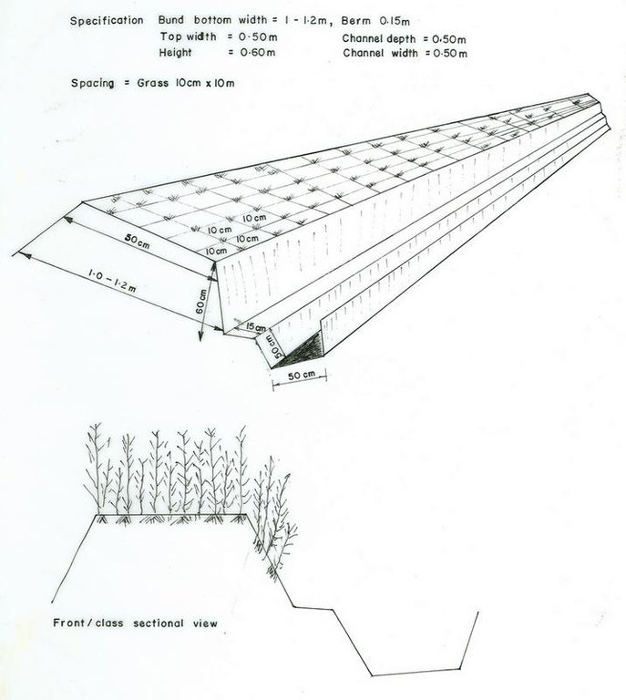
use of Desho grass for bund stablization

ผลกระทบด้านนิเวศวิทยา
ความชื้นในดิน
ลดลง
x
เพิ่มขึ้น


excess water is retained behind the bund and infiltrate

สิ่งปกคลุมดิน
ลดลง
x
ปรับปรุงดีขึ้น


Desho grass cover the bund

การสูญเสียดิน
เพิ่มขึ้น
x
ลดลง

จำนวนก่อน SLM: 70
หลังจาก SLM: 4
bund stablized with Desho grass is effctive in conserving the soil

ผลกระทบนอกพื้นที่ดำเนินการ
น้ำท่วมพื้นที่ท้ายน้ำ (ที่ไม่เป็นที่ต้องการ)
เพิ่มขึ้น
x
ลดลง


reduce flooding

การทับถมของดินตะกอนพื้นที่ท้ายน้ำ
เพิ่มขึ้น
x
ลดลง

การเกิดมลพิษในน้ำบาดาลหรือแม่น้ำ
เพิ่มขึ้น
x
ลดลง

รายได้และค่าใช้จ่าย

ผลประโยชน์ที่ได้รับเปรียบเทียบกับค่าใช้จ่าย
ผลตอบแทนระยะสั้น
ด้านลบอย่างมาก
x
ด้านบวกอย่างมาก

ผลตอบแทนระยะยาว
ด้านลบอย่างมาก
x
ด้านบวกอย่างมาก

ผลประโยชน์ที่ได้รับเปรียบเทียบกับค่าใช้จ่ายในการบำรุงรักษา
ผลตอบแทนระยะสั้น
ด้านลบอย่างมาก
x
ด้านบวกอย่างมาก

ผลตอบแทนระยะยาว
ด้านลบอย่างมาก
x
ด้านบวกอย่างมาก

การเปลี่ยนแปลงของสภาพภูมิอากาศ

-

การน้อมเอาความรู้และการปรับใช้

เปอร์เซ็นต์ของผู้ใช้ที่ดินในพื้นที่ที่นำเทคโนโลยีไปใช้
  • ครั้งเดียวหรือเป็นการทดลอง
  • 1-10%
  • 11-50%
  • > 50%
จากทั้งหมดที่ได้รับเทคโนโลยีเข้ามามีจำนวนเท่าใดที่ทำแบบทันที โดยไม่ได้รับการจูงใจด้านวัสดุหรือการเงินใดๆ?
  • 0-10%
  • 11-50%
  • 51-90%
  • 91-100%
เทคโนโลยีได้รับการปรับเปลี่ยนเร็วๆ นี้เพื่อให้ปรับตัวเข้ากับสภาพที่กำลังเปลี่ยนแปลงหรือไม่?
  • ใช่
  • ไม่ใช่
สภาพที่กำลังเปลี่ยนแปลงอันไหน?
  • การเปลี่ยนแปลงแบบค่อยเป็นค่อยไปและสภาพรุนแรงของภูมิอากาศ
  • การเปลี่ยนแปลงของตลาด
  • การมีแรงงานไว้ให้ใช้ (เนื่องจากการอพยพย้ายถิ่นฐาน)

บทสรุปหรือบทเรียนที่ได้รับ

จุดแข็ง: มุมมองของผู้ใช้ที่ดิน
  • Palatable grass

    How can they be sustained / enhanced? encourage cut and carry system.
  • fast growing grass
  • Substitute enset as a source of forage
  • Generate income
จุดแข็ง: ทัศนคติของผู้รวบรวมหรือวิทยากรคนอื่นๆ
  • Good and fast growing grass that can cover the bund with in short time.

    How can they be sustained / enhanced? avoid free grazing and encourage cut and carry system.
  • Little investment for establishment

    How can they be sustained / enhanced? Provision of planting materials for resource poor land users.
  • Good palatable nature

    How can they be sustained / enhanced? encourage cut and carry system.
  • Land productivity improved

    How can they be sustained / enhanced? access to market and introduce improved varities.
จุดด้อย/ข้อเสีย/ความเสี่ยง: มุมมองของผู้ใช้ที่ดินแก้ไขปัญหาได้อย่างไร
จุดด้อย/ข้อเสีย/ความเสี่ยง: ทัศนคติของผู้รวบรวมหรือวิทยากรคนอื่นๆแก้ไขปัญหาได้อย่างไร

การอ้างอิง

ผู้รวบรวม
  • Daniel Danano
Editors
ผู้ตรวจสอบ
  • Fabian Ottiger
  • Alexandra Gavilano
วันที่จัดทำเอกสาร: 30 พฤษภาคม 2011
การอัพเดทล่าสุด: 10 กันยายน 2019
วิทยากร
คำอธิบายฉบับเต็มในฐานข้อมูล WOCAT
ข้อมูล SLM ที่ถูกอ้างอิง
การจัดทำเอกสารถูกทำโดย
องค์กร โครงการ
การอ้งอิงหลัก
  • SOS Sahel IFSSP Terminal evaluation Report. 2003.:
  • Case study assessing the signifcance of Desho grass intervention on SWC structures, Food security Strategy, by Daniel Dantamo.:
This work is licensed under Creative Commons Attribution-NonCommercial-ShareaAlike 4.0 International