River training dam
(ทาจิกิสถาน)
Дамбаи Обпартоб
คำอธิบาย
The river training dam is a disaster mitigation structure protecting downstream areas from flash floods and mudflows. It consists of a channel dug and wire net gabions built to train the river and is hence cheap to establish and maintain. There is a substantial community contribution as labour is an important part of the input costs. The dam enables the rehabilitation of unproductive land in the downstream catchment areas, reduction of crop pests, increase in crop diversity and land productivity, and an overall improvement of livelihoods for downstream communities through reduced vulnerability to disasters.
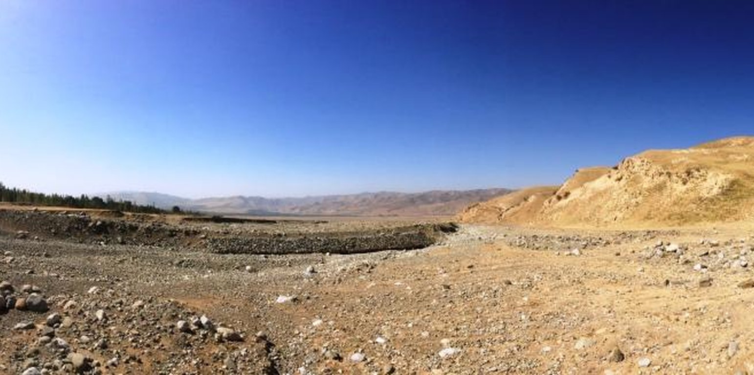
The river training dam is a disaster mitigation structure constructed in the middle zone of the watershed of Obishur (Southern Tajikistan), at 1400 metres above sea level. It is diverting the water from the river fan naturally flowing through Kulchashma village into a different direction and river outlet (Yakhsu river). The dike is a simple structure consisting of a 400m-long and 4m-high channel dug by bulldozer consolidated by a 60m-long and 3m-wide gabion protecting a sharp curve of the river. The material needed is limited to stones and wire net, and the construction as well as maintenance costs are hence low and don't need a too high amount of labour, provided by the communities as in-kind contribution. The structure is built to resist a pressure of up to 72 m3/sec. Given the annual frequency and strength of the local floods, the Kulchashma river training dam has an estimated life expectancy of 30 years. The land users proposed to establish the dam in order to protect the 250 households and 270 ha of land downstream being regularly affected by the floods. In particular, people, houses, roads and other infrastructure, crop and pasture land as well as animals and other assets were highly exposed to the risk of flood. The agricultural production, constituting the main part of people’s income was hindered by the regular occurrence of disasters. The establishment of the river training dam resulted in the rehabilitation of unproductive land in the river fan and its use as pasture and arable land which the community mainly uses for agroforestry. The occurrence of crop pests decreased, the crop diversity was increased, the crop and land productivity improved, thereby enhancing the land users’ food security and overall income. The dam also allowed vulnerable community members to access land and build houses. The construction of buildings behind the dam is however risky and communities tend to forget or ignore that a risk of failure of the dam persists, and that its life expectancy is limited. But first of all, the personal safety of the community members is now improved and they are happy to be able to sleep without the fear of regular floods.
สถานที่
สถานที่: Kulchashma Jamoat, Kulchashma village, Khatlon Region, Muminabad District, ทาจิกิสถาน
ตำนวนการวิเคราะห์เทคโนโลยี: พื้นที่เดี่ยว
ตำแหน่งทางภูมิศาสตร์ของสถานที่ที่ถูกเลือ
การเผยแพร่ของเทคโนโลยี: ใช้ ณ จุดที่เฉพาะเจาะจงหรือเน้นไปยังบริเวณพื้นที่ขนาดเล็ก
In a permanently protected area?:
วันที่ในการดำเนินการ: 2014
ประเภทของการแนะนำ
-
ด้วยการริเริ่มของผู้ใช้ที่ดินเอง
-
เป็นส่วนหนึ่งของระบบแบบดั้งเดิมที่ทำก้นอยู่ (> 50 ปี)
-
ในช่วงการทดลองหรือการทำวิจัย
-
ทางโครงการหรือจากภายนอก
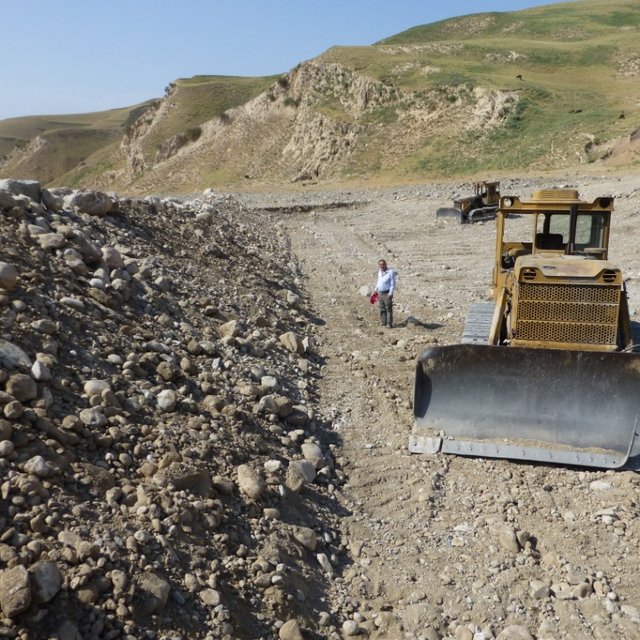
Deepening the water channel with bulldozers before building gabions to reinforce the riverbed (Sa'dy Odinashoev)
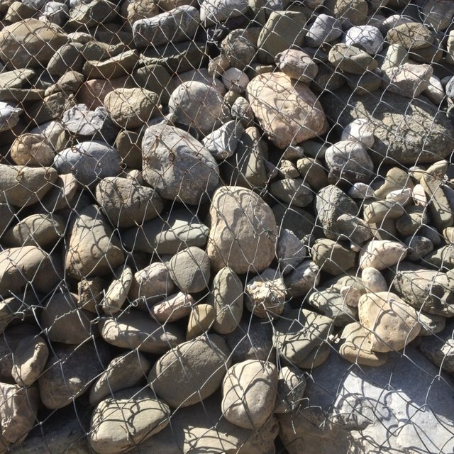
Wire net gabions constructed to reinforce the dam infrastructure in the sharp curve of the river. (Margaux Tharin)
จุดประสงค์หลัก
-
ปรับปรุงการผลิตให้ดีขึ้น
-
ลด ป้องกัน ฟื้นฟู การเสื่อมโทรมของที่ดิน
-
อนุรักษ์ระบบนิเวศน์
-
ป้องกันพื้นที่ลุ่มน้ำ/บริเวณท้ายน้ำ โดยร่วมกับเทคโนโลยีอื่นๆ
-
รักษาสภาพหรือปรับปรุงความหลากหลายทางชีวภาพ
-
ลดความเสี่ยงของภัยพิบัติ
-
ปรับตัวเข้ากับการเปลี่ยนแปลงภูมิอากาศของโลก สภาพภูมิอากาศที่รุนแรงและผลกระทบ
-
ชะลอการเปลี่ยนแปลงภูมิอากาศของโลกและผลกระทบ
-
สร้างผลกระทบทางด้านเศรษฐกิจที่เป็นประโยชน์
-
สร้างผลกระทบทางด้านสังคมที่เป็นประโยชน์
การใช้ที่ดิน
-
ทุ่งหญ้าเลี้ยงสัตว์
- กึ่งโนแมนดิซึ่มหรือแพสโตแรลลิซึ่ม (Semi-nomadism/pastoralism)
การใช้น้ำ
-
จากน้ำฝน
-
น้ำฝนร่วมกับการชลประทาน
-
การชลประทานแบบเต็มรูปแบบ
ความมุ่งหมายที่เกี่ยวข้องกับการเสื่อมโทรมของที่ดิน
-
ป้องกันความเสื่อมโทรมของที่ดิน
-
ลดความเสื่อมโทรมของดิน
-
ฟื้นฟูบำบัดที่ดินที่เสื่อมโทรมลงอย่างมาก
-
ปรับตัวกับสภาพความเสื่อมโทรมของที่ดิน
-
ไม่สามารถใช้ได้
ที่อยู่ของการเสื่อมโทรม
-
การกัดกร่อนของดินโดยน้ำ - Wt (Loss of topsoil): การสูญเสียดินชั้นบนหรือการกัดกร่อนที่ผิวดิน , Wg (Gully erosion): การกัดกร่อนแบบร่องธารหรือการทำให้เกิดร่องน้ำเซาะ, Wr (Riverbank erosion): การกัดกร่อนริมฝั่งแม่น้ำ, Wo (Offsite degradation): ผลกระทบนอกพื้นที่
-
การเสื่อมโทรมของดินทางด้านชีวภาพ - Bc (Reduction of vegetation cover): การลดลงของจำนวนพืชที่ปกคลุมดิน , Bh (Loss of habitat): การสูญเสียแหล่งที่อยู่, Bq (Quantity/biomass decline): การลดลงของปริมาณหรือมวลชีวภาพ, Bl (Loss of soil life): การสูญเสียสิ่งมีชีวิตในดิน , Bp (Increase of pests/diseases): การเพิ่มขึ้นของศัตรูพืชและโรคพืช
-
การเสื่อมโทรมของน้ำ - Hs (Change in quantity of surface water): การเปลี่ยนแปลงปริมาณของน้ำที่ผิวดิน, Hp (Decline of surface water quality): การลดลงของคุณภาพน้ำที่ผิวดิน, Hq (Decline of groundwater quality): การลดลงของคุณภาพน้ำบาดาล
มาตรการ SLM
-
มาตรการอนุรักษ์ด้วยโครงสร้าง - S3: Graded ditches, channels, waterways, S5: เขื่อน ชั้นดินที่แน่นแข็งบ่อน้ำ
แบบแปลนทางเทคนิค
ข้อมูลจำเพาะด้านเทคนิค
การจัดตั้งและการบำรุงรักษา: กิจกรรม ปัจจัยและค่าใช้จ่าย
การคำนวนต้นทุนและค่าใช้จ่าย
- ค่าใช้จ่ายถูกคำนวน ต่อหน่วยเทคโนโลยี (หน่วย: Dam volume, length: 400m-long dug channel and 60m-long gabion)
- สกุลเงินที่ใช้คำนวณค่าใช้จ่าย USD
- อัตราแลกเปลี่ยน (ไปเป็นดอลลาร์สหรัฐ) คือ 1 ดอลลาร์สหรัฐ = ไม่มีคำตอบ
- ค่าจ้างเฉลี่ยในการจ้างแรงงานต่อวันคือ ไม่มีคำตอบ
ปัจจัยที่สำคัญที่สุดที่มีผลต่อค่าใช้จ่าย
- Geography (steep hills to dig a diverting channel increases the establishment costs)
- Geology (quality/type of soil affects the time needed for digging)
กิจกรรมเพื่อการจัดตั้ง
-
400m-long channel digging (bulldozer) (ช่วงระยะเวลา/ความถี่: August-October)
-
Stone collection (ช่วงระยะเวลา/ความถี่: October (10 days))
-
Construction of gabions (ช่วงระยะเวลา/ความถี่: November (15 days))
ปัจจัยและค่าใช้จ่ายของการจัดตั้ง (per Dam)
| ปัจจัยนำเข้า |
หน่วย |
ปริมาณ |
ค่าใช้จ่ายต่อหน่วย (USD) |
ค่าใช้จ่ายทั้งหมดต่อปัจจัยนำเข้า (USD) |
%ของค่าใช้จ่ายที่ก่อให้เกิดขึ้นโดยผู้ใช้ที่ดิน |
|
แรงงาน
|
| Construction of wire net gabions |
person-hours |
1400.0 |
1.5 |
2100.0 |
100.0 |
| Bulldozer driving |
person-hours |
150.0 |
1.5 |
225.0 |
|
|
อุปกรณ์
|
| Bulldozer rent |
day |
15.0 |
63.0 |
945.0 |
|
| Fuel for bulldozer |
litre |
2250.0 |
1.35 |
3037.5 |
|
| Diesel oil for bulldozer |
litre |
68.0 |
2.13 |
144.84 |
|
| Spindle oil for bulldozer |
litre |
45.0 |
2.0 |
90.0 |
|
|
วัสดุสำหรับก่อสร้าง
|
| wire net (diametre 4mm) |
m2 |
625.0 |
1.6 |
1000.0 |
|
| wire (diametre 3mm) |
kg |
26.0 |
1.6 |
41.6 |
|
|
อื่น ๆ
|
| Gearbox oil for bulldozer |
litre |
22.0 |
2.5 |
55.0 |
|
| Solid oil for bulldozer |
litre |
22.0 |
3.0 |
66.0 |
|
| Gas for bulldozer |
litre |
22.0 |
1.4 |
30.8 |
|
| ค่าใช้จ่ายทั้งหมดของการจัดตั้งเทคโนโลยี |
7'735.74 |
|
| Total costs for establishment of the Technology in USD |
7'735.74 |
|
กิจกรรมสำหรับการบำรุงรักษา
-
Fixing of wire net gabions (ช่วงระยะเวลา/ความถี่: March, annually)
ปัจจัยและค่าใช้จ่ายของการบำรุงรักษา (per Dam)
| ปัจจัยนำเข้า |
หน่วย |
ปริมาณ |
ค่าใช้จ่ายต่อหน่วย (USD) |
ค่าใช้จ่ายทั้งหมดต่อปัจจัยนำเข้า (USD) |
%ของค่าใช้จ่ายที่ก่อให้เกิดขึ้นโดยผู้ใช้ที่ดิน |
|
แรงงาน
|
| Fixing wire net (by Self Help Group) |
hour |
40.0 |
0.8 |
32.0 |
100.0 |
|
วัสดุสำหรับก่อสร้าง
|
| wire net |
kg |
7.0 |
1.0 |
7.0 |
100.0 |
| ค่าใช้จ่ายทั้งหมดของการบำรุงรักษาสภาพเทคโนโลยี |
39.0 |
|
| Total costs for maintenance of the Technology in USD |
39.0 |
|
สิ่งแวดล้อมทางธรรมชาติ
ปริมาณน้ำฝนเฉลี่ยรายปี
-
< 250 ม.ม.
-
251-500 ม.ม.
-
501-750 ม.ม.
-
751-1,000 ม.ม.
-
1,001-1,500 ม.ม.
-
1,501-2,000 ม.ม.
-
2,001-3,000 ม.ม.
-
3,001-4,000 ม.ม.
-
> 4,000 ม.ม.
เขตภูมิอากาศเกษตร
-
ชื้น
-
กึ่งชุ่มชื้น
-
กึ่งแห้งแล้ง
-
แห้งแล้ง
ข้อมูลจำเพาะเรื่องภูมิอากาศ
Varies very much from year to year.
ชื่อสถานีอุตุนิยมวิทยา Muminabad meteo station (1200 m a.s.l.)
Average temperatures:
Spring:10-32°C
Summer: 20-35°C
Autumn: 10-32°C
Winter: -5-+5°C
Average yearly temperature: 11.1°C
ความชัน
-
ราบเรียบ (0-2%)
-
ลาดที่ไม่ชัน (3-5%)
-
ปานกลาง (6-10%)
-
เป็นลูกคลื่น (11-15%)
-
เป็นเนิน (16-30%)
-
ชัน (31-60%)
-
ชันมาก (>60%)
ภูมิลักษณ์
-
ที่ราบสูง/ที่ราบ
-
สันเขา
-
ไหล่เขา
-
ไหล่เนินเขา
-
ตีนเนิน
-
หุบเขา
ความสูง
-
0-100 เมตร
-
101-500 เมตร
-
501-1,000 เมตร
-
1,001-1,500 เมตร
-
1,501-2,000 เมตร
-
2,001-2,500 เมตร
-
2,501-3,000 เมตร
-
3,001-4,000 เมตร
-
> 4,000 เมตร
เทคโนโลยีถูกประยุกต์ใช้ใน
-
บริเวณสันเขา (convex situations)
-
บริเวณแอ่งบนที่ราบ (concave situations)
-
ไม่เกี่ยวข้อง
ความลึกของดิน
-
ตื้นมาก (0-20 ซ.ม.)
-
ตื้น (21-50 ซ.ม.)
-
ลึกปานกลาง (51-80 ซ.ม.)
-
ลึก (81-120 ซ.ม.)
-
ลึกมาก (>120 ซ.ม.)
เนื้อดิน (ดินชั้นบน)
-
หยาบ/เบา (ดินทราย)
-
ปานกลาง (ดินร่วน ทรายแป้ง)
-
ละเอียด/หนัก (ดินเหนียว)
เนื้อดิน (> 20 ซม. ต่ำกว่าพื้นผิว)
-
หยาบ/เบา (ดินทราย)
-
ปานกลาง (ดินร่วน ทรายแป้ง)
-
ละเอียด/หนัก (ดินเหนียว)
สารอินทรียวัตถุในดิน
-
สูง (>3%)
-
ปานกลาง (1-3%)
-
ต่ำ (<1%)
น้ำบาดาล
-
ที่ผิวดิน
-
<5 เมตร
-
5-50 เมตร
-
> 50 เมตร
ระดับน้ำบาดาลที่ผิวดิน
-
เกินพอ
-
ดี
-
ปานกลาง
-
ไม่ดีหรือไม่มีเลย
คุณภาพน้ำ (ยังไม่ได้รับการบำบัด)
-
เป็นน้ำเพื่อการดื่มที่ดี
-
เป็นน้ำเพื่อการดื่มที่ไม่ดี (จำเป็นต้องได้รับการบำบัด)
-
เป็นน้ำใช้เพื่อการเกษตรเท่านั้น (การชลประทาน)
-
ใช้ประโยชน์ไม่ได้
Water quality refers to:
ความเค็มของน้ำเป็นปัญหาหรือไม่?
การเกิดน้ำท่วม
ความหลากหลายทางชนิดพันธุ์
ความหลากหลายของแหล่งที่อยู่
ลักษณะเฉพาะของผู้ใช้ที่ดินที่ประยุกต์ใช้เทคโนโลยี
เป้าหมายทางการตลาด
-
เพื่อการยังชีพ (หาเลี้ยงตนเอง)
-
mixed (subsistence/ commercial)
-
ทำการค้า/การตลาด
รายได้จากภายนอกฟาร์ม
-
< 10% ของรายได้ทั้งหมด
-
10-50% ของรายได้ทั้งหมด
-
> 50% ของรายได้ทั้งหมด
ระดับของความมั่งคั่งโดยเปรียบเทียบ
-
ยากจนมาก
-
จน
-
พอมีพอกิน
-
รวย
-
รวยมาก
ระดับของการใช้เครื่องจักรกล
-
งานที่ใช้แรงกาย
-
การใช้กำลังจากสัตว์
-
การใช้เครื่องจักรหรือเครื่องยนต์
อยู่กับที่หรือเร่ร่อน
-
อยู่กับที่
-
กึ่งเร่ร่อน
-
เร่ร่อน
เป็นรายบุคคลหรือกลุ่ม
-
เป็นรายบุคคล/ครัวเรือน
-
กลุ่ม/ชุมชน
-
สหกรณ์
-
ลูกจ้าง (บริษัท รัฐบาล)
อายุ
-
เด็ก
-
ผู้เยาว์
-
วัยกลางคน
-
ผู้สูงอายุ
พื้นที่ที่ใช้ต่อครัวเรือน
-
< 0.5 เฮกตาร์
-
0.5-1 เฮกตาร์
-
1-2 เฮกตาร์
-
2-5 เฮกตาร์
-
5-15 เฮกตาร์
-
15-50 เฮกตาร์
-
50-100 เฮกตาร์
-
100-500 เฮกตาร์
-
500-1,000 เฮกตาร์
-
1,000-10,000 เฮกตาร์
-
>10,000 เฮกตาร์
ขนาด
-
ขนาดเล็ก
-
ขนาดกลาง
-
ขนาดใหญ่
กรรมสิทธิ์ในที่ดิน
-
รัฐ
-
บริษัท
-
เป็นแบบชุมชนหรือหมู่บ้าน
-
กลุ่ม
-
รายบุคคล ไม่ได้รับสิทธิครอบครอง
-
รายบุคคล ได้รับสิทธิครอบครอง
สิทธิในการใช้ที่ดิน
-
เข้าถึงได้แบบเปิด (ไม่ได้จัดระเบียบ)
-
เกี่ยวกับชุมชน (ถูกจัดระเบียบ)
-
เช่า
-
รายบุคคล
สิทธิในการใช้น้ำ
-
เข้าถึงได้แบบเปิด (ไม่ได้จัดระเบียบ)
-
เกี่ยวกับชุมชน (ถูกจัดระเบียบ)
-
เช่า
-
รายบุคคล
เข้าถึงการบริการและโครงสร้างพื้นฐาน
ความช่วยเหลือทางด้านเทคนิค
การจ้างงาน (เช่น ภายนอกฟาร์ม)
ผลกระทบ
ผลกระทบทางด้านเศรษฐกิจและสังคม
การผลิตพืชผล
จำนวนก่อน SLM: No production
หลังจาก SLM: Self-use + surplus sold on market
6000 kg onions/ ha
การผลิตพืชที่ใช้เลี้ยงปศุสัตว์
On average 50% increase of fodder. Additionally, fodder crop seeds (lucerne) can be sold; increases land users' income.
คุณภาพพืชที่ใช้เลี้ยงปศุสัตว์
การเสี่ยงต่อความล้มเหลวในการผลิต
One of the main and most important impact
พื้นที่สำหรับการผลิต (ที่ดินใหม่ที่อยู่ในระหว่างเพาะปลูกหรือใช้งาน)
25-30% increase in production area in lowlands (downstream) through rehabilitation of unproductive land which was previously regularly flooded and covered by sediments.
การจัดการที่ดิน
Trees newly planted are used for riverbed protection and fuelwood production
การมีน้ำดื่มไว้ให้ใช้
Floods do not contaminate spring drinking waters with sediments
การมีน้ำไว้ให้สำหรับการชลประทาน
Irrigation channel not destroyed by annual floods anymore.
ค่าใช่จ่ายของปัจจัยการผลิตทางการเกษตร
รายได้จากฟาร์ม
Through rehabilitation of unproductive land in river fan.
ความหลากหลายของแหล่งผลิตรายได้
ผลกระทบด้านสังคมและวัฒนธรรม
ความมั่นคงด้านอาหาร / พึ่งตนเองได้
Cultivation of wheat plots and vegetables for self-use and sale
การใช้ที่ดิน / สิทธิในการใช้น้ำ
Previously unused land in the river fan is now registered as pasture land with a land certificate for the use of the community, and new houses where also built on this land.
สถาบันของชุมชน
Taxes can be collected with the registration and certification of pasture land and with the authorisation of house construction.
SLM หรือความรู้เรื่องความเสื่อมโทรมของที่ดิน
สถานการณ์ของกลุ่มด้อยโอกาส ทางด้านสังคมและเศรษฐกิจ (เพศ อายุ สถานภาพ ความเป็นกลุ่มทางชาติพันธุ์)
With dam constructed, economically disadvantaged people have space for building a house on the rehabilitated land.
ผลกระทบด้านนิเวศวิทยา
การหมุนเวียนและการเติมของธาตุอาหาร
อินทรียวัตถุในดิน/ต่ำกว่าดินชั้น C
ความหลากหลายทางชีวภาพของพืช
การจัดการศัตรูพืชและโรคพืช
ดินถล่ม/ ซากต่าง ๆ ที่ถูกพัดพามา
ผลกระทบนอกพื้นที่ดำเนินการ
การไหลของน้ำคงที่และสม่ำเสมอในช่วงฤดูแล้ง(รวมถึงการไหลน้อย)
น้ำท่วมพื้นที่ท้ายน้ำ (ที่ไม่เป็นที่ต้องการ)
การทับถมของดินตะกอนพื้นที่ท้ายน้ำ
ความเสียหายต่อพื้นที่เพาะปลูกของเพื่อนบ้าน
ความเสียหายต่อโครงสร้างพื้นฐานของรัฐหรือของเอกชน
รายได้และค่าใช้จ่าย
ผลประโยชน์ที่ได้รับเปรียบเทียบกับค่าใช้จ่าย
ผลตอบแทนระยะสั้น
ด้านลบอย่างมาก
ด้านบวกอย่างมาก
ผลประโยชน์ที่ได้รับเปรียบเทียบกับค่าใช้จ่ายในการบำรุงรักษา
ผลตอบแทนระยะสั้น
ด้านลบอย่างมาก
ด้านบวกอย่างมาก
การเปลี่ยนแปลงของสภาพภูมิอากาศ
การเปลี่ยนแปลงสภาพภูมิอากาศที่ค่อยเป็นค่อยไป
สภาพรุนแรงของภูมิอากาศ (ภัยพิบัติ)
การน้อมเอาความรู้และการปรับใช้
เปอร์เซ็นต์ของผู้ใช้ที่ดินในพื้นที่ที่นำเทคโนโลยีไปใช้
-
ครั้งเดียวหรือเป็นการทดลอง
-
1-10%
-
11-50%
-
> 50%
จากทั้งหมดที่ได้รับเทคโนโลยีเข้ามามีจำนวนเท่าใดที่ทำแบบทันที โดยไม่ได้รับการจูงใจด้านวัสดุหรือการเงินใดๆ?
-
0-10%
-
11-50%
-
51-90%
-
91-100%
จำนวนหลังคาเรือนหรือขนาดพื้นที่รวมทั้งหมด
250 households and 270 ha covered, i.e. 50% of Kulchashma village's population.
เทคโนโลยีได้รับการปรับเปลี่ยนเร็วๆ นี้เพื่อให้ปรับตัวเข้ากับสภาพที่กำลังเปลี่ยนแปลงหรือไม่?
สภาพที่กำลังเปลี่ยนแปลงอันไหน?
-
การเปลี่ยนแปลงแบบค่อยเป็นค่อยไปและสภาพรุนแรงของภูมิอากาศ
-
การเปลี่ยนแปลงของตลาด
-
การมีแรงงานไว้ให้ใช้ (เนื่องจากการอพยพย้ายถิ่นฐาน)
บทสรุปหรือบทเรียนที่ได้รับ
จุดแข็ง: มุมมองของผู้ใช้ที่ดิน
-
The construction and maintenance of a river training dam prevents further land degradation caused by floods, allows the rehabilitation of unused land to create new pastures, and above all increases people's and livestock's safety.
จุดแข็ง: ทัศนคติของผู้รวบรวมหรือวิทยากรคนอื่นๆ
-
General improvement of life quality, including life safety and opportunities to protect assets and improve livelihoods.
จุดด้อย/ข้อเสีย/ความเสี่ยง: มุมมองของผู้ใช้ที่ดินแก้ไขปัญหาได้อย่างไร
จุดด้อย/ข้อเสีย/ความเสี่ยง: ทัศนคติของผู้รวบรวมหรือวิทยากรคนอื่นๆแก้ไขปัญหาได้อย่างไร
-
Downstream communities feel safe behind the dam and tend to ignore the risk of failure in extreme conditions (beyond the coping capacity of the dam). As a consequence, people build houses in places still at risk in the river fan.
Strengthened governance (no authorisation of construction in the river fan/behind the dam in the risk zone).
การอ้างอิง
ผู้ตรวจสอบ
-
Alexandra Gavilano
-
Alvin Chandra
-
Rima Mekdaschi Studer
วันที่จัดทำเอกสาร: 2 พฤศจิกายน 2016
การอัพเดทล่าสุด: 5 สิงหาคม 2020
คำอธิบายฉบับเต็มในฐานข้อมูล WOCAT
การจัดทำเอกสารถูกทำโดย
องค์กร
- CARITAS (Switzerland) - สวิตเซอร์แลนด์
โครงการ
- Book project: where people and their land are safer - A Compendium of Good Practices in Disaster Risk Reduction (DRR) (where people and their land are safer)