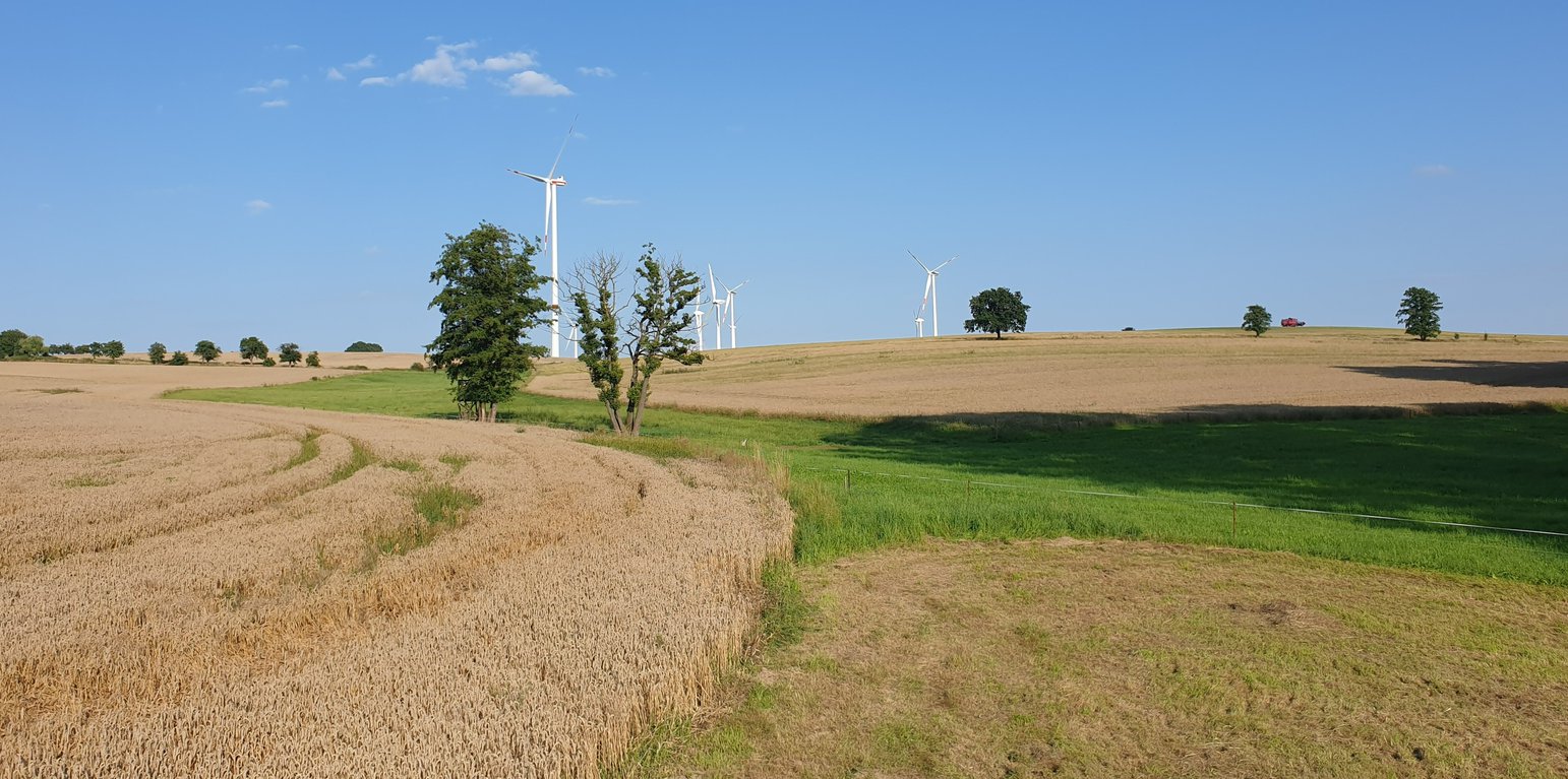
Example of a "grassed waterway" in the catchment area. (Felix Witing)
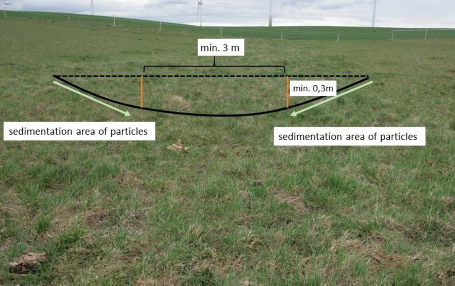
In order to prevent gully erosion along main drainage lines (thalwegs), grassed waterways, composed of grass and other permanent low growing vegetation, are established to discharge water safely. The grassed waterway slows down the surface runoff in the thalweg, increases infiltration and stabilizes the soil surface. This reduces soil erosion by water and the associated runoff of nutrients and pesticides. Fiener et al. (2005) reported a sediment retention of 80-95% and a water retention of 70-90%. Sediment is trapped mainly by water infiltration (infiltration-induced sedimentation) rather than by the filtering effect of vegetation. The conservation value of grassed waterways is not as high as for other measures, but they are still considered as a biotope network as well as a habitat for grassland breeders when extensive management practices are used (LfULG, 2010).
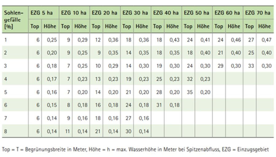
Grassed waterways are typically installed in relatively large arable fields. Normally only the most vulnerable lowest area of the field needs to be grassed. The width of the area to be grassed depends on the size of the drained catchment, the physiographic characteristics of the discharge pathway (channel shape, bottom slope) and the land management (e.g. working width of the agricultural machinery). The United States Department of Agriculture (2020) recommends a total width of the grassed waterway of about 6 m in the upper part and 15 m in the lower part. On average, a grassed waterway should occupy 2% of the catchment area (LfULG, 2015).
During the establishment of the vegetation, it is recommended to protect and stabilize the young plants against strong water flows, by temporary measures such as silt fences or mulching. Once the vegetation is dense enough to withstand heavy rain events, these temporary measures should be removed. After each heavy rainfall event, the waterway should be inspected for damage. Damaged areas should be filled and reseeded, and sediment deposits should be removed.
The choice of the seed mixture depends on the intended use and maintenance of the grassed waterway. A combination of trees and grass increases infiltration rates and natural values. Mowing should be done at least once a year, otherwise, shrubs will establish and suppress the grass. The grassed waterway should not be used as a track for vehicles because of soil compaction, and damage to vegetation. Where possible, tillage should be across the slope – therefore perpendicular to the grassed waterway in order to avoid furrows developing parallel to the waterway. A combination with conservation tillage or other erosion control practices is highly recommended (LfULG, 2010).
Grassed waterways involve a permanent change in land-use, which means a loss of cultivable area, and associated loss of yield - and of income too if it is not covered by subsidies. Many land users dislike such structures in their fields as they impede machinery. Because land users are not always the landowners, they are not always allowed to make permanent changes in land-use. In Germany, a grassland becomes permanent after 5 years. Thus, many farmers decide to plough and replant such grassed areas every 5 years.
The landowner in our documentation had suffered from lodging of his oat crop along the drainage path due to heavy rainfall. Thus, he decided to undesow the oats with ryegrass. In the following year, the undersown ryegrass developed better than the oats and the farmer decided to establish ryegrass as the main crop over the whole field – rather then just in the thalweg, to avoid having to drive around it. Now he mows the area once in the spring for silage and then uses it as pasture for his horses. Every five years, he has to plough the whole area and replant it with ryegrass to prevent it from becoming permanent grassland.
สถานที่: Saxony, เยอรมนี
ตำนวนการวิเคราะห์เทคโนโลยี: พื้นที่เดี่ยว
การเผยแพร่ของเทคโนโลยี: ใช้ ณ จุดที่เฉพาะเจาะจงหรือเน้นไปยังบริเวณพื้นที่ขนาดเล็ก
In a permanently protected area?: ไม่ใช่
วันที่ในการดำเนินการ: 2022; น้อยกว่า 10 ปี (ไม่นานนี้)
ประเภทของการแนะนำ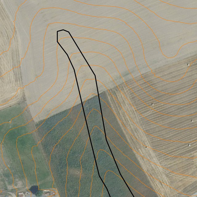


| Species | Count |
| horses | 2 |


| ปัจจัยนำเข้า | หน่วย | ปริมาณ | ค่าใช้จ่ายต่อหน่วย (€) | ค่าใช้จ่ายทั้งหมดต่อปัจจัยนำเข้า (€) | %ของค่าใช้จ่ายที่ก่อให้เกิดขึ้นโดยผู้ใช้ที่ดิน |
| แรงงาน | |||||
| seeding | ha | 1.0 | 20.19 | 20.19 | 100.0 |
| rolling | ha | 1.0 | 19.58 | 19.58 | 100.0 |
| วัสดุด้านพืช | |||||
| seeds | ha | 1.0 | 32.4 | 32.4 | 100.0 |
| ค่าใช้จ่ายทั้งหมดของการจัดตั้งเทคโนโลยี | 72.17 | ||||
| Total costs for establishment of the Technology in USD | 79.31 | ||||
| ปัจจัยนำเข้า | หน่วย | ปริมาณ | ค่าใช้จ่ายต่อหน่วย (€) | ค่าใช้จ่ายทั้งหมดต่อปัจจัยนำเข้า (€) | %ของค่าใช้จ่ายที่ก่อให้เกิดขึ้นโดยผู้ใช้ที่ดิน |
| แรงงาน | |||||
| mulching | ha | 1.0 | 24.87 | 24.87 | 100.0 |
| ploughing | ha | 0.2 | 63.56 | 12.71 | 100.0 |
| reseeding | ha | 0.2 | 39.77 | 7.95 | 100.0 |
| วัสดุด้านพืช | |||||
| seeds | 32,4 | 0.2 | 32.4 | 6.48 | 100.0 |
| ค่าใช้จ่ายทั้งหมดของการบำรุงรักษาสภาพเทคโนโลยี | 52.01 | ||||
| Total costs for maintenance of the Technology in USD | 57.15 | ||||
The loss of arable land (used for forage oats) cannot be compensated by harvesting grass on the runoff path.
Measure does not affect yield, but means a loss of area.
Costs for seeds
If a whole field is converted to a grassed waterway workload decreases. However, for a typical grassed waterway (just greening of the thalweg) an increase in workload can be expected.
Reduction in surface water runoff.
No more soil deposits in the yard/on the street.


