ePrakriti - A workbook for landscape based planning using geo-informatic tools
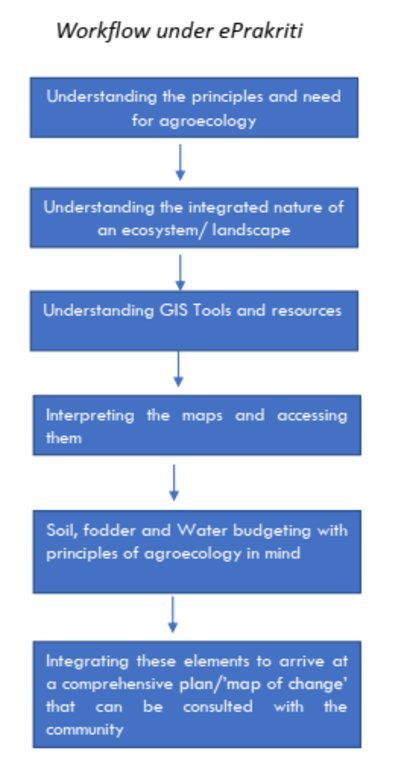
The e-Prakriti approach is a planning method that utilizes GIS tools to integrate ecosystem-based natural farming interventions into agricultural operations. It focuses on creating scientific and efficient planning techniques that consider the landscape as a unit, such as a Village, Block, District and watersheds or river basins. This approach uses open-source datasets, including spatial and non-spatial data, to develop a comprehensive activity plan for natural resource management at a landscape level and having natural farming approaches as its core.
To facilitate the planning process using the various open-source platforms, GIZ has developed a comprehensive guide cum training module under the Pro-Soil Project. This guide comprehensively captures the different open-source platforms and their application to the local context, so to plan and implement natural-farming based interventions. The guide can be used to build the capacity of local-community resource persons, members of local self-governance (Panchayati Raj) institutions and other projects working at the village or cluster level.
The primary purpose of e-Prakriti is to enable effective and efficient management, monitoring, and conservation of natural resources, including sustainable soil management, water management, degraded land reclamation, crop and seed system design, bio-resource and fodder assessment, agro-infrastructure mapping, and the planning of sustainable enterprises. This e-Prakriti approach is used to conduct inventory and management of natural resources, such as forests, wetlands, and wildlife habitats, by mapping the extent and distribution of these resources and tracking their use and status over time. The e-Prakriti approach monitors changes in natural resources, evaluates the effectiveness of conservation measures, and identifies areas that require further intervention. Additionally, e-Prakriti technology can support planning and decision-making related to natural resource management by identifying areas most suitable for conservation or development activities.
Establishing and maintaining an e-Prakriti approach requires data collection on natural resources, effective data management, building capacity among stakeholders, appropriate technology infrastructure and institutional support. The benefits and impacts of the e-Prakriti approach include promoting sustainable development, improving natural resource management, reducing disaster risks, increasing community participation, improving policy and decision-making and conserving biodiversity. Land users' perceptions and experiences of e-Prakriti may vary depending on factors such as socio-economic background, level of education, cultural values and their relationship with natural resources. It is important to consider these factors when designing and implementing e-Prakriti approaches to meet the needs and expectations of land users.
GIZ has collaborated with the State Rural Livelihood Mission of Madhya Pradesh (MP-SRLM) for the practical application of the e-Prakriti approach in the planning process by the local community resource persons. GIZ provides training and operational support to team members for the successful application of e-Prakriti approaches in day-to-day work.
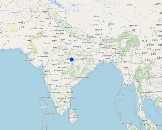
สถานที่: Changariya village, Bichiya block,, Madhya Pradesh, อินเดีย
วันที่ริเริ่ม: n.a.
ปีที่สิ้นสุด: 2023
ประเภทของแนวทาง
| ผู้มีส่วนได้เสียหรือองค์กรที่นำไปปฏิบัติใช้มีส่วนเกี่ยวข้องกับแนวทางนี้อย่างไร | ระบุผู้มีส่วนได้ส่วนเสีย | อธิบายบทบาทของผู้มีส่วนได้ส่วนเสีย |
| ผู้ใช้ที่ดินระดับท้องถิ่นหรือชุมชนระดับท้องถิ่น | Local community members, farmers | They have provided the data and information during the ground proofing exercises |
| องค์กรที่ขึ้นอยู่กับชุมชน | Local Community - Participation of local groups in implementing the program activities. Community representatives from villages - support/drive the program's activities. | Community consultations are critical in promoting sustainable development interventions. It is vital to adequately prepare the community for the actions required, and community representatives must be involved at all planning levels, starting from the ground level. The principles of inclusivity and cooperation are crucial in building trust and promoting effective collaboration among community members. The community's input is essential in creating a suitable action plan and developing maps at the beginning and end of the planning process through larger community consultations. By involving the community in this way, the intervention is more likely to be successful, sustainable and aligned with the community's needs and aspirations. This approach ensures that the community is adequately prepared to undertake the required actions and the intervention is more likely to have a positive impact on the community's well-being in the long run. |
| ผู้เชี่ยวชาญ SLM หรือที่ปรึกษาการเกษตร | 1. Team from GIZ and consultants who developed the e-Prakriti module 2. Specialist from project implementing team | SLM specialists from GIZ, from the implementing agency, other consultants from the domain of GIS and satellite-based applications have developed the e-Prakriti module. They have looked into the specific requirements for planning the natural farming interventions and available open source platforms to meet that requirement. Once this is developed they also did some ground truthing exercises in the field to observe the accuracy of collected data along with application in the field. |
| ครู เด็กนักเรียน หรือนักศึกษา | Local Community Representative (Community Resource Person) | The CRP is trained to use the E-Prakriti tools for planning natural farming practices. He/she engages with village groups and the program team for planning, implementation and execution. They are considered the most important stakeholders in the process as it is expected that CRPs will use this tool in the planning of their activities. |
| องค์กรพัฒนาเอกชน | Foundation for Ecological Security (FES) NGO | FES is involved in piloting the approach in villages, handholding for the implementation and monitoring the work. Scaling up plans with different agencies is undertaken once the piloting is successful and evidence is generated. |
| รัฐบาลระดับท้องถิ่น | Gram Panchayat (village self governing body) Liaison with different government departments concerned viz. Departments like Water Resource, NREGS, Animal Husbandry, Agriculture, Horticulture, Panchayat etc. | Convergence planning is crucial for the successful implementation of natural farming as it extensively relies on the utilization of common natural resources. This can only be achieved through the integrated effort of various concerned Departments, such as Water Resources, NREGS, Animal Husbandry, Agriculture, Horticulture, Panchayat, etc. Therefore, it is essential to hold joint consultations with these departments to ensure that everyone is on the same page and has a shared understanding of the objectives and strategies for natural farming. These consultations can help to identify the potential areas of collaboration and the specific roles and responsibilities of each department in the implementation of natural farming practices. In addition to engaging with the relevant departments, it is equally important to involve the district administration in the planning process. The District Collector, CEO of Zila, and Block Panchayat can play a facilitative role in bringing together the various departments and stakeholders involved in natural farming, promoting collaboration and convergence among them. Through effective convergence planning, it is possible to achieve better coordination and utilization of resources, resulting in improved outcomes for natural farming. This will also contribute to the sustainable development of rural communities and the conservation of natural resources in the long run. |
| องค์การระหว่างประเทศ | Deutsche Gesellschaft für Internationale Zusammenarbeit (GIZ) GmbH | Collated the experiences and prepared the workbook that gives an overview of planning for natural farming using open-source data |
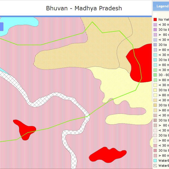
In order to effectively plan for natural farming using GIS tools, it is important to involve the larger systems around the community and the community itself. The first step is to identify and define a unit of intervention, such as a village. Open-source satellite data can then be used to understand and estimate various factors such as geomorphology and geohydrology. This data can be complemented with other available data from sources such as the Ground Water Board or the NREGS portal.
Using QGIS tool, the various data sets can be superimposed to find relationships between them. On-ground validation (truthing) of the GIS data is also necessary to ensure its accuracy. Once the data sets are gathered, an extensive interpretation from maps is undertaken, and the data is translated into easily understandable and implementable material for the community.
Community consultations are a critical part of the intervention, with community representatives being involved at all levels of planning. Inclusivity and cooperation are key principles in engaging the community and government departments and institutions for the judicious use of common resources. Larger community consultations are held at the beginning and end of the planning process to arrive at a suitable action plan using the prepared maps.
The planned actions and locations are plotted on maps on Google Earth, and convergence planning is necessary for the integrated efforts of several concerned departments. Joint consultations are held with these departments, and the district administration can play a facilitative role in bringing everyone on the same page. Lastly, it is important to train departmental engineers, Rozgar Sahayaks, and other technically competent functionaries in basic GIS-based software such as Bhuvan, QGIS, India-WRIS, and Bhuvan Panchayat to extract necessary data.
การตัดสินใจถูกทำโดย
การตัดสินใจถูกตัดสินอยู่บนพื้นฐานของ
1 Village boundaries
2 Village Assets and Infrastructure
3 Watershed / Sub-basin Map
4 Natural Drainage line
8 Availability of groundwater
5 Further resources on Water
5 Geomorphology
6 Slopes within the topography
7 Lineaments- cracks in the land for the generation of aquifiers
8 Soil Erosion
10 Soil kinds/data
11 Land usage pattern
12 Crop season land
13 Wastelands Map
Training and handholding of stakeholders
The targeted areas that specifically needed conservation work were focused on
This has been the most important purpose of this approach. The use of various spatial tools ensured evidence-based decision-making
The approach may be a great tool for effective and efficient natural farming-based practices and other SLM technologies
Yes. It has been of great use
Developing projects using the technology has ensured effective financial planning for the planned interventions
Land users and local community resource persons learned about the various tools and technologies available for scientific planning
Community resource persons
Stakeholders like farmers, FPOs, local community resource persons, NGOs, Government institutions all are in a position to apply a coordinated approach by using this tool
Better mapping of resources could mitigate some conflicts among the community members
The promotion of natural farming empowers women members as they are core to it. Families get an access to safe and healthy foods as well.
The approach developed is a guidebook, which can be used by anyone using the available open-access platform which is free to use


