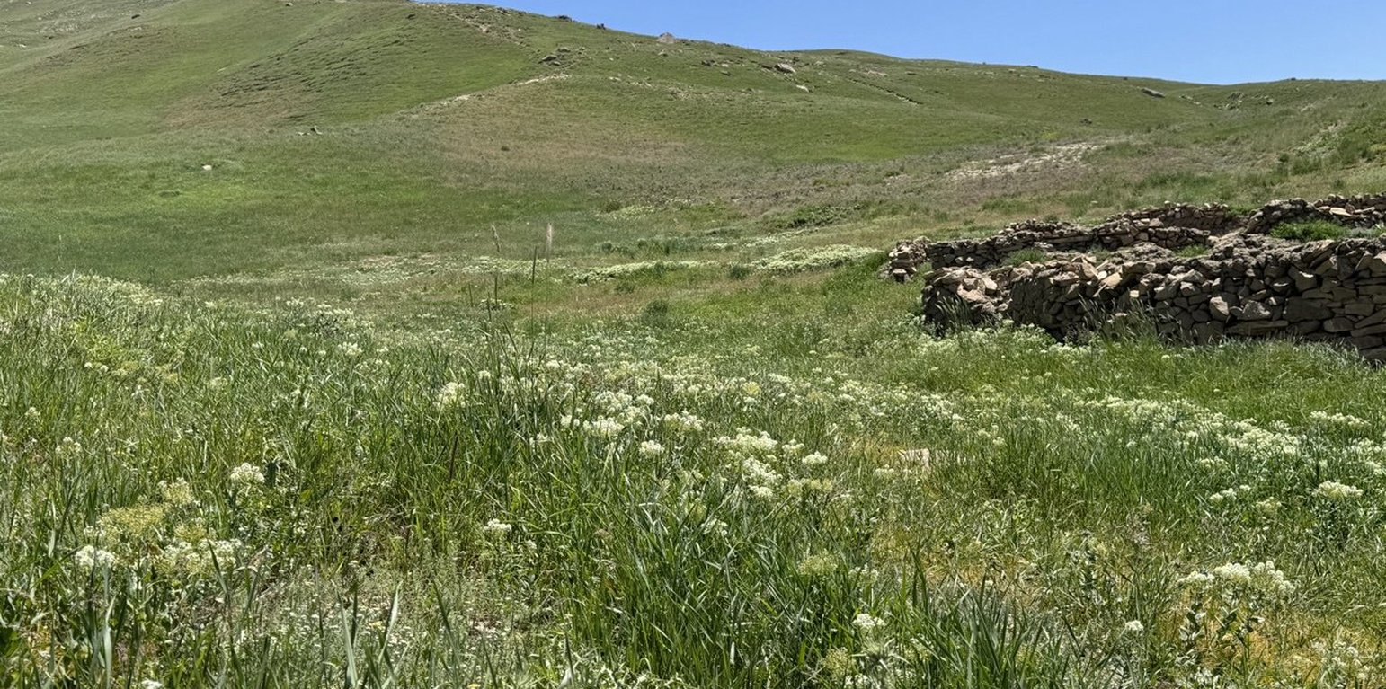
Rangeland after three years of quarantine in Deh Beranj Rangeland Management Association of Qadis district, Badghis, Afghanistan (Shamsulhaq Shams)

Implementing Site Quarantine to reduce rangeland degradation in the highlands of Badghis (อัฟกานิสถาน)

قرنطینه و مدیریت چرا در ارتفاعات بادغیس برای کاهش تخریب مراتع

คำอธิบาย

Restoring degraded rangelands through quarantine in Qadis district, Badghis Afghanistan.

The project “Community-based sustainable land and forest management in Afghanistan”, implemented by FAO with the financial support of GEF, aimed to promote biodiversity conservation, climate change mitigation, and rangeland productivity through introducing community-based sustainable land and forest management (SLM/SFM) practices in rangeland and forest areas within five targeted provinces, including Badghis, that benefited rural communities that rely on these ecosystems for their livelihood.

In June 2022, a 1,000-hectare rangeland quarantine area was established to promote the rehabilitation of degraded land and restore the natural vegetation cover. This area was strategically enclosed with clearly marked benchmark boundaries to prevent grazing and ensure its complete protection. By protecting this area from human interference and grazing, the land has been given the opportunity to recover naturally.

The quarantine area has shown remarkable improvements in the health of its ecosystem. Native grasses, shrubs, and bushes have successfully rehabilitated, with noticeable growth and regeneration. The efforts to protect this area have allowed these plants to thrive without the pressure of overgrazing, leading to the revitalization of the local flora.

A significant outcome of the quarantine area is its role as a natural seed bank. Native seeds collected from this rehabilitated land are now being stored and used for reseeding other degraded rangelands. These seeds, adapted to the local environment, have high potential for successful regeneration when used to restore other areas facing similar ecological challenges. This process not only supports the rehabilitation of nearby rangelands but also contributes to the long-term sustainability and resilience of the local ecosystem.

The success of this quarantine area highlights the importance of protective measures and demonstrates the potential for land recovery through strategic interventions. As a result, this area serves as a model for rangeland rehabilitation. The lessons from the technology applied can be a valuable resource for future restoration efforts across the region.
สถานที่

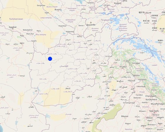
สถานที่: Deh Beranj Rangeland Management Association, Qadis district, Badghis province, อัฟกานิสถาน

ตำนวนการวิเคราะห์เทคโนโลยี: พื้นที่เดี่ยว

ตำแหน่งทางภูมิศาสตร์ของสถานที่ที่ถูกเลือ
  • 63.35644, 34.74008

การเผยแพร่ของเทคโนโลยี: กระจายไปอย่างสม่ำเสมอในพื้นที่ (10.0 km²)

In a permanently protected area?: ไม่ใช่

วันที่ในการดำเนินการ: 2022

ประเภทของการแนะนำ
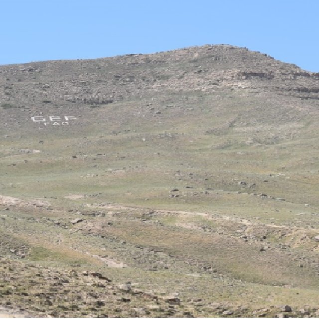
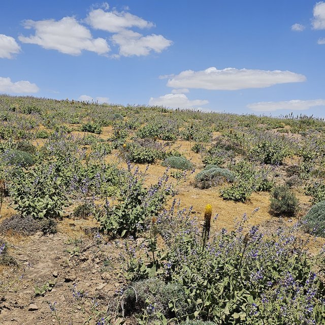
Before implementation of quarantine technology (Safiullah Mohammadi)
Regenerated rangeland after implementation of the quarantine technology (Safiullah Mohammadi)

การจำแนกประเภทเทคโนโลยี

จุดประสงค์หลัก
  • ปรับปรุงการผลิตให้ดีขึ้น
  • ลด ป้องกัน ฟื้นฟู การเสื่อมโทรมของที่ดิน
  • อนุรักษ์ระบบนิเวศน์
  • ป้องกันพื้นที่ลุ่มน้ำ/บริเวณท้ายน้ำ โดยร่วมกับเทคโนโลยีอื่นๆ
  • รักษาสภาพหรือปรับปรุงความหลากหลายทางชีวภาพ
  • ลดความเสี่ยงของภัยพิบัติ
  • ปรับตัวเข้ากับการเปลี่ยนแปลงภูมิอากาศของโลก สภาพภูมิอากาศที่รุนแรงและผลกระทบ
  • ชะลอการเปลี่ยนแปลงภูมิอากาศของโลกและผลกระทบ
  • สร้างผลกระทบทางด้านเศรษฐกิจที่เป็นประโยชน์
  • สร้างผลกระทบทางด้านสังคมที่เป็นประโยชน์
การใช้ที่ดิน
Land use mixed within the same land unit: ไม่ใช่

  • ทุ่งหญ้าเลี้ยงสัตว์
    • กึ่งโนแมนดิซึ่มหรือแพสโตแรลลิซึ่ม (Semi-nomadism/pastoralism)
    • ทุ่งหญ้าเลี้ยงสัตว์ที่ได้มีการปรับปรุง (Improved pastures)
    Animal type: sheep
    Is integrated crop-livestock management practiced? ไม่ใช่
    ผลิตภัณฑ์และบริการ: meat, milk
      SpeciesCount
      sheep50000
    การใช้น้ำ
    • จากน้ำฝน
    • น้ำฝนร่วมกับการชลประทาน
    • การชลประทานแบบเต็มรูปแบบ

    ความมุ่งหมายที่เกี่ยวข้องกับการเสื่อมโทรมของที่ดิน
    • ป้องกันความเสื่อมโทรมของที่ดิน
    • ลดความเสื่อมโทรมของดิน
    • ฟื้นฟูบำบัดที่ดินที่เสื่อมโทรมลงอย่างมาก
    • ปรับตัวกับสภาพความเสื่อมโทรมของที่ดิน
    • ไม่สามารถใช้ได้
    ที่อยู่ของการเสื่อมโทรม
    • การกัดกร่อนของดินโดยน้ำ - Wt (Loss of topsoil): การสูญเสียดินชั้นบนหรือการกัดกร่อนที่ผิวดิน
    • การเสื่อมโทรมของดินทางด้านกายภาพ - Pw (Waterlogging): ภาวะชุ่มน้ำ
    • การเสื่อมโทรมของดินทางด้านชีวภาพ - Bc (Reduction of vegetation cover): การลดลงของจำนวนพืชที่ปกคลุมดิน , Bf (Detrimenta leffects of fires): ผลเสียหายจากไฟ, Bs (Quality and species composition): องค์ประกอบหรือความหลากหลายทางคุณภาพและชนิดพันธุ์ลดลง
    กลุ่ม SLM
    • การปิดล้อมพื้นที่ (หยุดการใช้ประโยชน์ สนับสนุนการฟื้นฟู)
    • การจัดการปศุสัตว์และทุ่งหญ้าเลี้ยงสัตว์
    • การปรับปรุงดิน / พืชคลุมดิน
    มาตรการ SLM
    • มาตรการอนุรักษ์ด้วยวิธีพืช - V1: ต้นไม้และพุ่มไม้คลุมดิน
    • มาตรการอนุรักษ์ด้วยการจัดการ - M5: การควบคุมหรือการเปลี่ยนแปลงขององค์ประกอบของชนิดพันธุ์, M6: การจัดการของเสีย (การทำ รีไซเคิล การเอากลับมาใช้ใหม่หรือการลดปริมาณ)

    แบบแปลนทางเทคนิค

    ข้อมูลจำเพาะด้านเทคนิค
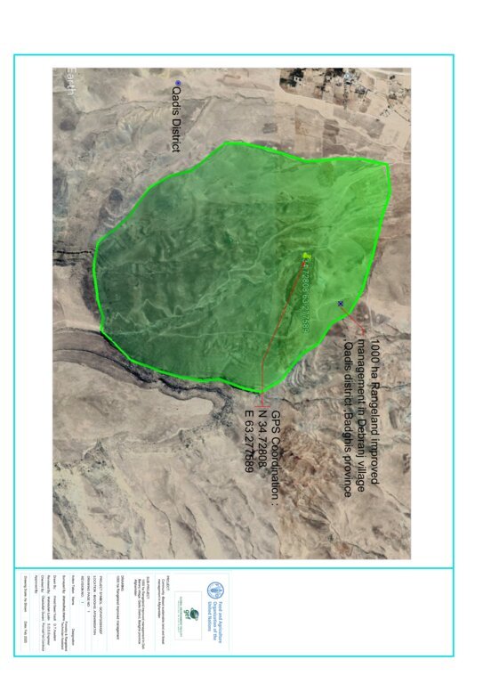
    • Green area indicates where grasses regenerated and the GPS shows exact quarantined area.
    • Rangeland quarantine was implemented for three years to facilitate the recovery of grasses. By restricting access to degraded areas, we allowed native vegetation to regenerate without disturbance. The grazing exclusion is by social fencing.
    • The boundary mark is not a fence but functions as one. Constructed from rocks (1 x 1.5 x 2 meters), the boundary marks are placed every 100 to 200 meters around the rangeland quarantine area to clearly mark its boundaries and prevent or control grazing, ensuring the area remains closed for its recovery.
    • Stakeholder involvement through inclusion of local communities in planning and implementation processes.
    Author: Shamsulhaq Shams

    การจัดตั้งและการบำรุงรักษา: กิจกรรม ปัจจัยและค่าใช้จ่าย

    การคำนวนต้นทุนและค่าใช้จ่าย
    • ค่าใช้จ่ายถูกคำนวน ต่อพื้นที่ที่ใช้เทคโนโลยี (หน่วยของขนาดและพื้นที่: 1000 Ha)
    • สกุลเงินที่ใช้คำนวณค่าใช้จ่าย USD
    • อัตราแลกเปลี่ยน (ไปเป็นดอลลาร์สหรัฐ) คือ 1 ดอลลาร์สหรัฐ = ไม่มีคำตอบ
    • ค่าจ้างเฉลี่ยในการจ้างแรงงานต่อวันคือ 5 USD
    ปัจจัยที่สำคัญที่สุดที่มีผลต่อค่าใช้จ่าย
    Skilled and unskilled labour
    กิจกรรมเพื่อการจัดตั้ง
    1. Survey and site selection followed by feasibility study (ช่วงระยะเวลา/ความถี่: 1st month 10/04/2022)
    2. Preparing construction material (eg. assembling rocks) (ช่วงระยะเวลา/ความถี่: 2nd month 08/05/2022)
    3. Construction of boundary marks around the area (ช่วงระยะเวลา/ความถี่: 3rd month 01/06/2022)
    4. Capacity building of the target communities (ช่วงระยะเวลา/ความถี่: 4th month 05/07/2022)
    5. Hiring guard for patrolling the area (ช่วงระยะเวลา/ความถี่: 5th month 01/08/2022)
    ปัจจัยและค่าใช้จ่ายของการจัดตั้ง (per 1000 Ha)
    ปัจจัยนำเข้า หน่วย ปริมาณ ค่าใช้จ่ายต่อหน่วย (USD) ค่าใช้จ่ายทั้งหมดต่อปัจจัยนำเข้า (USD) %ของค่าใช้จ่ายที่ก่อให้เกิดขึ้นโดยผู้ใช้ที่ดิน
    แรงงาน
    Skilled labour for construction of boundary mark person/day 60.0 11.0 660.0 100.0
    Unskilled labour for construction of boundary mark person/day 130.0 5.0 650.0 100.0
    Guard for patrolling the area person/day 2.0 1015.0 2030.0 50.0
    วัสดุสำหรับก่อสร้าง
    Rock M3 100.0 1.41 141.0 100.0
    ค่าใช้จ่ายทั้งหมดของการจัดตั้งเทคโนโลยี 3'481.0
    Total costs for establishment of the Technology in USD 3'481.0
    กิจกรรมสำหรับการบำรุงรักษา
    1. Patrolling the area (ช่วงระยะเวลา/ความถี่: All seasons/regular)
    ปัจจัยและค่าใช้จ่ายของการบำรุงรักษา (per 1000 Ha)
    ปัจจัยนำเข้า หน่วย ปริมาณ ค่าใช้จ่ายต่อหน่วย (USD) ค่าใช้จ่ายทั้งหมดต่อปัจจัยนำเข้า (USD) %ของค่าใช้จ่ายที่ก่อให้เกิดขึ้นโดยผู้ใช้ที่ดิน
    แรงงาน
    Guard for patrolling the area (second year) person/year 2.0 1015.0 2030.0 50.0
    ค่าใช้จ่ายทั้งหมดของการบำรุงรักษาสภาพเทคโนโลยี 2'030.0
    Total costs for maintenance of the Technology in USD 2'030.0

    สิ่งแวดล้อมทางธรรมชาติ

    ปริมาณน้ำฝนเฉลี่ยรายปี
    • < 250 ม.ม.
    • 251-500 ม.ม.
    • 501-750 ม.ม.
    • 751-1,000 ม.ม.
    • 1,001-1,500 ม.ม.
    • 1,501-2,000 ม.ม.
    • 2,001-3,000 ม.ม.
    • 3,001-4,000 ม.ม.
    • > 4,000 ม.ม.
    เขตภูมิอากาศเกษตร
    • ชื้น
    • กึ่งชุ่มชื้น
    • กึ่งแห้งแล้ง
    • แห้งแล้ง
    ข้อมูลจำเพาะเรื่องภูมิอากาศ
    ปริมาณเฉลี่ยฝนรายปีในหน่วยมม. 250.0
    Winter (January, February, March)
    Dry periods start from May till November
    Annual temperature is 25 degrees
    ความชัน
    • ราบเรียบ (0-2%)
    • ลาดที่ไม่ชัน (3-5%)
    • ปานกลาง (6-10%)
    • เป็นลูกคลื่น (11-15%)
    • เป็นเนิน (16-30%)
    • ชัน (31-60%)
    • ชันมาก (>60%)
    ภูมิลักษณ์
    • ที่ราบสูง/ที่ราบ
    • สันเขา
    • ไหล่เขา
    • ไหล่เนินเขา
    • ตีนเนิน
    • หุบเขา
    ความสูง
    • 0-100 เมตร
    • 101-500 เมตร
    • 501-1,000 เมตร
    • 1,001-1,500 เมตร
    • 1,501-2,000 เมตร
    • 2,001-2,500 เมตร
    • 2,501-3,000 เมตร
    • 3,001-4,000 เมตร
    • > 4,000 เมตร
    เทคโนโลยีถูกประยุกต์ใช้ใน
    • บริเวณสันเขา (convex situations)
    • บริเวณแอ่งบนที่ราบ (concave situations)
    • ไม่เกี่ยวข้อง
    ความลึกของดิน
    • ตื้นมาก (0-20 ซ.ม.)
    • ตื้น (21-50 ซ.ม.)
    • ลึกปานกลาง (51-80 ซ.ม.)
    • ลึก (81-120 ซ.ม.)
    • ลึกมาก (>120 ซ.ม.)
    เนื้อดิน (ดินชั้นบน)
    • หยาบ/เบา (ดินทราย)
    • ปานกลาง (ดินร่วน ทรายแป้ง)
    • ละเอียด/หนัก (ดินเหนียว)
    เนื้อดิน (> 20 ซม. ต่ำกว่าพื้นผิว)
    • หยาบ/เบา (ดินทราย)
    • ปานกลาง (ดินร่วน ทรายแป้ง)
    • ละเอียด/หนัก (ดินเหนียว)
    สารอินทรียวัตถุในดิน
    • สูง (>3%)
    • ปานกลาง (1-3%)
    • ต่ำ (<1%)
    น้ำบาดาล
    • ที่ผิวดิน
    • <5 เมตร
    • 5-50 เมตร
    • > 50 เมตร
    ระดับน้ำบาดาลที่ผิวดิน
    • เกินพอ
    • ดี
    • ปานกลาง
    • ไม่ดีหรือไม่มีเลย
    คุณภาพน้ำ (ยังไม่ได้รับการบำบัด)
    • เป็นน้ำเพื่อการดื่มที่ดี
    • เป็นน้ำเพื่อการดื่มที่ไม่ดี (จำเป็นต้องได้รับการบำบัด)
    • เป็นน้ำใช้เพื่อการเกษตรเท่านั้น (การชลประทาน)
    • ใช้ประโยชน์ไม่ได้
    Water quality refers to: both ground and surface water
    ความเค็มของน้ำเป็นปัญหาหรือไม่?
    • ใช่
    • ไม่ใช่

    การเกิดน้ำท่วม
    • ใช่
    • ไม่ใช่
    ความหลากหลายทางชนิดพันธุ์
    • สูง
    • ปานกลาง
    • ต่ำ
    ความหลากหลายของแหล่งที่อยู่
    • สูง
    • ปานกลาง
    • ต่ำ

    ลักษณะเฉพาะของผู้ใช้ที่ดินที่ประยุกต์ใช้เทคโนโลยี

    เป้าหมายทางการตลาด
    • เพื่อการยังชีพ (หาเลี้ยงตนเอง)
    • mixed (subsistence/ commercial)
    • ทำการค้า/การตลาด
    รายได้จากภายนอกฟาร์ม
    • < 10% ของรายได้ทั้งหมด
    • 10-50% ของรายได้ทั้งหมด
    • > 50% ของรายได้ทั้งหมด
    ระดับของความมั่งคั่งโดยเปรียบเทียบ
    • ยากจนมาก
    • จน
    • พอมีพอกิน
    • รวย
    • รวยมาก
    ระดับของการใช้เครื่องจักรกล
    • งานที่ใช้แรงกาย
    • การใช้กำลังจากสัตว์
    • การใช้เครื่องจักรหรือเครื่องยนต์
    อยู่กับที่หรือเร่ร่อน
    • อยู่กับที่
    • กึ่งเร่ร่อน
    • เร่ร่อน
    เป็นรายบุคคลหรือกลุ่ม
    • เป็นรายบุคคล/ครัวเรือน
    • กลุ่ม/ชุมชน
    • สหกรณ์
    • ลูกจ้าง (บริษัท รัฐบาล)
    เพศ
    • หญิง
    • ชาย
    อายุ
    • เด็ก
    • ผู้เยาว์
    • วัยกลางคน
    • ผู้สูงอายุ
    พื้นที่ที่ใช้ต่อครัวเรือน
    • < 0.5 เฮกตาร์
    • 0.5-1 เฮกตาร์
    • 1-2 เฮกตาร์
    • 2-5 เฮกตาร์
    • 5-15 เฮกตาร์
    • 15-50 เฮกตาร์
    • 50-100 เฮกตาร์
    • 100-500 เฮกตาร์
    • 500-1,000 เฮกตาร์
    • 1,000-10,000 เฮกตาร์
    • >10,000 เฮกตาร์
    ขนาด
    • ขนาดเล็ก
    • ขนาดกลาง
    • ขนาดใหญ่
    กรรมสิทธิ์ในที่ดิน
    • รัฐ
    • บริษัท
    • เป็นแบบชุมชนหรือหมู่บ้าน
    • กลุ่ม
    • รายบุคคล ไม่ได้รับสิทธิครอบครอง
    • รายบุคคล ได้รับสิทธิครอบครอง
    สิทธิในการใช้ที่ดิน
    • เข้าถึงได้แบบเปิด (ไม่ได้จัดระเบียบ)
    • เกี่ยวกับชุมชน (ถูกจัดระเบียบ)
    • เช่า
    • รายบุคคล
    สิทธิในการใช้น้ำ
    • เข้าถึงได้แบบเปิด (ไม่ได้จัดระเบียบ)
    • เกี่ยวกับชุมชน (ถูกจัดระเบียบ)
    • เช่า
    • รายบุคคล
    เข้าถึงการบริการและโครงสร้างพื้นฐาน
    สุขภาพ

    จน
    x
    ดี
    การศึกษา

    จน
    x
    ดี
    ความช่วยเหลือทางด้านเทคนิค

    จน
    x
    ดี
    การจ้างงาน (เช่น ภายนอกฟาร์ม)

    จน
    x
    ดี
    ตลาด

    จน
    x
    ดี
    พลังงาน

    จน
    x
    ดี
    ถนนและการขนส่ง

    จน
    x
    ดี
    น้ำดื่มและการสุขาภิบาล

    จน
    x
    ดี
    บริการด้านการเงิน

    จน
    x
    ดี

    ผลกระทบ

    ผลกระทบทางด้านเศรษฐกิจและสังคม
    การผลิตพืชที่ใช้เลี้ยงปศุสัตว์
    ลดลง
    x
    เพิ่มขึ้น

    จำนวนก่อน SLM: 500 kg fodder/ hectare
    หลังจาก SLM: 900 kg fodder/hectare
    Preventing overgrazing helps maintain plant cover and allows for recovery periods, leading to increased biomass production.

    การผลิตสัตว์
    ลดลง
    x
    เพิ่มขึ้น

    จำนวนก่อน SLM: 0.5 liter per sheep/day
    หลังจาก SLM: 1 liter per sheep/day
    Enhancing the quality and availability of forage provid sheep with a more nutritious diet, which directly impacts milk production.

    คุณภาพน้ำดื่ม
    ลดลง
    x
    เพิ่มขึ้น

    จำนวนก่อน SLM: Contaminated water with minerals
    หลังจาก SLM: Leading to clearer and cleaner water
    Effective rangeland management practices enhance the overall health of the ecosystem, leading to improved drinking water quality through better infiltration due to better soil cover and less water runoff.

    ผลกระทบด้านสังคมและวัฒนธรรม
    ความมั่นคงด้านอาหาร / พึ่งตนเองได้
    ลดลง
    x
    ปรับปรุงดีขึ้น


    Sustainable rangeland management supports local economies by providing livelihoods through livestock production, which can improve food access and self-sufficiency in communities.

    สถานการณ์ด้านสุขภาพ
    แย่ลง
    x
    ปรับปรุงดีขึ้น

    จำนวนก่อน SLM: Less nutritious animal products
    หลังจาก SLM: More nutritious animal products
    Enhanced forage quality leads to healthier livestock, which provides better quality meat and dairy products, contributing to improved nutrition for communities.

    SLM หรือความรู้เรื่องความเสื่อมโทรมของที่ดิน
    ลดลง
    x
    ปรับปรุงดีขึ้น

    จำนวนก่อน SLM: Little capacity building
    หลังจาก SLM: Capacity building for 500 members of the Rangeland Management Association
    Training programs for farmers and land managers, increasing their knowledge about sustainable practices and land conservation techniques.

    ผลกระทบด้านนิเวศวิทยา
    น้ำไหลบ่าที่ผิวดิน
    เพิ่มขึ้น
    x
    ลดลง


    Rangeland improvement practices can significantly reduce surface runoff, enhance soil health, and improve water quality

    การระบายน้ำส่วนเกิน
    ลดลง
    x
    ปรับปรุงดีขึ้น


    More efficient excess water drainage, enhancing soil structure, reducing waterlogging, and promoting overall ecological health.

    สิ่งปกคลุมดิน
    ลดลง
    x
    ปรับปรุงดีขึ้น

    จำนวนก่อน SLM: 20% soil cover
    หลังจาก SLM: 80-90% soil cover
    Enhanced soil cover leads to healthier ecosystems, improved soil conditions, and increased biodiversity.

    การปกคลุมด้วยพืช
    ลดลง
    x
    เพิ่มขึ้น

    จำนวนก่อน SLM: 20%
    หลังจาก SLM: 80-90%
    Enhanced vegetation cover leads to healthier ecosystems, improved soil conditions, and increased biodiversity

    มวลชีวภาพ/เหนือดินชั้น C
    ลดลง
    x
    เพิ่มขึ้น

    จำนวนก่อน SLM: 20-30% biomass
    หลังจาก SLM: 80-90% biomass
    Rangeland improvement practices significantly boost biomass and above-ground carbon levels, enhancing ecosystem productivity and contributing to carbon sequestration efforts.

    ความหลากหลายทางชีวภาพของพืช
    ลดลง
    x
    เพิ่มขึ้น

    จำนวนก่อน SLM: 60/plants per square meter
    หลังจาก SLM: 200/plants per square meter
    Enhanced plant diversity leads to healthier ecosystems, increased resilience, and improved overall productivity.

    ผลกระทบจากภัยแล้ง
    เพิ่มขึ้น
    x
    ลดลง

    จำนวนก่อน SLM: 500 kg fodder/ha
    หลังจาก SLM: 800 kg fodder/ ha
    Rangeland improvement practices significantly mitigate the impacts of drought, enhancing soil moisture retention, vegetation resilience by enhancing the land's ability to retain moisture and support vegetation growth, and overall ecosystem stability.

    การปล่อยคาร์บอนและก๊าซเรือนกระจก
    เพิ่มขึ้น
    x
    ลดลง

    จำนวนก่อน SLM: 80000 m3/ winter season
    หลังจาก SLM: 20000 m3/ winter season
    Healthy, diverse plant communities capture and sequester more carbon dioxide through photosynthesis, contributing to greater carbon sequestration and contributing to climate change mitigation efforts.

    ผลกระทบนอกพื้นที่ดำเนินการ
    น้ำท่วมพื้นที่ท้ายน้ำ (ที่ไม่เป็นที่ต้องการ)
    เพิ่มขึ้น
    x
    ลดลง

    จำนวนก่อน SLM: 10-12 times /year
    หลังจาก SLM: Zero floods per year
    Risk and impact of downstream flooding is significantly reduced by enhancing vegetation cover, improving soil health, and promoting better water management.

    ผลกระทบของก๊าซเรือนกระจก
    เพิ่มขึ้น
    x
    ลดลง

    จำนวนก่อน SLM: 20 tons CO2 removed/year
    หลังจาก SLM: 50 tons CO2 removed/year
    Healthy rangelands help absorb more carbon in plants and soil, which lowers the amount of CO₂ in the atmosphere. When these lands are grazed properly, they allow perennial and annual grasses to regrow. This regrowth not only captures more carbon but also improves soil health.

    รายได้และค่าใช้จ่าย

    ผลประโยชน์ที่ได้รับเปรียบเทียบกับค่าใช้จ่าย
    ผลตอบแทนระยะสั้น
    ด้านลบอย่างมาก
    x
    ด้านบวกอย่างมาก

    ผลตอบแทนระยะยาว
    ด้านลบอย่างมาก
    x
    ด้านบวกอย่างมาก

    ผลประโยชน์ที่ได้รับเปรียบเทียบกับค่าใช้จ่ายในการบำรุงรักษา
    ผลตอบแทนระยะสั้น
    ด้านลบอย่างมาก
    x
    ด้านบวกอย่างมาก

    ผลตอบแทนระยะยาว
    ด้านลบอย่างมาก
    x
    ด้านบวกอย่างมาก

    Improved rangelands often lead to higher forage yields, supporting larger and healthier livestock populations. This can result in increased income for land users.

    การเปลี่ยนแปลงของสภาพภูมิอากาศ

    การเปลี่ยนแปลงสภาพภูมิอากาศที่ค่อยเป็นค่อยไป
    อุณหภูมิประจำปี ลดลง

    ไม่ดี
    x
    ดีมาก
    ฝนประจำปี เพิ่มขึ้น

    ไม่ดี
    x
    ดีมาก
    สภาพรุนแรงของภูมิอากาศ (ภัยพิบัติ)
    พายุลมประจำท้องถิ่น

    ไม่ดี
    x
    ดีมาก
    คลื่นความร้อน

    ไม่ดี
    x
    ดีมาก
    ภัยจากฝนแล้ง

    ไม่ดี
    x
    ดีมาก
    น้ำท่วมฉับพลัน

    ไม่ดี
    x
    ดีมาก

    การน้อมเอาความรู้และการปรับใช้

    เปอร์เซ็นต์ของผู้ใช้ที่ดินในพื้นที่ที่นำเทคโนโลยีไปใช้
    • ครั้งเดียวหรือเป็นการทดลอง
    • 1-10%
    • 11-50%
    • > 50%
    จากทั้งหมดที่ได้รับเทคโนโลยีเข้ามามีจำนวนเท่าใดที่ทำแบบทันที โดยไม่ได้รับการจูงใจด้านวัสดุหรือการเงินใดๆ?
    • 0-10%
    • 11-50%
    • 51-90%
    • 91-100%
    เทคโนโลยีได้รับการปรับเปลี่ยนเร็วๆ นี้เพื่อให้ปรับตัวเข้ากับสภาพที่กำลังเปลี่ยนแปลงหรือไม่?
    • ใช่
    • ไม่ใช่
    สภาพที่กำลังเปลี่ยนแปลงอันไหน?
    • การเปลี่ยนแปลงแบบค่อยเป็นค่อยไปและสภาพรุนแรงของภูมิอากาศ
    • การเปลี่ยนแปลงของตลาด
    • การมีแรงงานไว้ให้ใช้ (เนื่องจากการอพยพย้ายถิ่นฐาน)

    บทสรุปหรือบทเรียนที่ได้รับ

    จุดแข็ง: มุมมองของผู้ใช้ที่ดิน
    • Rangeland quarantine allow for better management of pasture resources leading to improved pasture and grass quality.
    • Rangeland quarantine increased productivity can maximize the land's carrying capacity leading to higher livestock productivity per unit area.
    • Rangeland quarantine helps prevent overgrazing, reduces parasite loads, minimizes soil compaction, and allows for more natural feeding behaviors, all of which contribute to overall animal health.
    • Reduce greenhouse gas emissions through carbon sequestration.
    • Properly managed rangeland quarantine can promote biodiversity by creating varied habitats and supporting a range of plant and animal species.
    • Implementing rangeland quarantine can lead to knowledge transfer among farmers, researchers, and agricultural extension services, fostering innovation and best practices in sustainable land management.
    จุดแข็ง: ทัศนคติของผู้รวบรวมหรือวิทยากรคนอื่นๆ
    จุดด้อย/ข้อเสีย/ความเสี่ยง: มุมมองของผู้ใช้ที่ดินแก้ไขปัญหาได้อย่างไร
    • Ensuring the right number of animals on each grazing area can be challenging, leading to risks of overgrazing or underutilization. Stocking rate management.
    • Rangeland quarantine can lead to social conflicts among different user groups, such as conflicting interests between livestock owners, conservationists, and indigenous communities. Facilitating dialogue among stakeholders, promoting collaborative rangeland management approaches, respecting traditional land tenure systems, and fostering community-based conflict resolution mechanisms can help manage.
    จุดด้อย/ข้อเสีย/ความเสี่ยง: ทัศนคติของผู้รวบรวมหรือวิทยากรคนอื่นๆแก้ไขปัญหาได้อย่างไร
    • When grazing animals are quarantined, their numbers may increase in certain areas, leading to overgrazing. This can result in habitat degradation and loss of plant diversity. Implement managed grazing systems to control population densities and prevent overgrazing. This can include rotational grazing practices.

    การอ้างอิง

    ผู้รวบรวม
    • Shamsulhaq Shams
    Editors
    • Mir Wali Khan Lakanwal
    • Mohammad Mustafa Sahebzada
    • Obaidullah Durani
    • Megha bajaj
    ผู้ตรวจสอบ
    • Rima Mekdaschi Studer
    • Illias Animon
    • Muhammad Ishaq Safi
    วันที่จัดทำเอกสาร: 19 ธันวาคม 2024
    การอัพเดทล่าสุด: 6 พฤษภาคม 2025
    วิทยากร
    คำอธิบายฉบับเต็มในฐานข้อมูล WOCAT
    ข้อมูล SLM ที่ถูกอ้างอิง
    การจัดทำเอกสารถูกทำโดย
    องค์กร โครงการ
    This work is licensed under Creative Commons Attribution-NonCommercial-ShareaAlike 4.0 International