Joint village land use planning [แทนซาเนีย]
- ผู้สร้างสรรค์:
- การอัพเดท:
- ผู้รวบรวม: Fiona Flintan
- ผู้เรียบเรียง: –
- ผู้ตรวจสอบ: Donia Mühlematter, Simone Verzandvoort, Rima Mekdaschi Studer, Joana Eichenberger
approaches_3336 - แทนซาเนีย
ดูส่วนย่อย
ขยายทั้งหมด ย่อทั้งหมด1. ข้อมูลทั่วไป
1.2 รายละเอียดที่ติดต่อได้ของผู้รวบรวมและองค์กรที่เกี่ยวข้องในการประเมินและการจัดเตรียมทำเอกสารของแนวทาง
ชื่อของโครงการซึ่งอำนวยความสะดวกในการทำเอกสารหรือการประเมินแนวทาง (ถ้าเกี่ยวข้อง)
Sustainable Rangeland Management Project (ILC / ILRI)ชื่อของโครงการซึ่งอำนวยความสะดวกในการทำเอกสารหรือการประเมินแนวทาง (ถ้าเกี่ยวข้อง)
Book project: Guidelines to Rangeland Management in Sub-Saharan Africa (Rangeland Management)ชื่อของโครงการซึ่งอำนวยความสะดวกในการทำเอกสารหรือการประเมินแนวทาง (ถ้าเกี่ยวข้อง)
International Livestock Research Institute (ILRI) - เคนยา1.3 เงื่อนไขที่เกี่ยวข้องกับการใช้ข้อมูลที่ได้บันทึกไว้ผ่านทาง WOCAT
วันที่เก็บรวบรวมข้อมูล (ภาคสนาม):
30/11/2016
ผู้รวบรวมและวิทยากรหลักยอมรับเงื่อนไขเกี่ยวกับการใช้ข้อมูลที่ถูกบันทึกผ่านทาง WOCAT:
ใช่
2. คำอธิบายของแนวทาง SLM
2.1 การอธิบายแบบสั้น ๆ ของแนวทาง
Joint village land use planning is a process facilitated by Tanzania's land policy and legislation. It supports the planning, protection and management of shared resources across village boundaries. It is an important tool towards land use planning and better rangeland management. This case study provides an example from a cluster of villages in Kiteto District, Tanzania.
2.2 การอธิบายอย่างละเอียดของแนวทาง
การอธิบายอย่างละเอียดของแนวทาง:
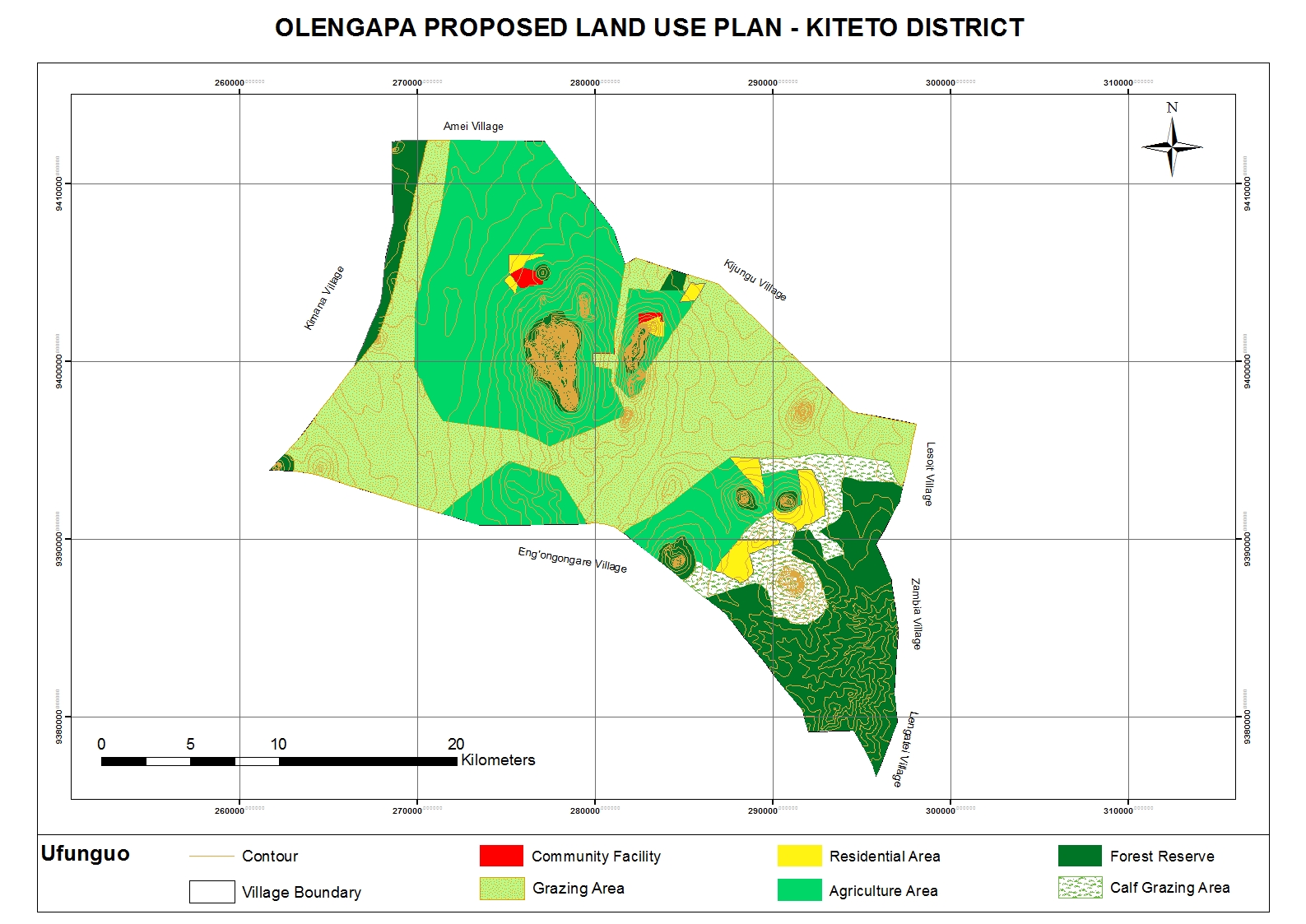
The Sustainable Rangeland Management Project (SRMP) is an initiative led by Tanzania’s Ministry of Livestock and Fisheries (MoLF), the International Livestock Research Institute (ILRI) and the National Land Use Planning Commission (NLUPC), with support from International Fund for Agricultural Development (IFAD), Irish Aid and the International Land Coalition (ILC). A key innovation of the project has been the development of joint village land use planning (JVLUP). The JVLUP process in Kiteto District, Manyara Region began in November 2013, and included the villages of Lerug, Ngapapa, and Orkitikiti. The three villages share boundaries and grazing resources, and in order to illustrate a single shared identity across the boundaries, the name OLENGAPA was chosen - incorporating part of each village’s name.
The total area of the three villages is (approx.) 59,000 hectares. The majority of inhabitants are Maasai pastoralists with some Ndorobo hunter-gatherers, and some farmers - most of whom are seasonal migrants. Mobility is central to the survival of the pastoralists and takes place across the three villages, as well as to locations in Kilindi, Gairo, and Bagamoyo Districts.
Average annual rainfall is between 800-1,000 mm per annum. There are no perennial rivers flowing through the OLENGAPA villages. The only permanent surface water source is Orkitikiti Dam, constructed in 1954.
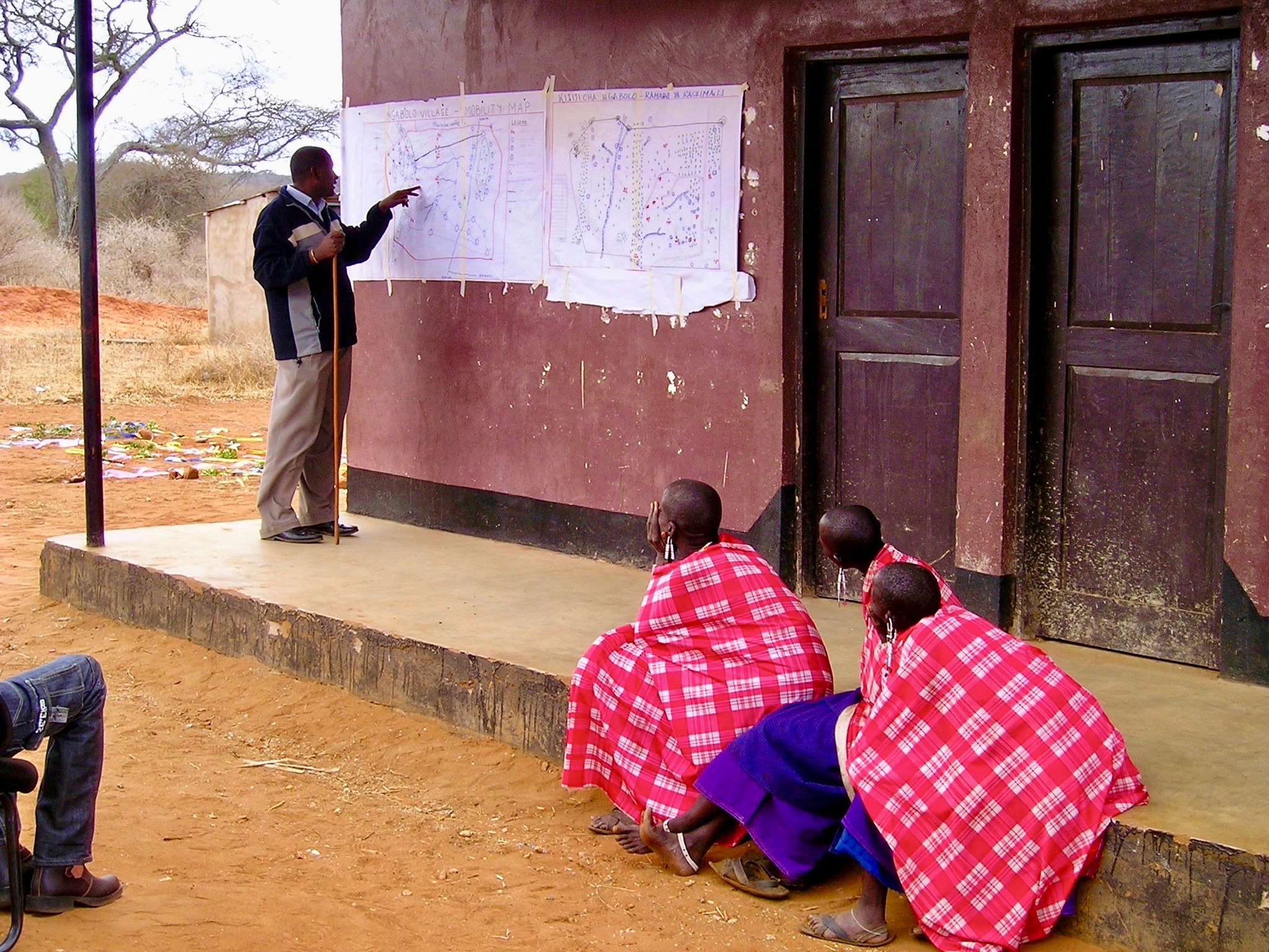
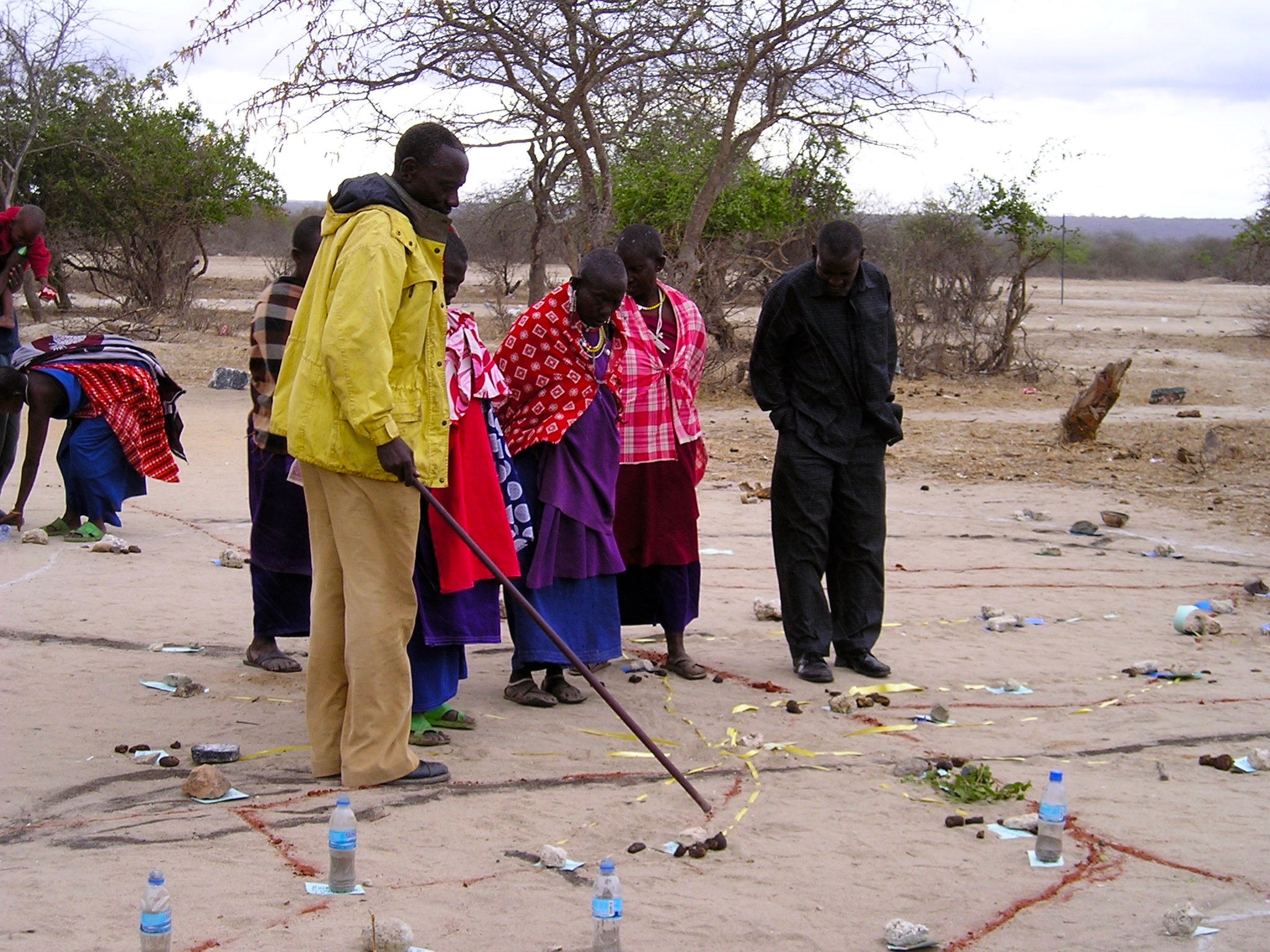
In order to understand the different resources such as grazing areas, water points, cropping areas, livestock routes, and cultural places, SRMP supported participatory mapping. This assisted in developing a base map for the village land use planning process: it showed which resources were shared by the villages and where they were situated.
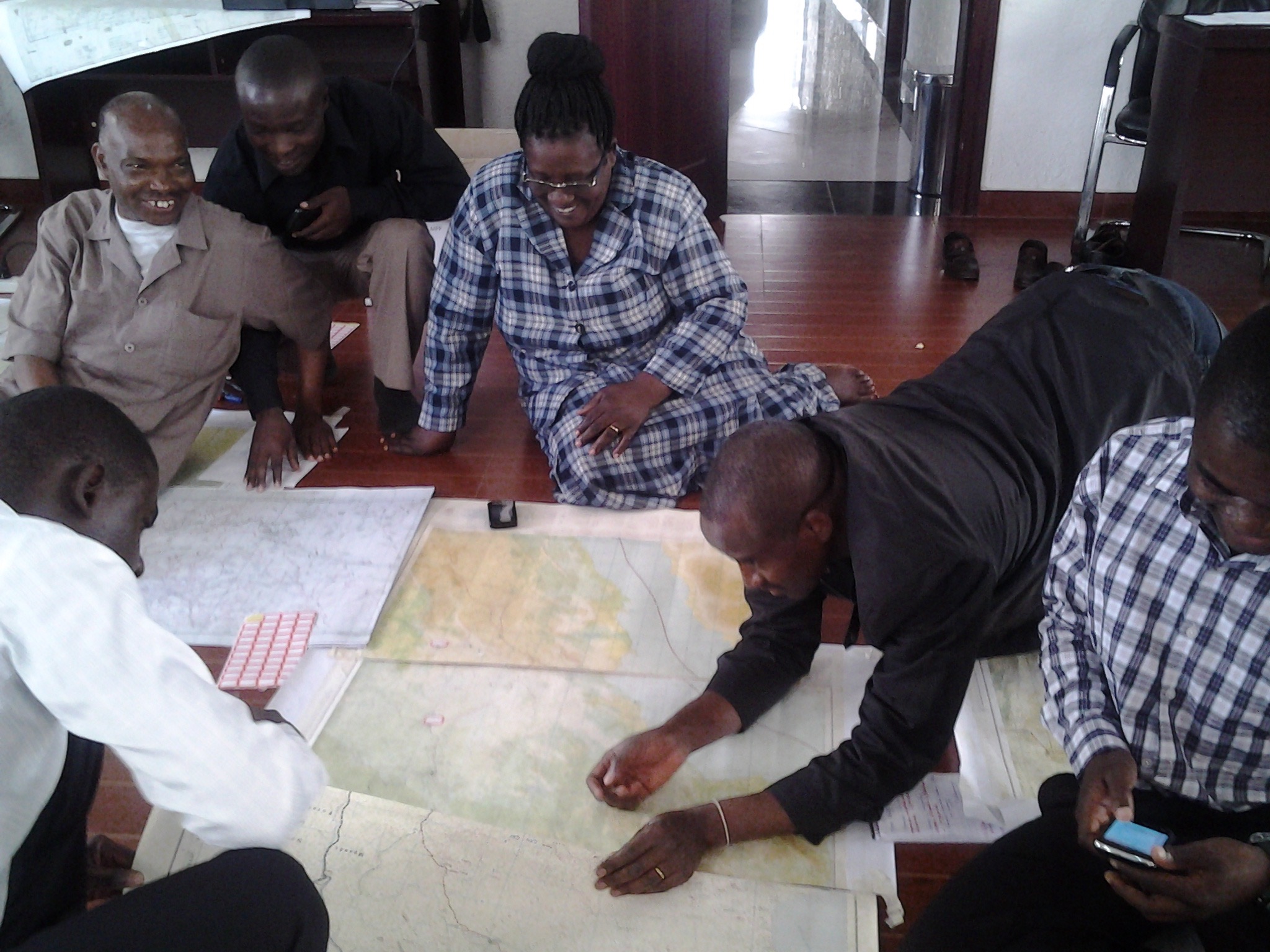
SRMP then helped village members to agree the individual village land use maps and plans - which zoned the village land into priority land uses - as well as the joint village land use map and plan, and the joint village land use agreement (JVLUA). These specified the grazing areas, water points, livestock routes and other shared resources. Reaching agreement was a protracted negotiation process between the villages, and within villages also - between different interest groups. It involved numerous community meetings and considerable investment of resources. Finally, each Village Assembly approved the JVLUA, which allocated approx. 20,700 ha of land for shared grazing –around 40% of the total village area. By-laws for management of the resources were developed and adopted.
Following approval of the JVLUA, the three OLENGAPA Village Councils established a Joint Grazing Land Committee made up of members from all three villages. This Committee is responsible for planning, management, enforcement of by-laws applicable to the OLENGAPA, and coordination of the implementation of both the OLENGAPA land use agreements and joint land use plan. In addition, a Livestock Keepers Association was established, including 53 founding members – but with most households from the three villages being associate members. A constitution was developed for the Association, which was officially registered on 11 September 2015.
In January 2016 the Ministry of Lands approved and registered the village land boundary maps and deed plans for the three villages. The District Council has issued the village land certificates, and the next step is for Village Councils to begin issuing Certificates of Customary Rights of Occupancy (CCROs). The shared grazing area will require three group CCROs to be issued to the Livestock Keepers Association – one from each village - for the part of the grazing area that falls under its jurisdiction. Signboards and beacons marking the shared grazing area are being put in place.
In November 2017 a fourth village joined OLENGAPA, expanding the shared grazing area to 30,000 ha. The villages are now working to develop a management plan to improve rangeland productivity.
2.3 รูปภาพของแนวทาง
อัลบั้มสื่อบันทึก
2.5 ประเทศ ภูมิภาค หรือสถานที่ตั้งที่ได้นำแนวทางไปใช้
ประเทศ:
แทนซาเนีย
ภูมิภาค/รัฐ/จังหวัด: :
Manyara Region
ข้อมูลเฉพาะเพิ่มเติมของสถานที่ตั้ง:
Kiteto District
ความคิดเห็น:
Kiteto District, Manyara Region, Tanzania
Map
×2.6 วันที่เริ่มต้นและสิ้นสุดของแนวทาง
ระบุปีที่เริ่ม:
2010
การสิ้นสุดลง (ถ้าแนวทางไม่ได้ใช้อีกต่อไป):
2017
2.7 ประเภทของแนวทาง
- ใช้โครงงานหรือแผนงานเป็นฐาน
2.8 เป้าหมายหรือวัตถุประสงค์หลักของแนวทาง
To secure shared grazing areas and other rangeland resources for livestock keepers, and to improve their management.
2.9 เงื่อนไขที่เอื้ออำนวยหรือเป็นอุปสรรคต่อการนำเทคโนโลยีภายใต้แนวทางนี้ไปปฏิบัติใช้
บรรทัดฐานและค่านิยมทางสังคม วัฒนธรรม ศาสนา
- เอื้ออำนวย
History of collective tenure, management and sharing of rangeland resources as part of sustainable rangeland management practices.
- เป็นอุปสรรค
Marginalisation of pastoralists from decision-making processes at local and higher levels.
การมีไว้ให้หรือการเข้าถึงแหล่งการเงินและบริการ
- เป็นอุปสรรค
Village land use planning process is costly due to the requirement to include government experts in the process in order to gather required data and to authorise plans. Lack of government priority to village land use planning, so poor allocation of government funds to the process.
การจัดตั้งระดับองค์กร
- เอื้ออำนวย
Strong local government/community institutions for leading process at local albeit their capacity may require building.
การร่วมมือหรือการทำงานประสานกันของผู้ลงมือปฏิบัติ
- เป็นอุปสรรค
Poor coordination of different actors supporting VLUP in the past due to previous weakness of National Land Use Planning Commission (NLUPC). However, this is now changing as NLUPC becomes stronger and takes up coordination role.
กรอบแนวทางในการดำเนินการด้านกฎหมาย (การถือครองที่ดิน สิทธิในการใช้ที่ดินและน้ำ)
- เอื้ออำนวย
Tanzania's legislation, if implemented well, provides an enabling environment for securing of community/village rights for both individuals and groups.
- เป็นอุปสรรค
Legislation allows village land to be transferred into public land if in the "public" or "national" interest - this facility confers insecurity on village land.
นโยบาย
- เอื้ออำนวย
Tanzania possesses facilitating national land use policy for the joint village land use planning approach, together with guidelines.
- เป็นอุปสรรค
There are conflicting policies over land coming from different sectors including land generally, together with forests, wildlife and livestock. These cause confusion at the local level. Depending on power of actors one set of policies may be stronger than another - wildlife-related policy for example can have a lot of power because there are many strong and influential tourism and conservation bodies lobbying for stronger protection of land, with potentially negative impacts for communities who want to use that land for other purposes.
การกำกับดูแลที่ดิน (การตัดสินใจ การนำเอาไปปฏิบัติใช้ และการบังคับใช้)
- เอื้ออำนวย
Decision-making has been decentralised to the lowest levels, giving local communities considerable power to decide on the uses of their village land.
- เป็นอุปสรรค
The process of village land use planning is costly due to the requirement for having local government experts involved, and the need to follow often complex procedures and steps. Many communities and even local government do not have adequate technical skills and knowledge to complete the long process, as well as not having adequate funds. This has held up the VLUP applications. Further few VLUPs move from their production stage to implementation stage including enforcement of bylaws and, for example, land management.
ความรู้เกี่ยวกับ SLM การเข้าถึงการสนับสนุนด้านเทคนิค
- เอื้ออำนวย
Good local knowledge of rangeland management based on historical practice. Communities understand need for better rangeland management.
- เป็นอุปสรรค
Lack of investment in rangeland management and the provision of technical support e.g. through government extension services. Lack of technical knowledge in rangeland rehabilitation and improving rangeland productivity at scale.
ตลาด (จัดซื้อปัจจัยนำเข้า ขายผลิตภัณฑ์) และราคา
- เป็นอุปสรรค
Lack of local markets and coordinated operations for livestock production.
ปริมาณงานที่ทำได้ กำลังคนที่มีให้
- เอื้ออำนวย
Well-structured local community bodies ready to provide manpower. Local government experts in place to support VLUP process.
- เป็นอุปสรรค
Lack of knowledge, skills and capacity amongst local communities and government experts to complete JVLUP adequately, including such as resolving conflicts between different land users.
3. การมีส่วนร่วมและบทบาทของผู้มีส่วนได้ส่วนเสียที่เกี่ยวข้อง
3.1 ผู้มีส่วนได้ส่วนเสียที่เกี่ยวข้องในแนวทางนี้และบทบาท
- ผู้ใช้ที่ดินระดับท้องถิ่นหรือชุมชนระดับท้องถิ่น
Village members (Assembly) of three villages - Orikitiki, Lerug and Ngapapa.
All village members as the Village Assembly have an opportunity to contribute to the land use planning process and to approve it.
- องค์กรที่ขึ้นอยู่กับชุมชน
Village Council, Village Land Use Management Committee (VLUMC), Rangeland Management Committee, Livestock Keepers Association.
Village government coordinated the planning process at local level. VLUMC develops plan. Village Council approves plans and issues CCROs. Rangeland Management Committee oversees development in rangelands. Livestock Keepers Association established made-up of all members of the villages that have livestock (nearly all village members) - they will be issued with CCROs as "owners" of the grazing land.
- ผู้เชี่ยวชาญ SLM หรือที่ปรึกษาการเกษตร
Land use planning consultants
Provision of advice to the project team, local government and villagers on the JVLUP approach.
- นักวิจัย
International Livestock Research Institute (ILRI)
Identification of good practice in village land use planning in Tanzania and ways to adapt and incorporate good practice into joint village land use planning to improve the approach. Research on role of and impact on pastoral women. Undertaking of baseline studies.
- องค์กรพัฒนาเอกชน
KINNAPA Development Association (supported originally by CARE and Tanzania Natural Resource Forum).
KINNAPA is the local CSO partner working as part of the project to implement the JVLUP with local communities
- รัฐบาลระดับท้องถิ่น
District Council including the PLUM (participatory land use management planning experts)
The District Council provides local government oversight of the planning process and approves the plan before submitting to national government body. The PLUM technically supports the development of the JVLUP working with the village government(s) and village committees.
- รัฐบาลแห่งชาติ (ผู้วางแผน ผู้ทำการตัดสินใจ)
Ministry of Livestock and Fisheries, National Land Use Planning Commission (NLUPC), Ministry of Lands, Housing and Human Settlements Development,
Ministry of Livestock and Fisheries leading the planning process with a sectoral interest in protecting rangelands. NLUPC provides technical oversight and guidance. Ministry of Lands is the national body that approves the final plan.
- องค์การระหว่างประเทศ
International Land Coalition (ILC)
ILC is the grant recipient for the funds from the donors. The project is implemented through ILC members such as ILRI. ILC coordinates its members work in Tanzania on land issues including the JVLUP through a national engagement strategy (NES). ILC also provides technical support to the process through its global/Africa programme - the ILC Rangelands Initiative. The ILC Rangelands Initiative is a platform for learning, sharing, influencing, and connecting on rangeland issues with the objective of making rangelands more secure.
- Donors
IFAD and Irish Aid
Provide funds for the project. IFAD also provides technical support on land tenure issues.
ถ้ามีผู้มีส่วนได้ส่วนเสียหลายคนที่เกี่ยวข้องให้ระบุหน่วยงานตัวแทน:
The lead agency is the International Land Coalition (ILC) working through its members including ILRI. In country, the main implementer is the Ministry of Livestock and Fisheries
3.2 การเกี่ยวข้องของผู้ใช้ที่ดินระดับท้องถิ่นหรือชุมชนระดับท้องถิ่นในช่วงต่างๆของแนวทาง
| ความเกี่ยวข้องของผู้ใช้ที่ดินระดับท้องถิ่นหรือชุมชนระดับท้องถิ่น | ระบุผู้ที่มีส่วนเกี่ยวข้องและอธิบายกิจกรรม | |
|---|---|---|
| การริเริ่มหรือการจูงใจ | จ่ายเงินหรือสนับสนุนจากภายนอก | The project supported communities to initiate the first steps taken to reach agreement on the need for planning and how this would be done. |
| การวางแผน | ปฏิสัมพันธ์ | Communities were centrally involved in the planning of the VLUP process, with support from local NGO and government. |
| การดำเนินการ | ปฏิสัมพันธ์ | Village government and community in general is responsible for the implementation of the planning process, with the support of local government. |
| การติดตามตรวจสอบหรือการประเมินผล | จ่ายเงินหรือสนับสนุนจากภายนอก | The community is responsible for monitoring and evaluation, but lack skills and capacity in this regard requiring external support. |
| Research | จ่ายเงินหรือสนับสนุนจากภายนอก | Research on information required for planning processes collected and generated by communities with the assistance of technical support from local NGO, local government and researchers. |
3.3 แผนผังแสดงขั้นตอนการทำงาน (ถ้ามี)
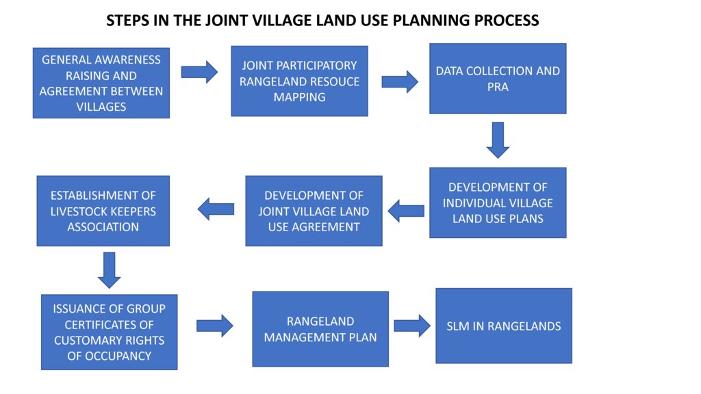
คำอธิบาย:
Steps in the Joint Village Land Use Planning Process
ผู้เขียน:
Fiona Flintan
3.4 การตัดสินใจเลือกใช้เทคโนโลยี SLM
ระบุผู้ที่ทำการตัดสินใจเลือกเทคโนโลยีมากกว่าหนึ่งวิธีไปปฏิบัติใช้:
- ผู้ลงมือปฏิบัติที่เกี่ยวข้องทั้งหมดในฐานะที่เป็นส่วนรวมของแนวทาง
การอธิบาย:
The policy and legislation lays down the steps to be followed for the VLUP/JVLUP process. However there is room to adapt these processes to local context - and here all stakeholders were involved to develop the process of JVLUP through its first piloting. This included communities, local and national government, local NGOs, researchers and development organisations.
ระบุว่าการตัดสินใจตั้งอยู่บนพื้นฐานของ:
- การประเมินความรู้ SLM ที่ได้ทำการบันทึกไว้เป็นอย่างดี (การใช้ข้อมูลในการตัดสินใจ)
4. การสนับสนุนด้านเทคนิค การสร้างขีดความสามารถ และการจัดการด้านความรู้
4.1 การสร้างขีดความสามารถ / การอบรม
ได้มีการจัดอบรมให้แก่ผู้ใช้ที่ดินหรือผู้มีส่วนได้ส่วนเสียคนอื่น ๆ หรือไม่:
ใช่
ให้ระบุว่าใครเป็นผู้ได้รับการอบรม:
- ผู้ใช้ที่ดิน
- เจ้าหน้าที่ภาคสนาม / ที่ปรึกษา
- government staff
รูปแบบการอบรม:
- กำลังดำเนินการ
- จัดการประชุมสู่สาธารณชน
- จัดคอร์ส
หัวข้อที่พูด:
Land users were trained in land related and other relevant laws and the JVLUP process. Field staff/advisers were trained in land laws, the JVLUP process, gender, and conflict resolution. Local government were trained in the JVLUP process, gender and conflict resolution.
4.2 การบริการให้คำแนะนำ
ผู้ใช้ที่ดินมีการเข้าถึงการรับบริการให้คำปรึกษาหรือไม่:
ไม่ใช่
4.3 การเสริมความแข็งแกร่งให้กับสถาบัน (การพัฒนาองค์กร)
สถาบันได้รับการจัดตั้งขึ้นมาหรือเสริมความแข็งแกร่งโดยแนวทางนี้หรือไม่:
- ใช่ อย่างมาก
ระบุระดับของสถาบันที่ได้รับการเสริมความแข็งแกร่งหรือจัดตั้งขึ้นมา:
- ท้องถิ่น
- ประเทศ
อธิบายถึงสถาบัน บทบาทและความรับผิดชอบ สมาชิก เป็นต้น:
Local government bodies including Village Council, VLUMC (village land use management committee) and Livestock Keepers Association have all had capacity strengthened, but more is required (particularly for the latter). Capacity of the Ministry of Livestock and Fisheries and the National Land Use Planning Commission to implement JVLUP has been built.
ระบุประเภทของการให้ความช่วยเหลือสนับสนุน:
- ด้านการเงิน
- การสร้างขีดความสามารถ / การอบรม
- อุปกรณ์
- data collected and database set up
4.4 การติดตามตรวจสอบและประเมินผล
การติดตามตรวจสอบและประเมินผลเป็นส่วนหนึ่งของแนวทางหรือไม่:
ใช่
ความคิดเห็น:
M&E has not been strong in previous phases, but now is central with baselines being carried out in all new clusters of villages where the project will work so that impact can be fully assessed.
ถ้าตอบว่าใช่ แสดงว่าการจัดเตรียมเอกสารนี้มุ่งหวังที่จะเอาไปใช้สำหรับการติดตามตรวจสอบและประเมินผลใช่หรือไม่:
ไม่ใช่
4.5 การวิจัย
การวิจัยเป็นส่วนหนึ่งของแนวทางหรือไม่:
ใช่
ระบุหัวข้อเรื่อง:
- สังคมวิทยา
- เศรษฐศาสตร์หรือการตลาด
- นิเวศวิทยา
ให้ข้อมูลเพิ่มเติมและให้ระบุผู้ทำการวิจัย:
Research was carried out to identify good practice (in terms of social, economic and environmental impacts) from which the JVLUP process was developed. In future phases the full impacts of this JVLUP in terms of social, economic and ecological impact are being researched.
5. การสนับสนุนด้านการเงินและวัสดุอุปกรณ์
5.1 ระบุงบประมาณประจำปีสำหรับแนวทาง SLM นี้
ถ้าหากว่างบประมาณประจำปีไม่เป็นที่ทราบแน่นอน ให้ระบุช่วงลงไป:
- 10,000-100,000
แสดงความคิดเห็น (แหล่งของการระดมทุน ผู้บริจาคคนสำคัญ):
IFAD, Irish Aid,
5.2 การสนับสนุนด้านการเงิน / วัสดุอุปกรณ์ให้แก่ผู้ใช้ที่ดิน
ผู้ใช้ที่ดินได้รับการสนับสนุนด้านการเงิน / วัสดุอุปกรณ์ไปปฏิบัติใช้เทคโนโลยีหรือไม่:
ไม่ใช่
5.3 เงินสนับสนุนสำหรับปัจจัยนำเข้า (รวมถึงแรงงาน)
- ไม่มี
ถ้าแรงงานโดยผู้ใช้ที่ดินเป็นปัจจัยนำเข้าที่มีอยู่มากมาย ระบุด้วยว่าเนื่องจาก:
- สมัครใจ
ความคิดเห็น:
Labour was voluntary with meal provided and/or travel costs covered.
5.4 เครดิต
มีการจัดหาเครดิตมาให้ภายใต้แนวทาง SLM หรือไม่:
ไม่ใช่
5.5 แรงจูงใจหรือเครื่องมืออื่น ๆ
แรงจูงใจหรือเครื่องมืออื่น ๆ ได้ถูกนำไปใช้ส่งเสริมการใช้เทคโนโลยี SLM หรือไม่:
ใช่
ถ้าใช่ ระบุ:
Tanzanian policy and legislation states that all village should have a VLUP, therefore this was an incentive for stakeholders to invest in the process. In addition conflicts over land use are increasingly a problem in Tanzania - so the resolution of these was also an important incentive.
6. การวิเคราะห์ผลกระทบและการสรุป
6.1 ผลกระทบของแนวทาง
ทำให้ผู้ใช้ที่ดินระดับท้องถิ่นมีอำนาจขึ้น ปรับปรุงการเข้าร่วมของผู้มีส่วนได้ส่วนเสียให้ดีขึ้นหรือไม่:
- ไม่ใช่
- ใช่ เล็กน้อย
- ใช่ ปานกลาง
- ใช่ อย่างมาก
Local village communities now feel strongly empowered in protecting and managing their land. The process has brought different stakeholders together and strengthened commitment to make the process work.
ช่วยในการตัดสินใจโดยดูจากหลักฐาน ได้หรือไม่:
- ไม่ใช่
- ใช่ เล็กน้อย
- ใช่ ปานกลาง
- ใช่ อย่างมาก
The piloting of the JVLUP showed what is possible and the positive impacts realised (albeit they could have been better documented). On these results the process is being scaled-up.
ช่วยให้ผู้ใช้ที่ดินนำเอาเทคโนโลยี SLMไปใช้และบำรุงรักษาสภาพไว้ได้หรือไม่:
- ไม่ใช่
- ใช่ เล็กน้อย
- ใช่ ปานกลาง
- ใช่ อย่างมาก
The planning process has laid the foundations for improved rangeland management - what is now required is investment in that management.
ปรับปรุงความร่วมมือกันและการดำเนิน งานของ SLM ได้อย่างมีประสิทธิผลหรือไม่:
- ไม่ใช่
- ใช่ เล็กน้อย
- ใช่ ปานกลาง
- ใช่ อย่างมาก
ระดมกำลังหรือปรับปรุงการเข้าถึงแหล่ง เงินทุนสำหรับการดำเนินการ SLM หรือไม่:
- ไม่ใช่
- ใช่ เล็กน้อย
- ใช่ ปานกลาง
- ใช่ อย่างมาก
ปรับปรุงความรู้และความสามารถของผู้ใช้ที่ดินในการดำเนินการ SLM หรือไม่:
- ไม่ใช่
- ใช่ เล็กน้อย
- ใช่ ปานกลาง
- ใช่ อย่างมาก
Land users have greater knowledge of the potential and need for rangeland management based on a better understanding of their land and resources gained through the JVLUP process, but they still need skills and resources to put this knowledge into action.
ปรับปรุงความรู้และความสามารถของผู้มีส่วนได้ส่วนเสียคนอื่น ๆ ให้ดีขึ้นหรือไม่:
- ไม่ใช่
- ใช่ เล็กน้อย
- ใช่ ปานกลาง
- ใช่ อย่างมาก
National and local government have seen the potential of the JVLUP to resolve conflicts over land use, and their capacities to implement the JVLUP in this regard has been improved.
ทำให้ผู้ใช้ที่ดินระดับท้องถิ่นมีอำนาจขึ้น ปรับปรุงการเข้าร่วมของผู้มีส่วนได้ส่วนเสียให้ดีขึ้นหรือไม่:
- ไม่ใช่
- ใช่ เล็กน้อย
- ใช่ ปานกลาง
- ใช่ อย่างมาก
The approach is helping build relations between the Ministry Livestock and Fisheries and the NLUPC together with NGO(s) at national level, as well as between different stakeholders involved in JVLUP at local levels.
ช่วยบรรเทาความขัดแย้งหรือไม่:
- ไม่ใช่
- ใช่ เล็กน้อย
- ใช่ ปานกลาง
- ใช่ อย่างมาก
Through the process of JVLUP the roots of land use conflicts come to the surface and must be resolved before agreement is reached. This may cause tensions and even conflict along the way - but the outcome should be positive.
ทำให้กลุ่มด้อยโอกาสมีอำนาจทางสังคมและเศรษฐกิจหรือไม่:
- ไม่ใช่
- ใช่ เล็กน้อย
- ใช่ ปานกลาง
- ใช่ อย่างมาก
Pastoralists are often left out of village land use planning processes. This approach when implemented well gives greater opportunity for them to be involved. However this is still a challenge.
ปรับปรุงความทัดเทียมกันด้านเพศและให้อำนาจแก่ผู้หญิงและเด็กผู้หญิงหรือไม่:
- ไม่ใช่
- ใช่ เล็กน้อย
- ใช่ ปานกลาง
- ใช่ อย่างมาก
Women can be left out of village land use planning processes. This approach when implemented well gives greater opportunity for them to be involved. However this is still a challenge.
ส่งเสริมให้เยาวชนหรือบุตรหลานของผู้ใช้ที่ดินให้เข้าร่วมใน SLM:
- ไม่ใช่
- ใช่ เล็กน้อย
- ใช่ ปานกลาง
- ใช่ อย่างมาก
Youth can be left out of village land use planning processes. This approach when implemented well gives greater opportunity for them to be involved. However this is still a challenge.
ปรับปรุงประเด็นของการถือครองที่ดินหรือสิทธิในการใช้ ซึ่งขัดขวางการนำเทคโนโลยีไปใช้ให้ดีขึ้น:
- ไม่ใช่
- ใช่ เล็กน้อย
- ใช่ ปานกลาง
- ใช่ อย่างมาก
By following the JVLUP process village land has been certified and secured, as well as the rights of access and use of livestock keepers to the grazing land.
นำไปสู่ความมั่นคงด้านอาหารหรือปรับปรุงโภชนาการให้ดีขึ้น:
- ไม่ใช่
- ใช่ เล็กน้อย
- ใช่ ปานกลาง
- ใช่ อย่างมาก
This has not been specifically monitored but it assumed by having stronger security to land and resources, food security and nutrition will be improved.
ปรับปรุงการเข้าถึงตลาดหรือไม่:
- ไม่ใช่
- ใช่ เล็กน้อย
- ใช่ ปานกลาง
- ใช่ อย่างมาก
This has not been specifically monitored but it assumed by having stronger security to land and resources, access to markets will be improved.
นำไปสู่การเข้าถึงเรื่องน้ำและสุขาภิบาลได้ดีขึ้นหรือไม่:
- ไม่ใช่
- ใช่ เล็กน้อย
- ใช่ ปานกลาง
- ใช่ อย่างมาก
In terms of water for livestock the JVLUP process has secured rights for the three villages to shared water resources.
นำไปสู่การใช้ที่ดินอย่างยั่งยืนหรือแหล่งพลังงานหรือไม่:
- ไม่ใช่
- ใช่ เล็กน้อย
- ใช่ ปานกลาง
- ใช่ อย่างมาก
ปรับปรุงความสามารถของผู้ใช้ที่ดินในการปรับตัวให้เข้ากับการเปลี่ยนแปลงของสภาพภูมิอากาศหรือสภาพที่รุนแรงและภัยพิบัติหรือไม่:
- ไม่ใช่
- ใช่ เล็กน้อย
- ใช่ ปานกลาง
- ใช่ อย่างมาก
By having stronger security to land and resources local land users are better placed to adapt to climate change etc.
นำไปสู่โอกาสในการจ้างงาน รายได้หรือไม่:
- ไม่ใช่
- ใช่ เล็กน้อย
- ใช่ ปานกลาง
- ใช่ อย่างมาก
This has not been specifically monitored but it assumed by having stronger security to land and resources, income opportunities will be improved.
6.2 แรงจูงใจหลักของผู้ใช้ที่ดินเพื่อที่จะนำ SLM ไปปฏิบัติใช้
- การผลิตที่เพิ่มขึ้น
By protecting grazing areas, there will be more secure access to resources required for livestock production.
- การเสื่อมของที่ดินลดลง
By protecting grazing areas and improvement of rangeland management practices land degradation will be reduced.
- ความเสี่ยงของภัยพิบัติลดลง
With more secure access to land and resources, local land users are better placed to manage their resources in order to reduce risks to disasters.
- กฎและระเบียบ (ค่าปรับ) หรือการบังคับใช้
By gaining protection from village certification, village land use planning and local bylaws developed as part of this, local land users are better placed to enforce rules and regulations relating to land use and to prevent encroachment/trespassing by outsiders.
- เกียรติภูมิ แรงกดดันทางสังคม ความเชื่อมแน่นทางสังคม
The JVLUP process improved the social cohesion and group identify of the three villages - expressed in the name OLENGAPA (made up of the three village names). There is a strong livestock keepers association now made up of livestock keepers from all three villages who are working more closely together.
- การบรรเทาด้านความขัดแย้ง
The JVLUP helped to resolve land use conflicts by opening up space to discuss root causes, find solutions and come to agreement between land users.
6.3 ความยั่งยืนของกิจกรรมของแนวทาง
ผู้ใช้ที่ดินสามารถทำให้สิ่งต่างๆ ที่ได้ปฏิบัติใช้โดยแนวทางนี้ยั่งยืนได้หรือไม่ (โดยไม่มีการสนับสนุนจากภายนอก):
- ไม่แน่ใจ
ถ้าตอบว่าไม่หรือไม่แน่ใจ ให้ระบุและแสดงความคิดเห็น :
The community requires support from local government to protect their village lands including grazing lands from outsiders wanting to settle on the land - this is a constant problem to be addressed (despite the securing of village boundaries etc.). The community also needs capacity building and resources to improve the productivity of the land including the grazing areas. If they get these supports then they can sustain what has been implemented.
6.4 จุดแข็งและข้อได้เปรียบของแนวทาง
| จุดแข็ง / ข้อได้เปรียบของแนวทางในทัศนคติของผู้ใช้ที่ดิน |
|---|
| Improved the security of access and use to village land including grazing. |
| Brought attention to the challenges faced by land users in the area in protecting and using their village land, and the need for more investment and support for this. |
| Pastoralists are now more central to decision-making processes than they were before. |
| จุดแข็ง / ข้อได้เปรียบของแนวทางในทัศนคติของผู้รวบรวมหรือวิทยากรหลัก |
|---|
| Collaboration of different stakeholders in implementing the approach has supported a new way of working. |
| Capacity of different stakeholders has been built along the way through joint problem-solving and learning-by-doing. |
| The approach - with adaptation - has application in other contexts/countries and shows that even if a rangeland is split by administrative boundaries there is opportunity to work across those village boundaries in order to maintain the functionality of the rangeland and land use systems such as pastoralism that depend upon this. |
6.5 จุดอ่อน / ข้อเสียเปรียบของแนวทางและวิธีในการแก้ไข
| จุดอ่อน / ข้อเสียเปรียบในทัศนคติของผู้ใช้ที่ดิน | สามารถแก้ไขปัญหาได้อย่างไร |
|---|---|
| Despite village land being theoretically protected, in practice it can still be encroached upon. | Greater support provided from government to enforce protection of land. |
| Time-consuming process which became more expensive than anticipated resulting in some gaps in funding. | Process needs to be refined through practice, and adequate funds allocated from beginning. |
| จุดอ่อน / ข้อเสียเปรียบในทัศนคติของผู้รวบรวมหรือวิทยากรหลัก | สามารถแก้ไขปัญหาได้อย่างไร |
|---|---|
| The selection of villages for JVLUP needs more care to ensure that enabling conditions for JVLUP exist. | In future selection of villages for JVLUP a set of criteria should be used that enable more enabling conditions to exist. |
| Information has not been methodologically collected on social, environmental and economic impacts of the approach. | In future the impacts of the approach need to be fully monitored and evaluated. |
| The VLUP is an expensive process to follow. | National government needs to identify ways to reduce the cost of the VLUP so that more villages can undertake it. Government needs to allocate more funds to VLUP. The VLUP is an expensive process to follow. |
| Need for an enabling environment. | The policy and legislation in Tanzania enables this process - it is not the case in the majority of other African countries. |
7. การอ้างอิงและการเชื่อมต่อ
7.1 วิธีการหรือแหล่งข้อมูล
- การเก็บรวบรวมมาจากรายงานและเอกสารที่มีอยู่
The compiler has been involved in the project/process since its inception and had access to all reports and existing documentation.
7.3 เชื่อมโยงกับข้อมูลที่มีอยู่บนออนไลน์
ชื่อเรื่องหรือคำอธิบาย:
Kalenzi, D. 2016. Improving the implementation of land policy and legislation in pastoral areas of Tanzania: Experiences of joint village land use agreements and planning. Rangelands 7. Rome, Italy: International Land Coalition.
URL:
https://cgspace.cgiar.org/handle/10568/79796
ชื่อเรื่องหรือคำอธิบาย:
Daley, E., Kisambu, N. and Flintan, F. 2017. Rangelands: Securing pastoral women’s land rights in Tanzania. Rangelands Research Report 1. Nairobi, Kenya: ILRI.
URL:
https://cgspace.cgiar.org/handle/10568/89483
ชื่อเรื่องหรือคำอธิบาย:
International Livestock Research Institute. 2017. Sustainable Rangeland Management Project, Tanzania. ILRI Project Brochure. Nairobi, Kenya: ILRI.
URL:
https://cgspace.cgiar.org/handle/10568/80673
ชื่อเรื่องหรือคำอธิบาย:
International Land Coalition. 2014. Participatory rangeland resource mapping in Tanzania: A field manual to support planning and management in rangelands including in village land use planning. Rome: International Land Coalition
URL:
https://cgspace.cgiar.org/handle/10568/51348
ชื่อเรื่องหรือคำอธิบาย:
Flintan, F., Mashingo, M., Said, M. and Kifugo, S.C. 2014. Developing a national map of livestock routes in Tanzania in order to value service and protect them. Poster prepared for the ILRI@40 Workshop, Addis Ababa, 7 November 2014. Nairobi, Kenya: ILRI.
URL:
https://cgspace.cgiar.org/handle/10568/64964
ชื่อเรื่องหรือคำอธิบาย:
Village land use planning in rangelands in Tanzania, F. Flintan 2012
URL:
http://www.landcoalition.org/en/regions/africa/resources/no-3-village-land-use-planning-rangelands-tanzania
ชื่อเรื่องหรือคำอธิบาย:
Protecting shared grazing through joint village land use planning
URL:
http://www.landcoalition.org/en/regions/africa/resources/protecting-shared-grazing-through-joint-village-land-use-planning
ลิงก์และโมดูล
ขยายทั้งหมด ย่อทั้งหมดลิงก์
ไม่มีลิงก์
โมดูล
ไม่มีโมดูล