
Project of check-dam for land [จีน]
- ผู้สร้างสรรค์:
- การอัพเดท:
- ผู้รวบรวม: Fei WANG
- ผู้เรียบเรียง: –
- ผู้ตรวจสอบ: David Streiff
淤地坝工程
approaches_2450 - จีน
ดูส่วนย่อย
ขยายทั้งหมด ย่อทั้งหมด1. ข้อมูลทั่วไป
1.2 รายละเอียดที่ติดต่อได้ของผู้รวบรวมและองค์กรที่เกี่ยวข้องในการประเมินและการจัดเตรียมทำเอกสารของแนวทาง
ชื่อของโครงการซึ่งอำนวยความสะดวกในการทำเอกสารหรือการประเมินแนวทาง (ถ้าเกี่ยวข้อง)
Northwest A&F University (NWAFU) - จีน1.3 เงื่อนไขที่เกี่ยวข้องกับการใช้ข้อมูลที่ได้บันทึกไว้ผ่านทาง WOCAT
ผู้รวบรวมและวิทยากรหลักยอมรับเงื่อนไขเกี่ยวกับการใช้ข้อมูลที่ถูกบันทึกผ่านทาง WOCAT:
ใช่
1.4 การอ้างอิงถึงแบบสอบถามเรื่องเทคโนโลยี SLM

Check dam for land [จีน]
Check dam for land is a structural SLM practice that is constructed in the valley of a watershed in order to slow down the runoff and increase sedimentation. After this, the land quality of the controlling area will increase because soil and water conditions in this place are improved.
- ผู้รวบรวม: Fei WANG
2. คำอธิบายของแนวทาง SLM
2.1 การอธิบายแบบสั้น ๆ ของแนวทาง
Approach of check dam for land is a kind of soil and water conservation activity to reduce the sediment discharge and improve the agricultural condition through building a dam across the valley in order to silt the sediment from upstream untill it convert to land with few soil erosion and flash floods.
2.2 การอธิบายอย่างละเอียดของแนวทาง
การอธิบายอย่างละเอียดของแนวทาง:
Aims / objectives: The aims of this approach are to reduce sediment discharge of the rivers and to create cropland in the valley. A wall across the valley is built to hold up the muddy flash flood and to slow down the runoff and to silt the sediment. The water in the check dam could be used as waterbody or discharge as clear water. The local farmers and governments want to improve the agricultural condition in the valley near to village and select the check dam for land.
Methods: Normally the farmers and the local experts judge the feasibility of the technology firstly and then apply the support of local government. The construction should be finished by group (village) with labour input combining with finicial support outside.
Stages of implementation: The first stage to implenment this technology is to call on the local farmers with benefits show of such technologies. Then, an application should be submitted to local gevernment. After getting the support, the construction begin.
Role of stakeholders: The local farmers, experts and local government are main participants in this approach.
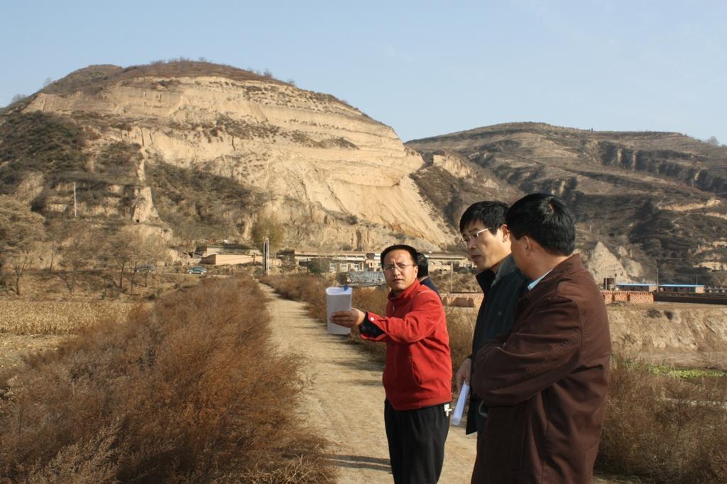
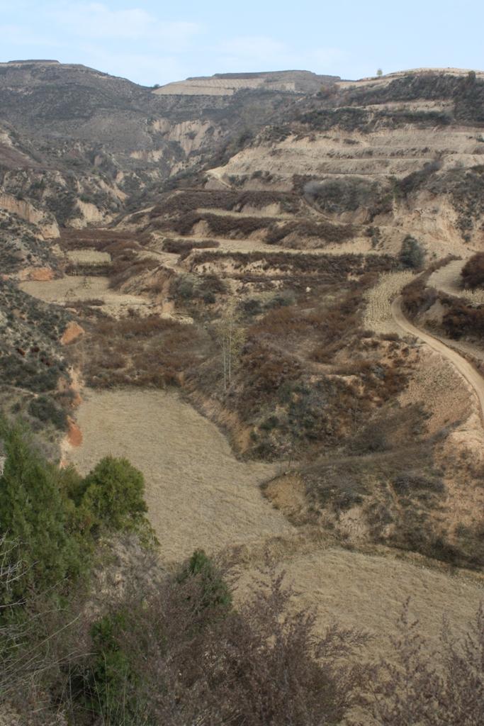
2.3 รูปภาพของแนวทาง
อัลบั้มสื่อบันทึก
2.5 ประเทศ ภูมิภาค หรือสถานที่ตั้งที่ได้นำแนวทางไปใช้
ประเทศ:
จีน
ภูมิภาค/รัฐ/จังหวัด: :
Shaanxi Province
ข้อมูลเฉพาะเพิ่มเติมของสถานที่ตั้ง:
Baota County, Yan'an City
ความคิดเห็น:
The total area with different measures is almost 2000 km2 . Yanhe River is a first class branch of Yellow River, China. The average channel slope is 3.26‰, and the area of whole basin is 7,687 km2. It is situated in the semi-arid North Temperate Zone with an average annual precipitation varying from 500 to 550 mm, and an average annual air temperature ranging from 8.5 to 11.4℃. It is in hilly gull
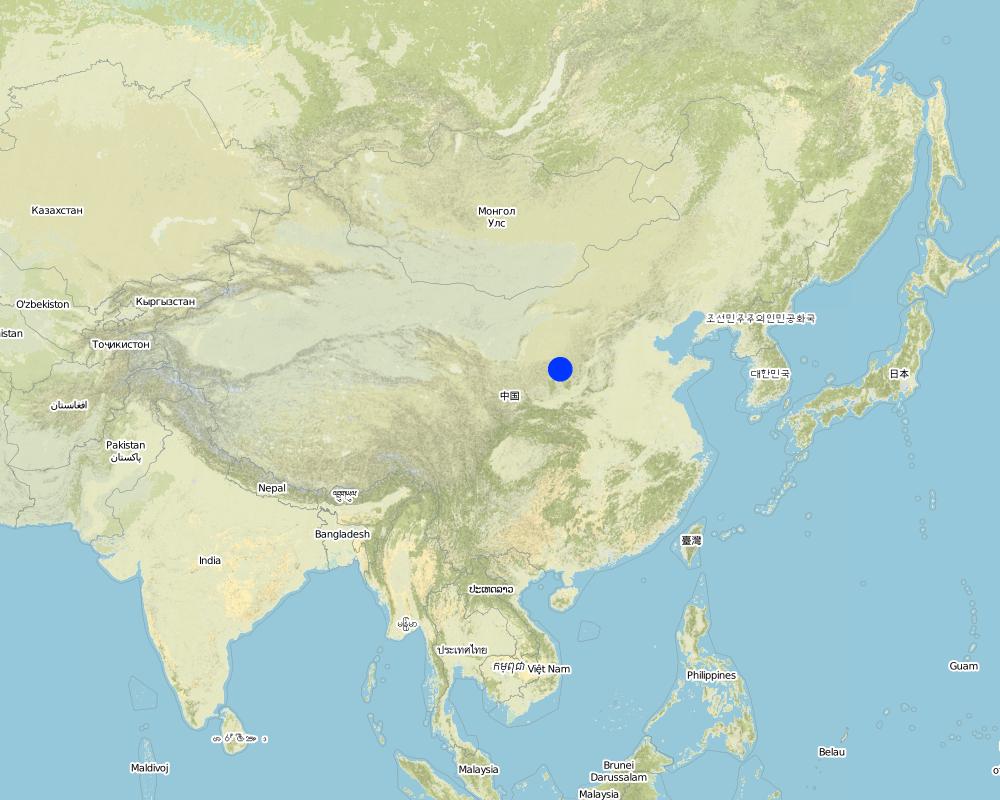
Map
×2.6 วันที่เริ่มต้นและสิ้นสุดของแนวทาง
ระบุปีที่เริ่ม:
18
การสิ้นสุดลง (ถ้าแนวทางไม่ได้ใช้อีกต่อไป):
16
2.7 ประเภทของแนวทาง
- ใช้โครงงานหรือแผนงานเป็นฐาน
2.8 เป้าหมายหรือวัตถุประสงค์หลักของแนวทาง
The Approach focused mainly on SLM with other activities (Structural practices; crop land; reduction of sediment load downstream)
1. it reduces the sediment load of the downstream or main river. 2. it improves the agricultural condition through the gain of new cropland in the valleys; 3. it reduces the soil erosion of gullies by down-cutting erosion; 4. it to reduces the gravity erosion or collapse of slopes because the land would increase the stability of slopes. 5. it designs the check dam well and search funds in order to construct the check dam.
The SLM Approach addressed the following problems: The problems include: lack of flat areas for crop production, high soil erosion on the slopes, poverty induced by low production, requirement of sediment control , lack of cash, and so on.
2.9 เงื่อนไขที่เอื้ออำนวยหรือเป็นอุปสรรคต่อการนำเทคโนโลยีภายใต้แนวทางนี้ไปปฏิบัติใช้
การมีไว้ให้หรือการเข้าถึงแหล่งการเงินและบริการ
- เป็นอุปสรรค
the input for a check dam is high for small households and villages
Treatment through the SLM Approach: financial support from outside such as local or central governemnt, or the management organization of water basin.
กรอบแนวทางในการดำเนินการด้านกฎหมาย (การถือครองที่ดิน สิทธิในการใช้ที่ดินและน้ำ)
- เอื้ออำนวย
The existing land ownership, land use rights / water rights greatly helped the approach implementation: The approach has many advantages for the different stakeholders. The existing land ownship, land user rights and water rights could help the approach implementation.
ความรู้เกี่ยวกับ SLM การเข้าถึงการสนับสนุนด้านเทคนิค
- เป็นอุปสรรค
A huge flood would destroy the dam
Treatment through the SLM Approach: To improve the quality which is depending on calculation of the possibility of flood and during extrem storms the control area of the dam.
3. การมีส่วนร่วมและบทบาทของผู้มีส่วนได้ส่วนเสียที่เกี่ยวข้อง
3.1 ผู้มีส่วนได้ส่วนเสียที่เกี่ยวข้องในแนวทางนี้และบทบาท
- ผู้ใช้ที่ดินระดับท้องถิ่นหรือชุมชนระดับท้องถิ่น
Some check dams were implemented by villagers, before
The land area of local farmers is very small, and the decision at the village level should be decided by the group.
- ผู้เชี่ยวชาญ SLM หรือที่ปรึกษาการเกษตร
The geologist designs the site of engineering, the hydyologist designs the ability of dam according the strom records and landform of the basin; the civil engineers design the number of engineers.
They can evaluate the properity of check dam for land and design it
- รัฐบาลระดับท้องถิ่น
The departments with certification to implement
They decide the planning of soil and water conservation.
- รัฐบาลแห่งชาติ (ผู้วางแผน ผู้ทำการตัดสินใจ)
By politicians / leaders
3.2 การเกี่ยวข้องของผู้ใช้ที่ดินระดับท้องถิ่นหรือชุมชนระดับท้องถิ่นในช่วงต่างๆของแนวทาง
| ความเกี่ยวข้องของผู้ใช้ที่ดินระดับท้องถิ่นหรือชุมชนระดับท้องถิ่น | ระบุผู้ที่มีส่วนเกี่ยวข้องและอธิบายกิจกรรม | |
|---|---|---|
| การริเริ่มหรือการจูงใจ | ระดมกำลังด้วยตนเอง | the local farmers and village head involved normally. They could build the check dam before but they submit the proposal for the building now. |
| การวางแผน | จ่ายเงินหรือสนับสนุนจากภายนอก | the experts in hydrology, soil erosion, landform involved. They survey, calculate and design the check dam. |
| การดำเนินการ | ปฏิสัมพันธ์ | |
| การติดตามตรวจสอบหรือการประเมินผล | ไม่มี | |
| Research | ไม่มี |
3.3 แผนผังแสดงขั้นตอนการทำงาน (ถ้ามี)
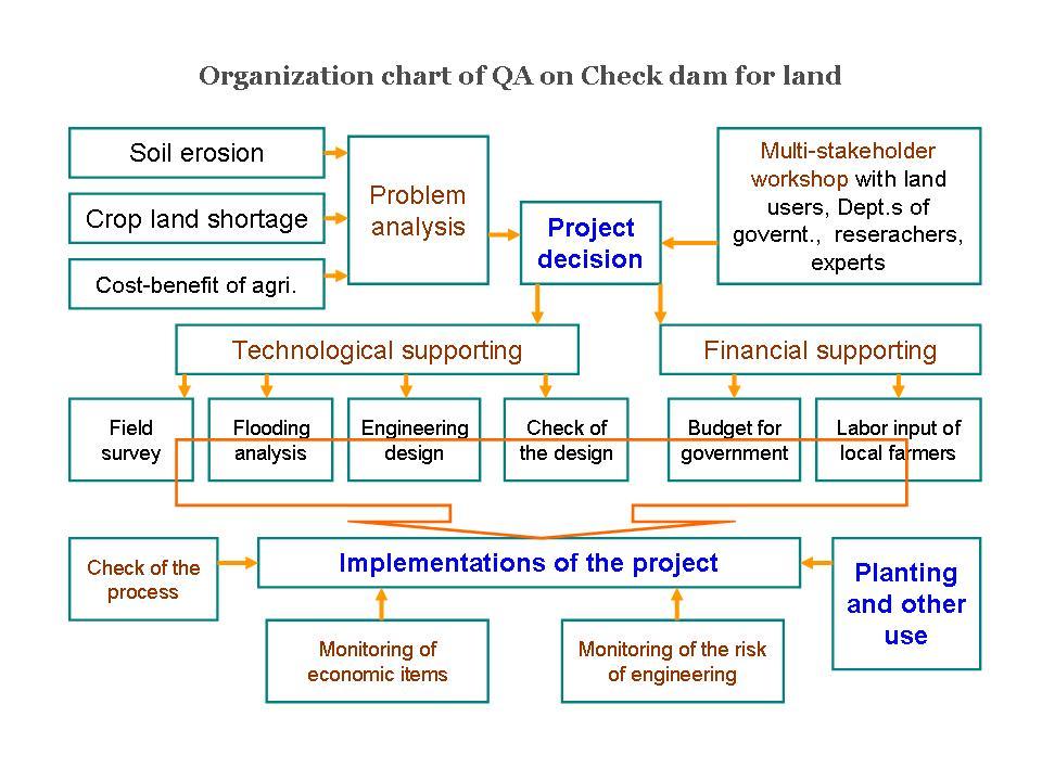
คำอธิบาย:
Organization Chart of check dam land.
ผู้เขียน:
Wang Fei (Yangling, China)
3.4 การตัดสินใจเลือกใช้เทคโนโลยี SLM
ระบุผู้ที่ทำการตัดสินใจเลือกเทคโนโลยีมากกว่าหนึ่งวิธีไปปฏิบัติใช้:
- นักการเมืองหรือผู้นำ
การอธิบาย:
the high input is mainly from the government. Specialist also play a very important role in decision making.
Decisions on the method of implementing the SLM Technology were made by mainly by SLM specialists with consultation of land users. the specialists are the conductor according the natural condition and the requirement of the land users.
4. การสนับสนุนด้านเทคนิค การสร้างขีดความสามารถ และการจัดการด้านความรู้
4.1 การสร้างขีดความสามารถ / การอบรม
ได้มีการจัดอบรมให้แก่ผู้ใช้ที่ดินหรือผู้มีส่วนได้ส่วนเสียคนอื่น ๆ หรือไม่:
ใช่
ให้ระบุว่าใครเป็นผู้ได้รับการอบรม:
- ผู้ใช้ที่ดิน
- เจ้าหน้าที่ภาคสนาม / ที่ปรึกษา
รูปแบบการอบรม:
- ใช้พื้นที่ทำการสาธิต
- จัดการประชุมสู่สาธารณชน
4.2 การบริการให้คำแนะนำ
ผู้ใช้ที่ดินมีการเข้าถึงการรับบริการให้คำปรึกษาหรือไม่:
ใช่
ระบุว่ามีบริการให้คำปรึกษาหรือไม่:
- ไปเยี่ยมชมสถานที่
- ที่ศูนย์ถาวร
การอธิบาย/แสดงความคิดเห็น:
Consultation and Discussion; Key elements: Determine and classify the questions and problems of the project, Analysis the problems and discussion it wth the relative experts, Explain the whole condition of the project to the participants; it is not so difficult in the Loess Plateau because the local farmers are familiar with the check dam for land more or less.
Advisory service is quite adequate to ensure the continuation of land conservation activities; the technology is not new in the Yan River Basin
4.3 การเสริมความแข็งแกร่งให้กับสถาบัน (การพัฒนาองค์กร)
สถาบันได้รับการจัดตั้งขึ้นมาหรือเสริมความแข็งแกร่งโดยแนวทางนี้หรือไม่:
- ใช่ เล็กน้อย
ระบุระดับของสถาบันที่ได้รับการเสริมความแข็งแกร่งหรือจัดตั้งขึ้นมา:
- ท้องถิ่น
ระบุประเภทของการให้ความช่วยเหลือสนับสนุน:
- การสร้างขีดความสามารถ / การอบรม
ให้รายละเอียดเพิ่มเติม :
To show the benefits and process of construction for local farmers.
4.4 การติดตามตรวจสอบและประเมินผล
การติดตามตรวจสอบและประเมินผลเป็นส่วนหนึ่งของแนวทางหรือไม่:
ใช่
ความคิดเห็น:
technical aspects were regular monitored by project staff through measurements; indicators: Professional is necessary in measure and design.
economic / production aspects were regular monitored by project staff, land users through observations; indicators: To know the benefit of project
economic / production aspects were regular monitored by project staff through measurements; indicators: To monitor sometime.
no. of land users involved aspects were regular monitored by government through measurements; indicators: To know how many people participating
management of Approach aspects were regular monitored by government through measurements; indicators: To manage the whole project
There were few changes in the Approach as a result of monitoring and evaluation: the safety of the dam should be checked after flood season in order that the check dam management can be adapted to changing risks.
There were several changes in the Technology as a result of monitoring and evaluation: the sediment from slopes decreased recently, the drainage channel changed to lower level since the stage of designing.
4.5 การวิจัย
การวิจัยเป็นส่วนหนึ่งของแนวทางหรือไม่:
ใช่
ระบุหัวข้อเรื่อง:
- เศรษฐศาสตร์หรือการตลาด
- นิเวศวิทยา
- เทคโนโลยี
ให้ข้อมูลเพิ่มเติมและให้ระบุผู้ทำการวิจัย:
The experts should know the important parameters of the technology for improved designing. The researchers also need to judge and evaluate the permission and support of the project based on the econonic and ecological impacts.
Research was carried out both on station and on-farm
5. การสนับสนุนด้านการเงินและวัสดุอุปกรณ์
5.1 ระบุงบประมาณประจำปีสำหรับแนวทาง SLM นี้
ถ้าหากว่างบประมาณประจำปีไม่เป็นที่ทราบแน่นอน ให้ระบุช่วงลงไป:
- < 2,000
แสดงความคิดเห็น (แหล่งของการระดมทุน ผู้บริจาคคนสำคัญ):
Approach costs were met by the following donors: government (the input is mainly from government): 90.0%; local community / land user(s) (labour work input): 10.0%
5.2 การสนับสนุนด้านการเงิน / วัสดุอุปกรณ์ให้แก่ผู้ใช้ที่ดิน
ผู้ใช้ที่ดินได้รับการสนับสนุนด้านการเงิน / วัสดุอุปกรณ์ไปปฏิบัติใช้เทคโนโลยีหรือไม่:
ใช่
ถ้าใช่ ให้ระบุประเภทของการสนับสนุน เงื่อนไขและผู้จัดหามาให้:
by state
5.3 เงินสนับสนุนสำหรับปัจจัยนำเข้า (รวมถึงแรงงาน)
- อุปกรณ์
| ระบุปัจจัยนำเข้าที่ได้รับการสนับสนุน | เห็นด้วยระดับไหน | ระบุเงินสนับสนุน |
|---|---|---|
| เครื่องจักร | ได้รับการช่วยเหลือทางการเงินแบบเต็ม | by government |
- วัสดุสำหรับการก่อสร้าง
| ระบุปัจจัยนำเข้าที่ได้รับการสนับสนุน | เห็นด้วยระดับไหน | ระบุเงินสนับสนุน |
|---|---|---|
| หิน | ได้รับการช่วยเหลือทางการเงินแบบเต็ม | loess around the site of the dam |
ความคิดเห็น:
The labor input is necessary and some time they can get money from government or other families have no time to participate the construction.
The tools of farmers is very simple.
5.4 เครดิต
มีการจัดหาเครดิตมาให้ภายใต้แนวทาง SLM หรือไม่:
ไม่ใช่
6. การวิเคราะห์ผลกระทบและการสรุป
6.1 ผลกระทบของแนวทาง
ช่วยให้ผู้ใช้ที่ดินนำเอาเทคโนโลยี SLMไปใช้และบำรุงรักษาสภาพไว้ได้หรือไม่:
- ไม่ใช่
- ใช่ เล็กน้อย
- ใช่ ปานกลาง
- ใช่ อย่างมาก
1. the land in the valley is prone to incision by flash flood, the check dam could prevent the erosion; 2. crop land is very useful for the local farmers because of its good condition of soil properities, the local farmers paid more attention to protect this land;3. the ability of production is hig
ทำให้กลุ่มด้อยโอกาสมีอำนาจทางสังคมและเศรษฐกิจหรือไม่:
- ไม่ใช่
- ใช่ เล็กน้อย
- ใช่ ปานกลาง
- ใช่ อย่างมาก
agricultural condition improved so that the yield, income and spare time increases. There are no special changes on gender, age and ethnicity induced by this approach.
ปรับปรุงประเด็นของการถือครองที่ดินหรือสิทธิในการใช้ ซึ่งขัดขวางการนำเทคโนโลยีไปใช้ให้ดีขึ้น:
- ไม่ใช่
- ใช่ เล็กน้อย
- ใช่ ปานกลาง
- ใช่ อย่างมาก
The problem is unlikely to be overcome in the near future. The approach has been approved that the ability of anti-flooding is high. The possible extream storm is out of the consideration till now.
Did other land users / projects adopt the Approach?
- ไม่ใช่
- ใช่ เล็กน้อย
- ใช่ ปานกลาง
- ใช่ อย่างมาก
the Ministry of Water Resources of China developed a project for check dam engineering land based on its the integrated functions. The local government and land users (local farmers) also try to find financial support for this project.
Did the Approach lead to improved livelihoods / human well-being?
- ไม่ใช่
- ใช่ เล็กน้อย
- ใช่ ปานกลาง
- ใช่ อย่างมาก
Stable and high yield, and the relative labor input, of check-dam land could improve livihoods and human well-being; 2. In general cropland land is limited in such an area
Did the Approach help to alleviate poverty?
- ไม่ใช่
- ใช่ เล็กน้อย
- ใช่ ปานกลาง
- ใช่ อย่างมาก
Stable and high yield, and the relative labor input, of check-dam land could improve livihoods and human well-being; 2. In general cropland land is limited in such an area
6.2 แรงจูงใจหลักของผู้ใช้ที่ดินเพื่อที่จะนำ SLM ไปปฏิบัติใช้
- การผลิตที่เพิ่มขึ้น
the yield of the check dam land is stable and high
- ภาระงานลดลง
the labour work less when getting the same food
- well-being and livelihoods improvement
the output of labour is higher
6.3 ความยั่งยืนของกิจกรรมของแนวทาง
ผู้ใช้ที่ดินสามารถทำให้สิ่งต่างๆ ที่ได้ปฏิบัติใช้โดยแนวทางนี้ยั่งยืนได้หรือไม่ (โดยไม่มีการสนับสนุนจากภายนอก):
- ไม่แน่ใจ
ถ้าตอบว่าไม่หรือไม่แน่ใจ ให้ระบุและแสดงความคิดเห็น :
the finicial support of local farmers is limited that makes it impossible to continue, but if the economic condition improved, they might build the check dam for cropland reclamation by themselves.
6.4 จุดแข็งและข้อได้เปรียบของแนวทาง
| จุดแข็ง / ข้อได้เปรียบของแนวทางในทัศนคติของผู้ใช้ที่ดิน |
|---|
| Could get the finicial from government (How to sustain/ enhance this strength: Continue to support the construction at the suitable place) |
| To create 'good' land for themselves (How to sustain/ enhance this strength: Share the land fairly) |
| จุดแข็ง / ข้อได้เปรียบของแนวทางในทัศนคติของผู้รวบรวมหรือวิทยากรหลัก |
|---|
| Make more people know its benefits (How to sustain/ enhance this strength: Show the integrated impacts of project ) |
| Professional design (How to sustain/ enhance this strength: To improve the quanlity of project through field survey and calculation. ) |
| to organize the local farmers working together (How to sustain/ enhance this strength: Plan and make the local farmers to know they can share fairly within the local farmers. ) |
6.5 จุดอ่อน / ข้อเสียเปรียบของแนวทางและวิธีในการแก้ไข
| จุดอ่อน / ข้อเสียเปรียบในทัศนคติของผู้ใช้ที่ดิน | สามารถแก้ไขปัญหาได้อย่างไร |
|---|---|
| very few, sometimes the are is temporary flooded | drainage of the flash water on time |
| จุดอ่อน / ข้อเสียเปรียบในทัศนคติของผู้รวบรวมหรือวิทยากรหลัก | สามารถแก้ไขปัญหาได้อย่างไร |
|---|---|
| change of landform | can not be overcome |
| The farmer does not plan to build check dam for land with their own invest | New approach is necessary for some farmers or small farmer group to implenment project themselves |
7. การอ้างอิงและการเชื่อมต่อ
7.1 วิธีการหรือแหล่งข้อมูล
- ไปเยี่ยมชมภาคสนาม การสำรวจพื้นที่ภาคสนาม
7.2 การอ้างอิงถึงสิ่งตีพิมพ์
ชื่อเรื่อง ผู้เขียน ปี ISBN:
Experiment and Practice of Check Dam Land, Zheng Baoming, Wang Xiao, Tianyonghong, Shangguomei, Mu Zhenlian. 2004
ช่องทางในการสืบค้น และราคา:
Yellow River Conservancy Press【YRCP】
ชื่อเรื่อง ผู้เขียน ปี ISBN:
Effect of soil-retaining dams on flood and sediment reduction in middle reaches of Yellow River. Ran Dachuan, Luo Quanhua, Liu Bin, Wang Hong. 2004
ช่องทางในการสืบค้น และราคา:
JOURNAL OF HYDRAULIC ENGINEERING ,2004, (5)
7.3 เชื่อมโยงกับข้อมูลที่มีอยู่บนออนไลน์
ชื่อเรื่องหรือคำอธิบาย:
Regional Impact of Human Activities on Soil and Water Losses. Wang Fei. PhD thesis, 2004
URL:
http://epub.cnki.net/grid2008/detail.aspx?DBName=CDFD2004&FileName=2004124106.nh
ลิงก์และโมดูล
ขยายทั้งหมด ย่อทั้งหมดลิงก์
Check dam for land [จีน]
Check dam for land is a structural SLM practice that is constructed in the valley of a watershed in order to slow down the runoff and increase sedimentation. After this, the land quality of the controlling area will increase because soil and water conditions in this place are improved.
- ผู้รวบรวม: Fei WANG
โมดูล
ไม่มีโมดูล