Flat Contour Terraces [เยเมน]
- ผู้สร้างสรรค์:
- การอัพเดท:
- ผู้รวบรวม: ahmed algalal
- ผู้เรียบเรียง: –
- ผู้ตรวจสอบ: David Streiff
المدرجات الكنتورية
technologies_1174 - เยเมน
ดูส่วนย่อย
ขยายทั้งหมด ย่อทั้งหมด1. ข้อมูลทั่วไป
1.2 รายละเอียดที่ติดต่อได้ของผู้รวบรวมและองค์กรที่เกี่ยวข้องในการประเมินและการจัดเตรียมทำเอกสารของเทคโนโลยี
ผู้เชี่ยวชาญ SLM:
ผู้เชี่ยวชาญ SLM:
Sallam Ahmed
Agricultural Research and Extension Authority
เยเมน
ชื่อขององค์กรซึ่งอำนวยความสะดวกในการทำเอกสารหรือการประเมินเทคโนโลยี (ถ้าเกี่ยวข้อง)
Agricultural Research and Extension Authority (AREA) - เยเมน1.3 เงื่อนไขการใช้ข้อมูลที่ได้บันทึกผ่านทาง WOCAT
วันที่เก็บรวบรวมข้อมูล(ภาคสนาม) :
07/02/2013
ผู้รวบรวมและวิทยากรหลักยอมรับเงื่อนไขเกี่ยวกับการใช้ข้อมูลที่ถูกบันทึกผ่านทาง WOCAT:
ใช่
1.5 อ้างอิงไปที่แบบสอบถามเรื่องแนวทาง SLM
leveled mountain terraces [เยเมน]
organized collective action at a high pace for building agricultural terraces to improve livelihoods in resource-scarce regions in the ground
- ผู้รวบรวม: ahmed algalal
2. การอธิบายลักษณะของเทคโนโลยี SLM
2.1 การอธิบายแบบสั้น ๆ ของเทคโนโลยี
คำจำกัดความของเทคโนโลยี:
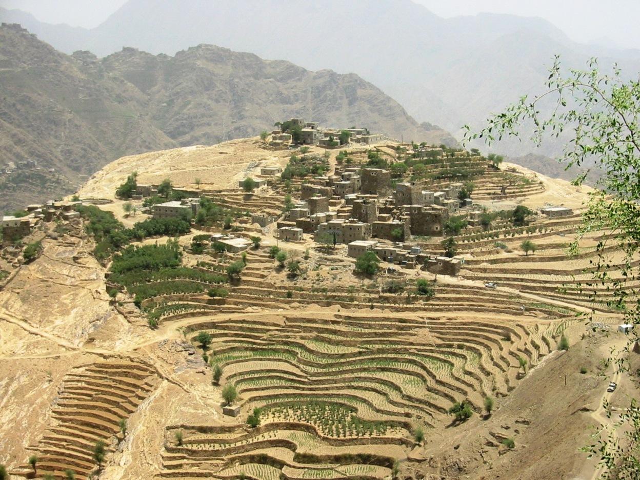
Old flat terraces were built in accordance with the contour lines and surrounded by stones to create a suitable environment for the growth of crops, slope stabilization and reduce the risk of runoff and increasing water harvesting.
2.2 การอธิบายแบบละเอียดของเทคโนโลยี
คำอธิบาย:
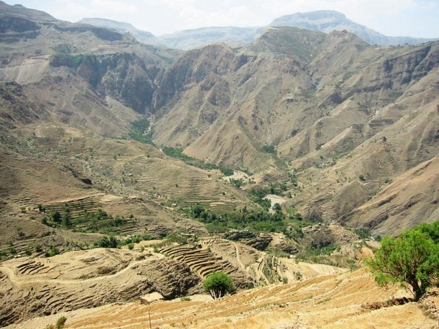
The Yemeni farmer challenged the nature cruel and adopted to cope with the needs and requirements, including the construction of agricultural terraces utilizing all the resources available in the region, where he worked first on the extraction of soil located on the slopes of the mountains and booked by building a wall of stones around where were collected and brought stones from different places. Walls were built in very geometric creativity very well designed so that they work to minimize the risk of soil erosion and increase the use of water runoff without damages to the established terraces so through the construction of terraces along contour lines and making outlets in each terrace to drain excess water.
The process of building terraces using stones according to the contours, which works to prevent soil erosion and erosion, as well as help to increase soil moisture as a result harvest runoff, which leads to meet the needs of crop water and thereby increase production.
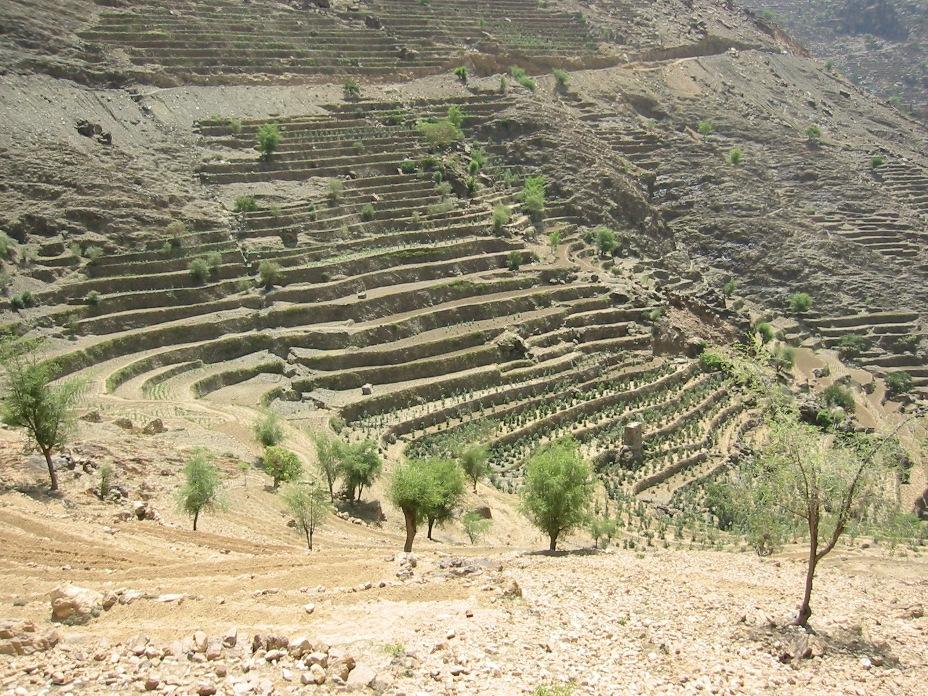
The main objective of building terraces is to increase production. The soil depth at the beginning of the establishment of the stands to be very shallow and increasing soil depth as a result of increasing deposits the soil.This process is booked by increasing the height of the wall that range between 1-3 meters, and a width runway between 1-6 meters As for the length of the runway It is 5 - 80 meters according to the contour line, which runs on reserve deposits and protect the soil from erosion.. Finally terraces are planted with annual crops mainly cereals crops, as well as perennial trees such as coffee, diamond, Qat and other perennial trees.
The terraces of the projects long-term where you need a long time to build due to the use of hands in the construction process as a result you cannot use the mechanisms, for maintenance operations in view of the building stands on the regions of steep and where the rate of runoff high result of heavy rains in a short time in addition to Regression factor that leads to increase the speed of the flow of water, which operate on a cliff erosion terraces in the event of lack of maintenance, which makes the process of ongoing maintenance is an urgent need to ensure the preservation and sustainability of the stands.
2.3 รูปภาพของเทคโนโลยี
อัลบั้มสื่อบันทึก
2.5 ประเทศภูมิภาค หรือสถานที่ตั้งที่เทคโนโลยีได้นำไปใช้และได้รับการครอบคลุมโดยการประเมินนี้
ประเทศ:
เยเมน
ภูมิภาค/รัฐ/จังหวัด:
Hajah Governorate
ข้อมูลจำเพาะเพิ่มเติมของสถานที่ตั้ง :
Kahlan Afar

Map
×2.6 วันที่การดำเนินการ
ถ้าไม่รู้ปีที่แน่นอน ให้ระบุวันที่โดยประมาณ:
- มากกว่า 50 ปี (แบบดั้งเดิม)
2.7 คำแนะนำของเทคโนโลยี
ให้ระบุว่าเทคโนโลยีถูกแนะนำเข้ามาอย่างไร:
- เป็นส่วนหนึ่งของระบบแบบดั้งเดิมที่ทำก้นอยู่ (> 50 ปี)
ความคิดเห็น (ประเภทของโครงการ เป็นต้น) :
too old since approximately 2000 BC
3. การจัดประเภทของเทคโนโลยี SLM
3.1 วัตถุประสงค์หลักของเทคโนโลยี
- ปรับปรุงการผลิตให้ดีขึ้น
- ลด ป้องกัน ฟื้นฟู การเสื่อมโทรมของที่ดิน
3.2 ประเภทของการใช้ที่ดินในปัจจุบันที่ได้นำเทคโนโลยีไปใช้

พื้นที่ปลูกพืช
- การปลูกพืชล้มลุกอายุปีเดียว
- การปลูกไม้ยืนต้น ไม้พุ่ม
พืชหลัก (พืชเศรษฐกิจและพืชอาหาร):
major cash crop: Coffee and Qat
major food crop: Corn, wheat, barley, lentils and beans
แสดงความคิดเห็น:
Major land use problems (compiler’s opinion): severe slopes that works to increase the speed of runoff, which leads to soil loss
3.3 ข้อมูลเพิ่มเติมเกี่ยวกับการใช้ที่ดิน
การใช้น้ำของที่ดินที่มีการใช้เทคโนโลยีอยู่:
- จากน้ำฝน
แสดงความคิดเห็น:
Also mixed rainfed - irrigated
จำนวนของฤดูเพาะปลูกต่อปี:
- 2
ระบุ:
Longest growing period in days: 240
3.4 กลุ่ม SLM ที่ตรงกับเทคโนโลยีนี้
- มาตรการปลูกพืชขวางความลาดชัน (cross-slope measure)
3.5 กระจายตัวของเทคโนโลยี
ระบุการกระจายตัวของเทคโนโลยี:
- กระจายไปอย่างสม่ำเสมอในพื้นที่
แสดงความคิดเห็น:
Total area covered by the SLM Technology is 5.4 km2.
The study area is located in the south west of Fort Kahlan Afar and stretches along the projected water severe slope, and include seven villages spreading from the highest peak of the mountain until the bottom of the valley respectively: Bait guardian, Al Qimmeh, Bait Al Farawi, Al-ubal, Fara'ah, Bani Bram , Wadi (Valley) EabrHajr.
3.6 มาตรการ SLM ที่ประกอบกันเป็นเทคโนโลยี

มาตรการจัดการพืช
- A3: การรักษาหน้าดิน

มาตรการอนุรักษ์ด้วยโครงสร้าง
- S1: คันดิน
แสดงความคิดเห็น:
Secondary measures: agronomic measures
Type of agronomic measures: contour tillage
3.7 รูปแบบหลักของการเสื่อมโทรมของที่ดินที่ได้รับการแก้ไขโดยเทคโนโลยี

การกัดกร่อนของดินโดยน้ำ
- Wt (Loss of topsoil): การสูญเสียดินชั้นบนหรือการกัดกร่อนที่ผิวดิน
- Wg (Gully erosion): การกัดกร่อนแบบร่องธารหรือการทำให้เกิดร่องน้ำเซาะ

การเสื่อมโทรมของดินทางด้านชีวภาพ
- Bc (Reduction of vegetation cover): การลดลงของจำนวนพืชที่ปกคลุมดิน

การเสื่อมโทรมของน้ำ
- Ha (Aridification): การเกิดความแห้งแล้ง
แสดงความคิดเห็น:
Secondary types of degradation addressed: Bc: reduction of vegetation cover, Ha: aridification
Main causes of degradation: over-exploitation of vegetation for domestic use, Heavy / extreme rainfall (intensity/amounts) (severe rainfall in a short time), other natural causes (avalanches, volcanic eruptions, mud flows, highly susceptible natural resources, extreme topography, etc.) specify (severe slopes)
Secondary causes of degradation: overgrazing, droughts (As a result of the fluctuation of rainfall), poverty / wealth (Poverty)
3.8 การป้องกัน การลดลง หรือการฟื้นฟูความเสื่อมโทรมของที่ดิน
ระบุเป้าหมายของเทคโนโลยีกับความเสื่อมโทรมของที่ดิน:
- ลดความเสื่อมโทรมของดิน
4. ข้อมูลจำเพาะด้านเทคนิค กิจกรรมการนำไปปฏิบัติใช้ ปัจจัยนำเข้า และค่าใช้จ่าย
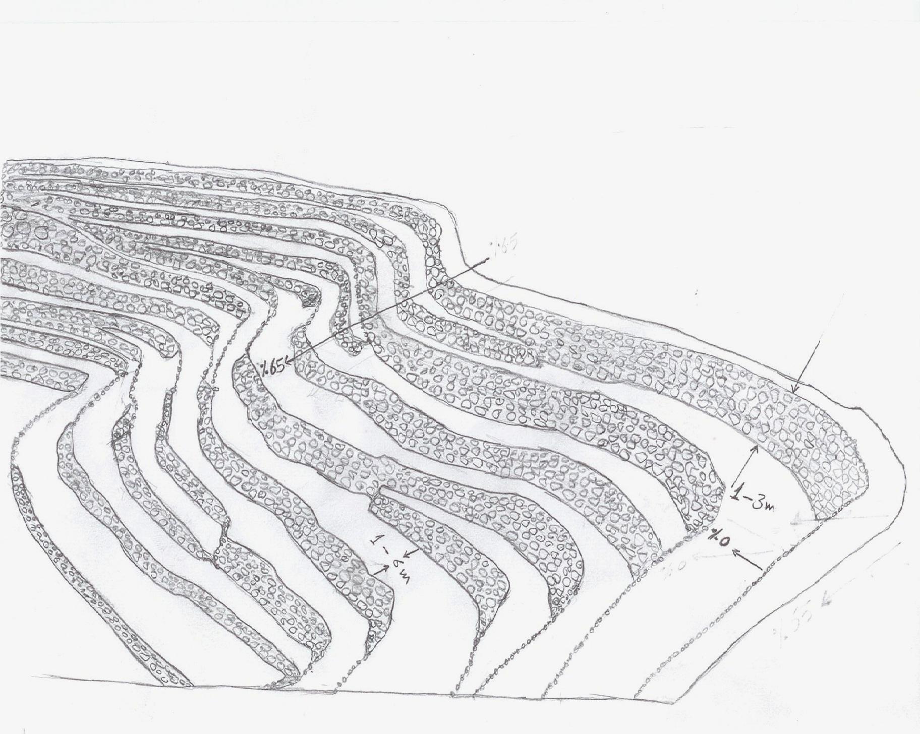
4.1 แบบแปลนทางเทคนิคของเทคโนโลยี
ผู้เขียน:
Algalal
4.2 ข้อมูลจำเพาะด้านเทคนิคและการอธิบายแบบแปลนทางเทคนิค
terraces built along contour lines
Location: Hajah Governorate. Kahlan Afer
Date: 10-2-2013
Technical knowledge required for field staff / advisors: moderate (does not have only a little experience)
Technical knowledge required for land users: low (Has enough experience)
Main technical functions: reduction of slope angle, reduction of slope length, water harvesting / increase water supply, sediment retention / trapping, sediment harvesting, reduction surface runoff
Secondary technical functions: increase of infiltration, water spreading
Contour tillage
Material/ species: agricultural tools, animal traction
Terrace: bench level
Vertical interval between structures (m): 1 - 3
Spacing between structures (m): 1 - 6
Height of bunds/banks/others (m): 1 - 3
Width of bunds/banks/others (m): 1 - 6
Length of bunds/banks/others (m): 5 - 80
Construction material (earth): Collecting soil and reserve deposits to increase the soil depth
Construction material (stone): Stones available in the region
Slope (which determines the spacing indicated above): 65%
If the original slope has changed as a result of the Technology, the slope today is: 0%
Lateral gradient along the structure: 0%
For water harvesting: the ratio between the area where the harvested water is applied and the total area from which water is collected is: 1:1
4.3 ข้อมูลทั่วไปเกี่ยวกับการคำนวณปัจจัยนำเข้าและค่าใช้จ่าย
ระบุสกุลเงินที่ใช้คำนวณค่าใช้จ่าย:
- ดอลลาร์สหรัฐ
ระบุค่าเฉลี่ยของค่าจ้างในการจ้างแรงงานต่อวัน:
7.00
4.4 กิจกรรมเพื่อการจัดตั้ง
| กิจกรรม | ประเภทของมาตรการ | ช่วงเวลาดำเนินการ | |
|---|---|---|---|
| 1. | Extraction of soil | ด้วยโครงสร้าง | Before the rainy season |
| 2. | Collecting stones | ด้วยโครงสร้าง | Before the rainy season |
| 3. | Build a wall to establish a terrace | ด้วยโครงสร้าง | Before the rainy season |
4.5 ค่าใช้จ่ายของปัจจัยนำเข้าที่จำเป็นสำหรับการจัดตั้ง
| ปัจจัยนำเข้า | หน่วย | ปริมาณ | ค่าใช้จ่ายต่อหน่วย | ค่าใช้จ่ายทั้งหมดต่อปัจจัยนำเข้า | %ของค่าใช้จ่ายที่ก่อให้เกิดขึ้นโดยผู้ใช้ที่ดิน | |
|---|---|---|---|---|---|---|
| แรงงาน | Extraction of soil | ha | 1.0 | 2500.0 | 2500.0 | 100.0 |
| แรงงาน | Collecting stones | ha | 1.0 | 1162.8 | 1162.8 | 100.0 |
| แรงงาน | Build a wall to establish a terrace | ha | 1.0 | 558.0 | 558.0 | 100.0 |
| อุปกรณ์ | Tools | ha | 1.0 | 46.5 | 46.5 | 100.0 |
| อุปกรณ์ | Animal traction | ha | 1.0 | 186.0 | 186.0 | 100.0 |
| ค่าใช้จ่ายทั้งหมดของการจัดตั้งเทคโนโลยี | 4453.3 | |||||
แสดงความคิดเห็น:
Duration of establishment phase: 12 month(s)
4.6 การบำรุงรักษาสภาพหรือกิจกรรมที่เกิดขึ้นเป็นประจำ
| กิจกรรม | ประเภทของมาตรการ | ช่วงระยะเวลา/ความถี่ | |
|---|---|---|---|
| 1. | plowing along contour lines | จัดการพืช | Before planting |
| 2. | Repairing damaged walls | ด้วยโครงสร้าง | annually after the rain |
4.7 ค่าใช้จ่ายของปัจจัยนำเข้าและกิจกรรมที่เกิดขึ้นเป็นประจำที่ต้องการการบำรุงรักษา (ต่อปี)
| ปัจจัยนำเข้า | หน่วย | ปริมาณ | ค่าใช้จ่ายต่อหน่วย | ค่าใช้จ่ายทั้งหมดต่อปัจจัยนำเข้า | %ของค่าใช้จ่ายที่ก่อให้เกิดขึ้นโดยผู้ใช้ที่ดิน | |
|---|---|---|---|---|---|---|
| แรงงาน | Plowing along contour lines | ha | 1.0 | 50.0 | 50.0 | 100.0 |
| แรงงาน | Repairing damaged walls | ha | 1.0 | 100.0 | 100.0 | 100.0 |
| อุปกรณ์ | Tools | ha | 1.0 | 30.0 | 30.0 | 100.0 |
| อุปกรณ์ | Animal traction | ha | 1.0 | 50.0 | 50.0 | 100.0 |
| อุปกรณ์ | Tools | ha | 1.0 | 18.6 | 18.6 | 100.0 |
| ค่าใช้จ่ายทั้งหมดของการบำรุงรักษาสภาพเทคโนโลยี | 248.6 | |||||
แสดงความคิดเห็น:
Machinery/ tools: Shovel, local plow and a leveler, Shovel, Big hammer
calculated costs an average length of 60 meters along the wall stone and rising 2.5 meters. other operations were calculated per hectare considering that the land users who will carry the implemented works. with respect to maintenance has been calculated taking into account the fact that the stands terraces are considered investments long term and not subject to erosion annually, but in the event of a severe rain storm.
4.8 ปัจจัยสำคัญที่สุดที่มีผลกระทบต่อค่าใช้จ่าย
ปัจจัยสำคัญที่สุดที่มีผลกระทบต่อค่าใช้จ่ายต่างๆ:
Collecting and transporting stones
Severe slopes
5. สิ่งแวดล้อมทางธรรมชาติและของมนุษย์
5.1 ภูมิอากาศ
ฝนประจำปี
- < 250 ม.ม.
- 251-500 ม.ม.
- 501-750 ม.ม.
- 751-1,000 ม.ม.
- 1,001-1,500 ม.ม.
- 1,501-2,000 ม.ม.
- 2,001-3,000 ม.ม.
- 3,001-4,000 ม.ม.
- > 4,000 ม.ม.
เขตภูมิอากาศเกษตร
- กึ่งชุ่มชื้น
- กึ่งแห้งแล้ง
Thermal climate class: temperate
5.2 สภาพภูมิประเทศ
ค่าเฉลี่ยความลาดชัน:
- ราบเรียบ (0-2%)
- ลาดที่ไม่ชัน (3-5%)
- ปานกลาง (6-10%)
- เป็นลูกคลื่น (11-15%)
- เป็นเนิน (16-30%)
- ชัน (31-60%)
- ชันมาก (>60%)
ธรณีสัณฐาน:
- ที่ราบสูง/ที่ราบ
- สันเขา
- ไหล่เขา
- ไหล่เนินเขา
- ตีนเนิน
- หุบเขา
ระดับความสูง:
- 0-100 เมตร
- 101-500 เมตร
- 501-1,000 เมตร
- 1,001-1,500 เมตร
- 1,501-2,000 เมตร
- 2,001-2,500 เมตร
- 2,501-3,000 เมตร
- 3,001-4,000 เมตร
- > 4,000 เมตร
ให้ระบุถ้าเทคโนโลยีได้ถูกนำไปใช้:
- บริเวณสันเขา (convex situations)
ความคิดเห็นและข้อมูลจำเพาะเพิ่มเติมเรื่องสภาพภูมิประเทศ:
Slopes on average: 30-80%
Altitudinal zone: 1600- 2700 m a.s.l.
5.3 ดิน
ค่าเฉลี่ยความลึกของดิน:
- ตื้นมาก (0-20 ซ.ม.)
- ตื้น (21-50 ซ.ม.)
- ลึกปานกลาง (51-80 ซ.ม.)
- ลึก (81-120 ซ.ม.)
- ลึกมาก (>120 ซ.ม.)
เนื้อดิน (ดินชั้นบน):
- ปานกลาง (ดินร่วน ทรายแป้ง)
- ละเอียด/หนัก (ดินเหนียว)
อินทรียวัตถุในดิน:
- ต่ำ (<1%)
(ถ้ามี) ให้แนบคำอธิบายเรื่องดินแบบเต็มหรือระบุข้อมูลที่มีอยู่ เช่น ชนิดของดิน ค่า pH ของดินหรือความเป็นกรดของดิน ความสามารถในการแลกเปลี่ยนประจุบวก ไนโตรเจน ความเค็ม เป็นต้น:
Soil texture (topsoil): Silty Clay loam
Soil fertility is very low
Soil drainage / infiltration is medium - good
Soil water storage capacity is high
5.4 ความเป็นประโยชน์และคุณภาพของน้ำ
คุณภาพน้ำ (ที่ยังไม่ได้บำบัด):
เป็นน้ำเพื่อการดื่มที่ดี
5.5 ความหลากหลายทางชีวภาพ
ความหลากหลายทางชนิดพันธุ์:
- ต่ำ
5.6 ลักษณะของผู้ใช้ที่ดินที่นำเทคโนโลยีไปปฏิบัติใช้
แนวทางการตลาดของระบบการผลิต:
- เพื่อการยังชีพ (หาเลี้ยงตนเอง)
- ผสม (การเลี้ยงชีพ/ทำการค้า)
รายได้ที่มาจากนอกฟาร์ม:
- < 10% ของรายได้ทั้งหมด
ระดับของความมั่งคั่งโดยเปรียบเทียบ:
- ยากจนมาก
- จน
เป็นรายบุคคล/ครัวเรือน:
- เป็นรายบุคคล/ครัวเรือน
ระดับของการใช้เครื่องจักรกล:
- งานที่ใช้แรงกาย
- การใช้กำลังจากสัตว์
เพศ:
- ชาย
ระบุลักษณะอื่นๆที่เกี่ยวข้องของผู้ใช้ที่ดิน:
Land users applying the Technology are mainly common / average land users
Difference in the involvement of women and men: physically women to carry hard work, so the man who does the work on the farm and women are household.
Population density: 200-500 persons/km2
Annual population growth: 3% - 4%
20% of the land users are average wealthy and own 30% of the land.
65% of the land users are poor and own 50% of the land.
15% of the land users are poor and own 20% of the land.
5.7 พื้นที่เฉลี่ยของที่ดินที่เป็นเจ้าของหรือเช่าโดยผู้ใช้ที่ดินที่นำเทคโนโลยีไปปฏิบัติใช้
- < 0.5 เฮกตาร์
- 0.5-1 เฮกตาร์
- 1-2 เฮกตาร์
- 2-5 เฮกตาร์
- 5-15 เฮกตาร์
- 15-50 เฮกตาร์
- 50-100 เฮกตาร์
- 100-500 เฮกตาร์
- 500-1,000 เฮกตาร์
- 1,000-10,000 เฮกตาร์
- >10,000 เฮกตาร์
พิจารณาว่าเป็นขนาดเล็ก กลาง หรือขนาดใหญ่ (ซึ่งอ้างอิงถึงบริบทระดับท้องถิ่น):
- ขนาดกลาง
แสดงความคิดเห็น:
The average land tenure of between 0.5 - 2 hectares
5.8 กรรมสิทธิ์ในที่ดิน สิทธิในการใช้ที่ดินและสิทธิในการใช้น้ำ
กรรมสิทธิ์ในที่ดิน:
- รายบุคคล ได้รับสิทธิครอบครอง
สิทธิในการใช้ที่ดิน:
- เช่า
- รายบุคคล
- Waqf
สิทธิในการใช้น้ำ:
- เกี่ยวกับชุมชน (ถูกจัดระเบียบ)
- Waqf
แสดงความคิดเห็น:
There are three types of land ownership owned, hired and Waqf by 74%, 19%, 7%, respectively.
5.9 การเข้าถึงบริการและโครงสร้างพื้นฐาน
สุขภาพ:
- จน
- ปานกลาง
- ดี
การศึกษา:
- จน
- ปานกลาง
- ดี
ความช่วยเหลือทางด้านเทคนิค:
- จน
- ปานกลาง
- ดี
การจ้างงาน (เช่น ภายนอกฟาร์ม):
- จน
- ปานกลาง
- ดี
ตลาด:
- จน
- ปานกลาง
- ดี
พลังงาน:
- จน
- ปานกลาง
- ดี
ถนนและการขนส่ง:
- จน
- ปานกลาง
- ดี
น้ำดื่มและการสุขาภิบาล:
- จน
- ปานกลาง
- ดี
บริการด้านการเงิน:
- จน
- ปานกลาง
- ดี
6. ผลกระทบและสรุปคำบอกกล่าว
6.1 ผลกระทบในพื้นที่ดำเนินการ (On-site) จากการใช้เทคโนโลยี
ผลกระทบทางด้านเศรษฐกิจและสังคม
การผลิต
การผลิตพืชผล
การผลิตพืชที่ใช้เลี้ยงปศุสัตว์
การเสี่ยงต่อความล้มเหลวในการผลิต
พื้นที่สำหรับการผลิต
การจัดการที่ดิน
ความเป็นประโยชน์และคุณภาพของน้ำ
การมีน้ำดื่มไว้ให้ใช้
แสดงความคิดเห็น/ระบุ:
As a result of the infiltration process
รายได้และค่าใช้จ่าย
รายได้จากฟาร์ม
ภาระงาน
ผลกระทบด้านสังคมวัฒนธรรมอื่น ๆ
ความมั่นคงด้านอาหาร / พึ่งตนเองได้
โอกาสทางวัฒนธรรม
SLM หรือความรู้เรื่องความเสื่อมโทรมของที่ดิน
livelihood and human well-being
ผลกระทบด้านนิเวศวิทยา
วัฐจักรน้ำหรือน้ำบ่า
ปริมาณน้ำ
การเก็บเกี่ยวหรือการกักเก็บน้ำ
น้ำไหลบ่าที่ผิวดิน
การระบายน้ำส่วนเกิน
น้ำบาดาลหรือระดับน้ำในแอ่งน้ำบาดาล
ดิน
ความชื้นในดิน
การสูญเสียดิน
ความหลากหลายทางชีวภาพของพืชและสัตว์
ความหลากหลายทางชีวภาพของพืช
ความหลากหลายของสัตว์
6.2 ผลกระทบนอกพื้นที่ดำเนินการ (Off-site) จากการใช้เทคโนโลยี
น้ำที่ใช้ประโยชน์ได้
น้ำท่วมพื้นที่ท้ายน้ำ
การทับถมของดินตะกอนพื้นที่ท้ายน้ำ
แสดงความคิดเห็น/ระบุ:
reduction of sediments
6.3 การเผชิญและความตอบสนองของเทคโนโลยีต่อการเปลี่ยนแปลงสภาพภูมิอากาศที่ค่อยเป็นค่อยไป และสภาพรุนแรงของภูมิอากาศ / ภัยพิบัติ (ที่รับรู้ได้โดยผู้ใช้ที่ดิน)
การเปลี่ยนแปลงสภาพภูมิอากาศที่ค่อยเป็นค่อยไป
การเปลี่ยนแปลงสภาพภูมิอากาศที่ค่อยเป็นค่อยไป
| ฤดู | ประเภทของการเปลี่ยนแปลงสภาพภูมิอากาศที่ค่อยเป็นค่อยไป และสภาพรุนแรงของภูมิอากาศ | เทคโนโลยีมีวิธีการรับมืออย่างไร | |
|---|---|---|---|
| อุณหภูมิประจำปี | เพิ่มขึ้น | ดี |
สภาพรุนแรงของภูมิอากาศ (ภัยพิบัติ)
ภัยพิบัติทางอุตุนิยมวิทยา
| เทคโนโลยีมีวิธีการรับมืออย่างไร | |
|---|---|
| พายุฝนประจำท้องถิ่น | ไม่ค่อยดี |
6.4 การวิเคราะห์ค่าใช้จ่ายและผลประโยชน์ที่ได้รับ
ผลประโยชน์ที่ได้รับเปรียบเทียบกับค่าใช้จ่ายในการจัดตั้งเป็นอย่างไร (จากมุมมองของผู้ใช้ที่ดิน)
ผลตอบแทนระยะสั้น:
ด้านลบเล็กน้อย
ผลตอบแทนระยะยาว:
ด้านบวก
ผลประโยชน์ที่ได้รับเปรียบเทียบกับค่าใช้จ่ายในการบำรุงรักษาหรือต้นทุนที่เกิดขึ้นซ้ำอีก เป็นอย่างไร (จากมุมมองของผู้ใช้ที่ดิน)
ผลตอบแทนระยะสั้น:
ด้านบวก
ผลตอบแทนระยะยาว:
ด้านบวกอย่างมาก
6.5 การปรับตัวของเทคโนโลยี
- มากกว่า 50%
ถ้ามีข้อมูลให้บอกปริมาณด้วย (จำนวนของครัวเรือนหรือครอบคลุมพื้นที่):
994 households covering 100 percent of stated area
จากทั้งหมดที่ได้รับเทคโนโลยีเข้ามามีจำนวนเท่าใดที่ทำแบบทันที โดยไม่ได้รับการจูงใจด้านวัสดุหรือการเงินใด ๆ:
- 90-100%
แสดงความคิดเห็น:
994 land user families have adopted the Technology without any external material support
There is a little trend towards spontaneous adoption of the Technology
Comments on adoption trend: because the technology is adopted in the whole Yemen, but there is difficulty with regard to the sustainability of technical maintenance due to lack of financial resources and poverty which leads to migration and lack of interest in the land
6.7 จุดแข็ง / ข้อได้เปรียบ / โอกาสของเทคโนโลยี
| จุดแข็ง / ข้อได้เปรียบ / โอกาสในทัศนคติของผู้รวบรวมหรือวิทยากรหลัก |
|---|
|
Creating a suitable environment for the growth of various crops How can they be sustained / enhanced? continue the process of maintenance to maintain walls and outlets |
|
Water harvesting to increase soil moisture How can they be sustained / enhanced? maintenance of water outlet constantly ensure that no water erosion by allowing excess water to drain out through the outlets. |
|
reduce runoff and Prevention of soil erosion How can they be sustained / enhanced? ongoing maintenance of outlets. |
|
discharge excess water in a systematic manner How can they be sustained / enhanced? ongoing maintenance of water exits |
|
reduce the length and angle of the slope How can they be sustained / enhanced? Maintaining the terraces |
6.8 จุดอ่อน / ข้อเสียเปรียบ / ความเสี่ยงของเทคโนโลยีและวิธีการแก้ไข
| จุดอ่อน / ข้อเสียเปรียบ / ความเสี่ยงในทัศนคติของผู้รวบรวมหรือวิทยากรหลัก | มีวิธีการแก้ไขได้อย่างไร |
|---|---|
| Low productivity in the first years of the Created stands terraces due to poor soil fertility and lack of depth | apply fertilizer and chemical and organic fertilizers |
| In the event of very heavy rain may be susceptible to erosion terraces | ongoing maintenance of the waterways and channels to ensure that no diversion of water to areas prone to erosion and maintenance of the walls of the terraces and drain excess water. |
| Due to the construction of terraces on the hillsides with steep slopes, which makes it difficult to use farm machinery and agricultural work is done by hand, which requires many labor somewhat | the search for new technologies that fit this purpose |
7. การอ้างอิงและการเชื่อมต่อ
7.2 การอ้างอิงถึงสิ่งตีพิมพ์
หัวข้อ, ผู้เขียน, ปี, หมายเลข ISBN:
Mountain terraces study in the Kahlan Afar region (Mashreqi, et, al 2003)- 44. General Census of Population, Housing and Establishment (Census, 2004).- 45. Guide of agricultural climate in Yemen (Al Khorasani, 2005).
ชื่อเรื่อง ผู้เขียน ปี ISBN:
Agricultural Research and Extension Authority, AREA Central Bureau of Statistics.Agricultural Research and Extension Authority, AREA
ลิงก์และโมดูล
ขยายทั้งหมด ย่อทั้งหมดลิงก์
leveled mountain terraces [เยเมน]
organized collective action at a high pace for building agricultural terraces to improve livelihoods in resource-scarce regions in the ground
- ผู้รวบรวม: ahmed algalal
โมดูล
ไม่มีโมดูล