Gully erosion management [เอธิโอเปีย]
- ผู้สร้างสรรค์:
- การอัพเดท:
- ผู้รวบรวม: Gizaw Desta Gessesse
- ผู้เรียบเรียง: –
- ผู้ตรวจสอบ: Deborah Niggli
Borebore lemat (Amharic)
technologies_1597 - เอธิโอเปีย
ดูส่วนย่อย
ขยายทั้งหมด ย่อทั้งหมด1. ข้อมูลทั่วไป
1.2 รายละเอียดที่ติดต่อได้ของผู้รวบรวมและองค์กรที่เกี่ยวข้องในการประเมินและการจัดเตรียมทำเอกสารของเทคโนโลยี
ผู้เชี่ยวชาญ SLM:
Bekure Melese
WLRC
ชื่อของโครงการซึ่งอำนวยความสะดวกในการทำเอกสารหรือการประเมินเทคโนโลยี (ถ้าเกี่ยวข้อง)
Water and Land Resource Centre Project (WLRC)1.3 เงื่อนไขการใช้ข้อมูลที่ได้บันทึกผ่านทาง WOCAT
ผู้รวบรวมและวิทยากรหลักยอมรับเงื่อนไขเกี่ยวกับการใช้ข้อมูลที่ถูกบันทึกผ่านทาง WOCAT:
ใช่
1.4 การเปิดเผยเรื่องความยั่งยืนของเทคโนโลยีที่ได้อธิบายไว้
เทคโนโลยีที่ได้อธิบายไว้นี้เป็นปัญหาของความเสื่อมโทรมโทรมของที่ดินหรือไม่ จึงไม่ได้รับการยอมรับว่าเป็นเทคโนโลยีเพื่อการจัดการที่ดินอย่างยั่งยืน:
ไม่ใช่
1.5 อ้างอิงไปที่แบบสอบถามเรื่องแนวทาง SLM
Community Organizations and Mobilization for Soil and Water … [เอธิโอเปีย]
Community mobilization for soil and water conservation work in a watershed planning unit is an approach for collective action by organizing all active labor forces living in the kebele/peasant association into development group of 20-30 members and further divide into 1:5 work force to implement construction of soil and water …
- ผู้รวบรวม: Gizaw Desta Gessesse
'Cut and Carry' Grazing system or 'Zero Grazing' … [เอธิโอเปีย]
Cut and carry grazing system (alternatively called zero grazing) is an approach where the community is consulted to identify and agree on areas to be closed and protected from free grazing; establish user groups are established to share the fodder biomass harvested from communal closed areas equitably; they utilize tree/shrub …
- ผู้รวบรวม: Gizaw Desta Gessesse
2. การอธิบายลักษณะของเทคโนโลยี SLM
2.1 การอธิบายแบบสั้น ๆ ของเทคโนโลยี
คำจำกัดความของเทคโนโลยี:
Gully erosion management is the application of combination of practices to control excess or concentrated runoff generation in the gully upstream catchment area, divert excess runoff upstream of gully heads and control further development of gully using appropriate structural and vegetative measures in the head, bed and sides of the gully and eventually convert into productive land through the consultation and involvement of local community.
2.2 การอธิบายแบบละเอียดของเทคโนโลยี
คำอธิบาย:
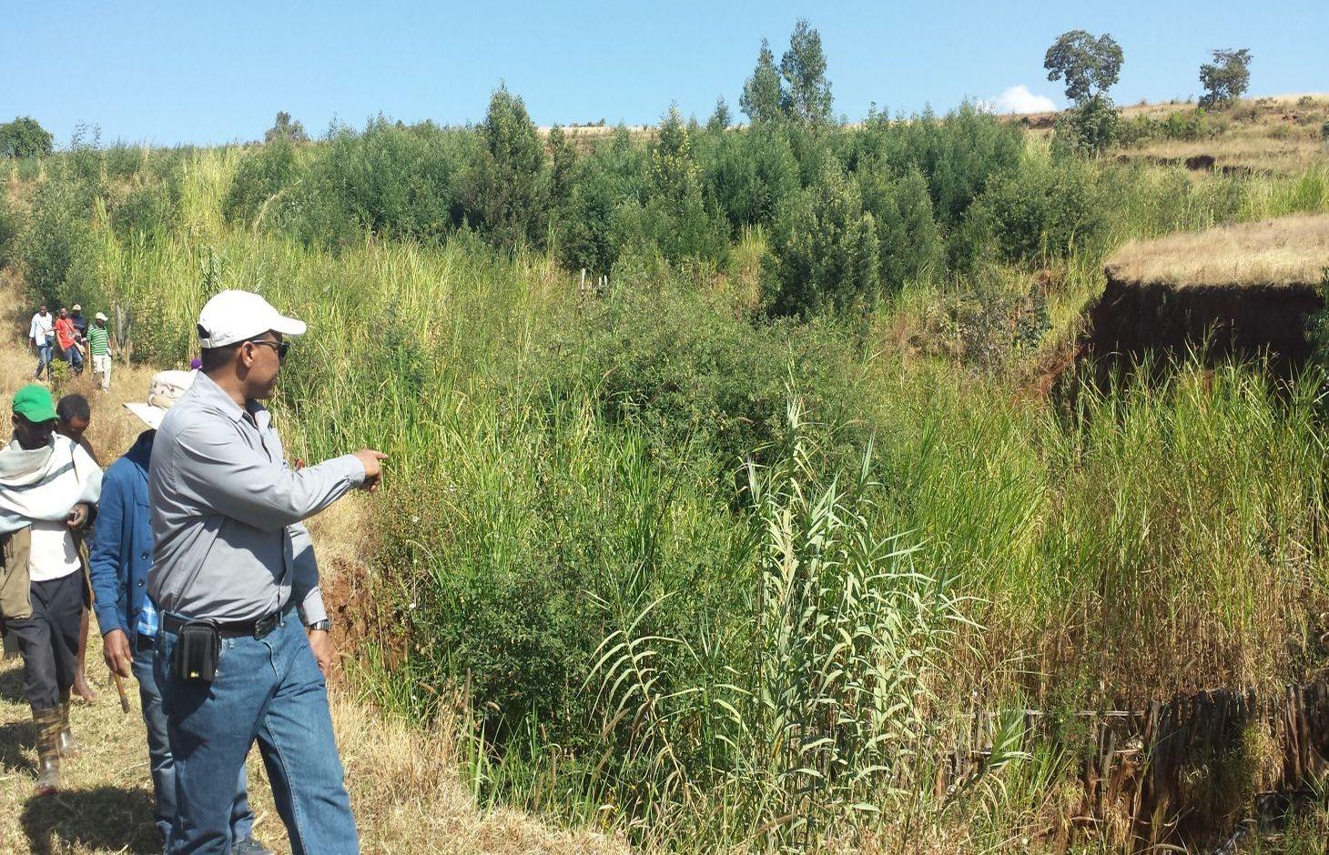
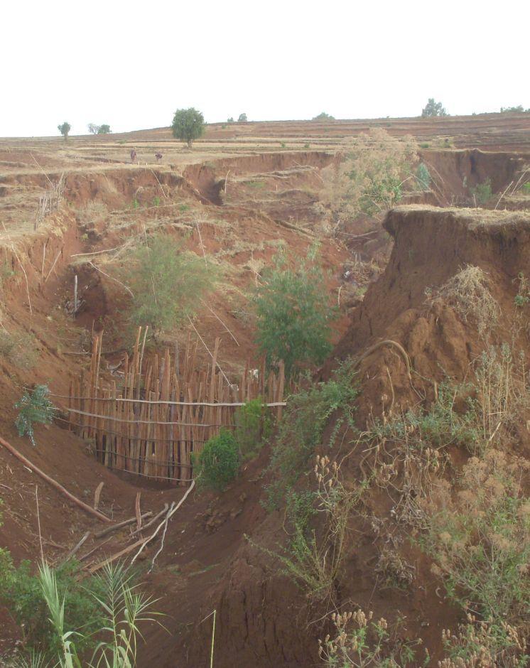
Gully erosion occurs on cultivated and grazing/pasture lands. Gully erosion management is a practice aimed to rehabilitate and protect further development of gullies and change into productive land. It involves both runoff management and erosion control activities. Gully management and treatment is different at upstream catchment area, gully head and gully section. Proper land management practices and slope treatment measures such as terraces, infiltration ditches and grass or shrub hedgerows are taking place on upstream catchment of the gully in order to reduce the rate of surface runoff. The excess runoff above the gully head is safely drained using cutoff drains into natural or properly vegetated waterways in order to reduce the surface water entering into the gully and protect the constructed physical and biological measures being washed away. Before treating gully sections, for the purpose of stability of structures and quick healing, the gully should be reshaped and planted with grass sod. Gully wall reshaping is cutting off steep slopes of active gully flanks in to gentle slope of minimum at 45% slope, up to two-third of the total depth of the gully and constructing small trenches along contours for re-vegetating slanted part of the gully walls and beds. If the gully is wide and has meandering nature with huge accumulation of runoff flowing down, it requires constructing of retaining walls, to protect displaced (not yet stabilized) soils and soil materials and the sidewalls of the reshaped gully. Stabilization of gully sections involves the use of structural and vegetative measures in the head, floor and side of the gully. The construction of physical structures inside the gully section is followed by establishment of biological measures.
Purposes of gully erosion management are: 1) rehabilitate the land damaged due to gully erosion, 2) prevent further expansion and development of gully erosion, and 3) convert the land lost by gully erosion to productive land.
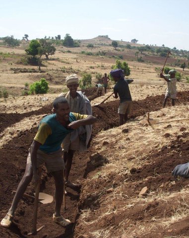
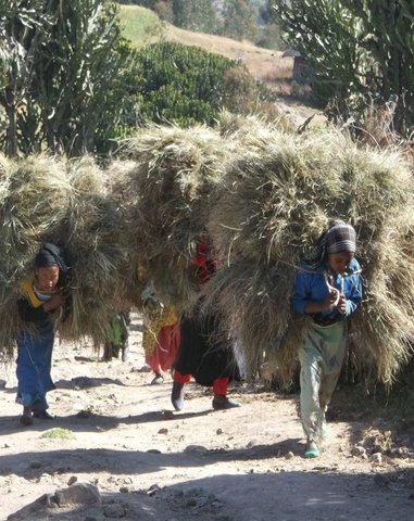
Gully erosion management begins with assessment and mapping of gully erosion that helps to have an overview of erosion, to document extent of damage, to identify the nature and causes of gully formation, and gives relevant information to design appropriate measures. At establishment stage, gully management requires: catchment treatment using different land treatment measures; runoff diversion by cutoff drain; and stabilization of gully sections by physical structures and vegetative measures. Stones for the construction of terraces, cutoff drains and waterways are required. Depending on the nature of gully and available material for construction, either stones, sand bags, brush woods, bamboo mat, gabion or concrete (sand, gravel and cement) are needed for constructing check-dams in a gully section. Different tree/shrub seedlings, grass cuttings, and seedlings of fruit trees are required to reinforce and stabilize the gully sections. The respective labor requirement for stone collection, construction of retaining wall, and gully reshaping is 0.5m3/person day, 5m/person day, and 1m3/person day. Approximately 0.25, 0.50, 0.50, 0.50 , and 1.0 m3/person day is required to construct gabion, loose stone, arc weir, sand bag, and bamboo mat check-dams respectively. About 3.0 m/person day is needed to construct brushwood check dams. The treated gullies should be checked regularly. The maintenance requirement is closely monitored and immediate repair is essential to avoid further damage and eventual collapse of structures. The inputs important for maintenance include stones or other materials for check dams, seedlings to replant areas covered with non-survived seedlings.
Gully erosion is prevalent in areas where excess runoff occurs in high rainfall areas associated with moderate to high erodible soils. It occurs in range of wet highland to moist Kolla areas where annual rainfall exceeds 900mm. Its occurrence is more frequent in heavy clay soils (Vertisols) characterized by low infiltration and in clay soils (like Nitosols) characterized by low organic matter. Often, gully formation occurs on overgrazed pasture lands and inappropriately managed crop lands. Gully erosion control requires mobilization of high input or materials and labor. Larger gullies need to be rehabilitated and treated through community labor mobilization. Subsequent maintenance activities, monitoring and benefit sharing should be made by the user groups who are entitled to utilize the benefits.
The living condition depends on subsistence crop-livestock mixed farming. On average households have 5-6 family size. Crop production is meant for home consumption with small surplus for local market. The services related to water supply, energy supply, and infrastructure are low. Besides it is an asset, animals often used to cope shocks during drought periods.
2.3 รูปภาพของเทคโนโลยี
อัลบั้มสื่อบันทึก
2.5 ประเทศภูมิภาค หรือสถานที่ตั้งที่เทคโนโลยีได้นำไปใช้และได้รับการครอบคลุมโดยการประเมินนี้
ประเทศ:
เอธิโอเปีย
ภูมิภาค/รัฐ/จังหวัด:
Amhara National Regional State (ANRS)
ข้อมูลจำเพาะเพิ่มเติมของสถานที่ตั้ง :
Dembecha/Mecha/Yilmana Densa
2.6 วันที่การดำเนินการ
ถ้าไม่รู้ปีที่แน่นอน ให้ระบุวันที่โดยประมาณ:
- น้อยกว่า 10 ปี (ไม่นานนี้)
2.7 คำแนะนำของเทคโนโลยี
ให้ระบุว่าเทคโนโลยีถูกแนะนำเข้ามาอย่างไร:
- ในช่วงการทดลองหรือการทำวิจัย
- ทางโครงการหรือจากภายนอก
ความคิดเห็น (ประเภทของโครงการ เป็นต้น) :
Since gully erosion management requires combination of practices, many actors mainly research, local development actors, community, and project are involved in the development of the technology
3. การจัดประเภทของเทคโนโลยี SLM
3.1 วัตถุประสงค์หลักของเทคโนโลยี
- ลด ป้องกัน ฟื้นฟู การเสื่อมโทรมของที่ดิน
3.2 ประเภทของการใช้ที่ดินในปัจจุบันที่ได้นำเทคโนโลยีไปใช้

พื้นที่ปลูกพืช
- การปลูกพืชล้มลุกอายุปีเดียว

ทุ่งหญ้าเลี้ยงสัตว์
ทุ่งหญ้าเลี้ยงสัตว์ที่ใช้พื้นที่กว้าง:
- กึ่งเร่ร่อน / อาจมีการทำทุ่งหญ้าเลี้ยงสัตว์ร่วมด้วย (Semi-nomadism/ pastoralism)
ทุ่งหญ้าเลี้ยงสัตว์ที่มีการจัดการแบบเข้มข้นหรือการผลิตอาหารสัตว์:
- ตัดแล้วขนไป / ไม่มีการปล่อยแทะเล็มเอง (Cut-and-carry / zero grazing)
แสดงความคิดเห็น:
Major land use problems (compiler’s opinion): Land degradation due to different forms of soil erosion and nutrient depletion, overgrazing, shortage of pasture lands and its low productivity, excessive and inappropriate construction of traditional ditches, and increased pressure on trees for the purpose of fuel wood and timber.
Major land use problems (land users’ perception): Soil erosion and soil nutrient depletion, shortage of cultivated land, shortage of grazing land and wood for fuel wood
The type of grazing is often free grazing on communal grazing lands/pasture, supplemented with crop residues and zero grazing combined with improved forages
3.3 ข้อมูลเพิ่มเติมเกี่ยวกับการใช้ที่ดิน
การใช้น้ำของที่ดินที่มีการใช้เทคโนโลยีอยู่:
- จากน้ำฝน
จำนวนของฤดูเพาะปลูกต่อปี:
- 1
ระบุ:
Longest growing period in days: 220, Longest growing period from month to month: May to December; Second longest growing period in days: 180, Second longest growing period from month to month: June to November
ความหนาแน่นของปศุสัตว์ (ถ้าเกี่ยวข้อง):
> 100 LU /km2
3.4 กลุ่ม SLM ที่ตรงกับเทคโนโลยีนี้
- การปิดล้อมพื้นที่ (หยุดการใช้ประโยชน์ สนับสนุนการฟื้นฟู)
3.5 กระจายตัวของเทคโนโลยี
ระบุการกระจายตัวของเทคโนโลยี:
- กระจายไปอย่างสม่ำเสมอในพื้นที่
ถ้าหากว่าเทคโนโลยีได้มีการกระจายออกไปอย่างสม่ำเสมอในพื้นที่ ให้ระบุปริมาณพื้นที่ที่ได้รับการครอบคลุมถึง:
- 10-100 ตร.กม.
3.6 มาตรการ SLM ที่ประกอบกันเป็นเทคโนโลยี

มาตรการอนุรักษ์ด้วยวิธีพืช
- V1: ต้นไม้และพุ่มไม้คลุมดิน
- V2: หญ้าและไม้ยืนต้น

มาตรการอนุรักษ์ด้วยโครงสร้าง
- S2: ทำนบ เขื่อนดิน
- S3: Graded ditches, channels, waterways
- S4: คูน้ำแนวระดับ หลุม
- S6: กำแพง สิ่งกีดขวาง รั้วไม้ รั้วต่างๆ
- S11: อื่น ๆ
แสดงความคิดเห็น:
Type of vegetative measures: aligned: -contour, aligned: -along boundary
3.7 รูปแบบหลักของการเสื่อมโทรมของที่ดินที่ได้รับการแก้ไขโดยเทคโนโลยี

การกัดกร่อนของดินโดยน้ำ
- Wg (Gully erosion): การกัดกร่อนแบบร่องธารหรือการทำให้เกิดร่องน้ำเซาะ
- Wo (Offsite degradation): ผลกระทบนอกพื้นที่

การเสื่อมโทรมของดินทางด้านชีวภาพ
- Bc (Reduction of vegetation cover): การลดลงของจำนวนพืชที่ปกคลุมดิน
แสดงความคิดเห็น:
Main causes of degradation: deforestation / removal of natural vegetation (incl. forest fires), over-exploitation of vegetation for domestic use, overgrazing, Heavy / extreme rainfall (intensity/amounts), population pressure
Secondary causes of degradation: soil management, crop management (annual, perennial, tree/shrub), urbanisation and infrastructure development (Urbanization and infrastructure development induced excessive compaction, unprotected drainage systems and lead to gully formation), floods, land tenure (Land under undefined or communal use of grazing lands are subject to mismanagement that result in gully formation), poverty / wealth
3.8 การป้องกัน การลดลง หรือการฟื้นฟูความเสื่อมโทรมของที่ดิน
ระบุเป้าหมายของเทคโนโลยีกับความเสื่อมโทรมของที่ดิน:
- ลดความเสื่อมโทรมของดิน
- ฟื้นฟูบำบัดที่ดินที่เสื่อมโทรมลงอย่างมาก
4. ข้อมูลจำเพาะด้านเทคนิค กิจกรรมการนำไปปฏิบัติใช้ ปัจจัยนำเข้า และค่าใช้จ่าย
4.1 แบบแปลนทางเทคนิคของเทคโนโลยี
ผู้เขียน:
MOA, 2005, Water and Land Resource Center
4.2 ข้อมูลจำเพาะด้านเทคนิคและการอธิบายแบบแปลนทางเทคนิค
A reshaped gully section treated with an integrated gully control measures including check dams made of loose stone and wooden and vegetative tree/shrub and grass hedgerows planted on the sides of gullies.
Location: Debre Mewi Learning Watershed. Yilmana Densa/West Gojam/Amhara Region
Date: 6/27/2016
Technical knowledge required for field staff / advisors: high (It requires knowledge of peak runoff and runoff management and skills to integrate different measures)
Technical knowledge required for land users: high (It needs skills to construct physical measures, and regular monitoring and maintenance of practices. The users must know and understand the growth nature and harvesting stage tree/shrub, grass species)
Main technical functions: control of concentrated runoff: impede / retard, control of concentrated runoff: drain / divert, reduction of slope angle
Secondary technical functions: reduction of slope length, improvement of ground cover, stabilisation of soil (eg by tree roots against land slides), increase of infiltration
Aligned: -contour
Vegetative material: T : trees / shrubs, G : grass
Number of plants per (ha): 2600
Spacing between rows / strips / blocks (m): 2-3
Vertical interval within rows / strips / blocks (m): 0.5-1.0
Width within rows / strips / blocks (m): 0.5
Aligned: -graded strips
Vegetative material: T : trees / shrubs
Aligned: -along boundary
Number of plants per (ha): 200
Vertical interval within rows / strips / blocks (m): 1
Width within rows / strips / blocks (m): 1
In blocks
Vegetative material: T : trees / shrubs
Vegetative measure: Alinged along side wall of gully
Vegetative material: T : trees / shrubs
Number of plants per (ha): 6800
Spacing between rows / strips / blocks (m): 2-3.0
Vertical interval within rows / strips / blocks (m): 0.5-1.0
Width within rows / strips / blocks (m): 0.5
Vegetative measure: Aligned along side wall of gully
Vegetative material: T : trees / shrubs
Number of plants per (ha): 4800
Spacing between rows / strips / blocks (m): 2-3.0
Vertical interval within rows / strips / blocks (m): 0.5
Width within rows / strips / blocks (m): 0.5
Vegetative measure: Vegetative material: T : trees / shrubs
Trees/ shrubs species: Susbania sesban, Acacia decurrence, treelucern, Acacia saligna
Grass species: Elphant grass, Sudan grass
Slope (which determines the spacing indicated above): 20-30%%
If the original slope has changed as a result of the Technology, the slope today is (see figure below): 18-25%%
Gradient along the rows / strips: 0.5%
Diversion ditch/ drainage
Depth of ditches/pits/dams (m): 0.3-0.7
Width of ditches/pits/dams (m): 1.2-2.8
Length of ditches/pits/dams (m): 100-250
Waterway
Depth of ditches/pits/dams (m): 0.3
Width of ditches/pits/dams (m): 1.5-2.0
Structural measure: Check dams
Vertical interval between structures (m): 1
Spacing between structures (m): 10-15
Height of bunds/banks/others (m): 1-1.5
Width of bunds/banks/others (m): 1.5-3.5
Construction material (earth): Excavated soil
Construction material (stone): Loose stones for check dam
Construction material (wood): Brush wood for check dam
Slope (which determines the spacing indicated above): 10-18%
If the original slope has changed as a result of the Technology, the slope today is: 8-12%
Vegetation is used for stabilisation of structures.
4.3 ข้อมูลทั่วไปเกี่ยวกับการคำนวณปัจจัยนำเข้าและค่าใช้จ่าย
อื่นๆ หรือสกุลเงินประจำชาติ (ระบุ):
ETB
ระบุอัตราแลกเปลี่ยนจากดอลลาร์สหรัฐเป็นสกุลเงินท้องถิ่น (ถ้าเกี่ยวข้อง) คือ 1 เหรียญสหรัฐ =:
20.0
ระบุค่าเฉลี่ยของค่าจ้างในการจ้างแรงงานต่อวัน:
2.50
4.4 กิจกรรมเพื่อการจัดตั้ง
| กิจกรรม | ประเภทของมาตรการ | ช่วงเวลาดำเนินการ | |
|---|---|---|---|
| 1. | Seedling preparation | ด้วยวิธีพืช | January-June |
| 2. | Seedling Transportation | ด้วยวิธีพืช | June-July |
| 3. | Grass split transportation | ด้วยวิธีพืช | June -July |
| 4. | Plantation of biological measures inside the gully | ด้วยวิธีพืช | July |
| 5. | Surveying | ด้วยโครงสร้าง | Dry season |
| 6. | Reshaping of gully | ด้วยโครงสร้าง | Dry season |
| 7. | Construction of cutoff drains | ด้วยโครงสร้าง | Dry season |
| 8. | Construction of waterways | ด้วยโครงสร้าง | Dry season |
| 9. | Construction of stone check dams | ด้วยโครงสร้าง | Dry season |
4.5 ค่าใช้จ่ายของปัจจัยนำเข้าที่จำเป็นสำหรับการจัดตั้ง
| ปัจจัยนำเข้า | หน่วย | ปริมาณ | ค่าใช้จ่ายต่อหน่วย | ค่าใช้จ่ายทั้งหมดต่อปัจจัยนำเข้า | %ของค่าใช้จ่ายที่ก่อให้เกิดขึ้นโดยผู้ใช้ที่ดิน | |
|---|---|---|---|---|---|---|
| แรงงาน | labour | ha | 1.0 | 8319.0 | 8319.0 | 99.0 |
| อุปกรณ์ | animal traction | ha | 1.0 | 9.0 | 9.0 | 100.0 |
| อุปกรณ์ | tools | ha | 1.0 | 901.8 | 901.8 | 50.0 |
| วัสดุด้านพืช | grass | ha | 1.0 | 20.0 | 20.0 | |
| วัสดุด้านพืช | seeds | ha | 1.0 | 24.0 | 24.0 | |
| วัสดุด้านพืช | seedlings | ha | 1.0 | 63.45 | 63.45 | |
| ปุ๋ยและสารฆ่า/ยับยั้งการเจริญเติบโตของสิ่งมีชีวิต (ไบโอไซด์) | compost/manure | ha | 1.0 | 15.86 | 15.86 | |
| วัสดุสำหรับก่อสร้าง | stone | ha | 1.0 | 1405.0 | 1405.0 | 91.0 |
| วัสดุสำหรับก่อสร้าง | wood | ha | 1.0 | 27.6 | 27.6 | |
| วัสดุสำหรับก่อสร้าง | earth | ha | 1.0 | 91.2 | 91.2 | |
| ค่าใช้จ่ายทั้งหมดของการจัดตั้งเทคโนโลยี | 10876.91 | |||||
แสดงความคิดเห็น:
Duration of establishment phase: 15 month(s)
4.6 การบำรุงรักษาสภาพหรือกิจกรรมที่เกิดขึ้นเป็นประจำ
| กิจกรรม | ประเภทของมาตรการ | ช่วงระยะเวลา/ความถี่ | |
|---|---|---|---|
| 1. | Seedling preparation | ด้วยวิธีพืช | January-June |
| 2. | Seedling and grass split transportation | ด้วยวิธีพืช | July |
| 3. | Replanting seedlings and grass splits | ด้วยวิธีพืช | July |
| 4. | Maintenance of cutoff drains/waterways | ด้วยโครงสร้าง | Dry season (Jan-Apr) |
| 5. | Maintenance of check dams | ด้วยโครงสร้าง | Dry season (Jan-Apr) |
4.7 ค่าใช้จ่ายของปัจจัยนำเข้าและกิจกรรมที่เกิดขึ้นเป็นประจำที่ต้องการการบำรุงรักษา (ต่อปี)
| ปัจจัยนำเข้า | หน่วย | ปริมาณ | ค่าใช้จ่ายต่อหน่วย | ค่าใช้จ่ายทั้งหมดต่อปัจจัยนำเข้า | %ของค่าใช้จ่ายที่ก่อให้เกิดขึ้นโดยผู้ใช้ที่ดิน | |
|---|---|---|---|---|---|---|
| แรงงาน | labour | ha | 1.0 | 902.0 | 902.0 | 67.0 |
| อุปกรณ์ | animal traction | ha | 1.0 | 4.5 | 4.5 | |
| วัสดุด้านพืช | grass | ha | 1.0 | 10.3 | 10.3 | |
| วัสดุด้านพืช | seedlings | ha | 1.0 | 33.0 | 33.0 | |
| ปุ๋ยและสารฆ่า/ยับยั้งการเจริญเติบโตของสิ่งมีชีวิต (ไบโอไซด์) | compost/manure | ha | 1.0 | 8.5 | 8.5 | |
| วัสดุสำหรับก่อสร้าง | stone | ha | 1.0 | 50.0 | 50.0 | 41.0 |
| วัสดุสำหรับก่อสร้าง | wood | ha | 1.0 | 14.4 | 14.4 | |
| วัสดุสำหรับก่อสร้าง | earth | ha | 1.0 | 45.6 | 45.6 | |
| ค่าใช้จ่ายทั้งหมดของการบำรุงรักษาสภาพเทคโนโลยี | 1068.3 | |||||
แสดงความคิดเห็น:
The costs are calculated on hectare basis
4.8 ปัจจัยสำคัญที่สุดที่มีผลกระทบต่อค่าใช้จ่าย
ปัจจัยสำคัญที่สุดที่มีผลกระทบต่อค่าใช้จ่ายต่างๆ:
The costs for gully erosion management is dependent upon labor, material and transport costs, workability of the soil and maintenance costs.
5. สิ่งแวดล้อมทางธรรมชาติและของมนุษย์
5.1 ภูมิอากาศ
ฝนประจำปี
- < 250 ม.ม.
- 251-500 ม.ม.
- 501-750 ม.ม.
- 751-1,000 ม.ม.
- 1,001-1,500 ม.ม.
- 1,501-2,000 ม.ม.
- 2,001-3,000 ม.ม.
- 3,001-4,000 ม.ม.
- > 4,000 ม.ม.
ข้อมูลจำเพาะ/ความคิดเห็นเรื่องปริมาณน้ำฝน:
Monsoon, 5-6 months rain and 6-7 dry months
เขตภูมิอากาศเกษตร
- กึ่งชุ่มชื้น
Thermal climate class: subtropics. The lowest temperature is above 5°C but below 18°C between November to January
5.2 สภาพภูมิประเทศ
ค่าเฉลี่ยความลาดชัน:
- ราบเรียบ (0-2%)
- ลาดที่ไม่ชัน (3-5%)
- ปานกลาง (6-10%)
- เป็นลูกคลื่น (11-15%)
- เป็นเนิน (16-30%)
- ชัน (31-60%)
- ชันมาก (>60%)
ธรณีสัณฐาน:
- ที่ราบสูง/ที่ราบ
- สันเขา
- ไหล่เขา
- ไหล่เนินเขา
- ตีนเนิน
- หุบเขา
ระดับความสูง:
- 0-100 เมตร
- 101-500 เมตร
- 501-1,000 เมตร
- 1,001-1,500 เมตร
- 1,501-2,000 เมตร
- 2,001-2,500 เมตร
- 2,501-3,000 เมตร
- 3,001-4,000 เมตร
- > 4,000 เมตร
5.3 ดิน
ค่าเฉลี่ยความลึกของดิน:
- ตื้นมาก (0-20 ซ.ม.)
- ตื้น (21-50 ซ.ม.)
- ลึกปานกลาง (51-80 ซ.ม.)
- ลึก (81-120 ซ.ม.)
- ลึกมาก (>120 ซ.ม.)
เนื้อดิน (ดินชั้นบน):
- ปานกลาง (ดินร่วน ทรายแป้ง)
- ละเอียด/หนัก (ดินเหนียว)
อินทรียวัตถุในดิน:
- ปานกลาง (1-3%)
- ต่ำ (<1%)
5.4 ความเป็นประโยชน์และคุณภาพของน้ำ
ระดับน้ำใต้ดิน:
5-50 เมตร
น้ำไหลบ่าที่ผิวดิน:
ปานกลาง
คุณภาพน้ำ (ที่ยังไม่ได้บำบัด):
เป็นน้ำเพื่อการดื่มที่ไม่ดี (จำเป็นต้องได้รับการบำบัด)
5.5 ความหลากหลายทางชีวภาพ
ความหลากหลายทางชนิดพันธุ์:
- ต่ำ
5.6 ลักษณะของผู้ใช้ที่ดินที่นำเทคโนโลยีไปปฏิบัติใช้
แนวทางการตลาดของระบบการผลิต:
- เพื่อการยังชีพ (หาเลี้ยงตนเอง)
รายได้ที่มาจากนอกฟาร์ม:
- < 10% ของรายได้ทั้งหมด
ระดับของความมั่งคั่งโดยเปรียบเทียบ:
- พอมีพอกิน
เป็นรายบุคคล/ครัวเรือน:
- กลุ่ม/ชุมชน
ระดับของการใช้เครื่องจักรกล:
- งานที่ใช้แรงกาย
- การใช้กำลังจากสัตว์
เพศ:
- หญิง
- ชาย
ระบุลักษณะอื่นๆที่เกี่ยวข้องของผู้ใช้ที่ดิน:
Land users applying the Technology are mainly common / average land users
Difference in the involvement of women and men: Women are involved in collecting stones and assisting men on heavy works
Population density: 200-500 persons/km2
Annual population growth: 2% - 3%
80% of the land users are average wealthy.
20% of the land users are poor.
Some land users involve in seasonal labor in towns and sell charcoal
5.7 พื้นที่เฉลี่ยของที่ดินที่เป็นเจ้าของหรือเช่าโดยผู้ใช้ที่ดินที่นำเทคโนโลยีไปปฏิบัติใช้
- < 0.5 เฮกตาร์
- 0.5-1 เฮกตาร์
- 1-2 เฮกตาร์
- 2-5 เฮกตาร์
- 5-15 เฮกตาร์
- 15-50 เฮกตาร์
- 50-100 เฮกตาร์
- 100-500 เฮกตาร์
- 500-1,000 เฮกตาร์
- 1,000-10,000 เฮกตาร์
- >10,000 เฮกตาร์
พิจารณาว่าเป็นขนาดเล็ก กลาง หรือขนาดใหญ่ (ซึ่งอ้างอิงถึงบริบทระดับท้องถิ่น):
- ขนาดเล็ก
5.8 กรรมสิทธิ์ในที่ดิน สิทธิในการใช้ที่ดินและสิทธิในการใช้น้ำ
กรรมสิทธิ์ในที่ดิน:
- รัฐ
สิทธิในการใช้น้ำ:
- เข้าถึงได้แบบเปิด (ไม่ได้จัดระเบียบ)
- เกี่ยวกับชุมชน (ถูกจัดระเบียบ)
แสดงความคิดเห็น:
Land use rights on crop land is individual while on grazing lands it is communal either unorganized or organized in some cases. Water is open accessible in most cases except organized communal utilization for some developed drinking water sources.
5.9 การเข้าถึงบริการและโครงสร้างพื้นฐาน
สุขภาพ:
- จน
- ปานกลาง
- ดี
การศึกษา:
- จน
- ปานกลาง
- ดี
ความช่วยเหลือทางด้านเทคนิค:
- จน
- ปานกลาง
- ดี
การจ้างงาน (เช่น ภายนอกฟาร์ม):
- จน
- ปานกลาง
- ดี
ตลาด:
- จน
- ปานกลาง
- ดี
พลังงาน:
- จน
- ปานกลาง
- ดี
ถนนและการขนส่ง:
- จน
- ปานกลาง
- ดี
น้ำดื่มและการสุขาภิบาล:
- จน
- ปานกลาง
- ดี
บริการด้านการเงิน:
- จน
- ปานกลาง
- ดี
6. ผลกระทบและสรุปคำบอกกล่าว
6.1 ผลกระทบในพื้นที่ดำเนินการ (On-site) จากการใช้เทคโนโลยี
ผลกระทบทางด้านเศรษฐกิจและสังคม
การผลิต
การผลิตพืชที่ใช้เลี้ยงปศุสัตว์
แสดงความคิดเห็น/ระบุ:
Gullies are treated for purpose of improved grass and legume fodder production like napier, susbania, local grasses
ความหลากหลายของผลิตภัณฑ์
แสดงความคิดเห็น/ระบุ:
Honey, fruits can be diversified under intensive gully development
รายได้และค่าใช้จ่าย
ความหลากหลายของแหล่งผลิตรายได้
แสดงความคิดเห็น/ระบุ:
High fodder biomass provide an opportunity to do fattening; sometimes used to grow fruits;
ภาระงาน
แสดงความคิดเห็น/ระบุ:
Under low productive soil where recovery rate is slow, establishment and maintenance cost of labor is high
ผลกระทบด้านสังคมวัฒนธรรมอื่น ๆ
สถาบันของชุมชน
แสดงความคิดเห็น/ระบุ:
Watershed committee and user groups are established
SLM หรือความรู้เรื่องความเสื่อมโทรมของที่ดิน
แสดงความคิดเห็น/ระบุ:
Awareness of the community on gully management increased
การบรรเทาความขัดแย้ง
แสดงความคิดเห็น/ระบุ:
Gullies are stabilized and no more conflict
contribution to human well-being
แสดงความคิดเห็น/ระบุ:
Land users are organized into user groups and harvest the biomass (grass and fodder) for livestock feed which result in increased livestock productivity. Some land users attempt to fatten cattle and gain benefit.
ผลกระทบด้านนิเวศวิทยา
วัฐจักรน้ำหรือน้ำบ่า
น้ำไหลบ่าที่ผิวดิน
แสดงความคิดเห็น/ระบุ:
Significant reduction of damage due to runoff
การระบายน้ำส่วนเกิน
แสดงความคิดเห็น/ระบุ:
Cutoff drains used to drain excess runoff upstream
น้ำบาดาลหรือระดับน้ำในแอ่งน้ำบาดาล
ดิน
สิ่งปกคลุมดิน
แสดงความคิดเห็น/ระบุ:
Plantation of gullies increase cover and biomass production
การสูญเสียดิน
แสดงความคิดเห็น/ระบุ:
Check dams significantly reduce the soil loss from gullies
ความหลากหลายทางชีวภาพของพืชและสัตว์
มวลชีวภาพ/เหนือดินชั้น C
6.2 ผลกระทบนอกพื้นที่ดำเนินการ (Off-site) จากการใช้เทคโนโลยี
การไหลของน้ำคงที่และสม่ำเสมอในช่วงฤดูแล้ง
แสดงความคิดเห็น/ระบุ:
Stream size and duration has improved
การทับถมของดินตะกอนพื้นที่ท้ายน้ำ
ความเสียหายต่อโครงสร้างพื้นฐานของรัฐหรือของเอกชน
แสดงความคิดเห็น/ระบุ:
Reduction of damage on houses
6.3 การเผชิญและความตอบสนองของเทคโนโลยีต่อการเปลี่ยนแปลงสภาพภูมิอากาศที่ค่อยเป็นค่อยไป และสภาพรุนแรงของภูมิอากาศ / ภัยพิบัติ (ที่รับรู้ได้โดยผู้ใช้ที่ดิน)
สภาพรุนแรงของภูมิอากาศ (ภัยพิบัติ)
ภัยพิบัติทางอุตุนิยมวิทยา
| เทคโนโลยีมีวิธีการรับมืออย่างไร | |
|---|---|
| พายุฝนประจำท้องถิ่น | ไม่ค่อยดี |
ภัยพิบัติจากสภาพภูมิอากาศ
| เทคโนโลยีมีวิธีการรับมืออย่างไร | |
|---|---|
| ภัยจากฝนแล้ง | ดี |
ภัยพิบัติจากน้ำ
| เทคโนโลยีมีวิธีการรับมืออย่างไร | |
|---|---|
| น้ำท่วมตามปกติ (แม่น้ำ) | ไม่ค่อยดี |
แสดงความคิดเห็น:
Gully erosion management involves combination of biological and physical measures. Strong structural measures and upstream runoff management practices should be applied to tolerate flooding.
6.4 การวิเคราะห์ค่าใช้จ่ายและผลประโยชน์ที่ได้รับ
ผลประโยชน์ที่ได้รับเปรียบเทียบกับค่าใช้จ่ายในการจัดตั้งเป็นอย่างไร (จากมุมมองของผู้ใช้ที่ดิน)
ผลตอบแทนระยะสั้น:
ด้านบวกเล็กน้อย
ผลตอบแทนระยะยาว:
ด้านบวก
ผลประโยชน์ที่ได้รับเปรียบเทียบกับค่าใช้จ่ายในการบำรุงรักษาหรือต้นทุนที่เกิดขึ้นซ้ำอีก เป็นอย่างไร (จากมุมมองของผู้ใช้ที่ดิน)
ผลตอบแทนระยะสั้น:
ด้านบวก
ผลตอบแทนระยะยาว:
ด้านบวกอย่างมาก
แสดงความคิดเห็น:
The short term economic benefits of management of gully erosion include grass and fodder production for livestock feed. While the long term benefits may include product diversification like fruit, fodder, and grass production.
6.5 การปรับตัวของเทคโนโลยี
แสดงความคิดเห็น:
About 3-5% of the total area of watersheds are treated with gully management. Gullies formed on crop lands and communal grazing lands are management collectively by the community labor with external material support such as gabion and seedlings
Gully management is beyond the capacity of land users. So, they are often supported with seedlings and gabions for large gullies
There is a little trend towards spontaneous adoption of the Technology
Land users show interest and motivation by delineating gully damage areas and control free grazing. They also do fencing with external support for nails and seedlings.
6.7 จุดแข็ง / ข้อได้เปรียบ / โอกาสของเทคโนโลยี
| จุดแข็ง / ข้อได้เปรียบ / โอกาสในทัศนคติของผู้ใช้ที่ดิน |
|---|
| It increases fodder production |
| It protects further expansion and damage of settlement areas and infrastructures |
| It increases the flow of streams |
| จุดแข็ง / ข้อได้เปรียบ / โอกาสในทัศนคติของผู้รวบรวมหรือวิทยากรหลัก |
|---|
| Gully erosion management provides an immediate fodder for cut-and-carry grazing system and encourages zero grazing |
| It controls erosion and sediment transport as well it increases stream flows to downstream and subsequently changed to productive area |
| It reduces conflict among adjacent land holders due to formation of gullies |
| It does not only reduce degradation but also stabilize the soil, water and vegetation system in the area |
| It increases the awareness level of farmers about land degradation and its causes |
6.8 จุดอ่อน / ข้อเสียเปรียบ / ความเสี่ยงของเทคโนโลยีและวิธีการแก้ไข
| จุดอ่อน / ข้อเสียเปรียบ / ความเสี่ยงในทัศนคติของผู้ใช้ที่ดิน | มีวิธีการแก้ไขได้อย่างไร |
|---|---|
| It is labor intensive and sometimes harbor rodents and pests | Apply traditional collective action mechanisms |
| จุดอ่อน / ข้อเสียเปรียบ / ความเสี่ยงในทัศนคติของผู้รวบรวมหรือวิทยากรหลัก | มีวิธีการแก้ไขได้อย่างไร |
|---|---|
| It requires high labor for regular monitoring and maintenance of structures and protect from damage by excessive runoff | Establish by laws and procedures for collective actions among the user groups |
7. การอ้างอิงและการเชื่อมต่อ
7.1 วิธีการและแหล่งข้อมูล
- ไปเยี่ยมชมภาคสนาม การสำรวจพื้นที่ภาคสนาม
- การสัมภาษณ์กับผู้ใช้ที่ดิน
7.2 การอ้างอิงถึงสิ่งตีพิมพ์
หัวข้อ, ผู้เขียน, ปี, หมายเลข ISBN:
Gully Rehabilitation: What Does it Costs to Heal Gullies and Make Productive? WLRC Brief No. 3. June 2015
ชื่อเรื่อง ผู้เขียน ปี ISBN:
www.wlrc-eth.org
ลิงก์และโมดูล
ขยายทั้งหมด ย่อทั้งหมดลิงก์
Community Organizations and Mobilization for Soil and Water … [เอธิโอเปีย]
Community mobilization for soil and water conservation work in a watershed planning unit is an approach for collective action by organizing all active labor forces living in the kebele/peasant association into development group of 20-30 members and further divide into 1:5 work force to implement construction of soil and water …
- ผู้รวบรวม: Gizaw Desta Gessesse
'Cut and Carry' Grazing system or 'Zero Grazing' … [เอธิโอเปีย]
Cut and carry grazing system (alternatively called zero grazing) is an approach where the community is consulted to identify and agree on areas to be closed and protected from free grazing; establish user groups are established to share the fodder biomass harvested from communal closed areas equitably; they utilize tree/shrub …
- ผู้รวบรวม: Gizaw Desta Gessesse
โมดูล
ไม่มีโมดูล