Community supported pasture and rangeland rehabilitation works [แองโกลา]
- ผู้สร้างสรรค์:
- การอัพเดท:
- ผู้รวบรวม: Nicholas Euan Sharpe
- ผู้เรียบเรียง: Txaran Basterrechea
- ผู้ตรวจสอบ: Rima Mekdaschi Studer
technologies_3141 - แองโกลา
- บทสรุปทั้งหมดในรูปแบบของ PDF
- บทสรุปทั้งหมดในรูปแบบของ PDF เพื่อพิมพ์
- บทสรุปทั้งหมดในรูปหน้าเว็บ
- บทสรุปทั้งหมด (ไม่มีการจัดเรียง)
- Community supported pasture and rangeland rehabilitation works: 31 มกราคม 2018 (inactive)
- Community supported pasture and rangeland rehabilitation works: 16 กุมภาพันธ์ 2018 (inactive)
- Community supported pasture and rangeland rehabilitation works: 6 มีนาคม 2019 (inactive)
- Community supported pasture and rangeland rehabilitation works: 2 พฤศจิกายน 2021 (public)
ดูส่วนย่อย
ขยายทั้งหมด ย่อทั้งหมด1. ข้อมูลทั่วไป
1.2 รายละเอียดที่ติดต่อได้ของผู้รวบรวมและองค์กรที่เกี่ยวข้องในการประเมินและการจัดเตรียมทำเอกสารของเทคโนโลยี
ผู้เชี่ยวชาญ SLM:
ชื่อของโครงการซึ่งอำนวยความสะดวกในการทำเอกสารหรือการประเมินเทคโนโลยี (ถ้าเกี่ยวข้อง)
Reabilitação de terras e gestão das áreas de pastagem nos sistemas de produção agro-pastoris dos pequenos produtores no sudoeste de Angola (RETESA)ชื่อขององค์กรซึ่งอำนวยความสะดวกในการทำเอกสารหรือการประเมินเทคโนโลยี (ถ้าเกี่ยวข้อง)
FAO Angola (FAO Angola) - แองโกลา1.3 เงื่อนไขการใช้ข้อมูลที่ได้บันทึกผ่านทาง WOCAT
วันที่เก็บรวบรวมข้อมูล(ภาคสนาม) :
15/05/2017
ผู้รวบรวมและวิทยากรหลักยอมรับเงื่อนไขเกี่ยวกับการใช้ข้อมูลที่ถูกบันทึกผ่านทาง WOCAT:
ใช่
1.4 การเปิดเผยเรื่องความยั่งยืนของเทคโนโลยีที่ได้อธิบายไว้
เทคโนโลยีที่ได้อธิบายไว้นี้เป็นปัญหาของความเสื่อมโทรมโทรมของที่ดินหรือไม่ จึงไม่ได้รับการยอมรับว่าเป็นเทคโนโลยีเพื่อการจัดการที่ดินอย่างยั่งยืน:
ไม่ใช่
2. การอธิบายลักษณะของเทคโนโลยี SLM
2.1 การอธิบายแบบสั้น ๆ ของเทคโนโลยี
คำจำกัดความของเทคโนโลยี:
The technology was developed and used to select key pasture and fodder species and reintroduce them into strategic areas through stakeholder participation. The technology was also supported by communal management plans were created to address root causes of land degradation.
2.2 การอธิบายแบบละเอียดของเทคโนโลยี
คำอธิบาย:
The technology was developed and implemented through the RETESA Project “Land rehabilitation and rangelands management in smallholders agro-pastoral production systems in south western Angola”, which is a project owned and implemented by the Ministry of Environment of the Government of Angola with technical and methodological assistance from The Food and Agriculture Organization of the United Nations (FAO) and financed by the Global Environmental Found (GEF).
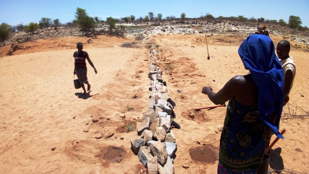
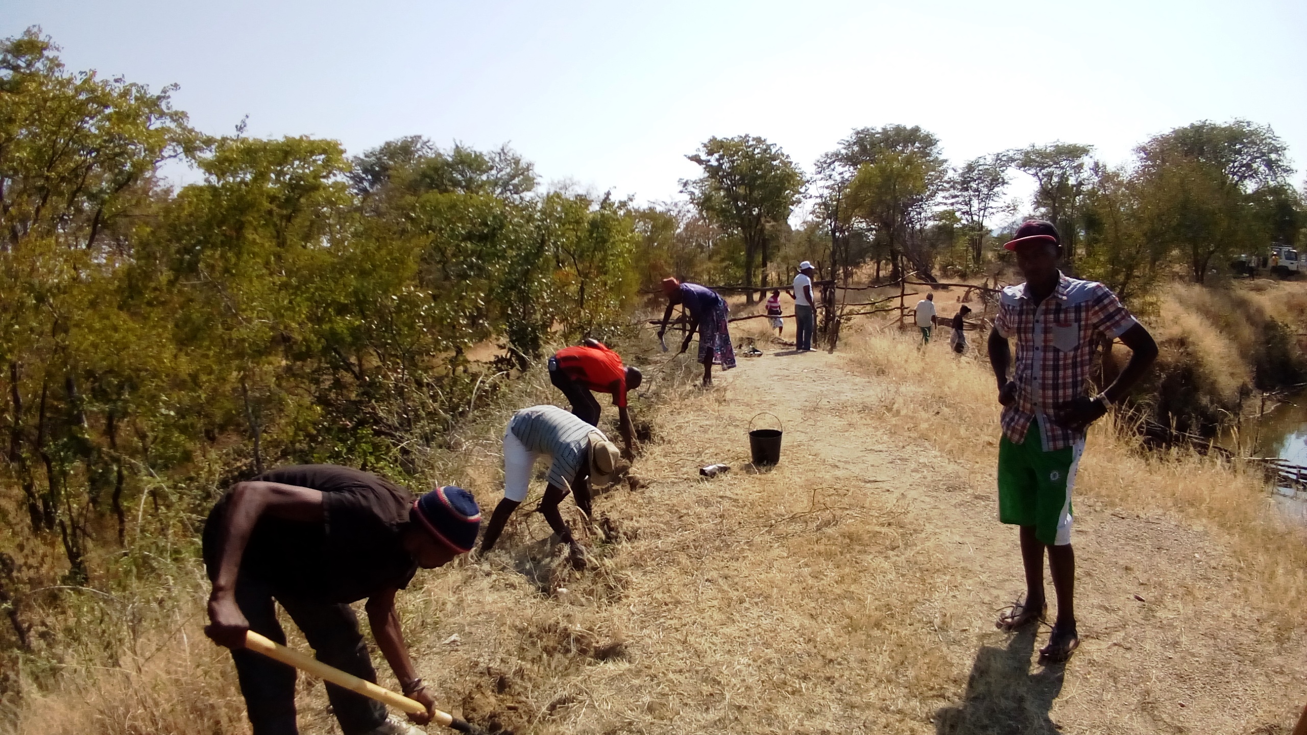
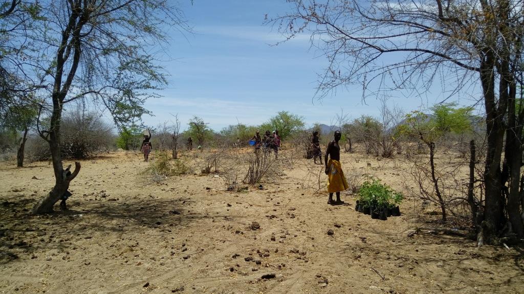
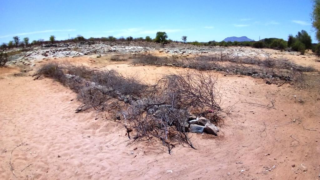
Improper grazing regimes and animal management on part of pastoral communities in SW Angola have led to degradation of rangeland and pastoral resources, with perennial grassland species and shrubs having been effectively eliminated from lowland grazing areas. The pastoral communities of the area know their environment extremely well and are aware of the land degradation happening around them. They identified crucial areas for the rehabilitation works, selecting mostly areas around water points that were used both by local and transhumant herders. Through these works, the locals sought to increase ground cover to reduce sediment loads entering waterways (erosion control), provide shade for livestock, increase forage production and introduce legumes and multiuse forage trees in areas of high animal traffic. A total of 4 areas in the Bibala and Virei Municipalities were identified for the activities.
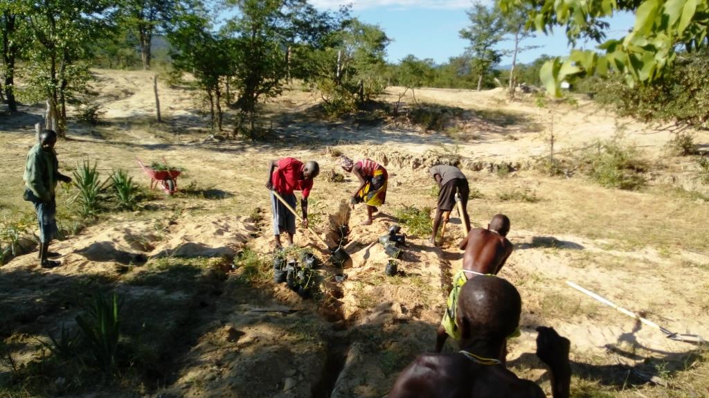
The communities were heavily involved in the selection and propagation of plant species for the rehabilitation works. The project field staff also ran participatory, field palatability trials with them to confirm the plants selected met their expectations and to enhance their understanding of livestock nutrition and how it related to animal health. Once the species were chosen, seed was collected by the communities and the Project Technicians and was multiplied in 32 Agro-Pastoral Field School Nurseries and 2 Government funded Veterinary Research Stations. A total of 15 species were identified, with Eragrostis superba, Urochloa mosambicensis, Acacia nilotica, Faidherbia albida, Leucaena leucocephala and Moringa oleifera being the most valued by the communities as forage and multiuse species. Trees and shrubs were germinated from seed with success. As their seeds failed to germinate by standard methods, native grass species were multiplied by root divisions of plants collected in cultivated fields so as not to remove any from natural areas. Early field trials ruled out direct seeding methods.
As the majority of areas selected for the rehabilitation works were focused around water points and waterways, the soils were generally alluvial, sandy loams. Precipitation is highest in the areas to the north, ranging from 600mm in the upper areas of the Bibala Municipality to 200mm in the areas to the south in Virei. In general, the vegetation communities could be described as dry sclerophyll woodlands with Colophospermum mopane being the dominant tree species, with forest cover decreasing in height and density as one moves south toward drier areas.
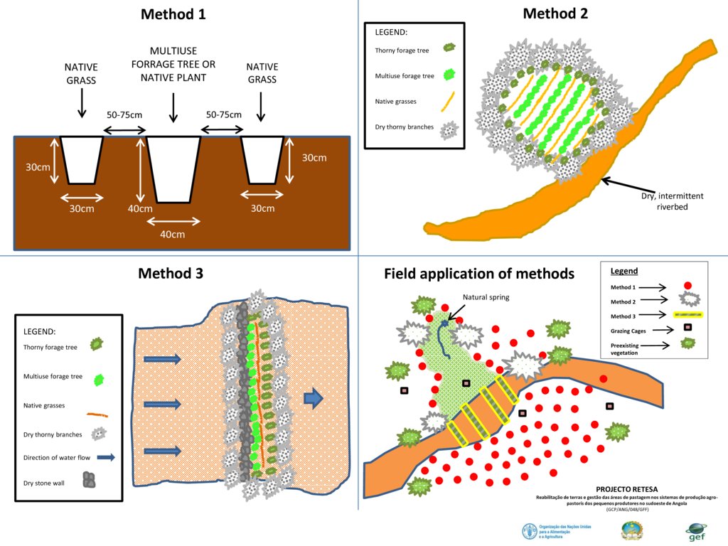
Through close collaboration with the participant communities, 3 rehabilitation methods were designed and improved upon throughout the Project's duration. Method 1 was used to plant open areas within the rehabilitation zone, Method 2 was used to introduce and protect concentrated plantings of the selected species in strategic locations within the landscape and Method 3 was used to recuperate riparian vegetation and reduce sediment loads in waterways. The 3 Methods used are described in more detail in the Technical Drawing on page 3. To increase appropriation and increase the effectiveness of the rehabilitation works, land management plans and other supporting activities were also carried out.
2.3 รูปภาพของเทคโนโลยี
อัลบั้มสื่อบันทึก
2.5 ประเทศภูมิภาค หรือสถานที่ตั้งที่เทคโนโลยีได้นำไปใช้และได้รับการครอบคลุมโดยการประเมินนี้
ประเทศ:
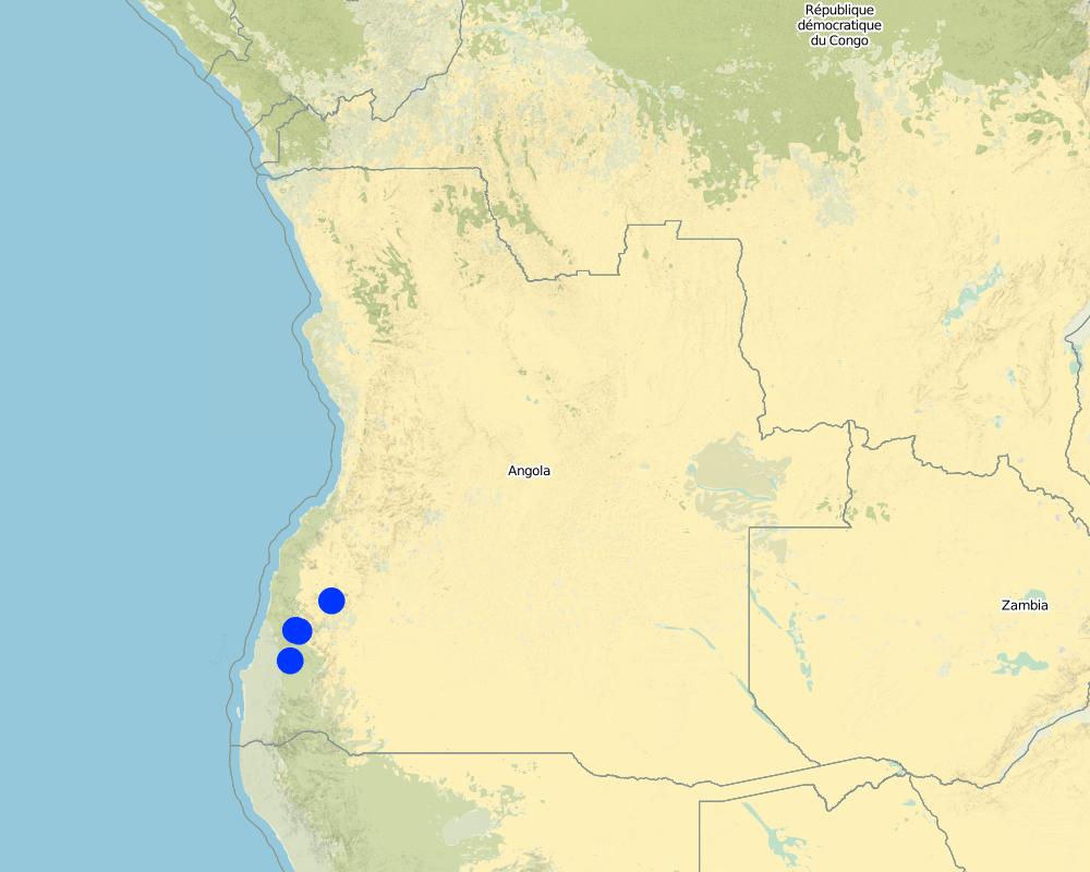
แองโกลา
ภูมิภาค/รัฐ/จังหวัด:
Province of Namibe
ข้อมูลจำเพาะเพิ่มเติมของสถานที่ตั้ง :
Municipalities of Bibala and Virei
แสดงความคิดเห็น:
There are 3 main rehabilitation areas, all within the Namibe Province in Southern Angola.
Map
×2.6 วันที่การดำเนินการ
ถ้าไม่รู้ปีที่แน่นอน ให้ระบุวันที่โดยประมาณ:
- น้อยกว่า 10 ปี (ไม่นานนี้)
2.7 คำแนะนำของเทคโนโลยี
ให้ระบุว่าเทคโนโลยีถูกแนะนำเข้ามาอย่างไร:
- ทางโครงการหรือจากภายนอก
ความคิดเห็น (ประเภทของโครงการ เป็นต้น) :
The proposed project: “Land rehabilitation and rangelands management in smallholders’ agropastoral production systems in southwestern Angola” (RETESA) is a joint effort by the Ministério do Ambiente (MA), Ministério da Agricultura e do Desenvolvimento Rural e das Pescas (MINANDER), Governo Provincial do Namibe, Governo Provincial do Huila, and Governo Provincial de Benguela, together with FAO and GEF. In line with the GEF-5 Land Degradation strategy, the project’s goal is to create an enhanced enabling environment in the agricultural sector and a sustained flow of agro-ecosystem services.
3. การจัดประเภทของเทคโนโลยี SLM
3.1 วัตถุประสงค์หลักของเทคโนโลยี
- ปรับปรุงการผลิตให้ดีขึ้น
- ลด ป้องกัน ฟื้นฟู การเสื่อมโทรมของที่ดิน
- อนุรักษ์ระบบนิเวศน์
- รักษาสภาพหรือปรับปรุงความหลากหลายทางชีวภาพ
- ลดความเสี่ยงของภัยพิบัติ
- ปรับตัวเข้ากับการเปลี่ยนแปลงภูมิอากาศของโลก สภาพภูมิอากาศที่รุนแรงและผลกระทบ
- ชะลอการเปลี่ยนแปลงภูมิอากาศของโลกและผลกระทบ
- สร้างผลกระทบทางด้านเศรษฐกิจที่เป็นประโยชน์
3.2 ประเภทของการใช้ที่ดินในปัจจุบันที่ได้นำเทคโนโลยีไปใช้

ทุ่งหญ้าเลี้ยงสัตว์
ทุ่งหญ้าเลี้ยงสัตว์ที่ใช้พื้นที่กว้าง:
- กึ่งเร่ร่อน / อาจมีการทำทุ่งหญ้าเลี้ยงสัตว์ร่วมด้วย (Semi-nomadism/ pastoralism)
- Transhumance movements
ชนิดพันธุ์สัตว์และผลิตภัณฑ์หลัก:
Cattle and goats.
Milk and meat.

ทางน้ำ แหล่งน้ำ พื้นที่ชุ่มน้ำ
- ทางระบายน้ำ ทางน้ำ
- บ่อน้ำ เขื่อน
- Natural springs
ถ้าการใช้ที่ดินมีการเปลี่ยนแปลงเนื่องมาจากการนำเทคโนโลยีไปปฏิบัติใช้ ให้ระบุการใช้ที่ดินก่อนนำเทคโนโลยีไปปฏิบัติใช้:
Cropping land is increasing in the area as population rates increase and locals move towards more sedimentary livelihoods.
3.3 ข้อมูลเพิ่มเติมเกี่ยวกับการใช้ที่ดิน
การใช้น้ำของที่ดินที่มีการใช้เทคโนโลยีอยู่:
- จากน้ำฝน
จำนวนของฤดูเพาะปลูกต่อปี:
- 1
ความหนาแน่นของปศุสัตว์ (ถ้าเกี่ยวข้อง):
Official data is not available and true livestock numbers are unknown.
3.4 กลุ่ม SLM ที่ตรงกับเทคโนโลยีนี้
- การจัดการปศุสัตว์และทุ่งหญ้าเลี้ยงสัตว์
- การปรับปรุงดิน / พืชคลุมดิน
3.5 กระจายตัวของเทคโนโลยี
ระบุการกระจายตัวของเทคโนโลยี:
- ใช้ ณ จุดที่เฉพาะเจาะจงหรือเน้นไปยังบริเวณพื้นที่ขนาดเล็ก
แสดงความคิดเห็น:
Plantings areas are selected due to their importance and relevance to the local communities. For the most part, the plantings have been centred around key water points. In order to increase impact and scale up the process of rangeland rehabilitation and improvement, management plans are negotiated and agreed upon by the communities through the Green Negotiated Territorial Development Approach (GreeNTD) processes.
3.6 มาตรการ SLM ที่ประกอบกันเป็นเทคโนโลยี

มาตรการอนุรักษ์ด้วยวิธีพืช
- V1: ต้นไม้และพุ่มไม้คลุมดิน
- V2: หญ้าและไม้ยืนต้น

มาตรการอนุรักษ์ด้วยการจัดการ
- M2: การเปลี่ยนแปลงของการจัดการหรือระดับความเข้มข้น
แสดงความคิดเห็น:
The management plans created at the community and administrative level identify a number of large areas which are to serve as 'Grazing Reverses' for the dry season. Therefore, the agreements call for all livestock to abandon the area at the onset of the first rains and not return until the Pastoral Management Forum agrees to open the area for grazing. Once open, the range is available to all pastoralists, those that live in the immediate area and those moving through on their transhumance migration.
3.7 รูปแบบหลักของการเสื่อมโทรมของที่ดินที่ได้รับการแก้ไขโดยเทคโนโลยี

การกัดกร่อนของดินโดยน้ำ
- Wt (Loss of topsoil): การสูญเสียดินชั้นบนหรือการกัดกร่อนที่ผิวดิน
- Wr (Riverbank erosion): การกัดกร่อนริมฝั่งแม่น้ำ

การเสื่อมโทรมของดินทางด้านชีวภาพ
- Bc (Reduction of vegetation cover): การลดลงของจำนวนพืชที่ปกคลุมดิน
- Bh (Loss of habitat): การสูญเสียแหล่งที่อยู่
- Bq (Quantity/biomass decline): การลดลงของปริมาณหรือมวลชีวภาพ
- Bs (Quality and species composition): องค์ประกอบหรือความหลากหลายทางคุณภาพและชนิดพันธุ์ลดลง
- Bl (Loss of soil life): การสูญเสียสิ่งมีชีวิตในดิน
3.8 การป้องกัน การลดลง หรือการฟื้นฟูความเสื่อมโทรมของที่ดิน
ระบุเป้าหมายของเทคโนโลยีกับความเสื่อมโทรมของที่ดิน:
- ลดความเสื่อมโทรมของดิน
- ฟื้นฟูบำบัดที่ดินที่เสื่อมโทรมลงอย่างมาก
4. ข้อมูลจำเพาะด้านเทคนิค กิจกรรมการนำไปปฏิบัติใช้ ปัจจัยนำเข้า และค่าใช้จ่าย
4.1 แบบแปลนทางเทคนิคของเทคโนโลยี
ผู้เขียน:
Projecto RETESA
วันที่:
10/01/2018
4.2 ข้อมูลจำเพาะด้านเทคนิคและการอธิบายแบบแปลนทางเทคนิค
Plantings are typically based on 3 established methods, as seen in the exemples provided.
- Method 1 relies on placing a leguminous, multiuse tree species in the ground with two native grass species to each side of the tree. The holes are dug and a small amount of manure is placed in the bottom of the hole, adding some water to the hole if it is readily available. Then the trees and grasses are planted and well watered. Finally, a branch or two of thorny shrubs or trees are placed over the plants to protect them from grazing (where possible, attempts are made to use thorny branches that were already dead or had fallen).
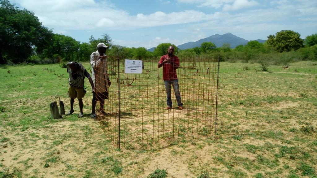
- Method 2 requires the creation of an enclosed, protected area which is then planted in high densities, preferably in low-lying areas where soil moisture is available to support such high concentrations of plants. Dry, dead branches from thorny trees and shrubs were used to create the enclosures and provide protection to these plantings.
- Method 3 is based on the creation of a 'Leaky weir', which is a small stone barrier planted with a mixture of native riparian species placed horizontally to the flow of water. It is intended to slow the flow of water and allow for the recovery of riparian vegetation. The plants are also protected with dry, dead branches from thorny trees and shrubs in this method.
To increase their effectiveness, it is recommended that the 3 methods be combined within the landscape, as seen in the 4th slide 'Field application of methods'.
4.3 ข้อมูลทั่วไปเกี่ยวกับการคำนวณปัจจัยนำเข้าและค่าใช้จ่าย
ให้ระบุว่าค่าใช้จ่ายและปัจจัยนำเข้าได้รับการคำนวณอย่างไร:
- ต่อหน่วยเทคโนโลยี
โปรดระบุหน่วย:
3345 seedlings produced, delivered and planted
ระบุปริมาตร ความยาว เป็นต้น (ถ้าเกี่ยวข้อง):
3345 units
ระบุสกุลเงินที่ใช้คำนวณค่าใช้จ่าย:
- ดอลลาร์สหรัฐ
ระบุค่าเฉลี่ยของค่าจ้างในการจ้างแรงงานต่อวัน:
6 Dollars
4.4 กิจกรรมเพื่อการจัดตั้ง
| กิจกรรม | ประเภทของมาตรการ | ช่วงเวลาดำเนินการ | |
|---|---|---|---|
| 1. | Meetings and field visits with participant communities to identify plant species and their uses | มาตรการอื่น ๆ | Best during growing season |
| 2. | Further meetings to decide on which species are to be multiplied and arrange seed collection | มาตรการอื่น ๆ | Near end of growing season |
| 3. | Seed collection and transportation | มาตรการอื่น ๆ | When seed is available (varies with species) |
| 4. | Instalation of irrigation systems | ด้วยโครงสร้าง | Most communiites need a water extraction and distribution system to create nurseries |
| 5. | Delivery of nursery supplies and instalation of shade cloth | ด้วยโครงสร้าง | Nurseries should have water access and shade |
| 6. | Planting of seeds and care for seedlings at nursery | ด้วยวิธีพืช | Formed part of Agro-Pastoral Farmer Field School activities |
| 7. | Identification of planting areas and timing | มาตรการอื่น ๆ | Should be at beginning of rainy season, or when soil moisture permits |
| 8. | Organisation of materials and tools | มาตรการอื่น ๆ | At least 1 week before the planting |
| 9. | Planting day (preparation of planting holes and transplanting of seedlings) | ด้วยวิธีพืช | 2 days maximum was seen to be optimal |
| 10. | Watering until the plants are established | จัดการพืช | Usually a maximum of 3 watering over 1 week after the plantings |
| 11. | Follow up visits to make sure management agreements are being respected and plants are not being eaten by stock until they are ready | ด้วยการจัดการ | Plants should not be grazed for at least 6 months from planting time until they are well established |
แสดงความคิดเห็น:
The activities and costs given were those needed to produce and plant 3,345 trees and grasses in the 4 rehabilitation areas. Given that 3.345 plants were produced at a cost of $3284.75, the cost per plant produced and planted in the field is $0.98. As the inputs and materials for the 3 methods came from the same source and the methods were implemented together at the same time, no distinction of the costs for each method is avaliable, though the labour and materials are similar enough so that they one could assign the same costs for the 3.
As per the question of planting densities, they are often dependent on numerous factores but one can easily calculate the costs per hectare by knowing plant densities and deducing the costs.
4.5 ค่าใช้จ่ายของปัจจัยนำเข้าที่จำเป็นสำหรับการจัดตั้ง
| ปัจจัยนำเข้า | หน่วย | ปริมาณ | ค่าใช้จ่ายต่อหน่วย | ค่าใช้จ่ายทั้งหมดต่อปัจจัยนำเข้า | %ของค่าใช้จ่ายที่ก่อให้เกิดขึ้นโดยผู้ใช้ที่ดิน | |
|---|---|---|---|---|---|---|
| แรงงาน | Project Technicians/Drivers/Consultants, etc | Person-days | 30.0 | 20.0 | 600.0 | |
| แรงงาน | Plant identification activities and seed collection | Person-days | 10.0 | 6.0 | 60.0 | 100.0 |
| แรงงาน | Plant nursery creation and plant production | Person-days | 16.0 | 6.0 | 96.0 | 100.0 |
| แรงงาน | Participation during planting days | Person-days | 25.0 | 10.0 | 250.0 | 90.0 |
| อุปกรณ์ | Vehicle | Trips | 10.0 | 40.0 | 400.0 | |
| อุปกรณ์ | Nursery supplies (including water system which also supplies water to Farmer Field School) | Materials | 1.0 | 800.0 | 800.0 | 10.0 |
| อุปกรณ์ | Planting supplies (shovels, hoes, wheelbarrows, etc.) | Materials | 1.0 | 120.0 | 120.0 | |
| อุปกรณ์ | Other improvements to water point (fencing, cement blocks, cement, hoses, etc.) | Materials | 1.0 | 250.0 | 250.0 | |
| อุปกรณ์ | Maps (traced onto paper from projected images for management purposes) | Materials | 1.0 | 10.0 | 10.0 | |
| อุปกรณ์ | Food and Refreshments | Per person | 25.0 | 2.5 | 62.5 | |
| ปุ๋ยและสารฆ่า/ยับยั้งการเจริญเติบโตของสิ่งมีชีวิต (ไบโอไซด์) | Manure (50 grams per sack, 12.500 sacks) | Kilos | 625.0 | 0.25 | 156.25 | 100.0 |
| วัสดุสำหรับก่อสร้าง | Shade-cloth | m2 | 320.0 | 1.5 | 480.0 | |
| ค่าใช้จ่ายทั้งหมดของการจัดตั้งเทคโนโลยี | 3284.75 | |||||
ถ้าผู้ใช้ที่ดินรับภาระน้อยกว่า 100% ของค่าใช้จ่าย ให้ระบุว่าใครเป็นผู้รับผิดชอบส่วนที่เหลือ:
Remaining costs were provided by the RETESA Project.
แสดงความคิดเห็น:
Production depends on the ability of the pastoral communities to produce viable plants. If they are unable to do so, then plants can be bought from Government funded nurseries, though costs per plant will most rise though it can substitute the need for having to purchase a water supply system. The total shown here reflects a percentage (16%) of the costs of installing a water system that supplied water to the whole of the Agro-Pastoral Farmer Field School. These systems usually included a 10,000 litre water tank, a gasoline water pump, extraction pipe and parts, 100 to 200 mts of 1.5" hoses and parts and 3 kms of drip irrigation hose.
4.6 การบำรุงรักษาสภาพหรือกิจกรรมที่เกิดขึ้นเป็นประจำ
| กิจกรรม | ประเภทของมาตรการ | ช่วงระยะเวลา/ความถี่ | |
|---|---|---|---|
| 1. | Meetings to ensure management agreements are being respected. | ด้วยการจัดการ | Once every 3 to 6 months, especially before and after rainy season. |
| 2. | Repairs and replacement of nursery supplies. | ด้วยโครงสร้าง | Once a year. |
| 3. | Replanting of dead seedlings | ด้วยวิธีพืช | Just before and during rainy season. |
4.7 ค่าใช้จ่ายของปัจจัยนำเข้าและกิจกรรมที่เกิดขึ้นเป็นประจำที่ต้องการการบำรุงรักษา (ต่อปี)
| ปัจจัยนำเข้า | หน่วย | ปริมาณ | ค่าใช้จ่ายต่อหน่วย | ค่าใช้จ่ายทั้งหมดต่อปัจจัยนำเข้า | %ของค่าใช้จ่ายที่ก่อให้เกิดขึ้นโดยผู้ใช้ที่ดิน | |
|---|---|---|---|---|---|---|
| แรงงาน | Visits to sites and tour of planting areas. | Person-days | 4.0 | 20.0 | 80.0 | 50.0 |
| แรงงาน | Driver. | Person-days | 1.0 | 20.0 | 20.0 | |
| แรงงาน | Replanting of dead seedlings | Person-days | 2.0 | 6.0 | 12.0 | 100.0 |
| แรงงาน | Watering | Person-days | 14.0 | 6.0 | 84.0 | 100.0 |
| อุปกรณ์ | Vehicle | Trips | 1.0 | 40.0 | 40.0 | |
| อุปกรณ์ | Watering cans and buckets | Materials | 4.0 | 5.0 | 20.0 | |
| ค่าใช้จ่ายทั้งหมดของการบำรุงรักษาสภาพเทคโนโลยี | 256.0 | |||||
ถ้าผู้ใช้ที่ดินรับภาระน้อยกว่า 100% ของค่าใช้จ่าย ให้ระบุว่าใครเป็นผู้รับผิดชอบส่วนที่เหลือ:
The RETESA Project provided an important part of both material and technical support to the communities, though the communities also contributed substantially.
4.8 ปัจจัยสำคัญที่สุดที่มีผลกระทบต่อค่าใช้จ่าย
ปัจจัยสำคัญที่สุดที่มีผลกระทบต่อค่าใช้จ่ายต่างๆ:
The activities and costs given were those needed to produce and plant 3,345 trees and grasses in the 4 rehabilitation areas. Given that 3.345 plants were produced at a cost of $3284.75, the cost per plant produced and planted in the field is $0.98. Seedlings avaliable through local, government nurseries were $2.00 per unit, but only exotic ornamentals were avaliable. However, it can be expected that in other contexts and locations, it would be cheaper to buy seedlings instead of training communities and creating numerous small scale nurseries, though clearly these communities will not appropriate the process as well as if they were involved from the beginning.
5. สิ่งแวดล้อมทางธรรมชาติและของมนุษย์
5.1 ภูมิอากาศ
ฝนประจำปี
- < 250 ม.ม.
- 251-500 ม.ม.
- 501-750 ม.ม.
- 751-1,000 ม.ม.
- 1,001-1,500 ม.ม.
- 1,501-2,000 ม.ม.
- 2,001-3,000 ม.ม.
- 3,001-4,000 ม.ม.
- > 4,000 ม.ม.
ข้อมูลจำเพาะ/ความคิดเห็นเรื่องปริมาณน้ำฝน:
In the past, the rainy season started in October or November and ran until May. However, the rains in the last few years have fallen in January to April.
ระบุชื่อของสถานีตรวดวัดอากาศที่ใช้อ้างอิงคือ:
None in the area.
เขตภูมิอากาศเกษตร
- กึ่งแห้งแล้ง
5.2 สภาพภูมิประเทศ
ค่าเฉลี่ยความลาดชัน:
- ราบเรียบ (0-2%)
- ลาดที่ไม่ชัน (3-5%)
- ปานกลาง (6-10%)
- เป็นลูกคลื่น (11-15%)
- เป็นเนิน (16-30%)
- ชัน (31-60%)
- ชันมาก (>60%)
ธรณีสัณฐาน:
- ที่ราบสูง/ที่ราบ
- สันเขา
- ไหล่เขา
- ไหล่เนินเขา
- ตีนเนิน
- หุบเขา
ระดับความสูง:
- 0-100 เมตร
- 101-500 เมตร
- 501-1,000 เมตร
- 1,001-1,500 เมตร
- 1,501-2,000 เมตร
- 2,001-2,500 เมตร
- 2,501-3,000 เมตร
- 3,001-4,000 เมตร
- > 4,000 เมตร
ให้ระบุถ้าเทคโนโลยีได้ถูกนำไปใช้:
- ไม่เกี่ยวข้อง
ความคิดเห็นและข้อมูลจำเพาะเพิ่มเติมเรื่องสภาพภูมิประเทศ:
Usually the plantings are undertaken along river plains and river banks, as they are the only areas that have the necessary soil moisture to ensure survival of the seedlings.
5.3 ดิน
ค่าเฉลี่ยความลึกของดิน:
- ตื้นมาก (0-20 ซ.ม.)
- ตื้น (21-50 ซ.ม.)
- ลึกปานกลาง (51-80 ซ.ม.)
- ลึก (81-120 ซ.ม.)
- ลึกมาก (>120 ซ.ม.)
เนื้อดิน (ดินชั้นบน):
- หยาบ/เบา (ดินทราย)
เนื้อดินล่าง (> 20 ซ.ม.ต่ำจากผิวดิน):
- หยาบ/เบา (ดินทราย)
อินทรียวัตถุในดิน:
- ต่ำ (<1%)
5.4 ความเป็นประโยชน์และคุณภาพของน้ำ
ระดับน้ำใต้ดิน:
<5 เมตร
น้ำไหลบ่าที่ผิวดิน:
ไม่ดีหรือไม่มีเลย
คุณภาพน้ำ (ที่ยังไม่ได้บำบัด):
เป็นน้ำเพื่อการดื่มที่ไม่ดี (จำเป็นต้องได้รับการบำบัด)
ความเค็มของน้ำเป็นปัญหาหรือไม่:
ใช่
ระบุ:
Many bores and wells cannot be used due to Salinity problems. Before planting, it is wise to make sure soil salinity is not problematic in areas identified.
กำลังเกิดน้ำท่วมในพื้นที่หรือไม่:
ใช่
บ่อยครั้ง:
เป็นครั้งเป็นคราว
ความคิดเห็นและข้อมูลจำเพาะเพิ่มเติมเรื่องคุณภาพและปริมาณน้ำ:
Water quality and quantity are major issues for the area. There are few if any reliable water sources in the area and most communities depend on wells dug in the river bottoms to supply their water.
5.5 ความหลากหลายทางชีวภาพ
ความหลากหลายทางชนิดพันธุ์:
- ปานกลาง
ความหลากหลายของแหล่งที่อยู่:
- ต่ำ
ความคิดเห็นและข้อมูลจำเพาะเพิ่มเติมของความหลากหลายทางชีวภาพ:
The area is devoid of most wild animals due to the years of war the country experienced during the second half of the 20th century.
5.6 ลักษณะของผู้ใช้ที่ดินที่นำเทคโนโลยีไปปฏิบัติใช้
อยู่กับที่หรือเร่ร่อน:
- กึ่งเร่ร่อน
แนวทางการตลาดของระบบการผลิต:
- เพื่อการยังชีพ (หาเลี้ยงตนเอง)
รายได้ที่มาจากนอกฟาร์ม:
- 10-50% ของรายได้ทั้งหมด
ระดับของความมั่งคั่งโดยเปรียบเทียบ:
- ยากจนมาก
เป็นรายบุคคล/ครัวเรือน:
- เป็นรายบุคคล/ครัวเรือน
ระดับของการใช้เครื่องจักรกล:
- งานที่ใช้แรงกาย
เพศ:
- หญิง
- ชาย
อายุของผู้ใช้ที่ดิน:
- ผู้เยาว์
- วัยกลางคน
ระบุลักษณะอื่นๆที่เกี่ยวข้องของผู้ใช้ที่ดิน:
The communities are still traditional though are currently being influenced by the globalisation process.
5.7 พื้นที่เฉลี่ยของที่ดินที่เป็นเจ้าของหรือเช่าโดยผู้ใช้ที่ดินที่นำเทคโนโลยีไปปฏิบัติใช้
- < 0.5 เฮกตาร์
- 0.5-1 เฮกตาร์
- 1-2 เฮกตาร์
- 2-5 เฮกตาร์
- 5-15 เฮกตาร์
- 15-50 เฮกตาร์
- 50-100 เฮกตาร์
- 100-500 เฮกตาร์
- 500-1,000 เฮกตาร์
- 1,000-10,000 เฮกตาร์
- >10,000 เฮกตาร์
พิจารณาว่าเป็นขนาดเล็ก กลาง หรือขนาดใหญ่ (ซึ่งอ้างอิงถึงบริบทระดับท้องถิ่น):
- ขนาดใหญ่
แสดงความคิดเห็น:
Agricultural plots are considered private and are usually between 1 to 2 hectares, though grazing land, which makes up the majority of the area, is still commonly owned and coveres vast areas.
5.8 กรรมสิทธิ์ในที่ดิน สิทธิในการใช้ที่ดินและสิทธิในการใช้น้ำ
กรรมสิทธิ์ในที่ดิน:
- เป็นแบบชุมชนหรือหมู่บ้าน
สิทธิในการใช้ที่ดิน:
- เข้าถึงได้แบบเปิด (ไม่ได้จัดระเบียบ)
สิทธิในการใช้น้ำ:
- เข้าถึงได้แบบเปิด (ไม่ได้จัดระเบียบ)
5.9 การเข้าถึงบริการและโครงสร้างพื้นฐาน
สุขภาพ:
- จน
- ปานกลาง
- ดี
การศึกษา:
- จน
- ปานกลาง
- ดี
ความช่วยเหลือทางด้านเทคนิค:
- จน
- ปานกลาง
- ดี
การจ้างงาน (เช่น ภายนอกฟาร์ม):
- จน
- ปานกลาง
- ดี
ตลาด:
- จน
- ปานกลาง
- ดี
พลังงาน:
- จน
- ปานกลาง
- ดี
ถนนและการขนส่ง:
- จน
- ปานกลาง
- ดี
น้ำดื่มและการสุขาภิบาล:
- จน
- ปานกลาง
- ดี
บริการด้านการเงิน:
- จน
- ปานกลาง
- ดี
6. ผลกระทบและสรุปคำบอกกล่าว
6.1 ผลกระทบในพื้นที่ดำเนินการ (On-site) จากการใช้เทคโนโลยี
ผลกระทบทางด้านเศรษฐกิจและสังคม
การผลิต
การผลิตพืชที่ใช้เลี้ยงปศุสัตว์
จำนวนก่อน SLM:
Low rangeland production
หลังจาก SLM:
Slight improvement
แสดงความคิดเห็น/ระบุ:
Difficult to measure. Rehabilitation works and the management plans for the rangeland areas have led to some improvement though the droughts affecting the area during the interventions significantly affected rangeland fodder production.
คุณภาพพืชที่ใช้เลี้ยงปศุสัตว์
จำนวนก่อน SLM:
No crop residues or fodder plantings used
หลังจาก SLM:
Crop residues and fodder plantings incorporated in cropping areas
แสดงความคิดเห็น/ระบุ:
The process allowed Project Technicians to educate communities on the use of crop residues as fodder and the planting of multiuse trees within cropping areas to provide green fodder in the dry season. The reintroduction of drought tolerante, quality native grasses should also lead an increase in fodder production over the coming year.
การผลิตสัตว์
จำนวนก่อน SLM:
No planning for dry season grazing, apart from transhumance movements
หลังจาก SLM:
Crop residues and other cultivated forages produced for those animals that stay
แสดงความคิดเห็น/ระบุ:
The transhumance movements of livestock are still seen as the most adequate solution to changes in natural rangeland production though most families leave behind some animals with the main family unit. These animals are now receiving the quality feed they need to remain productive and healthy.
การจัดการที่ดิน
จำนวนก่อน SLM:
No management plans in place for commonly managed natural resources
หลังจาก SLM:
Participatory land management plans have been negociated and agreed
แสดงความคิดเห็น/ระบุ:
Simplied land management plans based on traditional livestock movements and cropping seasons have been negotiated and agreed upon by local stakeholders and municipal Administrators.
ความเป็นประโยชน์และคุณภาพของน้ำ
คุณภาพน้ำดื่ม
จำนวนก่อน SLM:
Livestock and communities drink from same water
หลังจาก SLM:
Separate water drinking points for livestock and community
แสดงความคิดเห็น/ระบุ:
Unrestricted access of livestock to community domestic water points led to waterborne diseases and poor water quality. Separating livestock and domestic use has improved community health.
การมีน้ำไว้ให้ปศุสัตว์
แสดงความคิดเห็น/ระบุ:
In addition to restricting livestock access to main water bodies, new drinking troughs have been built with community support.
คุณภาพน้ำสำหรับปศุสัตว์
แสดงความคิดเห็น/ระบุ:
By separating livestock drinking points and domestic water points, waterborne illnesses have been reduced. In at least one area a water tank and new drinking trough have been built with community support.
ผลกระทบด้านสังคมวัฒนธรรมอื่น ๆ
SLM หรือความรู้เรื่องความเสื่อมโทรมของที่ดิน
จำนวนก่อน SLM:
No education or training on land degradation
หลังจาก SLM:
Education and training on land degradation issues and rehabilitation methods
แสดงความคิดเห็น/ระบุ:
The majority of communities that have gone through the process now understand how improper land management leads to land degradation and steps they can take to reduce it.
ผลกระทบด้านนิเวศวิทยา
วัฐจักรน้ำหรือน้ำบ่า
ปริมาณน้ำ
แสดงความคิดเห็น/ระบุ:
Improved ground cover and the return of riparian vegetation would increase infiltration rates and decrease evapotranspiration rates and restore the small water cycle. But this is also a long term process.
คุณภาพน้ำ
จำนวนก่อน SLM:
Low
หลังจาก SLM:
Low in short term, improved in long term
แสดงความคิดเห็น/ระบุ:
Revegetation of river plains and river banks should led to improved water quality though it will be a long term effect if the rehabilitation areas are respected.
น้ำไหลบ่าที่ผิวดิน
จำนวนก่อน SLM:
No method to deal with the high surface runoff rates in the area
หลังจาก SLM:
A method has been devised for reducing surface runoff rates.
แสดงความคิดเห็น/ระบุ:
The 'Leaky weir' method (Rehabilitation method 3) has shown promise over the duration of the Project and could be applied at other landscape levels to reduce surface runoff.
ดิน
สิ่งปกคลุมดิน
แสดงความคิดเห็น/ระบุ:
The reintroduction of native grasses in the area should lead to improved ground cover ratios.
การสูญเสียดิน
แสดงความคิดเห็น/ระบุ:
The reintroduction of native grasses in the area should lead to improved ground cover ratios, binding the soil and reducing erosion rates.
การหมุนเวียนและการเติมของธาตุอาหาร
แสดงความคิดเห็น/ระบุ:
Proper livestock management also ensures that manure is properly and evenly distributed in the field.
ความหลากหลายทางชีวภาพของพืชและสัตว์
การปกคลุมด้วยพืช
จำนวนก่อน SLM:
Reduced number of poor quality grass species
หลังจาก SLM:
Communities capacitated in plant multiplication methods
แสดงความคิดเห็น/ระบุ:
Apart from the rehabilitation works themselves, the local communities have been capacitated with methods to approach and deal with land degradation.
มวลชีวภาพ/เหนือดินชั้น C
ความหลากหลายทางชีวภาพของพืช
แสดงความคิดเห็น/ระบุ:
The reintroduction of native and legumous plants has improved plant diversity both within rehabilitation areas and cultived lands.
ลดความเสี่ยงของภัยพิบัติ
ผลกระทบจากภัยแล้ง
ภูมิอากาศจุลภาค
แสดงความคิดเห็น/ระบุ:
The works around the water points over time should lead to increase in vegetative cover, shade, habitat and reduced temperatures.
6.2 ผลกระทบนอกพื้นที่ดำเนินการ (Off-site) จากการใช้เทคโนโลยี
ความสามารถต้านทานการเปลี่ยนแปลง / ความสามารถในการคัดกรอง
6.3 การเผชิญและความตอบสนองของเทคโนโลยีต่อการเปลี่ยนแปลงสภาพภูมิอากาศที่ค่อยเป็นค่อยไป และสภาพรุนแรงของภูมิอากาศ / ภัยพิบัติ (ที่รับรู้ได้โดยผู้ใช้ที่ดิน)
การเปลี่ยนแปลงสภาพภูมิอากาศที่ค่อยเป็นค่อยไป
การเปลี่ยนแปลงสภาพภูมิอากาศที่ค่อยเป็นค่อยไป
| ฤดู | ประเภทของการเปลี่ยนแปลงสภาพภูมิอากาศที่ค่อยเป็นค่อยไป และสภาพรุนแรงของภูมิอากาศ | เทคโนโลยีมีวิธีการรับมืออย่างไร | |
|---|---|---|---|
| ฝนประจำปี | ลดลง | ดี | |
| ฝนตามฤดู | ฤดูใบไม้ผลิ | ลดลง | ดี |
6.4 การวิเคราะห์ค่าใช้จ่ายและผลประโยชน์ที่ได้รับ
ผลประโยชน์ที่ได้รับเปรียบเทียบกับค่าใช้จ่ายในการจัดตั้งเป็นอย่างไร (จากมุมมองของผู้ใช้ที่ดิน)
ผลตอบแทนระยะสั้น:
เป็นกลางหรือสมดุล
ผลตอบแทนระยะยาว:
ด้านบวก
ผลประโยชน์ที่ได้รับเปรียบเทียบกับค่าใช้จ่ายในการบำรุงรักษาหรือต้นทุนที่เกิดขึ้นซ้ำอีก เป็นอย่างไร (จากมุมมองของผู้ใช้ที่ดิน)
ผลตอบแทนระยะสั้น:
เป็นกลางหรือสมดุล
ผลตอบแทนระยะยาว:
ด้านบวก
6.5 การปรับตัวของเทคโนโลยี
- ครั้งเดียวหรือเป็นการทดลอง
จากทั้งหมดที่ได้รับเทคโนโลยีเข้ามามีจำนวนเท่าใดที่ทำแบบทันที โดยไม่ได้รับการจูงใจด้านวัสดุหรือการเงินใด ๆ:
- 0-10%
6.6 การปรับตัว
เทคโนโลยีได้รับการปรับเปลี่ยนเมื่อเร็วๆนี้ เพื่อให้ปรับตัวเข้ากับสภาพที่กำลังเปลี่ยนแปลงหรือไม่:
ไม่ใช่
6.7 จุดแข็ง / ข้อได้เปรียบ / โอกาสของเทคโนโลยี
| จุดแข็ง / ข้อได้เปรียบ / โอกาสในทัศนคติของผู้ใช้ที่ดิน |
|---|
| Communities learn about plants' role in the wider ecosystem, how to select and multiply key fruit, fodder or timber species and should see an increase in their horticultural and livestock production, leading to improved nutrition or income. |
| Done properly, it can be a cost-effective and reliable way to produce the plants needed within family units. |
| จุดแข็ง / ข้อได้เปรียบ / โอกาสในทัศนคติของผู้รวบรวมหรือวิทยากรหลัก |
|---|
| When the plants are produced in collaboration with the local pastoral communities, the benefits are wide ranging, promoting everything from environmental awareness to technical and practical knowledge. |
| It remains a cost effective way of improving key productive species and increasing community resilence. |
| Increasing biomass and introducing better management cycles contribute to reducing land degradation and improve nutrient and energy cycling. |
6.8 จุดอ่อน / ข้อเสียเปรียบ / ความเสี่ยงของเทคโนโลยีและวิธีการแก้ไข
| จุดอ่อน / ข้อเสียเปรียบ / ความเสี่ยงในทัศนคติของผู้ใช้ที่ดิน | มีวิธีการแก้ไขได้อย่างไร |
|---|---|
| Can require stable supply of water, and labour costs can increase if water sources are not easily accessible. | Locate nurseries near reliable and accessible water sources. |
| Can require permanent residence, so as to be able to care for plants until they are developed and placed in the ground at the proper date in the calendar (before or during rainy season). | Not easy in nomadic cultures. |
| Early attempts often fail to produce lasting results. | Concentrate early efforts on small experimental plots so as to fine-tune planting methods and timing. |
| จุดอ่อน / ข้อเสียเปรียบ / ความเสี่ยงในทัศนคติของผู้รวบรวมหรือวิทยากรหลัก | มีวิธีการแก้ไขได้อย่างไร |
|---|---|
| The technology is usually not suitable for large areas of land (>1,000 hectares). | Compliment any rehabilitation efforts with improved management plans which are developed with stakeholder input and approval. |
| Plant losses are typically high, especially if rains fail to arrive, or if the year is abnormally dry. | Watch weather forecast to try and focus planting campaigns on those days with a high probability of rain. |
| Local species are often not valued by local officials and technicians, leading to a predominance of exotic species in rehabilitation works. | Undertake awareness and training sessions which highlight the value and uses of native species with local land users and administrative officials. |
7. การอ้างอิงและการเชื่อมต่อ
7.1 วิธีการและแหล่งข้อมูล
- ไปเยี่ยมชมภาคสนาม การสำรวจพื้นที่ภาคสนาม
The Project has a number of activities in the communities where the technology was used so there were numerous visits and interviews.
- การสัมภาษณ์กับผู้ใช้ที่ดิน
Various information and survey methods were used throughout the RETESA Project, providing a solid basis from which to involve landusers and SLM specialists in decisionmaking processes.
- การสัมภาษณ์ผู้เชี่ยวชาญด้าน SLM หรือผู้ชำนาญ
3 SLM specialists.
7.3 เชื่อมโยงกับข้อมูลที่มีอยู่บนออนไลน์
ชื่อเรื่องหรือคำอธิบาย:
FAO in Action: Using indigenous knowledge to reverse land degradation in Angola.
URL:
http://www.fao.org/in-action/using-indigenous-knowledge-to-reverse-land-degradation-in-angola/en/
ลิงก์และโมดูล
ขยายทั้งหมด ย่อทั้งหมดลิงก์
ไม่มีลิงก์
โมดูล
ไม่มีโมดูล