Combined herding for planned grazing [นามิเบีย]
- ผู้สร้างสรรค์:
- การอัพเดท:
- ผู้รวบรวม: Ibo Zimmermann
- ผู้เรียบเรียง: –
- ผู้ตรวจสอบ: Rima Mekdaschi Studer
Omarisiro wovinamuinjo motjimbumba
technologies_3326 - นามิเบีย
- บทสรุปทั้งหมดในรูปแบบของ PDF
- บทสรุปทั้งหมดในรูปแบบของ PDF เพื่อพิมพ์
- บทสรุปทั้งหมดในรูปหน้าเว็บ
- บทสรุปทั้งหมด (ไม่มีการจัดเรียง)
- Combined herding for planned grazing: 11 กรกฎาคม 2018 (inactive)
- Combined herding for planned grazing: 11 กรกฎาคม 2018 (inactive)
- Combined herding for planned grazing: 31 พฤษภาคม 2019 (inactive)
- Combined herding for planned grazing: 2 พฤศจิกายน 2021 (public)
- Combined herding for planned grazing: 23 กุมภาพันธ์ 2018 (inactive)
- Combined herding for planned grazing: 4 กุมภาพันธ์ 2018 (inactive)
ดูส่วนย่อย
ขยายทั้งหมด ย่อทั้งหมด1. ข้อมูลทั่วไป
1.2 รายละเอียดที่ติดต่อได้ของผู้รวบรวมและองค์กรที่เกี่ยวข้องในการประเมินและการจัดเตรียมทำเอกสารของเทคโนโลยี
ผู้เชี่ยวชาญ SLM:
ผู้เชี่ยวชาญ SLM:
ชื่อของโครงการซึ่งอำนวยความสะดวกในการทำเอกสารหรือการประเมินเทคโนโลยี (ถ้าเกี่ยวข้อง)
Southern African Science Service Centre for climate change and Adaptive Land management (SASSCAL)ชื่อขององค์กรซึ่งอำนวยความสะดวกในการทำเอกสารหรือการประเมินเทคโนโลยี (ถ้าเกี่ยวข้อง)
Namibia University of Science and Technology ( NUST) - นามิเบียชื่อขององค์กรซึ่งอำนวยความสะดวกในการทำเอกสารหรือการประเมินเทคโนโลยี (ถ้าเกี่ยวข้อง)
Conservation Agriculture Namibia (Conservation Agriculture Namibia) - นามิเบีย1.3 เงื่อนไขการใช้ข้อมูลที่ได้บันทึกผ่านทาง WOCAT
วันที่เก็บรวบรวมข้อมูล(ภาคสนาม) :
20/06/2017
ผู้รวบรวมและวิทยากรหลักยอมรับเงื่อนไขเกี่ยวกับการใช้ข้อมูลที่ถูกบันทึกผ่านทาง WOCAT:
ใช่
1.4 การเปิดเผยเรื่องความยั่งยืนของเทคโนโลยีที่ได้อธิบายไว้
เทคโนโลยีที่ได้อธิบายไว้นี้เป็นปัญหาของความเสื่อมโทรมโทรมของที่ดินหรือไม่ จึงไม่ได้รับการยอมรับว่าเป็นเทคโนโลยีเพื่อการจัดการที่ดินอย่างยั่งยืน:
ไม่ใช่
1.5 อ้างอิงไปที่แบบสอบถามเรื่องแนวทาง SLM
2. การอธิบายลักษณะของเทคโนโลยี SLM
2.1 การอธิบายแบบสั้น ๆ ของเทคโนโลยี
คำจำกัดความของเทคโนโลยี:
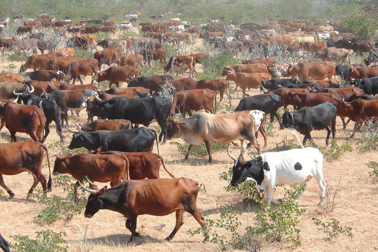
Daily combination of livestock from all households into a single herd to drive to different designated portions of the communal grazing area so that grass may recover to replenish its food reserves before being regrazed some months later.
2.2 การอธิบายแบบละเอียดของเทคโนโลยี
คำอธิบาย:
The technology is currently being applied in communal as well as commercial farms of Namibia. It is particularly effective in areas with no fences and areas with high incidence of stock theft and predator losses. The technology aims to replace continuous grazing with planned grazing which allows recovery of grass plants in the growing season and prepares the soil and grass plants for the upcoming rainy season during the non growing season. In addition fixed carrying capacities are replaced by flexible stocking rates which track availability of forage. Two grazing plans are developed per year, one when perennial grasses are growing and one when they are dormant. The grazing plans may change depending on the season and unanticipated events such as fire. During the growing season a grazing plan is in place that ensures plants are not regrazed before they have recovered their root reserves and that animal performance is good. In the non growing season animal numbers are adjusted to ensure there is sufficient grass to last until rains are reliably expected. Several selections are planned for to ensure animal performance is good.
The grazing plans must take into account all factors that affect the livestock performance as well as the farmer. These factors include first rains, natural pans, animal performance, ensuring good quality forage for cows prior to bulling, poisonous plants, time for vaccinations, where the livestock should be when the farmer is on leave etc. Once the plan has been developed, the animals are herded using low stress handling techniques according to the plan to various parts of the farm or communal grazing area. Moving livestock by herding enables fire breaks to be created by deliberate overtrampling. Each night the livestock are brought back to a kraal where they are kept overnight. Watering of livestock can take place in the kraal at night or in the morning or in the field depending on water availability. This process is repeated day after day.
At the end of each growing season the amount of forage available to the current herd is estimated and animal numbers are adjusted to ‘ensure’ that rains will have been received whilst there is still sufficient forage for the livestock and leaving enough soil cover to feed the soil organisms and protect the soil. Deciding when the forager grown in the last growing season will run out must be done using a method that farmers relate to. Farmers may decide to meet and reach consensus on this based on their knowledge of the effectiveness of rainfall during this season and past experience. If it is decided that there is sufficient food to see the animals through until the next rains can be expected, then farmers have enough forage and may even be able to re-stock if there is a food excess. If however a forage shortage is expected, because too little grass was grown in the last growing season to see them through to the next rains, then de-stocking is needed. The severity of the forage shortage determines how many livestock can be carried on this land during this non-growing season. Again farmers can reach consensus on this. Deciding whose animals to sell and how many is always a thorny issue so farmers will always move excessive animals to other areas if possible or sell unproductive animals first if needed.
2.3 รูปภาพของเทคโนโลยี
อัลบั้มสื่อบันทึก
2.4 วีดีโอของเทคโนโลยี
ความคิดเห็น/อธิบายสั้นๆ:
Combined herding to manage communal grazing
www.youtube.com/watch?v=xNyFkDUH6MQ
วันที่:
2007
สถานที่:
Erora
ชื่อผู้ถ่ายวีดีโอ:
Andrew Botelle
ความคิดเห็น/อธิบายสั้นๆ:
Stress-free herding
www.youtube.com/watch?v=3Ey5v40KtkI
วันที่:
2007
สถานที่:
Erora
ชื่อผู้ถ่ายวีดีโอ:
Andrew Botelle
ความคิดเห็น/อธิบายสั้นๆ:
Managing water flow to repair gully erosion
www.youtube.com/watch?v=6C4V_Cib8ts
วันที่:
23/04/2015
สถานที่:
Erora
ชื่อผู้ถ่ายวีดีโอ:
Andrew Botelle
2.5 ประเทศภูมิภาค หรือสถานที่ตั้งที่เทคโนโลยีได้นำไปใช้และได้รับการครอบคลุมโดยการประเมินนี้
ประเทศ:
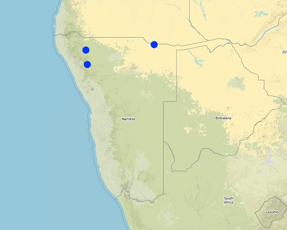
นามิเบีย
ภูมิภาค/รัฐ/จังหวัด:
Kunene Region
ข้อมูลจำเพาะเพิ่มเติมของสถานที่ตั้ง :
Communal grazing areas of Erora, Outokotorua and Nsindi
Map
×2.6 วันที่การดำเนินการ
ระบุปีที่ใช้:
2004
2.7 คำแนะนำของเทคโนโลยี
ให้ระบุว่าเทคโนโลยีถูกแนะนำเข้ามาอย่างไร:
- ทางโครงการหรือจากภายนอก
ความคิดเห็น (ประเภทของโครงการ เป็นต้น) :
Community projects facilitated by NGO "Conservation Agriculture Namibia"
3. การจัดประเภทของเทคโนโลยี SLM
3.1 วัตถุประสงค์หลักของเทคโนโลยี
- ปรับปรุงการผลิตให้ดีขึ้น
- ลด ป้องกัน ฟื้นฟู การเสื่อมโทรมของที่ดิน
- อนุรักษ์ระบบนิเวศน์
- ป้องกันพื้นที่ลุ่มน้ำ/บริเวณท้ายน้ำ โดยร่วมกับเทคโนโลยีอื่นๆ
- รักษาสภาพหรือปรับปรุงความหลากหลายทางชีวภาพ
- ลดความเสี่ยงของภัยพิบัติ
- ปรับตัวเข้ากับการเปลี่ยนแปลงภูมิอากาศของโลก สภาพภูมิอากาศที่รุนแรงและผลกระทบ
- ชะลอการเปลี่ยนแปลงภูมิอากาศของโลกและผลกระทบ
- สร้างผลกระทบทางด้านเศรษฐกิจที่เป็นประโยชน์
- สร้างผลกระทบทางด้านสังคมที่เป็นประโยชน์
- Reduce human-wildlife conflict
3.2 ประเภทของการใช้ที่ดินในปัจจุบันที่ได้นำเทคโนโลยีไปใช้

ทุ่งหญ้าเลี้ยงสัตว์
ทุ่งหญ้าเลี้ยงสัตว์ที่ใช้พื้นที่กว้าง:
- กึ่งเร่ร่อน / อาจมีการทำทุ่งหญ้าเลี้ยงสัตว์ร่วมด้วย (Semi-nomadism/ pastoralism)
ชนิดพันธุ์สัตว์และผลิตภัณฑ์หลัก:
Livestock, increased forage production, improved animal performance
3.3 ข้อมูลเพิ่มเติมเกี่ยวกับการใช้ที่ดิน
การใช้น้ำของที่ดินที่มีการใช้เทคโนโลยีอยู่:
- จากน้ำฝน
จำนวนของฤดูเพาะปลูกต่อปี:
- 1
ความหนาแน่นของปศุสัตว์ (ถ้าเกี่ยวข้อง):
Livestock density is high as a result of herding, but stocking rate varies
3.4 กลุ่ม SLM ที่ตรงกับเทคโนโลยีนี้
- การจัดการปศุสัตว์และทุ่งหญ้าเลี้ยงสัตว์
3.5 กระจายตัวของเทคโนโลยี
ระบุการกระจายตัวของเทคโนโลยี:
- กระจายไปอย่างสม่ำเสมอในพื้นที่
ถ้าหากว่าเทคโนโลยีได้มีการกระจายออกไปอย่างสม่ำเสมอในพื้นที่ ให้ระบุปริมาณพื้นที่ที่ได้รับการครอบคลุมถึง:
- 100-1,000 ตร.กม.
แสดงความคิดเห็น:
Animals are herded over the entire area – except areas that are too steep for livestock to walk up.
3.6 มาตรการ SLM ที่ประกอบกันเป็นเทคโนโลยี

มาตรการอนุรักษ์ด้วยการจัดการ
- M4: การเปลี่ยนแปลงช่วงเวลาให้เหมาะแก่การทำกิจกรรม
แสดงความคิดเห็น:
The technology does not involve a change in land use. The grazing plan means that livestock will only be on a particular piece of land twice in any given year (once in the growing season and once in the non growing season). The animal density is however high, leading to increased impact for a very short period.
3.7 รูปแบบหลักของการเสื่อมโทรมของที่ดินที่ได้รับการแก้ไขโดยเทคโนโลยี

การกัดกร่อนของดินโดยน้ำ
- Wt (Loss of topsoil): การสูญเสียดินชั้นบนหรือการกัดกร่อนที่ผิวดิน
- Wg (Gully erosion): การกัดกร่อนแบบร่องธารหรือการทำให้เกิดร่องน้ำเซาะ
- Wo (Offsite degradation): ผลกระทบนอกพื้นที่

การกัดกร่อนของดินโดยลม
- Et (Loss of topsoil): การสูญเสียดินชั้นบน

การเสื่อมโทรมของดินทางด้านกายภาพ
- Pk (Slaking and crusting): การอุดตันของช่องว่างในดินหรือรูพรุน

การเสื่อมโทรมของดินทางด้านชีวภาพ
- Bc (Reduction of vegetation cover): การลดลงของจำนวนพืชที่ปกคลุมดิน
- Bq (Quantity/biomass decline): การลดลงของปริมาณหรือมวลชีวภาพ
- Bs (Quality and species composition): องค์ประกอบหรือความหลากหลายทางคุณภาพและชนิดพันธุ์ลดลง
- Bl (Loss of soil life): การสูญเสียสิ่งมีชีวิตในดิน

การเสื่อมโทรมของน้ำ
- Ha (Aridification): การเกิดความแห้งแล้ง
- Hs (Change in quantity of surface water): การเปลี่ยนแปลงปริมาณของน้ำที่ผิวดิน
- Hg (Change in groundwater): การเปลี่ยนแปลงของน้ำบาดาลหรือระดับน้ำในแอ่งน้ำบาดาล
แสดงความคิดเห็น:
The control of over-trampling which otherwise leads to rill and gulley erosion
3.8 การป้องกัน การลดลง หรือการฟื้นฟูความเสื่อมโทรมของที่ดิน
ระบุเป้าหมายของเทคโนโลยีกับความเสื่อมโทรมของที่ดิน:
- ฟื้นฟูบำบัดที่ดินที่เสื่อมโทรมลงอย่างมาก
แสดงความคิดเห็น:
Land is severely degraded but can be restored by change in management
4. ข้อมูลจำเพาะด้านเทคนิค กิจกรรมการนำไปปฏิบัติใช้ ปัจจัยนำเข้า และค่าใช้จ่าย
4.1 แบบแปลนทางเทคนิคของเทคโนโลยี
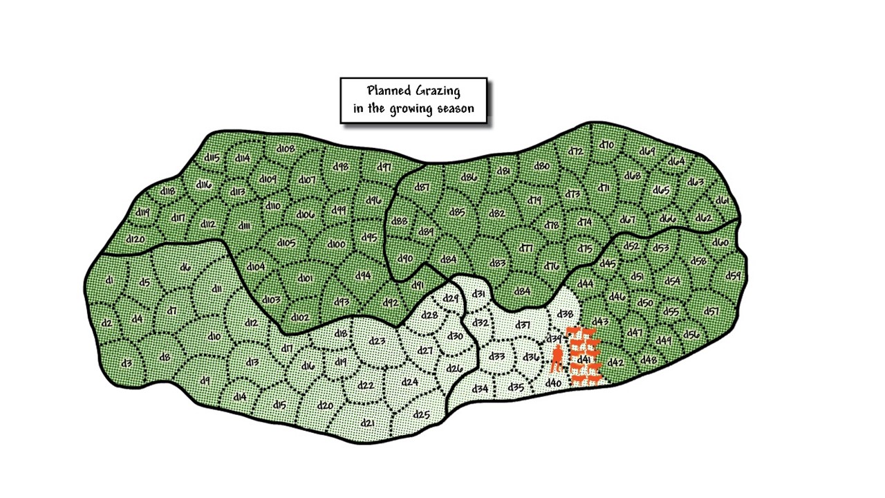
ผู้เขียน:
Colin Nott
4.2 ข้อมูลจำเพาะด้านเทคนิคและการอธิบายแบบแปลนทางเทคนิค
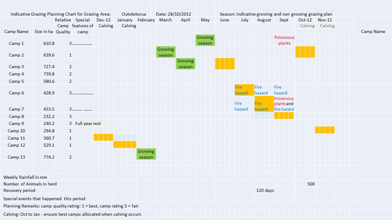
Schematic diagram of planned grazing of a growing season grazing plan. In this diagram grazing started in the bottom left hand camp, marked d1, and the livestock were grazed in this area for this day. The next day the herd of livestock were taken to the area marked d2 and grazed there. This continued until day 41 where the livestock are currently. If deviations from plan occur then the actual grazing map is marked according to what actually happened. This is the map that helps inform next year's grazing plan to avoid using certain camps at the same time of year. The degree of greenness in the diagram indicates the amount of recovery of grass since being grazed. It is lightest in the area just grazed, marked d40. By the time the herd reaches day 120, which has the darkest green indicating readiness to be re-grazed, then the grass in the area marked d1 was planned to have recovered sufficiently to be regrazed. This plan has a built in recovery period of 120 days. It is possible that growth rates are slower than expected and it may be necessary to reduce numbers of cattle in the herd to slow down the movement to ensure the desired recovery period is achieved.
4.3 ข้อมูลทั่วไปเกี่ยวกับการคำนวณปัจจัยนำเข้าและค่าใช้จ่าย
ให้ระบุว่าค่าใช้จ่ายและปัจจัยนำเข้าได้รับการคำนวณอย่างไร:
- ต่อพื้นที่ที่ใช้เทคโนโลยี
ระบุขนาดและหน่วยพื้นที่:
5000 ha
ระบุสกุลเงินที่ใช้คำนวณค่าใช้จ่าย:
- ดอลลาร์สหรัฐ
ระบุค่าเฉลี่ยของค่าจ้างในการจ้างแรงงานต่อวัน:
USD 4
4.4 กิจกรรมเพื่อการจัดตั้ง
| กิจกรรม | ประเภทของมาตรการ | ช่วงเวลาดำเนินการ | |
|---|---|---|---|
| 1. | Three meetings for mobilisation of communities | ด้วยการจัดการ | Month 1 |
| 2. | Exchange visit to local farmers using this practise | ด้วยการจัดการ | Month 4 |
| 3. | Assess water infrastructure, site and drill and install additional water point | ด้วยโครงสร้าง | Month 6 |
| 4. | Grazing planning meeting with stakeholders | ด้วยการจัดการ | After adequate grass growth to enable planned grazing |
| 5. | Appoint, equip and train herders | ด้วยการจัดการ | After 4 |
| 6. | Planning meeting and determination of starting date | ด้วยการจัดการ | After 5 |
| 7. | Build overnight kraals at new water points | ด้วยโครงสร้าง | When needed |
| 8. | Build temporary kraals for improved grass growth | ด้วยโครงสร้าง | When needed |
4.5 ค่าใช้จ่ายของปัจจัยนำเข้าที่จำเป็นสำหรับการจัดตั้ง
| ปัจจัยนำเข้า | หน่วย | ปริมาณ | ค่าใช้จ่ายต่อหน่วย | ค่าใช้จ่ายทั้งหมดต่อปัจจัยนำเข้า | %ของค่าใช้จ่ายที่ก่อให้เกิดขึ้นโดยผู้ใช้ที่ดิน | |
|---|---|---|---|---|---|---|
| แรงงาน | Six herders (four on duty per day) for 400 cattle | Months | 6.0 | 77.0 | 462.0 | 100.0 |
| แรงงาน | One manager | Month | 1.0 | 115.0 | 115.0 | 100.0 |
| อุปกรณ์ | Overalls, boots and hat that may need replacement after one year | Set | 7.0 | 100.0 | 700.0 | 100.0 |
| วัสดุสำหรับก่อสร้าง | Housing for herders built from mud and dung | Shelter | 3.0 | 100.0 | 300.0 | 100.0 |
| อื่น ๆ | Laminated grazing chart and map per year | Document | 2.0 | 10.0 | 20.0 | |
| ค่าใช้จ่ายทั้งหมดของการจัดตั้งเทคโนโลยี | 1597.0 | |||||
ถ้าผู้ใช้ที่ดินรับภาระน้อยกว่า 100% ของค่าใช้จ่าย ให้ระบุว่าใครเป็นผู้รับผิดชอบส่วนที่เหลือ:
Grazing maps and charts prodcuded by CAN (support NGO), but will be taken over soon by farmers
4.6 การบำรุงรักษาสภาพหรือกิจกรรมที่เกิดขึ้นเป็นประจำ
| กิจกรรม | ประเภทของมาตรการ | ช่วงระยะเวลา/ความถี่ | |
|---|---|---|---|
| 1. | Daily herding, watering of livestock and health checks and treatment | ด้วยการจัดการ | Daily |
| 2. | Maintenance of kraals and water points | ด้วยโครงสร้าง | Quartery |
4.7 ค่าใช้จ่ายของปัจจัยนำเข้าและกิจกรรมที่เกิดขึ้นเป็นประจำที่ต้องการการบำรุงรักษา (ต่อปี)
| ปัจจัยนำเข้า | หน่วย | ปริมาณ | ค่าใช้จ่ายต่อหน่วย | ค่าใช้จ่ายทั้งหมดต่อปัจจัยนำเข้า | %ของค่าใช้จ่ายที่ก่อให้เกิดขึ้นโดยผู้ใช้ที่ดิน | |
|---|---|---|---|---|---|---|
| แรงงาน | Six herders (four on duty per day) for 400 cattle | Months | 6.0 | 77.0 | 462.0 | 100.0 |
| แรงงาน | One manager | Month | 1.0 | 115.0 | 115.0 | 100.0 |
| อุปกรณ์ | Overalls, boots and hat, replaced annually | Set | 7.0 | 100.0 | 700.0 | 100.0 |
| วัสดุสำหรับก่อสร้าง | Maintenance of clay and dung housing for herders | Shelters | 3.0 | 100.0 | 300.0 | 100.0 |
| อื่น ๆ | Diesel for pumping water per month | Litres | 100.0 | 1.0 | 100.0 | 100.0 |
| อื่น ๆ | Laminated grazing chart and map per year | Documents | 2.0 | 10.0 | 20.0 | 100.0 |
| ค่าใช้จ่ายทั้งหมดของการบำรุงรักษาสภาพเทคโนโลยี | 1697.0 | |||||
4.8 ปัจจัยสำคัญที่สุดที่มีผลกระทบต่อค่าใช้จ่าย
ปัจจัยสำคัญที่สุดที่มีผลกระทบต่อค่าใช้จ่ายต่างๆ:
Appreciation by land users that investment in herders will pay back, especially from the second year onwards.
5. สิ่งแวดล้อมทางธรรมชาติและของมนุษย์
5.1 ภูมิอากาศ
ฝนประจำปี
- < 250 ม.ม.
- 251-500 ม.ม.
- 501-750 ม.ม.
- 751-1,000 ม.ม.
- 1,001-1,500 ม.ม.
- 1,501-2,000 ม.ม.
- 2,001-3,000 ม.ม.
- 3,001-4,000 ม.ม.
- > 4,000 ม.ม.
ข้อมูลจำเพาะ/ความคิดเห็นเรื่องปริมาณน้ำฝน:
Summer rainfall December-March
ระบุชื่อของสถานีตรวดวัดอากาศที่ใช้อ้างอิงคือ:
Opuwo
เขตภูมิอากาศเกษตร
- แห้งแล้ง
5.2 สภาพภูมิประเทศ
ค่าเฉลี่ยความลาดชัน:
- ราบเรียบ (0-2%)
- ลาดที่ไม่ชัน (3-5%)
- ปานกลาง (6-10%)
- เป็นลูกคลื่น (11-15%)
- เป็นเนิน (16-30%)
- ชัน (31-60%)
- ชันมาก (>60%)
ธรณีสัณฐาน:
- ที่ราบสูง/ที่ราบ
- สันเขา
- ไหล่เขา
- ไหล่เนินเขา
- ตีนเนิน
- หุบเขา
ระดับความสูง:
- 0-100 เมตร
- 101-500 เมตร
- 501-1,000 เมตร
- 1,001-1,500 เมตร
- 1,501-2,000 เมตร
- 2,001-2,500 เมตร
- 2,501-3,000 เมตร
- 3,001-4,000 เมตร
- > 4,000 เมตร
ให้ระบุถ้าเทคโนโลยีได้ถูกนำไปใช้:
- ไม่เกี่ยวข้อง
5.3 ดิน
ค่าเฉลี่ยความลึกของดิน:
- ตื้นมาก (0-20 ซ.ม.)
- ตื้น (21-50 ซ.ม.)
- ลึกปานกลาง (51-80 ซ.ม.)
- ลึก (81-120 ซ.ม.)
- ลึกมาก (>120 ซ.ม.)
เนื้อดิน (ดินชั้นบน):
- หยาบ/เบา (ดินทราย)
เนื้อดินล่าง (> 20 ซ.ม.ต่ำจากผิวดิน):
- ปานกลาง (ดินร่วน ทรายแป้ง)
อินทรียวัตถุในดิน:
- ต่ำ (<1%)
5.4 ความเป็นประโยชน์และคุณภาพของน้ำ
ระดับน้ำใต้ดิน:
> 50 เมตร
น้ำไหลบ่าที่ผิวดิน:
ปานกลาง
คุณภาพน้ำ (ที่ยังไม่ได้บำบัด):
เป็นน้ำเพื่อการดื่มที่ดี
ความเค็มของน้ำเป็นปัญหาหรือไม่:
ไม่ใช่
กำลังเกิดน้ำท่วมในพื้นที่หรือไม่:
ใช่
บ่อยครั้ง:
เป็นครั้งเป็นคราว
5.5 ความหลากหลายทางชีวภาพ
ความหลากหลายทางชนิดพันธุ์:
- ปานกลาง
ความหลากหลายของแหล่งที่อยู่:
- ปานกลาง
5.6 ลักษณะของผู้ใช้ที่ดินที่นำเทคโนโลยีไปปฏิบัติใช้
อยู่กับที่หรือเร่ร่อน:
- อยู่กับที่
- กึ่งเร่ร่อน
แนวทางการตลาดของระบบการผลิต:
- ผสม (การเลี้ยงชีพ/ทำการค้า)
รายได้ที่มาจากนอกฟาร์ม:
- 10-50% ของรายได้ทั้งหมด
ระดับของความมั่งคั่งโดยเปรียบเทียบ:
- พอมีพอกิน
เป็นรายบุคคล/ครัวเรือน:
- กลุ่ม/ชุมชน
ระดับของการใช้เครื่องจักรกล:
- งานที่ใช้แรงกาย
เพศ:
- หญิง
- ชาย
อายุของผู้ใช้ที่ดิน:
- วัยกลางคน
ระบุลักษณะอื่นๆที่เกี่ยวข้องของผู้ใช้ที่ดิน:
In dry years all livestock may move to another cattle post. But they return to the sedentary site as their main grazing area. A significant number of land users take up employment in the nearest town.
5.7 พื้นที่เฉลี่ยของที่ดินที่เป็นเจ้าของหรือเช่าโดยผู้ใช้ที่ดินที่นำเทคโนโลยีไปปฏิบัติใช้
- < 0.5 เฮกตาร์
- 0.5-1 เฮกตาร์
- 1-2 เฮกตาร์
- 2-5 เฮกตาร์
- 5-15 เฮกตาร์
- 15-50 เฮกตาร์
- 50-100 เฮกตาร์
- 100-500 เฮกตาร์
- 500-1,000 เฮกตาร์
- 1,000-10,000 เฮกตาร์
- >10,000 เฮกตาร์
พิจารณาว่าเป็นขนาดเล็ก กลาง หรือขนาดใหญ่ (ซึ่งอ้างอิงถึงบริบทระดับท้องถิ่น):
- ขนาดกลาง
แสดงความคิดเห็น:
Communal land is not owned or leased, but the community has rights to use it for agricultural purposes
5.8 กรรมสิทธิ์ในที่ดิน สิทธิในการใช้ที่ดินและสิทธิในการใช้น้ำ
กรรมสิทธิ์ในที่ดิน:
- รัฐ
สิทธิในการใช้ที่ดิน:
- เกี่ยวกับชุมชน (ถูกจัดระเบียบ)
สิทธิในการใช้น้ำ:
- เกี่ยวกับชุมชน (ถูกจัดระเบียบ)
แสดงความคิดเห็น:
Land is communal and organised but no rights to enforce management are yet in place through formal structures.
5.9 การเข้าถึงบริการและโครงสร้างพื้นฐาน
สุขภาพ:
- จน
- ปานกลาง
- ดี
การศึกษา:
- จน
- ปานกลาง
- ดี
ความช่วยเหลือทางด้านเทคนิค:
- จน
- ปานกลาง
- ดี
การจ้างงาน (เช่น ภายนอกฟาร์ม):
- จน
- ปานกลาง
- ดี
ตลาด:
- จน
- ปานกลาง
- ดี
พลังงาน:
- จน
- ปานกลาง
- ดี
ถนนและการขนส่ง:
- จน
- ปานกลาง
- ดี
น้ำดื่มและการสุขาภิบาล:
- จน
- ปานกลาง
- ดี
บริการด้านการเงิน:
- จน
- ปานกลาง
- ดี
6. ผลกระทบและสรุปคำบอกกล่าว
6.1 ผลกระทบในพื้นที่ดำเนินการ (On-site) จากการใช้เทคโนโลยี
ผลกระทบทางด้านเศรษฐกิจและสังคม
การผลิต
การผลิตพืชที่ใช้เลี้ยงปศุสัตว์
การผลิตสัตว์
การเสี่ยงต่อความล้มเหลวในการผลิต
การจัดการที่ดิน
แสดงความคิดเห็น/ระบุ:
Improved, not simplified
ความเป็นประโยชน์และคุณภาพของน้ำ
การมีน้ำไว้ให้ปศุสัตว์
รายได้และค่าใช้จ่าย
ค่าใช่จ่ายของปัจจัยการผลิตทางการเกษตร
รายได้จากฟาร์ม
ความเหลื่อมล้ำทางเศรษฐกิจ
ภาระงาน
ผลกระทบด้านสังคมวัฒนธรรมอื่น ๆ
ความมั่นคงด้านอาหาร / พึ่งตนเองได้
การใช้ที่ดิน / สิทธิในการใช้น้ำ
สถาบันของชุมชน
SLM หรือความรู้เรื่องความเสื่อมโทรมของที่ดิน
การบรรเทาความขัดแย้ง
ผลกระทบด้านนิเวศวิทยา
วัฐจักรน้ำหรือน้ำบ่า
น้ำไหลบ่าที่ผิวดิน
การระเหย
ดิน
ความชื้นในดิน
สิ่งปกคลุมดิน
การสูญเสียดิน
การเกิดแผ่นแข็งที่ผิวดิน /การเกิดชั้นดาน
การหมุนเวียนและการเติมของธาตุอาหาร
ความหลากหลายทางชีวภาพของพืชและสัตว์
การปกคลุมด้วยพืช
ความหลากหลายทางชีวภาพของพืช
ความหลากหลายทางชีวภาพของสัตว์
ลดความเสี่ยงของภัยพิบัติ
ผลกระทบจากภัยแล้ง
ความเสี่ยงจากไฟ
ภูมิอากาศจุลภาค
6.2 ผลกระทบนอกพื้นที่ดำเนินการ (Off-site) จากการใช้เทคโนโลยี
Community's cattle no longer graze on land of neighbouring communities
6.3 การเผชิญและความตอบสนองของเทคโนโลยีต่อการเปลี่ยนแปลงสภาพภูมิอากาศที่ค่อยเป็นค่อยไป และสภาพรุนแรงของภูมิอากาศ / ภัยพิบัติ (ที่รับรู้ได้โดยผู้ใช้ที่ดิน)
การเปลี่ยนแปลงสภาพภูมิอากาศที่ค่อยเป็นค่อยไป
การเปลี่ยนแปลงสภาพภูมิอากาศที่ค่อยเป็นค่อยไป
| ฤดู | ประเภทของการเปลี่ยนแปลงสภาพภูมิอากาศที่ค่อยเป็นค่อยไป และสภาพรุนแรงของภูมิอากาศ | เทคโนโลยีมีวิธีการรับมืออย่างไร | |
|---|---|---|---|
| อุณหภูมิประจำปี | เพิ่มขึ้น | ปานกลาง | |
| ฝนประจำปี | ลดลง | ปานกลาง |
สภาพรุนแรงของภูมิอากาศ (ภัยพิบัติ)
ภัยพิบัติทางอุตุนิยมวิทยา
| เทคโนโลยีมีวิธีการรับมืออย่างไร | |
|---|---|
| พายุฝนฟ้าคะนองประจำท้องถิ่น | ดี |
ภัยพิบัติจากสภาพภูมิอากาศ
| เทคโนโลยีมีวิธีการรับมืออย่างไร | |
|---|---|
| ภัยจากฝนแล้ง | ปานกลาง |
| ไฟบนบก | ดี |
6.4 การวิเคราะห์ค่าใช้จ่ายและผลประโยชน์ที่ได้รับ
ผลประโยชน์ที่ได้รับเปรียบเทียบกับค่าใช้จ่ายในการจัดตั้งเป็นอย่างไร (จากมุมมองของผู้ใช้ที่ดิน)
ผลตอบแทนระยะสั้น:
ด้านบวก
ผลตอบแทนระยะยาว:
ด้านบวกอย่างมาก
ผลประโยชน์ที่ได้รับเปรียบเทียบกับค่าใช้จ่ายในการบำรุงรักษาหรือต้นทุนที่เกิดขึ้นซ้ำอีก เป็นอย่างไร (จากมุมมองของผู้ใช้ที่ดิน)
ผลตอบแทนระยะสั้น:
ด้านบวกอย่างมาก
ผลตอบแทนระยะยาว:
ด้านบวกอย่างมาก
แสดงความคิดเห็น:
The ability to bring back perennial grasses results in higher stocking rates, less drought risk and better quality animals, therefore higher income over time and therefore a good cost benefit analysis.
6.5 การปรับตัวของเทคโนโลยี
- 1-10%
ถ้ามีข้อมูลให้บอกปริมาณด้วย (จำนวนของครัวเรือนหรือครอบคลุมพื้นที่):
20,000 ha
จากทั้งหมดที่ได้รับเทคโนโลยีเข้ามามีจำนวนเท่าใดที่ทำแบบทันที โดยไม่ได้รับการจูงใจด้านวัสดุหรือการเงินใด ๆ:
- 0-10%
แสดงความคิดเห็น:
This is a key issue undergoing lobbying of government and the communal farmers union to establish through a consultative process legislation that enables grazing plans to be enforced from within and from outside. This is lacking at the moment.
6.6 การปรับตัว
เทคโนโลยีได้รับการปรับเปลี่ยนเมื่อเร็วๆนี้ เพื่อให้ปรับตัวเข้ากับสภาพที่กำลังเปลี่ยนแปลงหรือไม่:
ใช่
อื่น ๆ (ระบุ):
Adaptive management
ให้ระบุการปรับตัวของเทคโนโลยี (การออกแบบ วัสดุหรือชนิดพันธุ์ เป็นต้น):
Addition of erosion control and overnight kraaling to assist with gully control. Refining re-planning in response to monitored results that show deviation from aims.
6.7 จุดแข็ง / ข้อได้เปรียบ / โอกาสของเทคโนโลยี
| จุดแข็ง / ข้อได้เปรียบ / โอกาสในทัศนคติของผู้ใช้ที่ดิน |
|---|
| It is cost effective, real improvement is seen in grass production while livestock losses to predators are significantly reduced. |
| For absentee owners they can leave a manager and herders in place to get on with the work and this can be easily evaluated after time since animals wondering around leave evidence. |
| Livestock are better cared for as they used to be and a sense of community has been restored. |
| จุดแข็ง / ข้อได้เปรียบ / โอกาสในทัศนคติของผู้รวบรวมหรือวิทยากรหลัก |
|---|
| This is a viable and upscaleable technology for both communal and commercial farmland in Namibia and beyond. |
| It addresses the root cause of livestock related degradation and at a global scale can have a significant impact on mitigating climate change if all the degraded rangelands of the dry climates of the world are restored by using the principles embodied in this approach – which has been adopted in the National Rangeland Management Policy and Strategy. Moreover it can improve the quality of lives of millions of people who live in areas where livestock is the only viable land use. |
| This is a true triple bottom line technology that improves the resource base whilst increasing profits and enbables an improved quality of life of residents. |
6.8 จุดอ่อน / ข้อเสียเปรียบ / ความเสี่ยงของเทคโนโลยีและวิธีการแก้ไข
| จุดอ่อน / ข้อเสียเปรียบ / ความเสี่ยงในทัศนคติของผู้ใช้ที่ดิน | มีวิธีการแก้ไขได้อย่างไร |
|---|---|
| Herders are difficult to find, train and keep. | National level vocational training of herders is required. |
| Water infrastructure tends to result in overtrampling of the same routes. | The Directorate of Rural Water Supply should change its water specifications to include the provision of water for livestock – which can be cheap and effective. |
| Grass poaching takes place by neighbours and the majority will of people in an area is sometimes overrun by a small minority. | Farmers Unions must address these issues and get enforceable mechanisms in place for improved rangeland management. |
| จุดอ่อน / ข้อเสียเปรียบ / ความเสี่ยงในทัศนคติของผู้รวบรวมหรือวิทยากรหลัก | มีวิธีการแก้ไขได้อย่างไร |
|---|---|
| There is insufficient national buy-in from line ministries in terms of implementation to address many of the issues that have been raised. | Line ministries should support implementation to address these problems. Joint implementation, joint review and adaptation by government, unions, farmers and support providers will assist in solving many issues for resource base improvement. |
7. การอ้างอิงและการเชื่อมต่อ
7.1 วิธีการและแหล่งข้อมูล
- การสัมภาษณ์ผู้เชี่ยวชาญด้าน SLM หรือผู้ชำนาญ
7.2 การอ้างอิงถึงสิ่งตีพิมพ์
หัวข้อ, ผู้เขียน, ปี, หมายเลข ISBN:
Holistic mangement, Savory, A. & Butterfield, J., 1991
ชื่อเรื่อง ผู้เขียน ปี ISBN:
Island Press
7.3 เชื่อมโยงกับข้อมูลที่มีอยู่บนออนไลน์
ชื่อเรื่องหรือคำอธิบาย:
Volkmann, W. (2011). Community based rangeland and livestock management. Windhoek: GOPA-CBRLM.
URL:
https://rmportal.net/groups/cbrlm/cbrlm-for-review/namibia-community-based-rangeland-livestock-management-cbrlm-2nd-edition/view
ลิงก์และโมดูล
ขยายทั้งหมด ย่อทั้งหมดลิงก์
ไม่มีลิงก์
โมดูล
ไม่มีโมดูล