Staggered Contour Trench [อัฟกานิสถาน]
- ผู้สร้างสรรค์:
- การอัพเดท:
- ผู้รวบรวม: Aqila Haidery
- ผู้เรียบเรียง: –
- ผู้ตรวจสอบ: Alexandra Gavilano
Jerma (Dari)
technologies_1715 - อัฟกานิสถาน
ดูส่วนย่อย
ขยายทั้งหมด ย่อทั้งหมด1. ข้อมูลทั่วไป
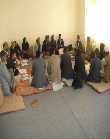
1.2 รายละเอียดที่ติดต่อได้ของผู้รวบรวมและองค์กรที่เกี่ยวข้องในการประเมินและการจัดเตรียมทำเอกสารของเทคโนโลยี
ผู้เชี่ยวชาญ SLM:
ผู้เชี่ยวชาญ SLM:
ผู้เชี่ยวชาญ SLM:
ผู้เชี่ยวชาญ SLM:
ผู้เชี่ยวชาญ SLM:
Sirat Aliaver
AKF
อัฟกานิสถาน
ผู้เชี่ยวชาญ SLM:
Altaf Jalil
AKF
อัฟกานิสถาน
ชื่อของโครงการซึ่งอำนวยความสะดวกในการทำเอกสารหรือการประเมินเทคโนโลยี (ถ้าเกี่ยวข้อง)
Sustainable Land Management Project, Bhutan (SLMP)ชื่อขององค์กรซึ่งอำนวยความสะดวกในการทำเอกสารหรือการประเมินเทคโนโลยี (ถ้าเกี่ยวข้อง)
HELVETAS (Swiss Intercooperation)ชื่อขององค์กรซึ่งอำนวยความสะดวกในการทำเอกสารหรือการประเมินเทคโนโลยี (ถ้าเกี่ยวข้อง)
Aga Khan Foundation (AKF) - สวิตเซอร์แลนด์ชื่อขององค์กรซึ่งอำนวยความสะดวกในการทำเอกสารหรือการประเมินเทคโนโลยี (ถ้าเกี่ยวข้อง)
Sustainable Land Management Institute Organistatio (Sustainable Land Management Institute Organistatio) - อัฟกานิสถาน1.3 เงื่อนไขการใช้ข้อมูลที่ได้บันทึกผ่านทาง WOCAT
ผู้รวบรวมและวิทยากรหลักยอมรับเงื่อนไขเกี่ยวกับการใช้ข้อมูลที่ถูกบันทึกผ่านทาง WOCAT:
ใช่
1.5 Reference to Questionnaire(s) on SLM Approaches (documented using WOCAT)
Community-based Natural Resource Management [อัฟกานิสถาน]
An approach to community participation in the sustainable management of natural resources
- ผู้รวบรวม: Aqila Haidery
2. การอธิบายลักษณะของเทคโนโลยี SLM
2.1 การอธิบายแบบสั้น ๆ ของเทคโนโลยี
คำจำกัดความของเทคโนโลยี:
Earthen trenches with soil bunds built along contours in staggered design
2.2 การอธิบายแบบละเอียดของเทคโนโลยี
คำอธิบาย:
The SCTs technology is documented by Sustainable Land Management Project/HELVETAS Swiss Intercooperation which is funded by Swiss Agency for Development and Cooperation (SDC), with close support and cooperation of the Agha Khan Foundation (AKF). The staggered Contour Trenches (SCTs) were constructed at a degraded site in Bamyan center (Bamyan province) by Agha Khan Foundation (AKF) project with financial support of the Canadian International Development Agency (CIDA).
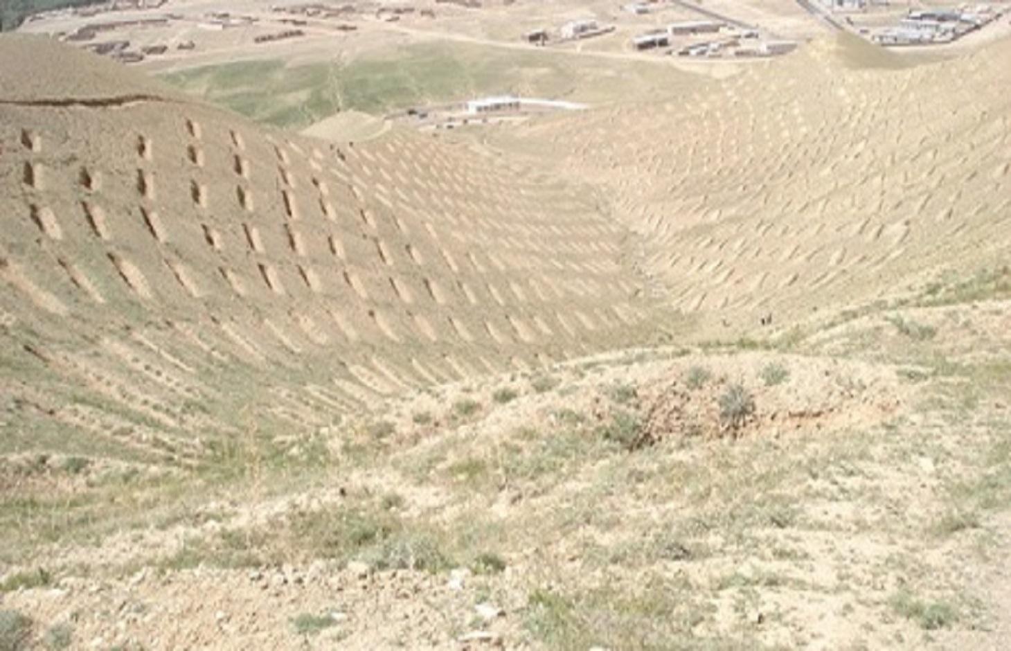
Totally 1470 contour trenches were constructed at the site, which has an area of 24 hectares.
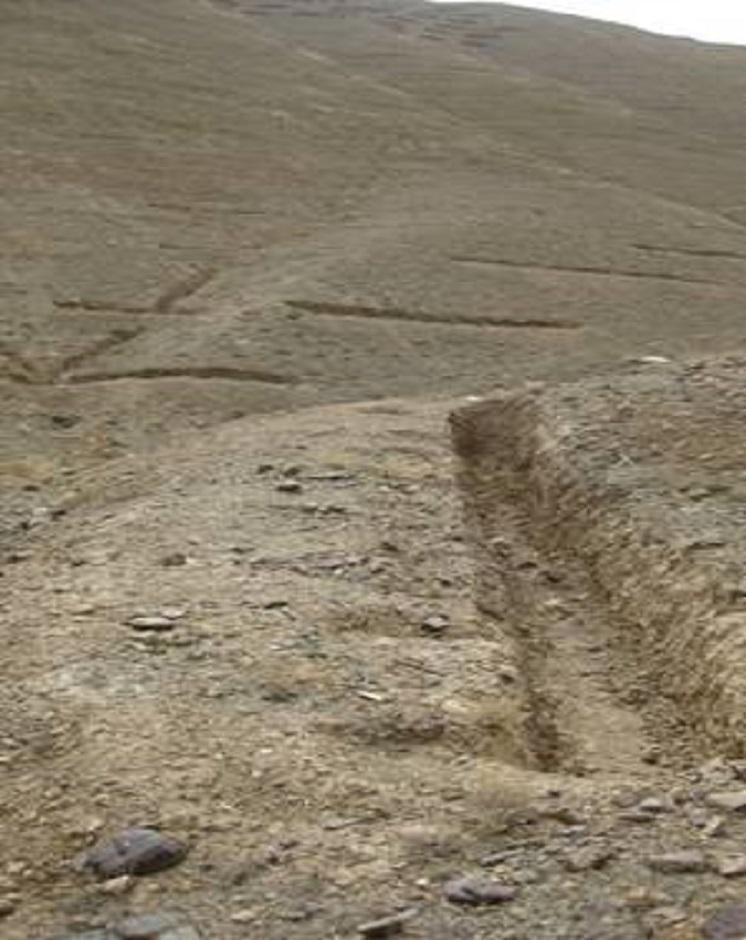
The size of each trench measured 10 m in length, 0.6 m in width and 0.5 m in depth. The trenches had soil bunds on the lower side having a width of 1 m and height of 0.3 m. Contour lines were prepared using an A-frame and lime and the spacing between two contour lines was 8 m considering the slope. All the trenches were dug out manually. Local people were employed for construction works. Along with the SCTs, other measures were applied such as plantation of fodder grass, shrub and non-fruit trees, gully plugs, water harvesting tanks and brushwood plugs. The area is excluded from grazing and shrub cutting.
The land was extensive grazing land before the project implementation and got extremely degraded due to a lack of management by the land users. There was rampant exploitation of natural vegetation for meeting domestic energy needs and for grazing. Droughts, which frequently occur in the region, contributed to the slow degradation of the vegetation.
Purpose of the Technology: The main purpose of the technology is to reduce flash flood risks and improve land productivity (both upstream and downstream) so that more fodder, fuel wood and fruits could be produced and farmers affected by flash floods could grow more crops. The technology, which is part of a watershed technology system, helps in retaining runoff and sediment and improves soil moisture content. It also helps in water infiltration which eventually contributes to improved ground water recharge.
Establishment / maintenance activities and inputs: SCTs were established in a step-wise manner; as follows: (1) Site surveying, (2) Site mapping, (3) Planning, (4) Marking contour lines with the help of an A-frame, and (5) Trench excavation and bund construction.
The establishment cost for staggered contour trenches, was about 15,500 USD or 645 USD/ha. Most of the money was spent on labour. There have been no expenses in maintenance of SCTs since their establishment in 2008.
Natural / human environment: The technology is applied in semi-arid condition as the area receives annual rainfall of about 400 mm to address land degradation. The site formally belonged to the state but the local communities have use rights. AKF is still maintaining the site and using it for training and demonstration purpose. Several exposure visits for SLM specialist, land users, students and teachers have been also organized at the site.
2.3 รูปภาพของเทคโนโลยี
อัลบั้มสื่อบันทึก
2.5 ประเทศภูมิภาค หรือสถานที่ตั้งที่เทคโนโลยีได้นำไปใช้และได้รับการครอบคลุมโดยการประเมินนี้
ประเทศ:
อัฟกานิสถาน
ภูมิภาค/รัฐ/จังหวัด:
Zai Mahmood village, Bamyan center, Afghanistan
ระบุการกระจายตัวของเทคโนโลยี:
- กระจายไปอย่างสม่ำเสมอในพื้นที่
If precise area is not known, indicate approximate area covered:
- 0.1-1 ตร.กม.
แสดงความคิดเห็น:
Total area covered by the SLM Technology is 0.24 km2.
2.6 วันที่การดำเนินการ
ถ้าไม่รู้ปีที่แน่นอน ให้ระบุวันที่โดยประมาณ:
- น้อยกว่า 10 ปี (ไม่นานนี้)
2.7 คำแนะนำของเทคโนโลยี
ให้ระบุว่าเทคโนโลยีถูกแนะนำเข้ามาอย่างไร:
- ทางโครงการหรือจากภายนอก
3. การจัดประเภทของเทคโนโลยี SLM
3.1 วัตถุประสงค์หลักของเทคโนโลยี
- ปรับปรุงการผลิตให้ดีขึ้น
- ลดความเสี่ยงของภัยพิบัติ
3.2 ประเภทของการใช้ที่ดินในปัจจุบันที่ได้นำเทคโนโลยีไปใช้

ทุ่งหญ้าเลี้ยงสัตว์

ป่า/พื้นที่ทำไม้
- ป่า/พื้นที่ทำไม้
แสดงความคิดเห็น:
Major land use problems (compiler’s opinion): Flash floods, gully/rill/sheet erosion, loss of natural vegetation and low productivity of the land due to degradation compounded by climatic factors.
Major land use problems (land users’ perception): Declining productivity of land resulting in shortages of fodder and fuel wood and loss of fertile land in the downstream areas due to flash floods.
Grazingland comments: The area is closed for livestock.
Future (final) land use (after implementation of SLM Technology): Forests / woodlands: Fp: Plantations, afforestations
Type of grazing system comments: The area is closed for livestock.
Number of growing seasons per year: 1
Longest growing period in days: 180; Longest growing period from month to month: April to September
Livestock density: 1-10 LU /km2
3.3 Has land use changed due to the implementation of the Technology?
ทุ่งหญ้าเลี้ยงสัตว์
- Extensive grazing
3.5 กลุ่ม SLM ที่ตรงกับเทคโนโลยีนี้
- การปิดล้อมพื้นที่ (หยุดการใช้ประโยชน์ สนับสนุนการฟื้นฟู)
- มาตรการปลูกพืชขวางความลาดชัน (cross-slope measure)
- การจัดการน้ำบาดาล
3.6 มาตรการ SLM ที่ประกอบกันเป็นเทคโนโลยี

มาตรการอนุรักษ์ด้วยโครงสร้าง
- S4: คูน้ำแนวระดับ หลุม
3.7 รูปแบบหลักของการเสื่อมโทรมของที่ดินที่ได้รับการแก้ไขโดยเทคโนโลยี

การกัดกร่อนของดินโดยน้ำ
- Wt (Loss of topsoil): การสูญเสียดินชั้นบนหรือการกัดกร่อนที่ผิวดิน

การเสื่อมโทรมของดินทางด้านชีวภาพ
- Bc (Reduction of vegetation cover): การลดลงของจำนวนพืชที่ปกคลุมดิน

การเสื่อมโทรมของน้ำ
- Hs (Change in quantity of surface water): การเปลี่ยนแปลงปริมาณของน้ำที่ผิวดิน
แสดงความคิดเห็น:
Main causes of degradation: deforestation / removal of natural vegetation (incl. forest fires), over-exploitation of vegetation for domestic use, overgrazing
3.8 การป้องกัน การลดลง หรือการฟื้นฟูความเสื่อมโทรมของที่ดิน
ระบุเป้าหมายของเทคโนโลยีกับความเสื่อมโทรมของที่ดิน:
- ลดความเสื่อมโทรมของดิน
4. ข้อมูลจำเพาะด้านเทคนิค กิจกรรมการนำไปปฏิบัติใช้ ปัจจัยนำเข้า และค่าใช้จ่าย
4.1 แบบแปลนทางเทคนิคของเทคโนโลยี
ข้อมูลจำเพาะด้านเทคนิค (แบบแปลนทางเทคนิคของเทคโนโลยี):
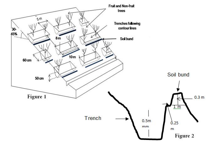
A detailed staggered contour trenches layout and its specifications (Fig. 1), and the cross section of soil bunds (Fig. 2)
Location: Bamyan. Bamyan center/Bamyan province
Technical knowledge required for land users: high
Technical knowledge required for SLM specialist: high
Main technical functions: control of dispersed runoff: retain / trap, increase of infiltration, sediment retention / trapping, sediment harvesting, increase of biomass (quantity), promotion of vegetation species and varieties (quality, eg palatable fodder)
Secondary technical functions: reduction of slope length, improvement of ground cover, increase in organic matter, increase / maintain water stored in soil, improvement of water quality, buffering / filtering water, spatial arrangement and diversification of land use
Retention/infiltration ditch/pit, sediment/sand trap
Spacing between structures (m): 8
Bund/ bank: level
Spacing between structures (m): 8
Height of bunds/banks/others (m): 0.5
ผู้เขียน:
Adapted from Bertran
4.2 ข้อมูลทั่วไปเกี่ยวกับการคำนวณปัจจัยนำเข้าและค่าใช้จ่าย
ให้ระบุว่าค่าใช้จ่ายและปัจจัยนำเข้าได้รับการคำนวณอย่างไร:
- ต่อพื้นที่ที่ใช้เทคโนโลยี
ระบุขนาดและหน่วยพื้นที่:
1 ha
ระบุสกุลเงินที่ใช้คำนวณค่าใช้จ่าย:
- USD
4.3 กิจกรรมเพื่อการจัดตั้ง
| กิจกรรม | Timing (season) | |
|---|---|---|
| 1. | Digging of the contour trenches and construction of the soil bunds | |
| 2. | Marking contour lines (A frame and lime) |
4.4 ค่าใช้จ่ายของปัจจัยนำเข้าที่จำเป็นสำหรับการจัดตั้ง
| ปัจจัยนำเข้า | หน่วย | ปริมาณ | ค่าใช้จ่ายต่อหน่วย | ค่าใช้จ่ายทั้งหมดต่อปัจจัยนำเข้า | %ของค่าใช้จ่ายที่ก่อให้เกิดขึ้นโดยผู้ใช้ที่ดิน | |
|---|---|---|---|---|---|---|
| แรงงาน | Digging of the contour trenches and construction of the soil bunds | persons/day/ha | 100.0 | 6.43 | 643.0 | |
| อุปกรณ์ | A frame and lime | ha | 1.0 | 1.8 | 1.8 | |
| ค่าใช้จ่ายทั้งหมดของการจัดตั้งเทคโนโลยี | 644.8 | |||||
| Total costs for establishment of the Technology in USD | 644.8 | |||||
แสดงความคิดเห็น:
Duration of establishment phase: 4 month(s)
4.5 การบำรุงรักษาสภาพหรือกิจกรรมที่เกิดขึ้นเป็นประจำ
| กิจกรรม | ช่วงระยะเวลา/ความถี่ | |
|---|---|---|
| 1. | No maintenance activities have been implemented for staggered contour trenches and soil bunds up to now. |
4.7 ปัจจัยสำคัญที่สุดที่มีผลกระทบต่อค่าใช้จ่าย
ปัจจัยสำคัญที่สุดที่มีผลกระทบต่อค่าใช้จ่ายต่างๆ:
Despite the application of the structural measure of the SCTs AKF is still continuing its financial support for the plantation of the area. Thus irrigation which is a costly activity is still continued by AKF's support. The planted saplings of fruit and non-fruit trees are irrigated for six months/year, i.e. from April to September. Water is carried to the site by tankers. Each month, 75 tankers are used and the cost of one tanker is 12 USD or 600 Afghani. In addition, 16 persons are employed for one time irrigation.
5. สิ่งแวดล้อมทางธรรมชาติและของมนุษย์
5.1 ภูมิอากาศ
ฝนประจำปี
- < 250 ม.ม.
- 251-500 ม.ม.
- 501-750 ม.ม.
- 751-1,000 ม.ม.
- 1,001-1,500 ม.ม.
- 1,501-2,000 ม.ม.
- 2,001-3,000 ม.ม.
- 3,001-4,000 ม.ม.
- > 4,000 ม.ม.
ข้อมูลจำเพาะ/ความคิดเห็นเรื่องปริมาณน้ำฝน:
Bamyan receives heavy snow falls and rain falls in winter season
เขตภูมิอากาศเกษตร
- กึ่งแห้งแล้ง
Thermal climate class: temperate
5.2 สภาพภูมิประเทศ
ค่าเฉลี่ยความลาดชัน:
- ราบเรียบ (0-2%)
- ลาดที่ไม่ชัน (3-5%)
- ปานกลาง (6-10%)
- เป็นลูกคลื่น (11-15%)
- เป็นเนิน (16-30%)
- ชัน (31-60%)
- ชันมาก (>60%)
ธรณีสัณฐาน:
- ที่ราบสูง/ที่ราบ
- สันเขา
- ไหล่เขา
- ไหล่เนินเขา
- ตีนเนิน
- หุบเขา
ระดับความสูง:
- 0-100 เมตร
- 101-500 เมตร
- 501-1,000 เมตร
- 1,001-1,500 เมตร
- 1,501-2,000 เมตร
- 2,001-2,500 เมตร
- 2,501-3,000 เมตร
- 3,001-4,000 เมตร
- > 4,000 เมตร
5.3 ดิน
ค่าเฉลี่ยความลึกของดิน:
- ตื้นมาก (0-20 ซ.ม.)
- ตื้น (21-50 ซ.ม.)
- ลึกปานกลาง (51-80 ซ.ม.)
- ลึก (81-120 ซ.ม.)
- ลึกมาก (>120 ซ.ม.)
เนื้อดิน (ดินชั้นบน):
- หยาบ/เบา (ดินทราย)
อินทรียวัตถุในดิน:
- ต่ำ (<1%)
(ถ้ามี) ให้แนบคำอธิบายเรื่องดินแบบเต็มหรือระบุข้อมูลที่มีอยู่ เช่น ชนิดของดิน ค่า pH ของดินหรือความเป็นกรดของดิน ความสามารถในการแลกเปลี่ยนประจุบวก ไนโตรเจน ความเค็ม เป็นต้น:
Soil fertility is very low - low
Soil drainage / infiltration is oor due to sealing
Soil water storage capacity is low
5.4 ความเป็นประโยชน์และคุณภาพของน้ำ
ระดับน้ำใต้ดิน:
> 50 เมตร
น้ำไหลบ่าที่ผิวดิน:
ไม่ดีหรือไม่มีเลย
คุณภาพน้ำ (ที่ยังไม่ได้บำบัด):
เป็นน้ำใช้เพื่อการเกษตรเท่านั้น (การชลประทาน)
5.5 ความหลากหลายทางชีวภาพ
ความหลากหลายทางชนิดพันธุ์:
- ต่ำ
5.6 ลักษณะของผู้ใช้ที่ดินที่นำเทคโนโลยีไปปฏิบัติใช้
แนวทางการตลาดของระบบการผลิต:
- เพื่อการยังชีพ (หาเลี้ยงตนเอง)
- mixed (subsistence/ commercial)
รายได้ที่มาจากนอกฟาร์ม:
- 10-50% ของรายได้ทั้งหมด
ระดับของความมั่งคั่งโดยเปรียบเทียบ:
- พอมีพอกิน
เป็นรายบุคคล/ครัวเรือน:
- ลูกจ้าง (บริษัท รัฐบาล)
ระบุลักษณะอื่นๆที่เกี่ยวข้องของผู้ใช้ที่ดิน:
Difference in the involvement of women and men: Mainly men were involved in the activities due to cultural reasons.
Population density: 10-50 persons/km2
Annual population growth: 3% - 4%
100% of the land users are average wealthy.
Off-farm income specification: This is more applicable for poor small landholders or landless families.
5.7 Average area of land used by land users applying the Technology
- < 0.5 เฮกตาร์
- 0.5-1 เฮกตาร์
- 1-2 เฮกตาร์
- 2-5 เฮกตาร์
- 5-15 เฮกตาร์
- 15-50 เฮกตาร์
- 50-100 เฮกตาร์
- 100-500 เฮกตาร์
- 500-1,000 เฮกตาร์
- 1,000-10,000 เฮกตาร์
- >10,000 เฮกตาร์
5.8 กรรมสิทธิ์ในที่ดิน สิทธิในการใช้ที่ดินและสิทธิในการใช้น้ำ
กรรมสิทธิ์ในที่ดิน:
- รัฐ
สิทธิในการใช้ที่ดิน:
- เข้าถึงได้แบบเปิด (ไม่ได้จัดระเบียบ)
สิทธิในการใช้น้ำ:
- เข้าถึงได้แบบเปิด (ไม่ได้จัดระเบียบ)
แสดงความคิดเห็น:
Formally, state owned. The site is now protected from open grazing and shrub cutting with support from the local communities.
5.9 การเข้าถึงบริการและโครงสร้างพื้นฐาน
การจ้างงาน (เช่น ภายนอกฟาร์ม):
- จน
- ปานกลาง
- ดี
ตลาด:
- จน
- ปานกลาง
- ดี
พลังงาน:
- จน
- ปานกลาง
- ดี
ถนนและการขนส่ง:
- จน
- ปานกลาง
- ดี
6. ผลกระทบและสรุปคำบอกกล่าว
6.1 ผลกระทบในพื้นที่ดำเนินการ (On-site) จากการใช้เทคโนโลยี
ผลกระทบทางด้านเศรษฐกิจและสังคม
การผลิต
การผลิตพืชที่ใช้เลี้ยงปศุสัตว์
คุณภาพพืชที่ใช้เลี้ยงปศุสัตว์
การผลิตสัตว์
การเสี่ยงต่อความล้มเหลวในการผลิต
ความหลากหลายของผลิตภัณฑ์
พื้นที่สำหรับการผลิต
แสดงความคิดเห็น/ระบุ:
Decreased production area
ความเป็นประโยชน์และคุณภาพของน้ำ
การมีน้ำไว้ให้ปศุสัตว์
รายได้และค่าใช้จ่าย
รายได้จากฟาร์ม
ผลกระทบด้านสังคมวัฒนธรรมอื่น ๆ
ความมั่นคงด้านอาหาร / พึ่งตนเองได้
สถานการณ์ด้านสุขภาพ
โอกาสทางวัฒนธรรม
แสดงความคิดเห็น/ระบุ:
As the site is greener now
โอกาสทางด้านสันทนาการ
สถาบันแห่งชาติ
แสดงความคิดเห็น/ระบุ:
Especially of DAIL (Department of Agriculture, Irrigation and Livestock) and the persons who visit the site
SLM หรือความรู้เรื่องความเสื่อมโทรมของที่ดิน
livelihood and human well-being
ผลกระทบด้านนิเวศวิทยา
วัฐจักรน้ำหรือน้ำบ่า
การเก็บเกี่ยวหรือการกักเก็บน้ำ
แสดงความคิดเห็น/ระบุ:
Runoff, dew, snow, etc.
น้ำไหลบ่าที่ผิวดิน
น้ำบาดาลหรือระดับน้ำในแอ่งน้ำบาดาล
ดิน
สิ่งปกคลุมดิน
ความหลากหลายทางชีวภาพของพืชและสัตว์
ความหลากหลายทางชีวภาพของพืช
ความหลากหลายทางชีวภาพของสัตว์
การจัดการศัตรูพืชและโรคพืช
ลดความเสี่ยงของภัยพิบัติ
ความเสี่ยงจากไฟ
6.2 ผลกระทบนอกพื้นที่ดำเนินการ (Off-site) จากการใช้เทคโนโลยี
น้ำท่วมพื้นที่ท้ายน้ำ
การทับถมของดินตะกอนพื้นที่ท้ายน้ำ
ตะกอนที่ถูกพัดพามาโดยลม
แสดงความคิดเห็น/ระบุ:
Due to better vegetation cover
6.3 การเผชิญและความตอบสนองของเทคโนโลยีต่อการเปลี่ยนแปลงสภาพภูมิอากาศที่ค่อยเป็นค่อยไป และสภาพรุนแรงของภูมิอากาศ / ภัยพิบัติ (ที่รับรู้ได้โดยผู้ใช้ที่ดิน)
การเปลี่ยนแปลงสภาพภูมิอากาศที่ค่อยเป็นค่อยไป
การเปลี่ยนแปลงสภาพภูมิอากาศที่ค่อยเป็นค่อยไป
| ฤดู | increase or decrease | เทคโนโลยีมีวิธีการรับมืออย่างไร | |
|---|---|---|---|
| อุณหภูมิประจำปี | เพิ่มขึ้น | ดี |
สภาพรุนแรงของภูมิอากาศ (ภัยพิบัติ)
ภัยพิบัติทางอุตุนิยมวิทยา
| เทคโนโลยีมีวิธีการรับมืออย่างไร | |
|---|---|
| พายุลมประจำท้องถิ่น | ดี |
ภัยพิบัติจากสภาพภูมิอากาศ
| เทคโนโลยีมีวิธีการรับมืออย่างไร | |
|---|---|
| ภัยจากฝนแล้ง | ดี |
ภัยพิบัติจากน้ำ
| เทคโนโลยีมีวิธีการรับมืออย่างไร | |
|---|---|
| น้ำท่วมตามปกติ (แม่น้ำ) | ไม่ค่อยดี |
ผลลัพธ์ตามมาที่เกี่ยวข้องกับภูมิอากาศอื่น ๆ
ผลลัพธ์ตามมาที่เกี่ยวข้องกับภูมิอากาศอื่น ๆ
| เทคโนโลยีมีวิธีการรับมืออย่างไร | |
|---|---|
| ช่วงการปลูกพืชที่ลดลงมา | ดี |
แสดงความคิดเห็น:
SCT must be combined with vegetation and management measures
6.4 การวิเคราะห์ค่าใช้จ่ายและผลประโยชน์ที่ได้รับ
ผลประโยชน์ที่ได้รับเปรียบเทียบกับค่าใช้จ่ายในการจัดตั้งเป็นอย่างไร (จากมุมมองของผู้ใช้ที่ดิน)
ผลตอบแทนระยะสั้น:
ด้านบวกเล็กน้อย
ผลตอบแทนระยะยาว:
ด้านบวกอย่างมาก
ผลประโยชน์ที่ได้รับเปรียบเทียบกับค่าใช้จ่ายในการบำรุงรักษาหรือต้นทุนที่เกิดขึ้นซ้ำอีก เป็นอย่างไร (จากมุมมองของผู้ใช้ที่ดิน)
ผลตอบแทนระยะสั้น:
ด้านบวก
ผลตอบแทนระยะยาว:
ด้านบวกอย่างมาก
แสดงความคิดเห็น:
The benefits stated are the combined impacts of all measures-structural, vegetative and management. SCTs have helped in the establishment of vegetative measures by contributing to increased soil moisture, reduced runoff and soil loss.
6.5 การปรับตัวของเทคโนโลยี
Of all those who have adopted the Technology, how many did so spontaneously, i.e. without receiving any material incentives/ payments?
- 0-10%
แสดงความคิดเห็น:
Comments on acceptance with external material support: The whole project activities were implemented by external supports
There is no trend towards spontaneous adoption of the Technology
Comments on adoption trend: As the implementation of a watershed project requires high costs and investments which can not be affordable for the individual land users.
6.7 จุดแข็ง / ข้อได้เปรียบ / โอกาสของเทคโนโลยี
| จุดแข็ง / ข้อได้เปรียบ / โอกาสในทัศนคติของผู้ใช้ที่ดิน |
|---|
| The land users views were not considered. |
| จุดแข็ง / ข้อได้เปรียบ / โอกาสในทัศนคติของผู้รวบรวมหรือวิทยากรหลัก |
|---|
|
Helps in reducing flash flood risks due to less runoff How can they be sustained / enhanced? Proper institutional mechanisms, involving the government, non-government and community institutions should be developed for sustaining project activities. Department of Agriculture, Irrigation and Livestock DAIL; (Bamyan) should take lead |
|
Conserves soil and enhances soil cover and fertility leading to more on-site production How can they be sustained / enhanced? Vegetative measures should be strengthened |
| Complements re-greening efforts by reducing erosion and conserving moisture |
| The quality of contour trenches and soil bunds are very good and maintenance costs negligible |
| The site is used for demonstration, training and exposure visits |
6.8 จุดอ่อน / ข้อเสียเปรียบ / ความเสี่ยงของเทคโนโลยีและวิธีการแก้ไข
| จุดอ่อน / ข้อเสียเปรียบ / ความเสี่ยงในทัศนคติของผู้รวบรวมหรือวิทยากรหลัก | มีวิธีการแก้ไขได้อย่างไร |
|---|---|
| Establishment costs are very high | Voluntary community contributions, if they have an active stake in the project, would reduce the costs, otherwise, there has to be external support at least for the establishment phase |
| Loss of land for production | Planting suitable plants inside the trenches and along soil bunds |
| Requires high level of technical knowledge for establishment | Practical training for the target groups |
7. การอ้างอิงและการเชื่อมต่อ
7.1 วิธีการและแหล่งข้อมูล
ลิงก์และโมดูล
ขยายทั้งหมด ย่อทั้งหมดลิงก์
Community-based Natural Resource Management [อัฟกานิสถาน]
An approach to community participation in the sustainable management of natural resources
- ผู้รวบรวม: Aqila Haidery
โมดูล
ไม่มีโมดูล