Grass strips [ไนเจอร์]
- ผู้สร้างสรรค์:
- การอัพเดท:
- ผู้รวบรวม: Dieter Nill
- ผู้เรียบเรียง: –
- ผู้ตรวจสอบ: Deborah Niggli, Alexandra Gavilano
Bandes enherbées (French)
technologies_1621 - ไนเจอร์
ดูส่วนย่อย
ขยายทั้งหมด ย่อทั้งหมด1. ข้อมูลทั่วไป
1.2 รายละเอียดที่ติดต่อได้ของผู้รวบรวมและองค์กรที่เกี่ยวข้องในการประเมินและการจัดเตรียมทำเอกสารของเทคโนโลยี
ผู้เชี่ยวชาญ SLM:
Mamadou Abdou Gaoh Sani
Programme d’Appui à l’agriculture Productive (PROMAP), Niamey, Niger
ไนเจอร์
ชื่อของโครงการซึ่งอำนวยความสะดวกในการทำเอกสารหรือการประเมินเทคโนโลยี (ถ้าเกี่ยวข้อง)
Good Practices in Soil and Water Conservation - A contribution to adaptation and farmers ́ resilience towards climate change in the Sahel (GIZ)ชื่อขององค์กรซึ่งอำนวยความสะดวกในการทำเอกสารหรือการประเมินเทคโนโลยี (ถ้าเกี่ยวข้อง)
Deutsche Gesellschaft für Internationale Zusammenarbeit (GIZ) - เยอรมนี1.3 เงื่อนไขการใช้ข้อมูลที่ได้บันทึกผ่านทาง WOCAT
ผู้รวบรวมและวิทยากรหลักยอมรับเงื่อนไขเกี่ยวกับการใช้ข้อมูลที่ถูกบันทึกผ่านทาง WOCAT:
ใช่
1.4 การเปิดเผยเรื่องความยั่งยืนของเทคโนโลยีที่ได้อธิบายไว้
เทคโนโลยีที่ได้อธิบายไว้นี้เป็นปัญหาของความเสื่อมโทรมโทรมของที่ดินหรือไม่ จึงไม่ได้รับการยอมรับว่าเป็นเทคโนโลยีเพื่อการจัดการที่ดินอย่างยั่งยืน:
ไม่ใช่
2. การอธิบายลักษณะของเทคโนโลยี SLM
2.1 การอธิบายแบบสั้น ๆ ของเทคโนโลยี
คำจำกัดความของเทคโนโลยี:
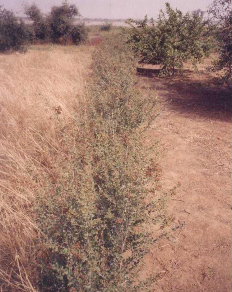
Grass strips slow down runoff, increase infiltration and retain sediment, thus increasing crop production.
2.2 การอธิบายแบบละเอียดของเทคโนโลยี
คำอธิบาย:
Grass strips measuring 0.80 m to 1 m wide are planted 20 to 80 m apart on low-gradient terrain. Local grasses (for example, Andropogon gayanus, Cymbopogon schoenateus and Vetivera nigritiana) are sown or planted (plantlets) at the start of the rainy season. Like stone bunds, grass strips are planted along the natural contour of the land to slow down runoff, increase infiltration and retain sediment. Grass strips get bigger as sediment builds up, which maintains their capacity to retain water, unlike mechanical structures (stone bunds and dikes).
The species of grass are chosen according to what the farmers want to use them for (straw, hay, mat weaving, roofing, construction of straw granaries, brooms, etc.). In cattle and sheep raising areas, the use of fodder plants can increase interest in this technique and ensure wider acceptance. It is recommended that the development of grass strips be combined with assisted natural regeneration (woody species) or the planting of trees.
Designed as an erosion control measure, grass strips slow down runoff in the event of heavy rain. They distribute rainwater more evenly over the land and improve infiltration which is particularly important when there are dry spells in the rainy season. Sediment builds up behind the grass strips, thereby reducing the erosion of fertile soil layers. The roots of the plants bind the soil and hold it in place. Although the vegetation growing in the strips competes with the crops to some extent for water, the overall effect on yields is positive. Crops are also protected from wind erosion. Thanks to the vegetation cover they provide, grass strips contribute to lowering soil temperature.
Like contour stone bunds, grass strips reduce the harmful effects of heavy rain and violent downpours, events that are expected to increase as a result of climate change.
Compared with plots without grass strips, millet yields were 50 kg per hectare per year higher, and straw yields 125 kg higher on plots with grass strips. Yields can be substantially improved by combining grass strips with the application of organic fertiliser, mulch or pen manure. The best results, an average increase of 280 kg of millet grain per hectare (370 kg of straw per hectare), were achieved by combining them with mulching and pen manuring. Grass strips therefore improve yields of cereals and forage for livestock (straw and grass growing on the strips).
Increased crop output increases household food security and improves livestock feeding. The straw cut on the grass strips can also be used for other purposes (fencing and roofing). It is also a source of income, as traditional products made with straw, such as woven mats, can be sold.
Grass growth tends to be patchy, and resowing is required several times to fill in the gaps in the strip. In order to protect the grass strips from grazing animals during the first year, it is recommended that the area be monitored, which requires strict control over the village herds and flocks and those of nomadic livestock keepers.
Some grasses tend to invade crop fields. It is therefore important to control them by cutting them down before they flower and to tend the strips regularly, straightening and cutting back the edges.
Any dead plants in the grass strips must be regularly replaced. Grass strips are more likely to be maintained if they are economically profitable, for example, if they produce hay for livestock or their output can be sold as forage or construction material.
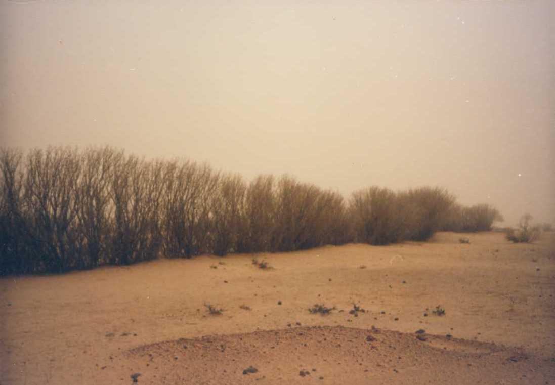
It is a technique designed mainly for cropland, but can also be used on rangeland, provided that the plants are protected when the grass strips are put in place. Grass strips are suitable for areas in the Sahel and the Sudan with rainfall ranging between 400 and 1,000 mm/year and gently sloping terrain (< 2%). Ecological units that benefit from the implementation of this measure include dune land, pediments and plains (highland pediments). Grass strips are particularly appropriate for non-stony land in areas with higher rainfall levels.
2.3 รูปภาพของเทคโนโลยี
อัลบั้มสื่อบันทึก
2.5 ประเทศภูมิภาค หรือสถานที่ตั้งที่เทคโนโลยีได้นำไปใช้และได้รับการครอบคลุมโดยการประเมินนี้
ประเทศ:
ไนเจอร์
ภูมิภาค/รัฐ/จังหวัด:
Niger
ข้อมูลจำเพาะเพิ่มเติมของสถานที่ตั้ง :
Filingué, Ouallam, Tillabéri, Tera
ระบุการกระจายตัวของเทคโนโลยี:
- กระจายไปอย่างสม่ำเสมอในพื้นที่
If precise area is not known, indicate approximate area covered:
- 10-100 ตร.กม.
แสดงความคิดเห็น:
After three seasons of promoting this technique, grass strips had been established on a total area of 4674 hectares (sometimes in combination with other measures). Over half of the improved land is located in the Filingué area (2587 hectares), followed by Ouallam with 1042 hectares. However, only small areas were improved with grass strips in Tillabéri and Tera (228 hectares and 817 hectares respectively), where acceptance of this technique was low
Map
×2.6 วันที่การดำเนินการ
ถ้าไม่รู้ปีที่แน่นอน ให้ระบุวันที่โดยประมาณ:
- 10-50 ปี
2.7 คำแนะนำของเทคโนโลยี
ให้ระบุว่าเทคโนโลยีถูกแนะนำเข้ามาอย่างไร:
- ทางโครงการหรือจากภายนอก
ความคิดเห็น (ประเภทของโครงการ เป็นต้น) :
developed, implemented and disseminated as part of projects and programmes undertaken from the 1980s onwards to combat desertification and improve natural resource management. Implemented by GIZ (German Federal Enterprise for International Cooperation), PDRT (Projet de développement rural de Tahoua - Tahoua Rural Development Project), PASP (Projet de protection intégrée des ressources agro-sylvo-pastorales Tillabéri-Nord - Project for the Integrated Protection of Agricultural, Forest and Rangeland Resources in Tillabéri-Nord), and PATECORE (project for land development and resource conservation in Plateau Central Burkina Faso)
3. การจัดประเภทของเทคโนโลยี SLM
3.1 วัตถุประสงค์หลักของเทคโนโลยี
- ลด ป้องกัน ฟื้นฟู การเสื่อมโทรมของที่ดิน
3.2 ประเภทของการใช้ที่ดินในปัจจุบันที่ได้นำเทคโนโลยีไปใช้

พื้นที่ปลูกพืช
- การปลูกพืชล้มลุกอายุปีเดียว
จำนวนของฤดูเพาะปลูกต่อปี:
- 1
ระบุ:
Longest growing period in days: 120, Longest growing period from month to month: August to October

ทุ่งหญ้าเลี้ยงสัตว์
Extensive grazing:
- กึ่งโนแมนดิซึ่มหรือแพสโตแรลลิซึ่ม (Semi-nomadism/pastoralism)
ทุ่งหญ้าเลี้ยงสัตว์ที่มีการจัดการแบบเข้มข้นหรือการผลิตอาหารสัตว์:
- ตัดแล้วขนไป / ไม่มีการปล่อยแทะเล็มเอง (Cut-and-carry / zero grazing)
แสดงความคิดเห็น:
Major land use problems (compiler’s opinion): soil erosion by water and wind, fertility decline
Livestock density: 1-10 LU /km2
3.4 การใช้น้ำ
การใช้น้ำของที่ดินที่มีการใช้เทคโนโลยีอยู่:
- จากน้ำฝน
3.5 กลุ่ม SLM ที่ตรงกับเทคโนโลยีนี้
- การจัดการปศุสัตว์และทุ่งหญ้าเลี้ยงสัตว์
- มาตรการปลูกพืชขวางความลาดชัน (cross-slope measure)
3.6 มาตรการ SLM ที่ประกอบกันเป็นเทคโนโลยี

มาตรการอนุรักษ์ด้วยวิธีพืช
- V1: ต้นไม้และพุ่มไม้คลุมดิน
- V2: หญ้าและไม้ยืนต้น
แสดงความคิดเห็น:
Type of vegetative measures: aligned: -contour
3.7 รูปแบบหลักของการเสื่อมโทรมของที่ดินที่ได้รับการแก้ไขโดยเทคโนโลยี

การกัดกร่อนของดินโดยน้ำ
- Wt (Loss of topsoil): การสูญเสียดินชั้นบนหรือการกัดกร่อนที่ผิวดิน

การกัดกร่อนของดินโดยลม
- Et (Loss of topsoil): การสูญเสียดินชั้นบน

การเสื่อมโทรมของดินทางด้านเคมี
- Cn (Fertility decline): ความอุดมสมบูรณ์และปริมาณอินทรียวัตถุในดินถูกทำให้ลดลงไป (ไม่ได้เกิดจากสาเหตุการกัดกร่อน)

การเสื่อมโทรมของน้ำ
- Ha (Aridification): การเกิดความแห้งแล้ง
แสดงความคิดเห็น:
Main causes of degradation: soil management (Unadapted landuse methods, reduced or abandoned fallow periods), crop management (annual, perennial, tree/shrub) (Neglect of fallow periods and crop rotation), droughts (due to heat waves), population pressure (rapidly growing population increasing pressure on land), land tenure (insecure access to land and collectively managed communal land), poverty / wealth (very poor population)
Secondary causes of degradation: deforestation / removal of natural vegetation (incl. forest fires) (deforestation through overgrazing and fire wood collection), over-exploitation of vegetation for domestic use (firewood collection), overgrazing (cattle, sheep and goats), change in temperature (Climate change: heat waves), change of seasonal rainfall (more variable onset of rain), Heavy / extreme rainfall (intensity/amounts) (more variable and intensive rains), wind storms / dust storms (frequent storms), floods (due to intensive rain storms), labour availability (some migration of men to nearby cities), education, access to knowledge and support services (high level of illiteracy)
3.8 การป้องกัน การลดลง หรือการฟื้นฟูความเสื่อมโทรมของที่ดิน
ระบุเป้าหมายของเทคโนโลยีกับความเสื่อมโทรมของที่ดิน:
- ป้องกันความเสื่อมโทรมของที่ดิน
- ลดความเสื่อมโทรมของดิน
4. ข้อมูลจำเพาะด้านเทคนิค กิจกรรมการนำไปปฏิบัติใช้ ปัจจัยนำเข้า และค่าใช้จ่าย
4.1 แบบแปลนทางเทคนิคของเทคโนโลยี
ข้อมูลจำเพาะด้านเทคนิค (แบบแปลนทางเทคนิคของเทคโนโลยี):
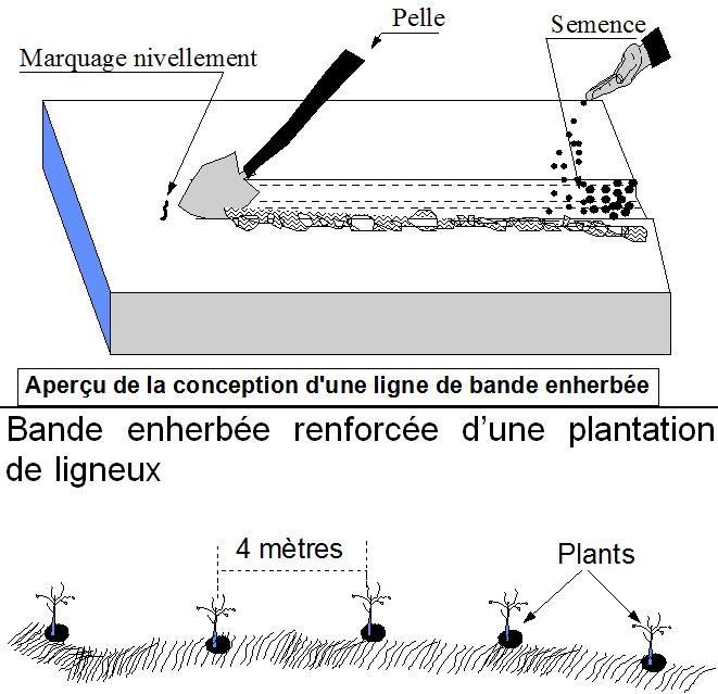
Grass strips measuring 0.80 m to 1 m wide are planted 20 to 80 m apart on low-gradient terrain. Local grasses (for example, Andropogon gayanus, Cymbopogon schoenateus and Vetivera nigritiana) are sown or planted (plantlets) along the natural contour at the start of the rainy season.
Technical knowledge required for field staff / advisors: moderate
Technical knowledge required for land users: low
Main technical functions: control of dispersed runoff: retain / trap, control of dispersed runoff: impede / retard, control of concentrated runoff: retain / trap, control of concentrated runoff: impede / retard, improvement of ground cover, stabilisation of soil (eg by tree roots against land slides), increase in organic matter, increase in nutrient availability (supply, recycling,…), increase of infiltration, increase / maintain water stored in soil, water harvesting / increase water supply, sediment retention / trapping, sediment harvesting, reduction in wind speed, increase of biomass (quantity), promotion of vegetation species and varieties (quality, eg palatable fodder)
Secondary technical functions: increase of groundwater level / recharge of groundwater
Aligned: -contour
Vegetative material: T : trees / shrubs, G : grass
Number of plants per (ha): 200
Spacing between rows / strips / blocks (m): 20-80
Width within rows / strips / blocks (m): 0.8-1
Grass species: Andropogon gayanus, Cymbopogon schoenateus and Vetivera nigritiana
ผู้เขียน:
PASP
4.2 ข้อมูลทั่วไปเกี่ยวกับการคำนวณปัจจัยนำเข้าและค่าใช้จ่าย
อื่นๆ หรือสกุลเงินประจำชาติ (ระบุ):
CFA Franc
4.3 กิจกรรมเพื่อการจัดตั้ง
| กิจกรรม | Timing (season) | |
|---|---|---|
| 1. | marking out the contour lines | |
| 2. | making 10-15 cm deep furrows in which to plant the seeds or seedlings | |
| 3. | sowing or planting 1 to 4 rows per strip. |
4.4 ค่าใช้จ่ายของปัจจัยนำเข้าที่จำเป็นสำหรับการจัดตั้ง
| ปัจจัยนำเข้า | หน่วย | ปริมาณ | ค่าใช้จ่ายต่อหน่วย | ค่าใช้จ่ายทั้งหมดต่อปัจจัยนำเข้า | %ของค่าใช้จ่ายที่ก่อให้เกิดขึ้นโดยผู้ใช้ที่ดิน | |
|---|---|---|---|---|---|---|
| แรงงาน | labour | ha | 1.0 | 46.7 | 46.7 | 100.0 |
| วัสดุด้านพืช | seeds | ha | 1.0 | 3.3 | 3.3 | 100.0 |
| ค่าใช้จ่ายทั้งหมดของการจัดตั้งเทคโนโลยี | 50.0 | |||||
| Total costs for establishment of the Technology in USD | 50.0 | |||||
4.5 การบำรุงรักษาสภาพหรือกิจกรรมที่เกิดขึ้นเป็นประจำ
| กิจกรรม | ช่วงระยะเวลา/ความถี่ | |
|---|---|---|
| 1. | resowing is required several times. Any dead plants in the grass strips must be regularly replaced. | |
| 2. | Cutting down grasses which invade crop fields. | |
| 3. | straightening and cutting back the edges |
4.7 ปัจจัยสำคัญที่สุดที่มีผลกระทบต่อค่าใช้จ่าย
ปัจจัยสำคัญที่สุดที่มีผลกระทบต่อค่าใช้จ่ายต่างๆ:
Labour: 6 man-days per ha
• marking out the contour lines
• making 10-15 cm deep furrows in which to plant the seeds or seedlings
• sowing or planting 1 to 4 rows per strip. Upkeep: 2.5 man-days per year.
Other costs:
• grass seeds or seedlings
• equipment: water-tube level.
5. สิ่งแวดล้อมทางธรรมชาติและของมนุษย์
5.1 ภูมิอากาศ
ฝนประจำปี
- < 250 ม.ม.
- 251-500 ม.ม.
- 501-750 ม.ม.
- 751-1,000 ม.ม.
- 1,001-1,500 ม.ม.
- 1,501-2,000 ม.ม.
- 2,001-3,000 ม.ม.
- 3,001-4,000 ม.ม.
- > 4,000 ม.ม.
เขตภูมิอากาศเกษตร
- กึ่งแห้งแล้ง
Thermal climate class: subtropics
5.2 สภาพภูมิประเทศ
ค่าเฉลี่ยความลาดชัน:
- ราบเรียบ (0-2%)
- ลาดที่ไม่ชัน (3-5%)
- ปานกลาง (6-10%)
- เป็นลูกคลื่น (11-15%)
- เป็นเนิน (16-30%)
- ชัน (31-60%)
- ชันมาก (>60%)
ธรณีสัณฐาน:
- ที่ราบสูง/ที่ราบ
- สันเขา
- ไหล่เขา
- ไหล่เนินเขา
- ตีนเนิน
- หุบเขา
ระดับความสูง:
- 0-100 เมตร
- 101-500 เมตร
- 501-1,000 เมตร
- 1,001-1,500 เมตร
- 1,501-2,000 เมตร
- 2,001-2,500 เมตร
- 2,501-3,000 เมตร
- 3,001-4,000 เมตร
- > 4,000 เมตร
5.3 ดิน
ค่าเฉลี่ยความลึกของดิน:
- ตื้นมาก (0-20 ซ.ม.)
- ตื้น (21-50 ซ.ม.)
- ลึกปานกลาง (51-80 ซ.ม.)
- ลึก (81-120 ซ.ม.)
- ลึกมาก (>120 ซ.ม.)
เนื้อดิน (ดินชั้นบน):
- ปานกลาง (ดินร่วน ทรายแป้ง)
- ละเอียด/หนัก (ดินเหนียว)
อินทรียวัตถุในดิน:
- ต่ำ (<1%)
5.4 ความเป็นประโยชน์และคุณภาพของน้ำ
ระดับน้ำใต้ดิน:
5-50 เมตร
น้ำไหลบ่าที่ผิวดิน:
ปานกลาง
คุณภาพน้ำ (ที่ยังไม่ได้บำบัด):
เป็นน้ำใช้เพื่อการเกษตรเท่านั้น (การชลประทาน)
5.5 ความหลากหลายทางชีวภาพ
ความหลากหลายทางชนิดพันธุ์:
- ต่ำ
5.6 ลักษณะของผู้ใช้ที่ดินที่นำเทคโนโลยีไปปฏิบัติใช้
แนวทางการตลาดของระบบการผลิต:
- เพื่อการยังชีพ (หาเลี้ยงตนเอง)
รายได้ที่มาจากนอกฟาร์ม:
- 10-50% ของรายได้ทั้งหมด
ระดับของความมั่งคั่งโดยเปรียบเทียบ:
- ยากจนมาก
- จน
ระดับของการใช้เครื่องจักรกล:
- งานที่ใช้แรงกาย
- การใช้กำลังจากสัตว์
เพศ:
- ชาย
ระบุลักษณะอื่นๆที่เกี่ยวข้องของผู้ใช้ที่ดิน:
Population density: 10-50 persons/km2
Annual population growth: 3% - 4% (mostly poor households below poverty line).
Off-farm income specification: men migrate temporarily or permanently to cities for off-farm income, women and men seasonally carry out paid farm work
5.7 Average area of land used by land users applying the Technology
- < 0.5 เฮกตาร์
- 0.5-1 เฮกตาร์
- 1-2 เฮกตาร์
- 2-5 เฮกตาร์
- 5-15 เฮกตาร์
- 15-50 เฮกตาร์
- 50-100 เฮกตาร์
- 100-500 เฮกตาร์
- 500-1,000 เฮกตาร์
- 1,000-10,000 เฮกตาร์
- >10,000 เฮกตาร์
พิจารณาว่าเป็นขนาดเล็ก กลาง หรือขนาดใหญ่ (ซึ่งอ้างอิงถึงบริบทระดับท้องถิ่น):
- ขนาดเล็ก
5.8 กรรมสิทธิ์ในที่ดิน สิทธิในการใช้ที่ดินและสิทธิในการใช้น้ำ
กรรมสิทธิ์ในที่ดิน:
- รัฐ
- รายบุคคล ไม่ได้รับสิทธิครอบครอง
สิทธิในการใช้ที่ดิน:
- เข้าถึงได้แบบเปิด (ไม่ได้จัดระเบียบ)
สิทธิในการใช้น้ำ:
- เข้าถึงได้แบบเปิด (ไม่ได้จัดระเบียบ)
แสดงความคิดเห็น:
traditional land use rights prevail. On fields individual land use rights, communal rights on pasture and forest land (collection of wood and other products (fruits, medicinal plants))
5.9 การเข้าถึงบริการและโครงสร้างพื้นฐาน
สุขภาพ:
- จน
- ปานกลาง
- ดี
การศึกษา:
- จน
- ปานกลาง
- ดี
ความช่วยเหลือทางด้านเทคนิค:
- จน
- ปานกลาง
- ดี
การจ้างงาน (เช่น ภายนอกฟาร์ม):
- จน
- ปานกลาง
- ดี
ตลาด:
- จน
- ปานกลาง
- ดี
พลังงาน:
- จน
- ปานกลาง
- ดี
ถนนและการขนส่ง:
- จน
- ปานกลาง
- ดี
น้ำดื่มและการสุขาภิบาล:
- จน
- ปานกลาง
- ดี
บริการด้านการเงิน:
- จน
- ปานกลาง
- ดี
6. ผลกระทบและสรุปคำบอกกล่าว
6.1 ผลกระทบในพื้นที่ดำเนินการ (On-site) จากการใช้เทคโนโลยี
ผลกระทบทางด้านเศรษฐกิจและสังคม
การผลิต
การผลิตพืชผล
การผลิตพืชที่ใช้เลี้ยงปศุสัตว์
การผลิตสัตว์
การเสี่ยงต่อความล้มเหลวในการผลิต
พื้นที่สำหรับการผลิต
แสดงความคิดเห็น/ระบุ:
Part of the plot is taken up by the grass strips, reducing the area left for growing crops
รายได้และค่าใช้จ่าย
รายได้จากฟาร์ม
ความหลากหลายของแหล่งผลิตรายได้
ภาระงาน
ผลกระทบทางด้านเศรษฐกิจและสังคมอื่น ๆ
competition of grasses with crops
ผลกระทบด้านสังคมวัฒนธรรมอื่น ๆ
ความมั่นคงด้านอาหาร / พึ่งตนเองได้
การบรรเทาความขัดแย้ง
contribution to human well-being
แสดงความคิดเห็น/ระบุ:
Increased crop output increases household food security and improves livestock feeding. The straw cut on the grass strips can also be used for other purposes (fencing and roofing). It is also a source of income, as traditional products made with straw, such as woven mats, can be sold.
ผลกระทบด้านนิเวศวิทยา
วัฐจักรน้ำหรือน้ำบ่า
การเก็บเกี่ยวหรือการกักเก็บน้ำ
น้ำไหลบ่าที่ผิวดิน
ดิน
ความชื้นในดิน
สิ่งปกคลุมดิน
การสูญเสียดิน
การหมุนเวียนและการเติมของธาตุอาหาร
ลดความเสี่ยงของภัยพิบัติ
ความเร็วของลม
6.2 ผลกระทบนอกพื้นที่ดำเนินการ (Off-site) จากการใช้เทคโนโลยี
น้ำท่วมพื้นที่ท้ายน้ำ
การทับถมของดินตะกอนพื้นที่ท้ายน้ำ
ตะกอนที่ถูกพัดพามาโดยลม
6.3 การเผชิญและความตอบสนองของเทคโนโลยีต่อการเปลี่ยนแปลงสภาพภูมิอากาศที่ค่อยเป็นค่อยไป และสภาพรุนแรงของภูมิอากาศ / ภัยพิบัติ (ที่รับรู้ได้โดยผู้ใช้ที่ดิน)
การเปลี่ยนแปลงสภาพภูมิอากาศที่ค่อยเป็นค่อยไป
การเปลี่ยนแปลงสภาพภูมิอากาศที่ค่อยเป็นค่อยไป
| ฤดู | increase or decrease | เทคโนโลยีมีวิธีการรับมืออย่างไร | |
|---|---|---|---|
| อุณหภูมิประจำปี | เพิ่มขึ้น | ดี |
สภาพรุนแรงของภูมิอากาศ (ภัยพิบัติ)
ภัยพิบัติทางอุตุนิยมวิทยา
| เทคโนโลยีมีวิธีการรับมืออย่างไร | |
|---|---|
| พายุฝนประจำท้องถิ่น | ดี |
| พายุลมประจำท้องถิ่น | ดี |
ภัยพิบัติจากสภาพภูมิอากาศ
| เทคโนโลยีมีวิธีการรับมืออย่างไร | |
|---|---|
| ภัยจากฝนแล้ง | ไม่ค่อยดี |
ภัยพิบัติจากน้ำ
| เทคโนโลยีมีวิธีการรับมืออย่างไร | |
|---|---|
| น้ำท่วมตามปกติ (แม่น้ำ) | ดี |
ผลลัพธ์ตามมาที่เกี่ยวข้องกับภูมิอากาศอื่น ๆ
ผลลัพธ์ตามมาที่เกี่ยวข้องกับภูมิอากาศอื่น ๆ
| เทคโนโลยีมีวิธีการรับมืออย่างไร | |
|---|---|
| ช่วงการปลูกพืชที่ลดลงมา | ไม่ทราบ |
6.4 การวิเคราะห์ค่าใช้จ่ายและผลประโยชน์ที่ได้รับ
ผลประโยชน์ที่ได้รับเปรียบเทียบกับค่าใช้จ่ายในการจัดตั้งเป็นอย่างไร (จากมุมมองของผู้ใช้ที่ดิน)
ผลตอบแทนระยะสั้น:
ด้านบวกเล็กน้อย
ผลตอบแทนระยะยาว:
ด้านบวกเล็กน้อย
ผลประโยชน์ที่ได้รับเปรียบเทียบกับค่าใช้จ่ายในการบำรุงรักษาหรือต้นทุนที่เกิดขึ้นซ้ำอีก เป็นอย่างไร (จากมุมมองของผู้ใช้ที่ดิน)
ผลตอบแทนระยะสั้น:
ด้านบวกเล็กน้อย
ผลตอบแทนระยะยาว:
ด้านบวกเล็กน้อย
6.5 การปรับตัวของเทคโนโลยี
แสดงความคิดเห็น:
In the Tillabéri area, in northern Niger, the adoption of grass strips varies greatly from one place to another. After three seasons of promoting this technique, grass strips had been established on a total area of 4,674 hectares (sometimes in combination with other measures). Over half of the improved land is located in the Filingué area (2,587 hectares), followed by Ouallam with 1,042 hectares.
However, only small areas were improved with grass strips in Tillabéri and Tera (228 hectares and 817 hectares respectively), where acceptance of this technique was low.
In spite of good results in terms of increased production and soil improvement, grass strips have only been widely accepted in southern Niger (Maradi and Zinder). Farmers are of the view that grass strips could be confused with plot boundaries.
The availability of land in southern Niger may be another factor that facilitates acceptance of the measure is this area. Part of the plot is taken up by the grass strips, reducing the area left for growing crops. This hinders acceptance in areas where land is limited. The reduced crop-growing area is offset by better per-hectare grain, straw and hay yields. Certain grasses (such as Andropogon gayanus) have a harmful effect on nearby crops. The systematic exploitation of the grass strips as a source of straw or hay improves acceptance of the technique. In the Tillabéri area, in Niger, the adoption of grass strips varies greatly from one place to another. After three seasons of promoting this technique, grass strips had been established on a total area of 4,674 hectares (sometimes in combination with other measures). Over half of the improved land is located in the Filingué area (2,587 hectares), followed by Ouallam with 1,042 hectares. However, only small areas were improved with grass strips in Tillabéri and Tera (228 hectares and 817 hectares respectively), where acceptance of this technique was low. In spite of good results in terms of increased production and soil improvement, grass strips have only been widely accepted in southern Niger (Maradi and Zinder). Farmers are of the view that grass strips could be confused with plot boundaries. The availability of land in southern Niger may be another factor that facilitates acceptance of the measure is this area. Part of the plot is taken up by the grass strips, reducing the area left for growing crops. This hinders acceptance in areas where land is limited. The reduced crop-growing area is offset by better per-hectare grain, straw and hay yields. Certain grasses (such as Andropogon gayanus) have a harmful effect on nearby crops. The systematic exploitation of the grass strips as a source of straw or hay improves acceptance of the technique. At first, people living in the areas covered by the PDRT project were reluctant to establish grass strips. They considered them to be weeds with no place on their farmland. With time and exchange visits within the country, they began to accept the technique.
6.7 จุดแข็ง / ข้อได้เปรียบ / โอกาสของเทคโนโลยี
| จุดแข็ง / ข้อได้เปรียบ / โอกาสในทัศนคติของผู้รวบรวมหรือวิทยากรหลัก |
|---|
| reduce the harmful effects of heavy rain and violent downpours, events that are expected to increase as a result of climate change |
| improve rainwater harvesting and water retention in the soil |
| contribute to creating vegetation cover, which provides a habitat for biodiversity |
| contribute to lowering soil temperature and are also effective in reducing wind erosion. As the vegetation provides shelter from the wind, fine particles of soil accumulate behind the strips. |
| Increased crop output increases household food security and improves livestock feeding. The straw cut on the grass strips can also be used for other purposes (fencing and roofing). It is also a source of income, as traditional products made with straw, such as woven mats, can be sold. |
6.8 จุดอ่อน / ข้อเสียเปรียบ / ความเสี่ยงของเทคโนโลยีและวิธีการแก้ไข
| จุดอ่อน / ข้อเสียเปรียบ / ความเสี่ยงในทัศนคติของผู้รวบรวมหรือวิทยากรหลัก | มีวิธีการแก้ไขได้อย่างไร |
|---|---|
| Grass growth tends to be patchy, and resowing is required several times to fill in the gaps in the strip. Strips with bare patches are not effective in retaining water, and rilling can be caused by water gushing through the gaps. | The clumps must therefore be arranged in staggered rows and the strips made wide enough to prevent this problem. |
| With the use of certain types of grasses that grow in clumps, such as Andropogon grass, gaps are left between the tufts, and water spurting through these gaps can cause rilling. | |
| In spite of good results in terms of increased production and soil improvement, grass strips have only been widely accepted in southern Niger (Maradi and Zinder). Farmers are of the view that grass strips could be confused with plot boundaries. | |
| Certain grasses (such as Andropogon gayanus) have a harmful effect on nearby crops. | |
| Part of the plot is taken up by the grass strips, reducing the area left for growing crops. This hinders acceptance in areas where land is limited. |
7. การอ้างอิงและการเชื่อมต่อ
7.1 วิธีการและแหล่งข้อมูล
- ไปเยี่ยมชมภาคสนาม การสำรวจพื้นที่ภาคสนาม
- การสัมภาษณ์กับผู้ใช้ที่ดิน
วันที่เก็บรวบรวมข้อมูล(ภาคสนาม) :
01/07/2012
7.2 การอ้างอิงถึงสิ่งตีพิมพ์
หัวข้อ, ผู้เขียน, ปี, หมายเลข ISBN:
Good Practices in Soil and Water Conservation. A contribution to adaptation and farmers´ resilience towards climate change in the Sahel. Published by GIZ in 2012.
ชื่อเรื่อง ผู้เขียน ปี ISBN:
http://agriwaterpedia.info/wiki/Main_Page
ลิงก์และโมดูล
ขยายทั้งหมด ย่อทั้งหมดลิงก์
ไม่มีลิงก์
โมดูล
ไม่มีโมดูล