Small retention ponds in the forest [นอร์เวย์]
- ผู้สร้างสรรค์:
- การอัพเดท:
- ผู้รวบรวม: Dominika Krzeminska
- ผู้เรียบเรียง: Jannes Stolte
- ผู้ตรวจสอบ: William Critchley, Rima Mekdaschi Studer
“Mindre” fordrøyningsdammer
technologies_6156 - นอร์เวย์
ดูส่วนย่อย
ขยายทั้งหมด ย่อทั้งหมด1. ข้อมูลทั่วไป
1.2 รายละเอียดที่ติดต่อได้ของผู้รวบรวมและองค์กรที่เกี่ยวข้องในการประเมินและการจัดเตรียมทำเอกสารของเทคโนโลยี
ผู้เชี่ยวชาญ SLM:
ชื่อของโครงการซึ่งอำนวยความสะดวกในการทำเอกสารหรือการประเมินเทคโนโลยี (ถ้าเกี่ยวข้อง)
Preventing and Remediating degradation of soils in Europe through Land Care (EU-RECARE )ชื่อของโครงการซึ่งอำนวยความสะดวกในการทำเอกสารหรือการประเมินเทคโนโลยี (ถ้าเกี่ยวข้อง)
OPtimal strategies to retAIN and re-use water and nutrients in small agricultural catchments across different soil-climatic regions in Europe (OPTAIN)ชื่อขององค์กรซึ่งอำนวยความสะดวกในการทำเอกสารหรือการประเมินเทคโนโลยี (ถ้าเกี่ยวข้อง)
Norwegian Institute of Bioeconomy Research (NIBIO) - นอร์เวย์1.3 เงื่อนไขการใช้ข้อมูลที่ได้บันทึกผ่านทาง WOCAT
ผู้รวบรวมและวิทยากรหลักยอมรับเงื่อนไขเกี่ยวกับการใช้ข้อมูลที่ถูกบันทึกผ่านทาง WOCAT:
ใช่
1.4 การเปิดเผยเรื่องความยั่งยืนของเทคโนโลยีที่ได้อธิบายไว้
เทคโนโลยีที่ได้อธิบายไว้นี้เป็นปัญหาของความเสื่อมโทรมโทรมของที่ดินหรือไม่ จึงไม่ได้รับการยอมรับว่าเป็นเทคโนโลยีเพื่อการจัดการที่ดินอย่างยั่งยืน:
ไม่ใช่
1.5 Reference to Questionnaire(s) on SLM Approaches (documented using WOCAT)

Regional Environmental program [นอร์เวย์]
Regulations and financial grants for reduction of pollution and promotion of the cultural landscape.
- ผู้รวบรวม: Kamilla Skaalsveen
2. การอธิบายลักษณะของเทคโนโลยี SLM
2.1 การอธิบายแบบสั้น ๆ ของเทคโนโลยี
คำจำกัดความของเทคโนโลยี:
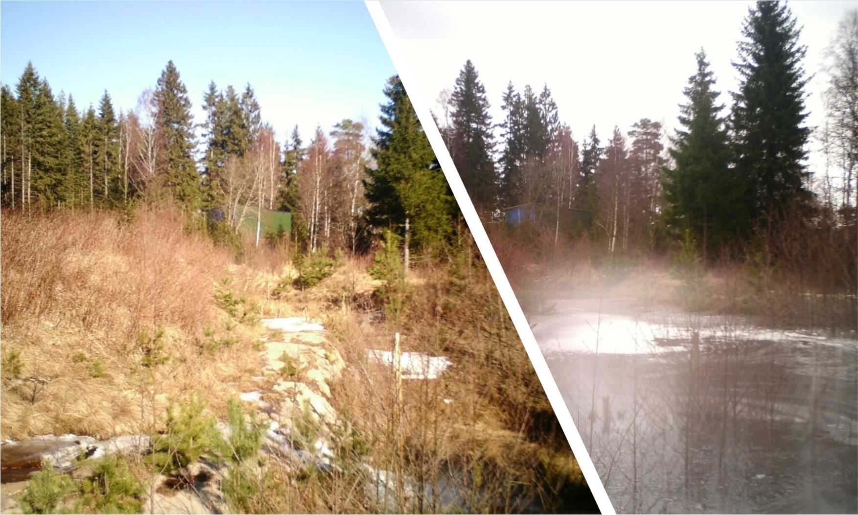
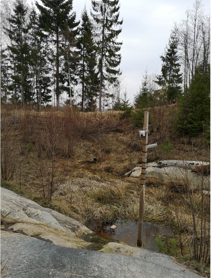
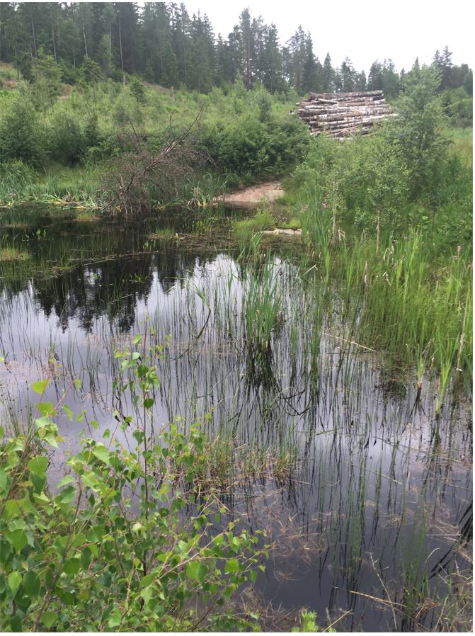
Small retention ponds, located in the forest, are ponds or pools with sufficient storage capacity to store the surface runoff to prevent flooding during heavy rainfall events. Ponds contain limited or no water during dry weather, but are designed to retain water during rain events.
2.2 การอธิบายแบบละเอียดของเทคโนโลยี
คำอธิบาย:
The aim of the small retention ponds is to provide additional storage capacity to hold runoff to attenuate surface runoff - and thus reduce its impact on flooding - during rainfall events. The measure will primarily be useful in connection with short-term extreme episodes and have less effect during prolonged rain – this is because once the dam is filled up it no longer has a flood-reducing effect.
Small retention ponds located in forest areas are artificial dams (up to 2m height, for security reasons) made of soil, stone and/or gabions, with additional storage capacity to attenuate surface runoff during rainfall events. The ponds use local topography to provide space to store discharge peaks. The size of the ponds vary greatly between c. 50-150 m3. The dams can either be established in waterways, or next to the stream so that water is diverted during a flood event. Continuous water flow through the dam is ensured by a spillway located at the bottom of the dam. In this way, the dam can temporarily store water during rainfall episodes and thus decrease the flood peak downstream. The pond must be designed correctly, and calculations of cost-benefit should be carried out before implementation.
As for now, the implementation of small retention ponds in the forests are initiated by landowners. The ponds are getting more and more interest from the local communities however, they are not yet commonly implemented.
In general, there is agreement between experts (researchers) and other stakeholders about the benefits of the implementation of small retention ponds in the forest. However, it is not always the case that such retention ponds decrease floods - as the level of influence depends on the scale and the number of ponds within the catchment. When it comes to drawbacks, stakeholders were particularly worried about the cost of building and maintaining the retention ponds as well as the security of the construction. They placed less emphasis on possible decreases in forest production, which was one of the disadvantages identified by researchers.
Information about the technology is based on investigations and/or reports from different catchments in Norway. For the purpose of the OPTAIN project, the technology is further presented in the natural and human environment context of the Kråkstad River catchment - a Norwegian Case Study catchment within the OPTAIN project.
The Kråkstad River is mainly situated in Ski municipality in South-Eastern parts of Norway. The river catchment is a western tributary of the Vansjø-Hobøl watercourse, also known as the Morsa watercourse. The Kråkstad River catchment area is about 51 km², 43% of which is agricultural land, where cereals are produced on heavy clay soils. The main environmental challenge in the area is water quality (incl. high phosphorus pollution) and soil erosion (incl. riverbank erosion and quick-clay landslides).The Morsa watercourse is a drinking water resource and there are specific environmental regulations for land management followed by subsidies through the Regional Environmental Programme (RMP).
2.3 รูปภาพของเทคโนโลยี
อัลบั้มสื่อบันทึก
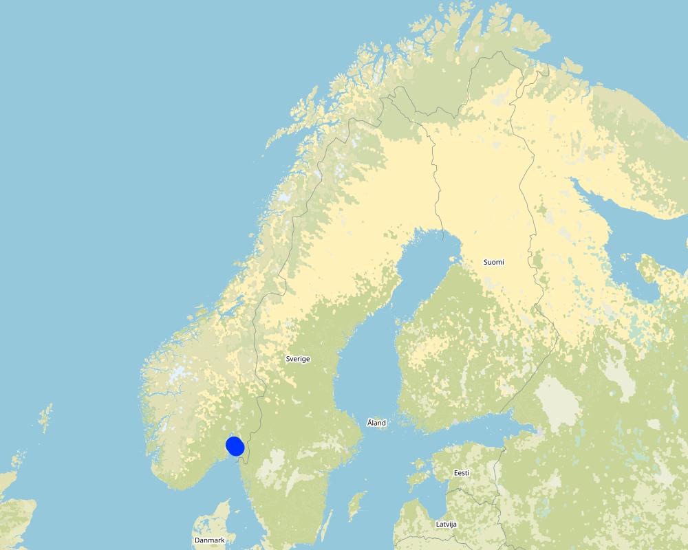
2.5 ประเทศภูมิภาค หรือสถานที่ตั้งที่เทคโนโลยีได้นำไปใช้และได้รับการครอบคลุมโดยการประเมินนี้
ประเทศ:
นอร์เวย์
ภูมิภาค/รัฐ/จังหวัด:
Viken county
ข้อมูลจำเพาะเพิ่มเติมของสถานที่ตั้ง :
The Vansjø - Hobøl catchment
ระบุการกระจายตัวของเทคโนโลยี:
- ใช้ ณ จุดที่เฉพาะเจาะจงหรือเน้นไปยังบริเวณพื้นที่ขนาดเล็ก
Is/are the technology site(s) located in a permanently protected area?
ไม่ใช่
Map
×2.6 วันที่การดำเนินการ
ถ้าไม่รู้ปีที่แน่นอน ให้ระบุวันที่โดยประมาณ:
- น้อยกว่า 10 ปี (ไม่นานนี้)
2.7 คำแนะนำของเทคโนโลยี
ให้ระบุว่าเทคโนโลยีถูกแนะนำเข้ามาอย่างไร:
- ด้วยการริเริ่มของผู้ใช้ที่ดินเอง
- ในช่วงการทดลองหรือการทำวิจัย
- SMIL
ความคิดเห็น (ประเภทของโครงการ เป็นต้น) :
Establishment of the retention ponds presented in this documentation was initiated by landowners. Monitoring of their effectiveness was part of the research project (RECARE: https://www.recare-hub.eu/).
Retention ponds are part of SMIL subside system (Special Environmental measures in Agriculture)
3. การจัดประเภทของเทคโนโลยี SLM
3.1 วัตถุประสงค์หลักของเทคโนโลยี
- ลด ป้องกัน ฟื้นฟู การเสื่อมโทรมของที่ดิน
- รักษาสภาพหรือปรับปรุงความหลากหลายทางชีวภาพ
- ลดความเสี่ยงของภัยพิบัติ
- ปรับตัวเข้ากับการเปลี่ยนแปลงภูมิอากาศของโลก สภาพภูมิอากาศที่รุนแรงและผลกระทบ
- ชะลอการเปลี่ยนแปลงภูมิอากาศของโลกและผลกระทบ
3.2 ประเภทของการใช้ที่ดินในปัจจุบันที่ได้นำเทคโนโลยีไปใช้
Land use mixed within the same land unit:
ไม่ใช่

ป่า/พื้นที่ทำไม้
- natural forest
3.3 Has land use changed due to the implementation of the Technology?
Has land use changed due to the implementation of the Technology?
- No (Continue with question 3.4)
3.4 การใช้น้ำ
การใช้น้ำของที่ดินที่มีการใช้เทคโนโลยีอยู่:
- จากน้ำฝน
3.5 กลุ่ม SLM ที่ตรงกับเทคโนโลยีนี้
- การผันน้ำและการระบายน้ำ
- การจัดการน้ำผิวดิน (น้ำพุ แม่น้ำทะเลสาบ ทะเล)
3.6 มาตรการ SLM ที่ประกอบกันเป็นเทคโนโลยี

มาตรการอนุรักษ์ด้วยโครงสร้าง
- S5: เขื่อน ชั้นดินที่แน่นแข็งบ่อน้ำ
3.7 รูปแบบหลักของการเสื่อมโทรมของที่ดินที่ได้รับการแก้ไขโดยเทคโนโลยี

การกัดกร่อนของดินโดยน้ำ
- Wt (Loss of topsoil): การสูญเสียดินชั้นบนหรือการกัดกร่อนที่ผิวดิน
- Wg (Gully erosion): การกัดกร่อนแบบร่องธารหรือการทำให้เกิดร่องน้ำเซาะ
3.8 การป้องกัน การลดลง หรือการฟื้นฟูความเสื่อมโทรมของที่ดิน
ระบุเป้าหมายของเทคโนโลยีกับความเสื่อมโทรมของที่ดิน:
- ป้องกันความเสื่อมโทรมของที่ดิน
- ลดความเสื่อมโทรมของดิน
4. ข้อมูลจำเพาะด้านเทคนิค กิจกรรมการนำไปปฏิบัติใช้ ปัจจัยนำเข้า และค่าใช้จ่าย
4.1 แบบแปลนทางเทคนิคของเทคโนโลยี
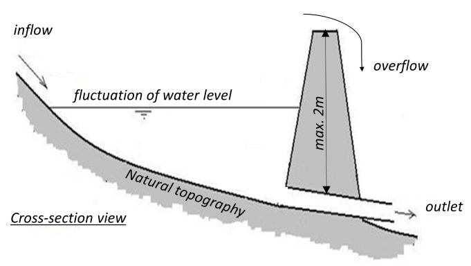
ข้อมูลจำเพาะด้านเทคนิค (แบบแปลนทางเทคนิคของเทคโนโลยี):
Cross-section view on the small retention pond
ผู้เขียน:
Dominika Krzeminska
วันที่:
26/01/2022
4.2 ข้อมูลทั่วไปเกี่ยวกับการคำนวณปัจจัยนำเข้าและค่าใช้จ่าย
ให้ระบุว่าค่าใช้จ่ายและปัจจัยนำเข้าได้รับการคำนวณอย่างไร:
- ต่อหน่วยเทคโนโลยี
โปรดระบุหน่วย:
Pond
Specify dimensions of unit (if relevant):
c. 50-150 m3
อื่นๆ หรือสกุลเงินประจำชาติ (ระบุ):
NOK
If relevant, indicate exchange rate from USD to local currency (e.g. 1 USD = 79.9 Brazilian Real): 1 USD =:
8.89
ระบุค่าเฉลี่ยของค่าจ้างในการจ้างแรงงานต่อวัน:
c.a. 3000 NOK (it is only the cost of the time assuming 8h work per day, 320-500 NOK/hour; person; machinery, equipment, materials not included)
4.3 กิจกรรมเพื่อการจัดตั้ง
| กิจกรรม | Timing (season) | |
|---|---|---|
| 1. | Construct the dam | dry period of the year |
แสดงความคิดเห็น:
We are talking here about “small” dams, up to 2 m (restrictions due to safety regulations). The dams can be built with the use of typical machinery available at the farms: digger, tractor etc. or with help of company.
4.4 ค่าใช้จ่ายของปัจจัยนำเข้าที่จำเป็นสำหรับการจัดตั้ง
If you are unable to break down the costs in the table above, give an estimation of the total costs of establishing the Technology:
35000.0
ถ้าผู้ใช้ที่ดินรับภาระน้อยกว่า 100% ของค่าใช้จ่าย ให้ระบุว่าใครเป็นผู้รับผิดชอบส่วนที่เหลือ:
The landowners can apply for subsidies to establish and maintenance sedimentation pond, within SMIL system (Special Environmental measures in Agriculture). Local county authorities are responsible for the administration of these schemes.
แสดงความคิดเห็น:
Approximately NOK 35,000 has been used to establish the retention pond (monitoried withn RECARE project). It is mostly to rent the equipment and buy the material (soil). The work was done made by the landowner.
4.5 การบำรุงรักษาสภาพหรือกิจกรรมที่เกิดขึ้นเป็นประจำ
| กิจกรรม | ช่วงระยะเวลา/ความถี่ | |
|---|---|---|
| 1. | Maintenance of the dam | on demand |
| 2. | Maintenance of the pond area | on demand |
4.6 ค่าใช้จ่ายของปัจจัยนำเข้าและกิจกรรมที่เกิดขึ้นเป็นประจำที่ต้องการการบำรุงรักษา (ต่อปี)
If you are unable to break down the costs in the table above, give an estimation of the total costs of maintaining the Technology:
10000.0
ถ้าผู้ใช้ที่ดินรับภาระน้อยกว่า 100% ของค่าใช้จ่าย ให้ระบุว่าใครเป็นผู้รับผิดชอบส่วนที่เหลือ:
The landowners can apply for subsidies to establish and maintenance sedimentation pond, within SMIL system (Special Environmental measures in Agriculture). Local county authorities are responsible for the administration of these schemes.
แสดงความคิดเห็น:
An estimate for maintenance costs is set at NOK 10,000 annually, most of it is for clearing the area.
4.7 ปัจจัยสำคัญที่สุดที่มีผลกระทบต่อค่าใช้จ่าย
ปัจจัยสำคัญที่สุดที่มีผลกระทบต่อค่าใช้จ่ายต่างๆ:
- The terrain setup,
- Type of material used to construct the dam and its durability (establishment and maintenance costs).
- Need for maintenance
The landowners can apply for subsidies to establish and maintenance sedimentation pond, within SMIL system (Special Environmental measures in Agriculture). Local county authorities are responsible for the administration of these schemes.
5. สิ่งแวดล้อมทางธรรมชาติและของมนุษย์
5.1 ภูมิอากาศ
ฝนประจำปี
- < 250 ม.ม.
- 251-500 ม.ม.
- 501-750 ม.ม.
- 751-1,000 ม.ม.
- 1,001-1,500 ม.ม.
- 1,501-2,000 ม.ม.
- 2,001-3,000 ม.ม.
- 3,001-4,000 ม.ม.
- > 4,000 ม.ม.
เขตภูมิอากาศเกษตร
- ชื้น
5.2 สภาพภูมิประเทศ
ค่าเฉลี่ยความลาดชัน:
- ราบเรียบ (0-2%)
- ลาดที่ไม่ชัน (3-5%)
- ปานกลาง (6-10%)
- เป็นลูกคลื่น (11-15%)
- เป็นเนิน (16-30%)
- ชัน (31-60%)
- ชันมาก (>60%)
ธรณีสัณฐาน:
- ที่ราบสูง/ที่ราบ
- สันเขา
- ไหล่เขา
- ไหล่เนินเขา
- ตีนเนิน
- หุบเขา
ระดับความสูง:
- 0-100 เมตร
- 101-500 เมตร
- 501-1,000 เมตร
- 1,001-1,500 เมตร
- 1,501-2,000 เมตร
- 2,001-2,500 เมตร
- 2,501-3,000 เมตร
- 3,001-4,000 เมตร
- > 4,000 เมตร
5.3 ดิน
ค่าเฉลี่ยความลึกของดิน:
- ตื้นมาก (0-20 ซ.ม.)
- ตื้น (21-50 ซ.ม.)
- ลึกปานกลาง (51-80 ซ.ม.)
- ลึก (81-120 ซ.ม.)
- ลึกมาก (>120 ซ.ม.)
เนื้อดิน (ดินชั้นบน):
- ปานกลาง (ดินร่วน ทรายแป้ง)
- ละเอียด/หนัก (ดินเหนียว)
เนื้อดินล่าง (> 20 ซ.ม.ต่ำจากผิวดิน):
- ปานกลาง (ดินร่วน ทรายแป้ง)
- ละเอียด/หนัก (ดินเหนียว)
อินทรียวัตถุในดิน:
- ปานกลาง (1-3%)
5.4 ความเป็นประโยชน์และคุณภาพของน้ำ
ระดับน้ำใต้ดิน:
<5 เมตร
น้ำไหลบ่าที่ผิวดิน:
ดี
คุณภาพน้ำ (ที่ยังไม่ได้บำบัด):
เป็นน้ำใช้เพื่อการเกษตรเท่านั้น (การชลประทาน)
Water quality refers to:
both ground and surface water
ความเค็มของน้ำเป็นปัญหาหรือไม่:
ไม่ใช่
กำลังเกิดน้ำท่วมในพื้นที่หรือไม่:
ใช่
บ่อยครั้ง:
บ่อยครั้ง
5.5 ความหลากหลายทางชีวภาพ
ความหลากหลายทางชนิดพันธุ์:
- ปานกลาง
ความหลากหลายของแหล่งที่อยู่:
- ปานกลาง
5.6 ลักษณะของผู้ใช้ที่ดินที่นำเทคโนโลยีไปปฏิบัติใช้
อยู่กับที่หรือเร่ร่อน:
- อยู่กับที่
แนวทางการตลาดของระบบการผลิต:
- mixed (subsistence/ commercial)
รายได้ที่มาจากนอกฟาร์ม:
- > 50% ของรายได้ทั้งหมด
ระดับของความมั่งคั่งโดยเปรียบเทียบ:
- พอมีพอกิน
- รวย
เป็นรายบุคคล/ครัวเรือน:
- เป็นรายบุคคล/ครัวเรือน
ระดับของการใช้เครื่องจักรกล:
- การใช้เครื่องจักรหรือเครื่องยนต์
เพศ:
- หญิง
- ชาย
อายุของผู้ใช้ที่ดิน:
- ผู้เยาว์
- วัยกลางคน
5.7 Average area of land used by land users applying the Technology
- < 0.5 เฮกตาร์
- 0.5-1 เฮกตาร์
- 1-2 เฮกตาร์
- 2-5 เฮกตาร์
- 5-15 เฮกตาร์
- 15-50 เฮกตาร์
- 50-100 เฮกตาร์
- 100-500 เฮกตาร์
- 500-1,000 เฮกตาร์
- 1,000-10,000 เฮกตาร์
- >10,000 เฮกตาร์
5.8 กรรมสิทธิ์ในที่ดิน สิทธิในการใช้ที่ดินและสิทธิในการใช้น้ำ
กรรมสิทธิ์ในที่ดิน:
- รายบุคคล ได้รับสิทธิครอบครอง
สิทธิในการใช้ที่ดิน:
- เกี่ยวกับชุมชน (ถูกจัดระเบียบ)
- รายบุคคล
สิทธิในการใช้น้ำ:
- เข้าถึงได้แบบเปิด (ไม่ได้จัดระเบียบ)
5.9 การเข้าถึงบริการและโครงสร้างพื้นฐาน
สุขภาพ:
- จน
- ปานกลาง
- ดี
การศึกษา:
- จน
- ปานกลาง
- ดี
ความช่วยเหลือทางด้านเทคนิค:
- จน
- ปานกลาง
- ดี
การจ้างงาน (เช่น ภายนอกฟาร์ม):
- จน
- ปานกลาง
- ดี
ตลาด:
- จน
- ปานกลาง
- ดี
พลังงาน:
- จน
- ปานกลาง
- ดี
ถนนและการขนส่ง:
- จน
- ปานกลาง
- ดี
น้ำดื่มและการสุขาภิบาล:
- จน
- ปานกลาง
- ดี
บริการด้านการเงิน:
- จน
- ปานกลาง
- ดี
6. ผลกระทบและสรุปคำบอกกล่าว
6.1 ผลกระทบในพื้นที่ดำเนินการ (On-site) จากการใช้เทคโนโลยี
ผลกระทบทางด้านเศรษฐกิจและสังคม
การผลิต
การผลิตพืชผล
การเสี่ยงต่อความล้มเหลวในการผลิต
พื้นที่สำหรับการผลิต
รายได้และค่าใช้จ่าย
รายได้จากฟาร์ม
แสดงความคิดเห็น/ระบุ:
Less flooding events--> crop grown
ผลกระทบด้านนิเวศวิทยา
ดิน
การสูญเสียดิน
แสดงความคิดเห็น/ระบุ:
Less flooding events--> lower soil erosion
ความหลากหลายทางชีวภาพของพืชและสัตว์
ความหลากหลายทางชีวภาพของพืช
ความหลากหลายทางชีวภาพของสัตว์
ความหลากหลายของสัตว์
6.2 ผลกระทบนอกพื้นที่ดำเนินการ (Off-site) จากการใช้เทคโนโลยี
น้ำท่วมพื้นที่ท้ายน้ำ
แสดงความคิดเห็น/ระบุ:
Depending on the scale and number of retention pond in the catchment, it may affect the discharge behavior of the river system (less peak flows).
6.3 การเผชิญและความตอบสนองของเทคโนโลยีต่อการเปลี่ยนแปลงสภาพภูมิอากาศที่ค่อยเป็นค่อยไป และสภาพรุนแรงของภูมิอากาศ / ภัยพิบัติ (ที่รับรู้ได้โดยผู้ใช้ที่ดิน)
การเปลี่ยนแปลงสภาพภูมิอากาศที่ค่อยเป็นค่อยไป
การเปลี่ยนแปลงสภาพภูมิอากาศที่ค่อยเป็นค่อยไป
| ฤดู | increase or decrease | เทคโนโลยีมีวิธีการรับมืออย่างไร | |
|---|---|---|---|
| อุณหภูมิประจำปี | เพิ่มขึ้น | ดี | |
| ฝนตามฤดู | ฤดูฝน | เพิ่มขึ้น | ดี |
สภาพรุนแรงของภูมิอากาศ (ภัยพิบัติ)
ภัยพิบัติทางอุตุนิยมวิทยา
| เทคโนโลยีมีวิธีการรับมืออย่างไร | |
|---|---|
| พายุฝนประจำท้องถิ่น | ปานกลาง |
| พายุลมประจำท้องถิ่น | ดี |
ภัยพิบัติจากน้ำ
| เทคโนโลยีมีวิธีการรับมืออย่างไร | |
|---|---|
| น้ำท่วมตามปกติ (แม่น้ำ) | ดี |
6.4 การวิเคราะห์ค่าใช้จ่ายและผลประโยชน์ที่ได้รับ
ผลประโยชน์ที่ได้รับเปรียบเทียบกับค่าใช้จ่ายในการจัดตั้งเป็นอย่างไร (จากมุมมองของผู้ใช้ที่ดิน)
ผลตอบแทนระยะสั้น:
เป็นกลางหรือสมดุล
ผลตอบแทนระยะยาว:
ด้านบวก
ผลประโยชน์ที่ได้รับเปรียบเทียบกับค่าใช้จ่ายในการบำรุงรักษาหรือต้นทุนที่เกิดขึ้นซ้ำอีก เป็นอย่างไร (จากมุมมองของผู้ใช้ที่ดิน)
ผลตอบแทนระยะสั้น:
ด้านบวกเล็กน้อย
ผลตอบแทนระยะยาว:
ด้านบวก
6.5 การปรับตัวของเทคโนโลยี
- ครั้งเดียวหรือเป็นการทดลอง
Of all those who have adopted the Technology, how many did so spontaneously, i.e. without receiving any material incentives/ payments?
- 91-100%
6.6 การปรับตัว
เทคโนโลยีได้รับการปรับเปลี่ยนเมื่อเร็วๆนี้ เพื่อให้ปรับตัวเข้ากับสภาพที่กำลังเปลี่ยนแปลงหรือไม่:
ไม่ใช่
6.7 จุดแข็ง / ข้อได้เปรียบ / โอกาสของเทคโนโลยี
| จุดแข็ง / ข้อได้เปรียบ / โอกาสในทัศนคติของผู้ใช้ที่ดิน |
|---|
| Improvement of the water conditions down-slope: reduce amount of overland flow and lower erosion rate in the agriculture land located below the pond. |
| จุดแข็ง / ข้อได้เปรียบ / โอกาสในทัศนคติของผู้รวบรวมหรือวิทยากรหลัก |
|---|
| Depending on the scale and number of retention pond in the catchment, it may affect the discharge behaviour of the river system (lower peak flows) |
6.8 จุดอ่อน / ข้อเสียเปรียบ / ความเสี่ยงของเทคโนโลยีและวิธีการแก้ไข
| จุดอ่อน / ข้อเสียเปรียบ / ความเสี่ยงในทัศนคติของผู้ใช้ที่ดิน | มีวิธีการแก้ไขได้อย่างไร |
|---|---|
| Security of the construction | |
| Costs of maintenance |
| จุดอ่อน / ข้อเสียเปรียบ / ความเสี่ยงในทัศนคติของผู้รวบรวมหรือวิทยากรหลัก | มีวิธีการแก้ไขได้อย่างไร |
|---|---|
| Decreases in forest prodcution |
7. การอ้างอิงและการเชื่อมต่อ
7.1 วิธีการและแหล่งข้อมูล
- ไปเยี่ยมชมภาคสนาม การสำรวจพื้นที่ภาคสนาม
Several field visits during the course of RECARE project (2014-2018).
- การสัมภาษณ์กับผู้ใช้ที่ดิน
Stakeholders workshops carried out within RECARE project.
- การสัมภาษณ์ผู้เชี่ยวชาญด้าน SLM หรือผู้ชำนาญ
NIBIO, and its SLM specialists, has been conducting several national projects related to planning and monitoring the efficiency of small retention ponds within agricultural catchments.
- การเก็บรวบรวมมาจากรายงานและเอกสารที่มีอยู่
See the references
วันที่เก็บรวบรวมข้อมูล(ภาคสนาม) :
26/01/2022
7.2 การอ้างอิงถึงสิ่งตีพิมพ์
หัวข้อ, ผู้เขียน, ปี, หมายเลข ISBN:
Fact Sheets: Case study experiments preventing flooding through small retention ponds. Krzeminska D.; Bøe F.; Stolte J. (2018)
ชื่อเรื่อง ผู้เขียน ปี ISBN:
RECARE project website https://www.recare-hub.eu
หัวข้อ, ผู้เขียน, ปี, หมายเลข ISBN:
Assessing Impacts of Soil Management Measures on Ecosystem Services. Schwilch G. et al. (2018)
ชื่อเรื่อง ผู้เขียน ปี ISBN:
Mdpi Sustainability
หัวข้อ, ผู้เขียน, ปี, หมายเลข ISBN:
Helping stakeholders select and apply appraisal tools to mitigate soil threats: Researchers’ experiences from across Europe. Okpara et al (2020)
ชื่อเรื่อง ผู้เขียน ปี ISBN:
Journal of Environmental Management
หัวข้อ, ผู้เขียน, ปี, หมายเลข ISBN:
Fordrøyningsdammer i tilknytning til jordbruksarealer. Stolte J and Barneveld R. (2019)
ชื่อเรื่อง ผู้เขียน ปี ISBN:
NIBIO raport
7.3 Links to relevant online information
ชื่อเรื่องหรือคำอธิบาย:
Fact Sheets: Case study experiments preventing flooding through small retention ponds
URL:
https://www.recare-hub.eu/images/articles/Case_Studies/Fact_Sheets/RECARE_Experiment_Fact_Sheet_NorwayPondsFinal.pdf
ชื่อเรื่องหรือคำอธิบาย:
Assessing Impacts of Soil Management Measures on Ecosystem Services
URL:
https://www.mdpi.com/2071-1050/10/12/4416
ชื่อเรื่องหรือคำอธิบาย:
Helping stakeholders select and apply appraisal tools to mitigate soil threats: Researchers’ experiences from across Europe
URL:
https://www.sciencedirect.com/science/article/pii/S0301479719317232?via%253Dihub
ชื่อเรื่องหรือคำอธิบาย:
Fordrøyningsdammer i tilknytning til jordbruksarealer.
URL:
https://nibio.brage.unit.no/nibio-xmlui/bitstream/handle/11250/2606099/NIBIO_RAPPORT_2019_5_65.pdf?sequence=1&isAllowed=y
7.4 General comments
no remarks
ลิงก์และโมดูล
ขยายทั้งหมด ย่อทั้งหมดลิงก์
Regional Environmental program [นอร์เวย์]
Regulations and financial grants for reduction of pollution and promotion of the cultural landscape.
- ผู้รวบรวม: Kamilla Skaalsveen
โมดูล
ไม่มีโมดูล