Intensive agroforestry system [โคลอมเบีย]
- ผู้สร้างสรรค์:
- การอัพเดท:
- ผู้รวบรวม: Mathias Gurtner
- ผู้เรียบเรียง: –
- ผู้ตรวจสอบ: Deborah Niggli, Alexandra Gavilano
Silvoagricultura (spanish)
technologies_1023 - โคลอมเบีย
ดูส่วนย่อย
ขยายทั้งหมด ย่อทั้งหมด1. ข้อมูลทั่วไป
1.2 รายละเอียดที่ติดต่อได้ของผู้รวบรวมและองค์กรที่เกี่ยวข้องในการประเมินและการจัดเตรียมทำเอกสารของเทคโนโลยี
ชื่อของโครงการซึ่งอำนวยความสะดวกในการทำเอกสารหรือการประเมินเทคโนโลยี (ถ้าเกี่ยวข้อง)
Book project: where the land is greener - Case Studies and Analysis of Soil and Water Conservation Initiatives Worldwide (where the land is greener)1.3 เงื่อนไขการใช้ข้อมูลที่ได้บันทึกผ่านทาง WOCAT
ผู้รวบรวมและวิทยากรหลักยอมรับเงื่อนไขเกี่ยวกับการใช้ข้อมูลที่ถูกบันทึกผ่านทาง WOCAT:
ใช่
1.4 การเปิดเผยเรื่องความยั่งยืนของเทคโนโลยีที่ได้อธิบายไว้
เทคโนโลยีที่ได้อธิบายไว้นี้เป็นปัญหาของความเสื่อมโทรมโทรมของที่ดินหรือไม่ จึงไม่ได้รับการยอมรับว่าเป็นเทคโนโลยีเพื่อการจัดการที่ดินอย่างยั่งยืน:
ไม่ใช่
1.5 Reference to Questionnaire(s) on SLM Approaches (documented using WOCAT)
Desarrollo Rural Integral Comunitario [โคลอมเบีย]
En un proceso participativo y comunitario y a través de la capacitación, la asistencia técnica y la suministración de insumos importantes se fomenta el establecimiento de un sistema agrosilicultural en la comunidad indÃgena.
- ผู้รวบรวม: Mathias Gurtner
2. การอธิบายลักษณะของเทคโนโลยี SLM
2.1 การอธิบายแบบสั้น ๆ ของเทคโนโลยี
คำจำกัดความของเทคโนโลยี:
A protective and productive high-input agroforestry system comprising multi-purpose ditches with bunds, live barriers of grass, contour ridging,
annual crops and fruit trees.
2.2 การอธิบายแบบละเอียดของเทคโนโลยี
คำอธิบาย:
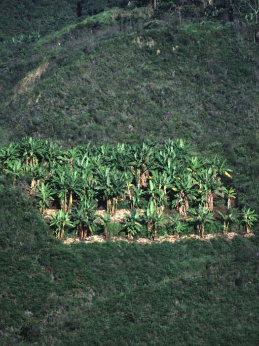
The intensive agroforestry system (silvoagricultura) combines traditional and newly developed practices adapted to the area’s conditions. The idea is to concentrate cropping on a limited area, a plot of 0.4 ha per household, in a highly integrated, intensive and diversified continuous land use system, thereby integrating soil and water conservation - specifically avoiding traditional slash and burn practices.
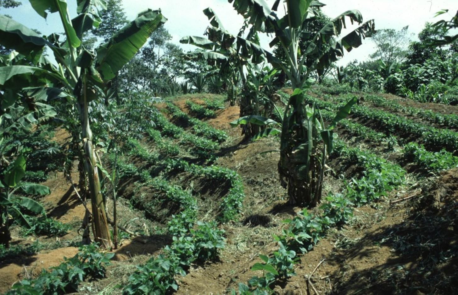
Each ‘agroforestry plot’ comprises four to five 50 cm wide and 40 m long multipurpose ditches that are excavated along the contour, 6 to 12 m apart, depending on the slope. The ditches retain runoff water which infiltrates the soil, thus reducing erosion and improving soil moisture. They also act as compost ditches for all types of organic residues on the farm. Residues, enriched with manure (from chickens and guinea pigs) are tipped into the ditches, and within 8 to12 months this decomposes into a fertile medium for the cultivation of vegetables and other crops.
The main purpose is to increase and diversify production, and at the same time to protect natural resources and regenerate degraded areas.
Grass strips are planted on the earth bund on the upper side of the ditch for stabilisation of the structure, retention of runoff and capture of eroded sediment. The grass is cut several times a year to feed guinea pigs, which in turn recycle this into manure. On the lower side of the contour ditches, fruit trees and bananas are planted. Rows of multipurpose trees (mainly indigenous species) are planted around each agroforestry plot as a windbreak and for economic reasons: yielding fruit and timber. Between the structures, annual (and semi-perennial) crops are grown on hand-dug micro-terraces/ridges, again sited along the contour. Some farmers intercrop with legumes. Supportive technologies are protection of wells,
afforestation and, where possible, irrigation to enhance production. Production is based on principles of organic farming.High initial inputs of external manure are subsidised by the project (CISEC; see associated approach). The remainder of each farmer’s land is left to natural regeneration, reforested, or where needed, used for conventional cropping
The system is implemented on degraded and often steep slopes in subhumid areas where intensive rainfall and dry periods alternate. The land is officially owned communally (an ‘Indigenous Reserve’), but land use rights are individual. The region has a high population density: people are basically of indigenous origin and live in very poor conditions.
2.3 รูปภาพของเทคโนโลยี
อัลบั้มสื่อบันทึก
2.5 ประเทศภูมิภาค หรือสถานที่ตั้งที่เทคโนโลยีได้นำไปใช้และได้รับการครอบคลุมโดยการประเมินนี้
ประเทศ:
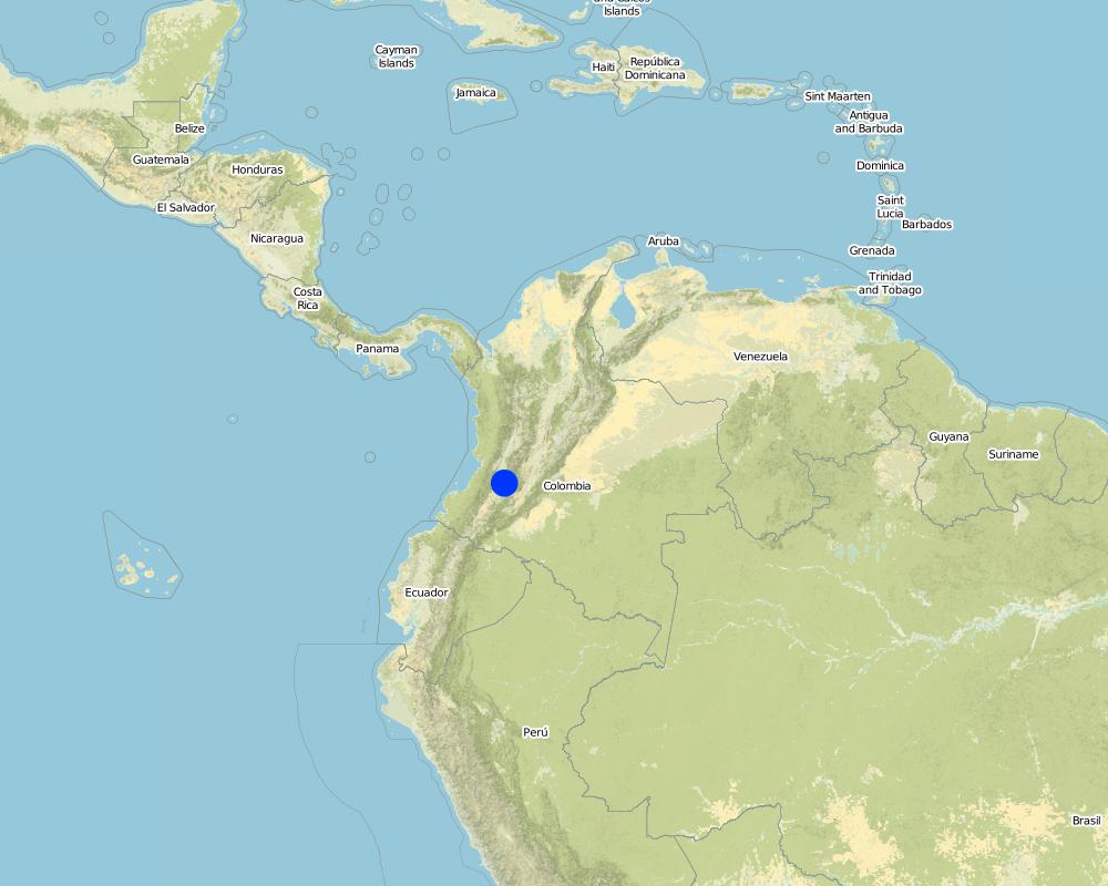
โคลอมเบีย
ภูมิภาค/รัฐ/จังหวัด:
Cauca
ข้อมูลจำเพาะเพิ่มเติมของสถานที่ตั้ง :
Santander de Quilichao
ระบุการกระจายตัวของเทคโนโลยี:
- กระจายไปอย่างสม่ำเสมอในพื้นที่
If the Technology is evenly spread over an area, specify area covered (in km2):
1.2
แสดงความคิดเห็น:
Total area covered by the SLM Technology is 1.2 km2.
Map
×2.7 คำแนะนำของเทคโนโลยี
ให้ระบุว่าเทคโนโลยีถูกแนะนำเข้ามาอย่างไร:
- ทางโครงการหรือจากภายนอก
3. การจัดประเภทของเทคโนโลยี SLM
3.1 วัตถุประสงค์หลักของเทคโนโลยี
- ปรับปรุงการผลิตให้ดีขึ้น
- ลด ป้องกัน ฟื้นฟู การเสื่อมโทรมของที่ดิน
3.2 ประเภทของการใช้ที่ดินในปัจจุบันที่ได้นำเทคโนโลยีไปใช้
Land use mixed within the same land unit:
ใช่
Specify mixed land use (crops/ grazing/ trees):
- วนเกษตร (Agroforestry)

พื้นที่ปลูกพืช
- การปลูกพืชล้มลุกอายุปีเดียว
- การปลูกไม้ยืนต้น ไม้พุ่ม
ระบุ:
Longest growing period in days: 240, Longest growing period from month to month: october untill may
Is intercropping practiced?
ใช่
แสดงความคิดเห็น:
Major land use problems (compiler’s opinion): - soil degradation/reduced soil fertility
- inappropriate soil management: monoculture, slash and burn, no or short fallow periods
- intensive rainfall on steep, unprotected slopes
- drought and wind erosion in dry season
- lack of economic resources
- high population density
3.4 การใช้น้ำ
การใช้น้ำของที่ดินที่มีการใช้เทคโนโลยีอยู่:
- จากน้ำฝน
3.5 กลุ่ม SLM ที่ตรงกับเทคโนโลยีนี้
- การปลูกป่าร่วมกับพืช
- การปรับปรุงดิน / พืชคลุมดิน
- มาตรการปลูกพืชขวางความลาดชัน (cross-slope measure)
3.6 มาตรการ SLM ที่ประกอบกันเป็นเทคโนโลยี

มาตรการจัดการพืช
- A1: พืช/สิ่งปกคลุมดิน

มาตรการอนุรักษ์ด้วยวิธีพืช
- V1: ต้นไม้และพุ่มไม้คลุมดิน
- V2: หญ้าและไม้ยืนต้น

มาตรการอนุรักษ์ด้วยโครงสร้าง
- S2: ทำนบ เขื่อนดิน
- S3: Graded ditches, channels, waterways
- S4: คูน้ำแนวระดับ หลุม
แสดงความคิดเห็น:
Type of agronomic measures: mixed cropping / intercropping, manure / compost / residues
3.7 รูปแบบหลักของการเสื่อมโทรมของที่ดินที่ได้รับการแก้ไขโดยเทคโนโลยี

การกัดกร่อนของดินโดยน้ำ
- Wt (Loss of topsoil): การสูญเสียดินชั้นบนหรือการกัดกร่อนที่ผิวดิน

การกัดกร่อนของดินโดยลม
- Et (Loss of topsoil): การสูญเสียดินชั้นบน

การเสื่อมโทรมของดินทางด้านเคมี
- Cn (Fertility decline): ความอุดมสมบูรณ์และปริมาณอินทรียวัตถุในดินถูกทำให้ลดลงไป (ไม่ได้เกิดจากสาเหตุการกัดกร่อน)
แสดงความคิดเห็น:
Main causes of degradation: crop management (annual, perennial, tree/shrub) (inadequate management of land with steep slopes), overgrazing (prior degradation by landowner's livestock), industrial activities and mining (degradation of gold mining and other products), education, access to knowledge and support services, inter-generational subdivision of land (traditional custom)
Secondary causes of degradation: deforestation / removal of natural vegetation (incl. forest fires) (primary forest alomst disappeared), poverty / wealth (lack of capital, poverty and further agricultural employers)
3.8 การป้องกัน การลดลง หรือการฟื้นฟูความเสื่อมโทรมของที่ดิน
ระบุเป้าหมายของเทคโนโลยีกับความเสื่อมโทรมของที่ดิน:
- ลดความเสื่อมโทรมของดิน
4. ข้อมูลจำเพาะด้านเทคนิค กิจกรรมการนำไปปฏิบัติใช้ ปัจจัยนำเข้า และค่าใช้จ่าย
4.1 แบบแปลนทางเทคนิคของเทคโนโลยี
ข้อมูลจำเพาะด้านเทคนิค (แบบแปลนทางเทคนิคของเทคโนโลยี):
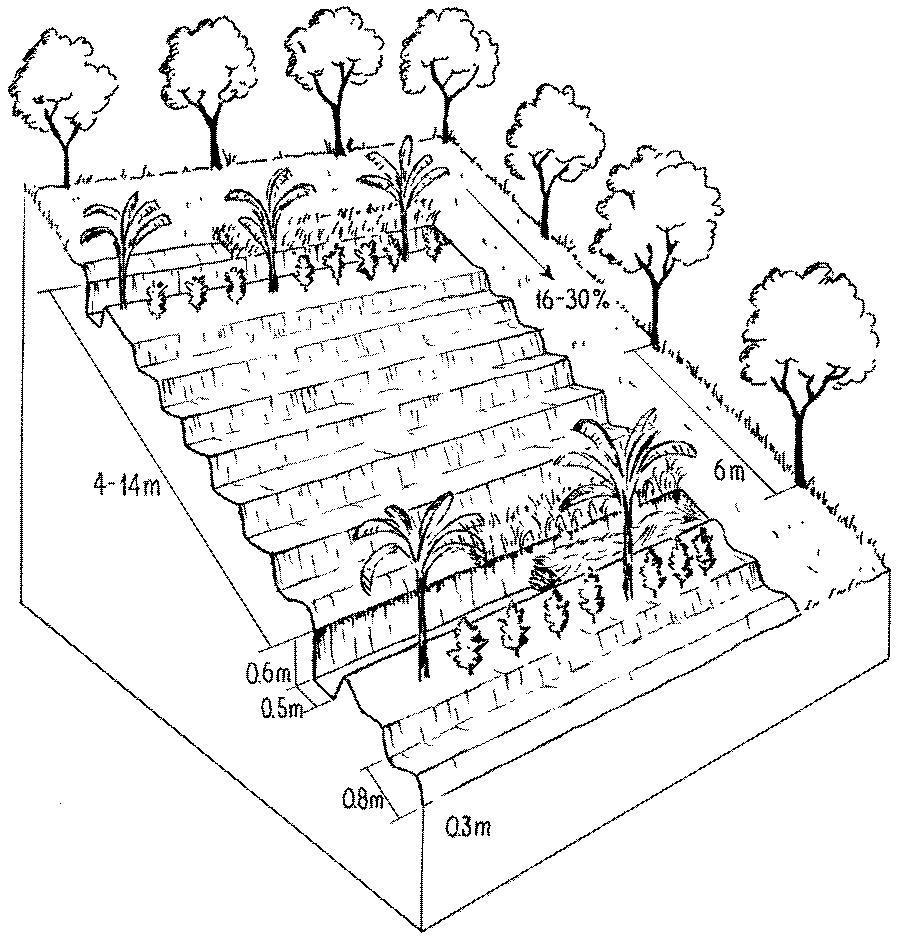
Detailed overview of the complex and intensive high-input, high output agroforestry system, usually limited to an area of 64 x 64 metres.
The agroforestry plots are bordered by trees of various species. Note the multipurpose ditches that serve as compost pits (lower ditch, right). Associated bunds are covered by grass (right).
Technical knowledge required for field staff / advisors: high
Technical knowledge required for land users: moderate
Main technical functions: control of raindrop splash, control of dispersed runoff: impede / retard, reduction of slope length, increase in organic matter, increase in nutrient availability (supply, recycling,…), increase / maintain water stored in soil
Secondary technical functions: reduction of slope angle, improvement of ground cover, increase of infiltration, sediment retention / trapping, sediment harvesting, reduction in wind speed
Vegetative measure: bananas
Vegetative material: F : fruit trees / shrubs
Vegetative measure: Vegetative material: F : fruit trees / shrubs
Slope (which determines the spacing indicated above): 16-30%
ผู้เขียน:
Mats Gurtner
4.3 กิจกรรมเพื่อการจัดตั้ง
| กิจกรรม | Timing (season) | |
|---|---|---|
| 1. | 1. Clear land (only slashing, no burning). | Beginning of rainy season (April) |
| 2. | 2. Determine contours with A-frame, spacing between structures dependson slope (4 m between ditches on steepest slopes, 14 m on gentle slopes). | Beginning of rainy season (April) |
| 3. | 3. Dig ditches, build bunds above, and dig holes for tree seedlings. | Beginning of rainy season (April) |
| 4. | 4. Establish micro-terraces/ridges (earth enriched with manure and residues:all structures along the contour). | During the dry season (June to September) |
| 5. | 6. Plant grass strips on the bund (for stabilisation of structure). | During the dry season (June to September) |
| 6. | 7. Plant fruit/banana trees and legumes below the bunds. | During the dry season (June to September) |
| 7. | 8. Plant fruit and timber trees along the boundaries of the agroforestry | During the dry season (June to September) |
4.4 ค่าใช้จ่ายของปัจจัยนำเข้าที่จำเป็นสำหรับการจัดตั้ง
| ปัจจัยนำเข้า | หน่วย | ปริมาณ | ค่าใช้จ่ายต่อหน่วย | ค่าใช้จ่ายทั้งหมดต่อปัจจัยนำเข้า | %ของค่าใช้จ่ายที่ก่อให้เกิดขึ้นโดยผู้ใช้ที่ดิน | |
|---|---|---|---|---|---|---|
| แรงงาน | labour | ha | 1.0 | 220.0 | 220.0 | 100.0 |
| วัสดุด้านพืช | seeds | ha | 1.0 | 15.0 | 15.0 | 5.0 |
| วัสดุด้านพืช | seedlings | ha | 1.0 | 450.0 | 450.0 | 5.0 |
| ปุ๋ยและสารฆ่า/ยับยั้งการเจริญเติบโตของสิ่งมีชีวิต (ไบโอไซด์) | compost/manure | ha | 1.0 | 600.0 | 600.0 | 5.0 |
| ค่าใช้จ่ายทั้งหมดของการจัดตั้งเทคโนโลยี | 1285.0 | |||||
| Total costs for establishment of the Technology in USD | 1285.0 | |||||
แสดงความคิดเห็น:
Duration of establishment phase: 12 month(s)
4.5 การบำรุงรักษาสภาพหรือกิจกรรมที่เกิดขึ้นเป็นประจำ
| กิจกรรม | ช่วงระยะเวลา/ความถี่ | |
|---|---|---|
| 1. | 5. Fill ditches with organic residues, adding earth mixed with manure. | During the dry season (June to September) / initial establishment |
| 2. | 4. Fill ditches with organic material, residues (after harvest), manure, etcand let it decompose. | |
| 3. | 6. Dig out compost and spread | (beginning of growing season (September) / |
| 4. | 7. Apply additional fertilizer/manure | / 3 times/year |
| 5. | 1. Cut grass ( grass used to feed guinea pigs). | /4–6 times/year |
| 6. | 2. Control weeds | /3 times/year |
| 7. | 5. Plant vegetables on fertile composted earth in ditches | /dry season, optional |
| 8. | 8. Plant various crops: contour cropping, intercropping, integrate greenmanures (legumes). | |
| 9. | 3. Rebuild/repair structures | dry season |
4.6 ค่าใช้จ่ายของปัจจัยนำเข้าและกิจกรรมที่เกิดขึ้นเป็นประจำที่ต้องการการบำรุงรักษา (ต่อปี)
| ปัจจัยนำเข้า | หน่วย | ปริมาณ | ค่าใช้จ่ายต่อหน่วย | ค่าใช้จ่ายทั้งหมดต่อปัจจัยนำเข้า | %ของค่าใช้จ่ายที่ก่อให้เกิดขึ้นโดยผู้ใช้ที่ดิน | |
|---|---|---|---|---|---|---|
| แรงงาน | labour | ha | 1.0 | 100.0 | 100.0 | 100.0 |
| ปุ๋ยและสารฆ่า/ยับยั้งการเจริญเติบโตของสิ่งมีชีวิต (ไบโอไซด์) | biocides | ha | 1.0 | 45.0 | 45.0 | 100.0 |
| ค่าใช้จ่ายทั้งหมดของการบำรุงรักษาสภาพเทคโนโลยี | 145.0 | |||||
| Total costs for maintenance of the Technology in USD | 145.0 | |||||
แสดงความคิดเห็น:
Machinery/ tools: machete, shovel, pickaxes, A-frame, planting stick (chuzo)
As an exception in this case study costs are calculated per plot and not per ha, since establishment is strictly limited
to an area of 0.4 ha per household. The remaining area is not treated but left for natural regeneration of vegetation or
conventional farming (if needed). Labour costs vary according to slope: a typical/average situation is given in the tables above (no further details available). Note that for comparison purposes with other technologies on a per hectare basis these costs would equate to US$ 3,135 for establishment and US$ 355 for maintenance.
5. สิ่งแวดล้อมทางธรรมชาติและของมนุษย์
5.1 ภูมิอากาศ
ฝนประจำปี
- < 250 ม.ม.
- 251-500 ม.ม.
- 501-750 ม.ม.
- 751-1,000 ม.ม.
- 1,001-1,500 ม.ม.
- 1,501-2,000 ม.ม.
- 2,001-3,000 ม.ม.
- 3,001-4,000 ม.ม.
- > 4,000 ม.ม.
เขตภูมิอากาศเกษตร
- กึ่งชุ่มชื้น
Thermal climate class: tropics
5.2 สภาพภูมิประเทศ
ค่าเฉลี่ยความลาดชัน:
- ราบเรียบ (0-2%)
- ลาดที่ไม่ชัน (3-5%)
- ปานกลาง (6-10%)
- เป็นลูกคลื่น (11-15%)
- เป็นเนิน (16-30%)
- ชัน (31-60%)
- ชันมาก (>60%)
ธรณีสัณฐาน:
- ที่ราบสูง/ที่ราบ
- สันเขา
- ไหล่เขา
- ไหล่เนินเขา
- ตีนเนิน
- หุบเขา
ระดับความสูง:
- 0-100 เมตร
- 101-500 เมตร
- 501-1,000 เมตร
- 1,001-1,500 เมตร
- 1,501-2,000 เมตร
- 2,001-2,500 เมตร
- 2,501-3,000 เมตร
- 3,001-4,000 เมตร
- > 4,000 เมตร
5.3 ดิน
ค่าเฉลี่ยความลึกของดิน:
- ตื้นมาก (0-20 ซ.ม.)
- ตื้น (21-50 ซ.ม.)
- ลึกปานกลาง (51-80 ซ.ม.)
- ลึก (81-120 ซ.ม.)
- ลึกมาก (>120 ซ.ม.)
เนื้อดิน (ดินชั้นบน):
- หยาบ/เบา (ดินทราย)
- ปานกลาง (ดินร่วน ทรายแป้ง)
อินทรียวัตถุในดิน:
- สูง (>3%)
- ปานกลาง (1-3%)
5.6 ลักษณะของผู้ใช้ที่ดินที่นำเทคโนโลยีไปปฏิบัติใช้
แนวทางการตลาดของระบบการผลิต:
- เพื่อการยังชีพ (หาเลี้ยงตนเอง)
- mixed (subsistence/ commercial)
รายได้ที่มาจากนอกฟาร์ม:
- < 10% ของรายได้ทั้งหมด
ระดับของการใช้เครื่องจักรกล:
- งานที่ใช้แรงกาย
ระบุลักษณะอื่นๆที่เกี่ยวข้องของผู้ใช้ที่ดิน:
Off-farm income specification: most farmers depend economically entirely on their own crop production
5.7 Average area of land used by land users applying the Technology
- < 0.5 เฮกตาร์
- 0.5-1 เฮกตาร์
- 1-2 เฮกตาร์
- 2-5 เฮกตาร์
- 5-15 เฮกตาร์
- 15-50 เฮกตาร์
- 50-100 เฮกตาร์
- 100-500 เฮกตาร์
- 500-1,000 เฮกตาร์
- 1,000-10,000 เฮกตาร์
- >10,000 เฮกตาร์
5.8 กรรมสิทธิ์ในที่ดิน สิทธิในการใช้ที่ดินและสิทธิในการใช้น้ำ
กรรมสิทธิ์ในที่ดิน:
- เป็นแบบชุมชนหรือหมู่บ้าน
- รายบุคคล ไม่ได้รับสิทธิครอบครอง
สิทธิในการใช้ที่ดิน:
- เกี่ยวกับชุมชน (ถูกจัดระเบียบ)
- รายบุคคล
6. ผลกระทบและสรุปคำบอกกล่าว
6.1 ผลกระทบในพื้นที่ดำเนินการ (On-site) จากการใช้เทคโนโลยี
ผลกระทบทางด้านเศรษฐกิจและสังคม
การผลิต
การผลิตพืชผล
การผลิตพืชที่ใช้เลี้ยงปศุสัตว์
คุณภาพพืชที่ใช้เลี้ยงปศุสัตว์
การผลิตไม้
รายได้และค่าใช้จ่าย
รายได้จากฟาร์ม
ความเหลื่อมล้ำทางเศรษฐกิจ
ภาระงาน
ผลกระทบด้านสังคมวัฒนธรรมอื่น ๆ
สถาบันของชุมชน
การบรรเทาความขัดแย้ง
แสดงความคิดเห็น/ระบุ:
friction between participants and non-participants
ผลกระทบด้านนิเวศวิทยา
ดิน
ความชื้นในดิน
สิ่งปกคลุมดิน
การสูญเสียดิน
ความเป็นกรด
แสดงความคิดเห็น/ระบุ:
high content of organic matter
ความหลากหลายทางชีวภาพของพืชและสัตว์
การจัดการศัตรูพืชและโรคพืช
ลดความเสี่ยงของภัยพิบัติ
ความเร็วของลม
6.2 ผลกระทบนอกพื้นที่ดำเนินการ (Off-site) จากการใช้เทคโนโลยี
การไหลของน้ำคงที่และสม่ำเสมอในช่วงฤดูแล้ง
แสดงความคิดเห็น/ระบุ:
use of water for irrigation
การทับถมของดินตะกอนพื้นที่ท้ายน้ำ
การเกิดมลพิษในน้ำบาดาลหรือแม่น้ำ
ตะกอนที่ถูกพัดพามาโดยลม
6.4 การวิเคราะห์ค่าใช้จ่ายและผลประโยชน์ที่ได้รับ
ผลประโยชน์ที่ได้รับเปรียบเทียบกับค่าใช้จ่ายในการจัดตั้งเป็นอย่างไร (จากมุมมองของผู้ใช้ที่ดิน)
ผลตอบแทนระยะสั้น:
ด้านบวก
ผลตอบแทนระยะยาว:
ด้านบวกอย่างมาก
ผลประโยชน์ที่ได้รับเปรียบเทียบกับค่าใช้จ่ายในการบำรุงรักษาหรือต้นทุนที่เกิดขึ้นซ้ำอีก เป็นอย่างไร (จากมุมมองของผู้ใช้ที่ดิน)
ผลตอบแทนระยะสั้น:
ด้านบวก
ผลตอบแทนระยะยาว:
ด้านบวกอย่างมาก
6.5 การปรับตัวของเทคโนโลยี
แสดงความคิดเห็น:
100% of land user families have adopted the Technology with external material support
260 land user families have adopted the Technology with external material support
There is a little trend towards spontaneous adoption of the Technology. There is a slight growing spontaneous adoption by land users living outside the approach area.
6.7 จุดแข็ง / ข้อได้เปรียบ / โอกาสของเทคโนโลยี
| จุดแข็ง / ข้อได้เปรียบ / โอกาสในทัศนคติของผู้รวบรวมหรือวิทยากรหลัก |
|---|
| Rehabilitation of soil fertility over short term |
| Increased and permanent production |
| Increased food security and balanced diet |
| Adapted to very heterogeneous climatic and topographic conditions. |
| Protective-productive system: compromise between land capability class (forest) and cultivation needs |
6.8 จุดอ่อน / ข้อเสียเปรียบ / ความเสี่ยงของเทคโนโลยีและวิธีการแก้ไข
| จุดอ่อน / ข้อเสียเปรียบ / ความเสี่ยงในทัศนคติของผู้รวบรวมหรือวิทยากรหลัก | มีวิธีการแก้ไขได้อย่างไร |
|---|---|
| Rigid design of the technology and fixed guidelines for implementation activities (pre-conditions for incentive support by project) | Give more flexibility to the farmers for individual modifications. |
| High demand for manual labour |
Emphasis on group work, implement in dry season (when labour force is available at the household level). |
| High external inputs at the beginning (makes the technology very expensive) |
Manure is needed to restore soil fertility in the short-term, land users pay the inputs in form of labour in the CISEC; revolving funds and composting ensure manure supplies on the long term. |
| Decreased pH (soil acidity) |
Compensate by ecological improvements such as application of lime and ashes. |
7. การอ้างอิงและการเชื่อมต่อ
7.1 วิธีการและแหล่งข้อมูล
- ไปเยี่ยมชมภาคสนาม การสำรวจพื้นที่ภาคสนาม
- การสัมภาษณ์กับผู้ใช้ที่ดิน
วันที่เก็บรวบรวมข้อมูล(ภาคสนาม) :
01/07/2004
7.2 การอ้างอิงถึงสิ่งตีพิมพ์
หัวข้อ, ผู้เขียน, ปี, หมายเลข ISBN:
CISEC . Establecimiento de Lotes de Silvoagricultura. 1998.
หัวข้อ, ผู้เขียน, ปี, หมายเลข ISBN:
Gurtner M . Bodendegradierung und Bodenkonservierung inden Anden Kolumbiens – Eine Nachhaltigkeitsstudie im Rahmen des WOCAT-Programms, unpublished MSc Thesis, Science Faculty, University of Berne,Centre for Development and Environment. 1999.
ลิงก์และโมดูล
ขยายทั้งหมด ย่อทั้งหมดลิงก์
Desarrollo Rural Integral Comunitario [โคลอมเบีย]
En un proceso participativo y comunitario y a través de la capacitación, la asistencia técnica y la suministración de insumos importantes se fomenta el establecimiento de un sistema agrosilicultural en la comunidad indÃgena.
- ผู้รวบรวม: Mathias Gurtner
โมดูล
ไม่มีโมดูล