Graded Soil bund [เอธิโอเปีย]
- ผู้สร้างสรรค์:
- การอัพเดท:
- ผู้รวบรวม: Unknown User
- ผู้เรียบเรียง: –
- ผู้ตรวจสอบ: Fabian Ottiger, Alexandra Gavilano
Yafer Erken (Amharic)
technologies_1060 - เอธิโอเปีย
ดูส่วนย่อย
ขยายทั้งหมด ย่อทั้งหมด1. ข้อมูลทั่วไป
1.2 รายละเอียดที่ติดต่อได้ของผู้รวบรวมและองค์กรที่เกี่ยวข้องในการประเมินและการจัดเตรียมทำเอกสารของเทคโนโลยี
วิทยากรหลัก
ผู้เชี่ยวชาญ SLM:
Tadel Getachew
Office of Agriculture and Rural Development
เอธิโอเปีย
ชื่อขององค์กรซึ่งอำนวยความสะดวกในการทำเอกสารหรือการประเมินเทคโนโลยี (ถ้าเกี่ยวข้อง)
Ministry of Agriculture and Rural Development (Ministry of Agriculture and Rural Development) - เอธิโอเปีย1.3 เงื่อนไขการใช้ข้อมูลที่ได้บันทึกผ่านทาง WOCAT
ผู้รวบรวมและวิทยากรหลักยอมรับเงื่อนไขเกี่ยวกับการใช้ข้อมูลที่ถูกบันทึกผ่านทาง WOCAT:
ใช่
2. การอธิบายลักษณะของเทคโนโลยี SLM
2.1 การอธิบายแบบสั้น ๆ ของเทคโนโลยี
คำจำกัดความของเทคโนโลยี:
It is an embankment of soil with no gradient along the contour and stablized with grasses, tree/shrub plant species.
2.2 การอธิบายแบบละเอียดของเทคโนโลยี
คำอธิบาย:
The technology cosists of an embankment of soil accross the slope, cutoff drains constructed at a given interval, water ways for disposing runoff from the bunds and cutoff drains, vegetative measures and agronomic practices on cultivated lands. The structures are laid out at a gradient of 1% in order to safely drain excess water. The immidiate result expected is the control of soil erosion, well drained soils control land degradation, decrease slope length and angle and then sustain productivity. The mantainance is frequently done by removing the silt from the channel and repairing the broken part of the bunds and also stablize the bund by planting. The technology is suitable to high rainfall area where crop fields experience seasonal waterlogging. The surplus water needs to be drained by the help of graded channels of smaller gradients. The channels should be properly constructed in a way no channel scour or sediment deposition takes place. Cutoff drains need to be placed at given interval to reinforce the graded bunds. Waterways are paved with stone to avoid channel scour because of the higher gradients involved in waterway construction.
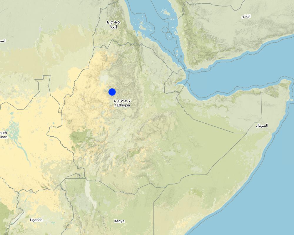
2.5 ประเทศภูมิภาค หรือสถานที่ตั้งที่เทคโนโลยีได้นำไปใช้และได้รับการครอบคลุมโดยการประเมินนี้
ประเทศ:
เอธิโอเปีย
ภูมิภาค/รัฐ/จังหวัด:
Amhara
ข้อมูลจำเพาะเพิ่มเติมของสถานที่ตั้ง :
Hulet Ejju Enese
ระบุการกระจายตัวของเทคโนโลยี:
- กระจายไปอย่างสม่ำเสมอในพื้นที่
If the Technology is evenly spread over an area, specify area covered (in km2):
78.69
If precise area is not known, indicate approximate area covered:
- 10-100 ตร.กม.
แสดงความคิดเห็น:
Total area covered by the SLM Technology is 78.69 km2.
Soil bund is applied in combination with cutoff drain, water ways and plantations.
Map
×2.6 วันที่การดำเนินการ
ถ้าไม่รู้ปีที่แน่นอน ให้ระบุวันที่โดยประมาณ:
- น้อยกว่า 10 ปี (ไม่นานนี้)
2.7 คำแนะนำของเทคโนโลยี
ให้ระบุว่าเทคโนโลยีถูกแนะนำเข้ามาอย่างไร:
- ทางโครงการหรือจากภายนอก
ความคิดเห็น (ประเภทของโครงการ เป็นต้น) :
The technology was practiced by land users but not designed properly. It is the result of modifications of traditional technologies and adding some new elements improved techniques.
3. การจัดประเภทของเทคโนโลยี SLM
3.1 วัตถุประสงค์หลักของเทคโนโลยี
- ปรับปรุงการผลิตให้ดีขึ้น
- ลด ป้องกัน ฟื้นฟู การเสื่อมโทรมของที่ดิน
3.2 ประเภทของการใช้ที่ดินในปัจจุบันที่ได้นำเทคโนโลยีไปใช้
Land use mixed within the same land unit:
ใช่
Specify mixed land use (crops/ grazing/ trees):
- การปลูกพืชร่วมกับปศุสัตว์และการทำป่าไม้ (Agro-silvopastoralism)

พื้นที่ปลูกพืช
- การปลูกพืชล้มลุกอายุปีเดียว
- การปลูกไม้ยืนต้น ไม้พุ่ม
Annual cropping - Specify crops:
- cereals - maize
- fodder crops - grasses
- fodder crops - other
- wheat, teff (cereal), vetiver (fodder crop)
Tree and shrub cropping - Specify crops:
- mango, mangosteen, guava
- papaya
- coffee
ระบุ:
Longest growing period in days: 240 Longest growing period from month to month: Apr - Oct

ทุ่งหญ้าเลี้ยงสัตว์
Extensive grazing:
- กึ่งโนแมนดิซึ่มหรือแพสโตแรลลิซึ่ม (Semi-nomadism/pastoralism)
Animal type:
- cattle - dairy
- cattle - non-dairy beef
ผลิตภัณฑ์และบริการ:
- meat
- milk

ป่า/พื้นที่ทำไม้
Type of tree:
- Acacia species
- Eucalyptus saligna
แสดงความคิดเห็น:
Major food crop annual cropping: Teff, maize, wheat
Grass species: local grasses, vetiver, elephant grass
Trees/ shrubs species: acacia, Eucalyptus saligna
Fruit trees / shrubs species: mango, guava, papaya, coffee
Major land use problems (compiler’s opinion): expansion of gullies, loss of top soil, fertility decline/poor land productivity and free grazing.
Major land use problems (land users’ perception): decrease productivity, gullies expansion, unable to practice relay cropping.
Semi-nomadism / pastoralism: on communal grazing lands
Grazingland comments: Livestock production is decreasing because of decreasing grazing land and its productivity.
Type of cropping system and major crops comments: Teff-vetch, teff-wheat-maize-teff
3.4 การใช้น้ำ
การใช้น้ำของที่ดินที่มีการใช้เทคโนโลยีอยู่:
- จากน้ำฝน
แสดงความคิดเห็น:
Water supply: Also mixed rainfed - irrigated and post-flooding
3.5 กลุ่ม SLM ที่ตรงกับเทคโนโลยีนี้
- มาตรการปลูกพืชขวางความลาดชัน (cross-slope measure)
3.6 มาตรการ SLM ที่ประกอบกันเป็นเทคโนโลยี
3.7 รูปแบบหลักของการเสื่อมโทรมของที่ดินที่ได้รับการแก้ไขโดยเทคโนโลยี

การกัดกร่อนของดินโดยน้ำ
- Wt (Loss of topsoil): การสูญเสียดินชั้นบนหรือการกัดกร่อนที่ผิวดิน
- Wg (Gully erosion): การกัดกร่อนแบบร่องธารหรือการทำให้เกิดร่องน้ำเซาะ

การเสื่อมโทรมของดินทางด้านเคมี
- Cn (Fertility decline): ความอุดมสมบูรณ์และปริมาณอินทรียวัตถุในดินถูกทำให้ลดลงไป (ไม่ได้เกิดจากสาเหตุการกัดกร่อน)
แสดงความคิดเห็น:
Main type of degradation addressed: Wt: loss of topsoil / surface erosion
Secondary types of degradation addressed: Wg: gully erosion / gullying, Cn: fertility decline and reduced organic matter content
3.8 การป้องกัน การลดลง หรือการฟื้นฟูความเสื่อมโทรมของที่ดิน
ระบุเป้าหมายของเทคโนโลยีกับความเสื่อมโทรมของที่ดิน:
- ป้องกันความเสื่อมโทรมของที่ดิน
- ลดความเสื่อมโทรมของดิน
แสดงความคิดเห็น:
Main goals: mitigation / reduction of land degradation
Secondary goals: prevention of land degradation
4. ข้อมูลจำเพาะด้านเทคนิค กิจกรรมการนำไปปฏิบัติใช้ ปัจจัยนำเข้า และค่าใช้จ่าย
4.1 แบบแปลนทางเทคนิคของเทคโนโลยี
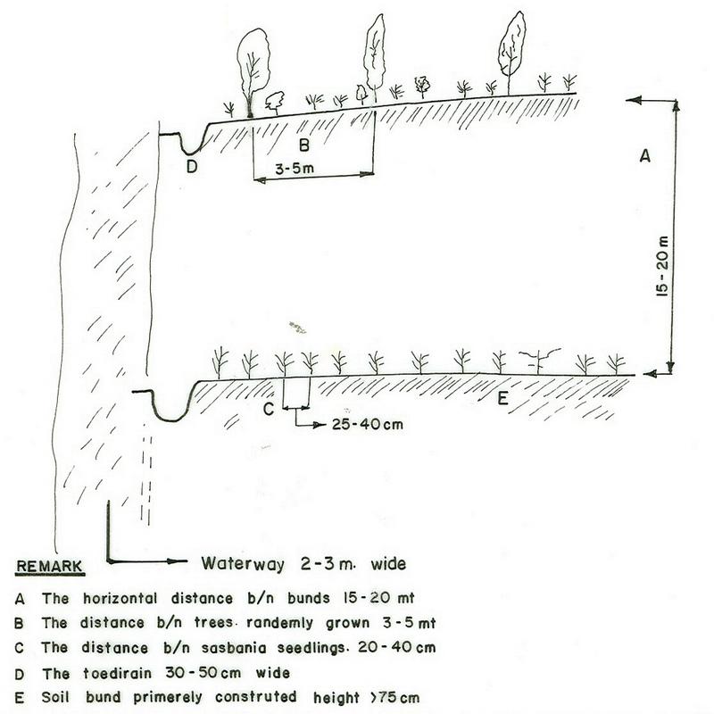
ข้อมูลจำเพาะด้านเทคนิค (แบบแปลนทางเทคนิคของเทคโนโลยี):
Amhara
Technical knowledge required for field staff / advisors: high
Technical knowledge required for land users: moderate
Main technical functions: control of concentrated runoff: retain / trap
Secondary technical functions: improvement of ground cover, increase / maintain water stored in soil, water harvesting / increase water supply
Better crop cover
Material/ species: teff, wheat
Remarks: broad casting
Relay cropping
Material/ species: vetch
Remarks: broad casting
Contour planting / strip cropping
Material/ species: maize
Remarks: 40cm between rows & 20 cm between plants
Agronomic measure: removing less vegetation cover
Material/ species: wheat
Quantity/ density: 40%
Remarks: broad casting
Manure / compost / residues
Material/ species: cow dung, compost
Mineral (inorganic) fertilizers
Material/ species: DAP, UREA
Remarks: 1 qt. DAP & 0.5 qt UREA
Rotations / fallows
Material/ species: on grass lands
Remarks: at least 1 year rotation
Contour ridging
Remarks: using BBM
Aligned: -graded strips
Vegetative material: T : trees / shrubs
Number of plants per (ha): 4000
Vertical interval between rows / strips / blocks (m): 1
Spacing between rows / strips / blocks (m): 20
Vertical interval within rows / strips / blocks (m): 0.25
Width within rows / strips / blocks (m): 0.5
Scattered / dispersed
Vegetative material: T : trees / shrubs
Number of plants per (ha): 10000
Spacing between rows / strips / blocks (m): 1
Vertical interval within rows / strips / blocks (m): 1
Width within rows / strips / blocks (m): 1
Trees/ shrubs species: acacia, saligna,
Fruit trees / shrubs species: mango, guava, papaya
Perennial crops species: coffee
Grass species: local grasses, vetiver, elephant grass
Slope (which determines the spacing indicated above): 6.00%
If the original slope has changed as a result of the Technology, the slope today is (see figure below): 4.00%
Gradient along the rows / strips: 1.00%
Waterway
Spacing between structures (m): 200
Depth of ditches/pits/dams (m): 0.7
Width of ditches/pits/dams (m): 3
Length of ditches/pits/dams (m): 500
Height of bunds/banks/others (m): 0.8
Width of bunds/banks/others (m): 1
Length of bunds/banks/others (m): 500
Bund/ bank: graded
Vertical interval between structures (m): 1-2.5
Spacing between structures (m): 20
Depth of ditches/pits/dams (m): 0.3
Width of ditches/pits/dams (m): 0.5
Length of ditches/pits/dams (m): 150
Height of bunds/banks/others (m): 0.75
Width of bunds/banks/others (m): 1
Length of bunds/banks/others (m): 150
Structural measure: diversion ditch / cut-off drain
Vertical interval between structures (m): 50
Spacing between structures (m): 500
Depth of ditches/pits/dams (m): 0.5
Width of ditches/pits/dams (m): 1
Length of ditches/pits/dams (m): 250
Height of bunds/banks/others (m): 0.8
Width of bunds/banks/others (m): 1
Length of bunds/banks/others (m): 250
Construction material (earth): soil dug out from the ditches and piled as embankment
Construction material (stone): stone is used for paving the water ways
Construction material (wood): used for constructing checkdams
Slope (which determines the spacing indicated above): 6%
If the original slope has changed as a result of the Technology, the slope today is: 4%
Lateral gradient along the structure: 1%
Vegetation is used for stabilisation of structures.
Other type of management: change of management / intensity level - protect the structure from breaching.
4.2 ข้อมูลทั่วไปเกี่ยวกับการคำนวณปัจจัยนำเข้าและค่าใช้จ่าย
อื่นๆ หรือสกุลเงินประจำชาติ (ระบุ):
Birr
If relevant, indicate exchange rate from USD to local currency (e.g. 1 USD = 79.9 Brazilian Real): 1 USD =:
8.6
ระบุค่าเฉลี่ยของค่าจ้างในการจ้างแรงงานต่อวัน:
0.56
4.3 กิจกรรมเพื่อการจัดตั้ง
| กิจกรรม | Timing (season) | |
|---|---|---|
| 1. | cultivation/weeding | |
| 2. | collecting seedlings/seed | onset of rain |
| 3. | transplanting/sowing on bunds | rainy season |
| 4. | survey the line of embankment | dry season |
| 5. | construct bunds, cutoff drai and waterways | dry season |
| 6. | planting the structures | rainy season |
4.4 ค่าใช้จ่ายของปัจจัยนำเข้าที่จำเป็นสำหรับการจัดตั้ง
| ปัจจัยนำเข้า | หน่วย | ปริมาณ | ค่าใช้จ่ายต่อหน่วย | ค่าใช้จ่ายทั้งหมดต่อปัจจัยนำเข้า | %ของค่าใช้จ่ายที่ก่อให้เกิดขึ้นโดยผู้ใช้ที่ดิน | |
|---|---|---|---|---|---|---|
| แรงงาน | Labour | ha | 1.0 | 99.0 | 99.0 | 100.0 |
| อุปกรณ์ | Animal traction | ha | 1.0 | 37.0 | 37.0 | 100.0 |
| วัสดุด้านพืช | Seeds | ha | 1.0 | 12.0 | 12.0 | 100.0 |
| ปุ๋ยและสารฆ่า/ยับยั้งการเจริญเติบโตของสิ่งมีชีวิต (ไบโอไซด์) | Fertilizer | ha | 1.0 | 55.0 | 55.0 | 100.0 |
| ค่าใช้จ่ายทั้งหมดของการจัดตั้งเทคโนโลยี | 203.0 | |||||
| Total costs for establishment of the Technology in USD | 23.6 | |||||
แสดงความคิดเห็น:
Duration of establishment phase: 24 month(s)
4.5 การบำรุงรักษาสภาพหรือกิจกรรมที่เกิดขึ้นเป็นประจำ
| กิจกรรม | ช่วงระยะเวลา/ความถี่ | |
|---|---|---|
| 1. | minimum tillage | during planting / each cropping season |
| 2. | contour tillage | dry season / each cropping season |
| 3. | relay cropping | after 1st harvest / each cropping season |
| 4. | manuring | after 1st plough / each cropping season |
| 5. | mineral fertilizer | during sowing / each cropping season |
| 6. | fencing | during harvesting /once |
| 7. | replanting | rainy season / |
| 8. | pollarding | before raining / |
| 9. | clearing the ditches | onset of rain/as required |
| 10. | strengthning (maintain) the embankment | onset of rain/as required |
| 11. | improve vegetative cover | rainy season/ |
4.6 ค่าใช้จ่ายของปัจจัยนำเข้าและกิจกรรมที่เกิดขึ้นเป็นประจำที่ต้องการการบำรุงรักษา (ต่อปี)
| ปัจจัยนำเข้า | หน่วย | ปริมาณ | ค่าใช้จ่ายต่อหน่วย | ค่าใช้จ่ายทั้งหมดต่อปัจจัยนำเข้า | %ของค่าใช้จ่ายที่ก่อให้เกิดขึ้นโดยผู้ใช้ที่ดิน | |
|---|---|---|---|---|---|---|
| แรงงาน | Labour | ha | 1.0 | 54.0 | 54.0 | 100.0 |
| อุปกรณ์ | Animal traction | ha | 1.0 | 34.0 | 34.0 | 100.0 |
| วัสดุด้านพืช | Seeds | ha | 1.0 | 12.0 | 12.0 | 100.0 |
| ปุ๋ยและสารฆ่า/ยับยั้งการเจริญเติบโตของสิ่งมีชีวิต (ไบโอไซด์) | Fertilizer | ha | 1.0 | 55.0 | 55.0 | 100.0 |
| ค่าใช้จ่ายทั้งหมดของการบำรุงรักษาสภาพเทคโนโลยี | 155.0 | |||||
| Total costs for maintenance of the Technology in USD | 18.02 | |||||
แสดงความคิดเห็น:
The calculation is for 1 ha land in SWC area, where the first year construction of SWC technology with normal cropping (Teff) production and recurrent cost is calculated for the second year for the same plot of land and production system.
4.7 ปัจจัยสำคัญที่สุดที่มีผลกระทบต่อค่าใช้จ่าย
ปัจจัยสำคัญที่สุดที่มีผลกระทบต่อค่าใช้จ่ายต่างๆ:
labour, slope
5. สิ่งแวดล้อมทางธรรมชาติและของมนุษย์
5.1 ภูมิอากาศ
ฝนประจำปี
- < 250 ม.ม.
- 251-500 ม.ม.
- 501-750 ม.ม.
- 751-1,000 ม.ม.
- 1,001-1,500 ม.ม.
- 1,501-2,000 ม.ม.
- 2,001-3,000 ม.ม.
- 3,001-4,000 ม.ม.
- > 4,000 ม.ม.
ข้อมูลจำเพาะ/ความคิดเห็นเรื่องปริมาณน้ำฝน:
1001-1500 mm (ranked 1, around 1100 mm)
751-1000 mm (ranked 2, low areas)
เขตภูมิอากาศเกษตร
- กึ่งชุ่มชื้น
some crops have LGP >270
5.2 สภาพภูมิประเทศ
ค่าเฉลี่ยความลาดชัน:
- ราบเรียบ (0-2%)
- ลาดที่ไม่ชัน (3-5%)
- ปานกลาง (6-10%)
- เป็นลูกคลื่น (11-15%)
- เป็นเนิน (16-30%)
- ชัน (31-60%)
- ชันมาก (>60%)
ธรณีสัณฐาน:
- ที่ราบสูง/ที่ราบ
- สันเขา
- ไหล่เขา
- ไหล่เนินเขา
- ตีนเนิน
- หุบเขา
ระดับความสูง:
- 0-100 เมตร
- 101-500 เมตร
- 501-1,000 เมตร
- 1,001-1,500 เมตร
- 1,501-2,000 เมตร
- 2,001-2,500 เมตร
- 2,501-3,000 เมตร
- 3,001-4,000 เมตร
- > 4,000 เมตร
ความคิดเห็นและข้อมูลจำเพาะเพิ่มเติมเรื่องสภาพภูมิประเทศ:
Altitudinal zone: 2001-2500 m a.s.l. (The SWC area is within this range)
Slopes on average: Also moderate (ranked 2) and hilly (ranked 3)
5.3 ดิน
ค่าเฉลี่ยความลึกของดิน:
- ตื้นมาก (0-20 ซ.ม.)
- ตื้น (21-50 ซ.ม.)
- ลึกปานกลาง (51-80 ซ.ม.)
- ลึก (81-120 ซ.ม.)
- ลึกมาก (>120 ซ.ม.)
เนื้อดิน (ดินชั้นบน):
- ปานกลาง (ดินร่วน ทรายแป้ง)
- ละเอียด/หนัก (ดินเหนียว)
(ถ้ามี) ให้แนบคำอธิบายเรื่องดินแบบเต็มหรือระบุข้อมูลที่มีอยู่ เช่น ชนิดของดิน ค่า pH ของดินหรือความเป็นกรดของดิน ความสามารถในการแลกเปลี่ยนประจุบวก ไนโตรเจน ความเค็ม เป็นต้น:
Soil depth on average: Also deep (ranked 2) and shallow (ranked 3)
Soil texture: Medium (ranked 1, major component is clay loam) and fine/heavy (ranked 2)
Soil fertility: Medium (ranked 1, use of chemical fertilizer is increasing every year), low (ranked 2) and very low (ranked 3)
Soil drainage/infiltration: Medium (ranked 1), poor (ranked 2) and good (ranked 3)
Soil water storage capacity: High (ranked 1), low (ranked 2, ground water level is decreasing every year) and very low (ranked 3)
5.6 ลักษณะของผู้ใช้ที่ดินที่นำเทคโนโลยีไปปฏิบัติใช้
แนวทางการตลาดของระบบการผลิต:
- เพื่อการยังชีพ (หาเลี้ยงตนเอง)
- mixed (subsistence/ commercial)
รายได้ที่มาจากนอกฟาร์ม:
- < 10% ของรายได้ทั้งหมด
ระดับของความมั่งคั่งโดยเปรียบเทียบ:
- จน
- พอมีพอกิน
ระดับของการใช้เครื่องจักรกล:
- งานที่ใช้แรงกาย
- การใช้กำลังจากสัตว์
ระบุลักษณะอื่นๆที่เกี่ยวข้องของผู้ใช้ที่ดิน:
Population density: 200-500 persons/km2
Annual population growth: 2% - 3%
35% of the land users are average wealthy and own 40% of the land (they take care of their land).
40% of the land users are poor and own 35% of the land (they construct SWC but no follow up).
25% of the land users are poor and own 25% of the land (some times they rent out their land for others).
Off-farm income specification: Farmers have so far not been engaged in any type off-farm activites in the area.
Level of mechanization: Animal traction (ranked 1, local plough) and manual work (ranked 2)
Marekt orientation: Subsistence (ranked 1) and mixed (ranked 2, some crops and livestock products)
5.7 Average area of land used by land users applying the Technology
- < 0.5 เฮกตาร์
- 0.5-1 เฮกตาร์
- 1-2 เฮกตาร์
- 2-5 เฮกตาร์
- 5-15 เฮกตาร์
- 15-50 เฮกตาร์
- 50-100 เฮกตาร์
- 100-500 เฮกตาร์
- 500-1,000 เฮกตาร์
- 1,000-10,000 เฮกตาร์
- >10,000 เฮกตาร์
แสดงความคิดเห็น:
0.5-1 ha: Most of the young generation are classified under this category. Also grazing land is converted to cultivation
5.8 กรรมสิทธิ์ในที่ดิน สิทธิในการใช้ที่ดินและสิทธิในการใช้น้ำ
กรรมสิทธิ์ในที่ดิน:
- รัฐ
สิทธิในการใช้ที่ดิน:
- รายบุคคล
6. ผลกระทบและสรุปคำบอกกล่าว
6.1 ผลกระทบในพื้นที่ดำเนินการ (On-site) จากการใช้เทคโนโลยี
ผลกระทบทางด้านเศรษฐกิจและสังคม
การผลิต
การผลิตพืชผล
การผลิตพืชที่ใช้เลี้ยงปศุสัตว์
คุณภาพพืชที่ใช้เลี้ยงปศุสัตว์
การผลิตไม้
พื้นที่สำหรับการผลิต
แสดงความคิดเห็น/ระบุ:
especially for the first 1-2 years
การจัดการที่ดิน
แสดงความคิดเห็น/ระบุ:
lack of consulting the farmer
รายได้และค่าใช้จ่าย
รายได้จากฟาร์ม
ผลกระทบด้านสังคมวัฒนธรรมอื่น ๆ
สถาบันของชุมชน
SLM หรือความรู้เรื่องความเสื่อมโทรมของที่ดิน
Land border security
แสดงความคิดเห็น/ระบุ:
Bunds are baundary of farm plots
ผลกระทบด้านนิเวศวิทยา
วัฐจักรน้ำหรือน้ำบ่า
น้ำไหลบ่าที่ผิวดิน
จำนวนก่อน SLM:
50
หลังจาก SLM:
30
การระบายน้ำส่วนเกิน
ดิน
ความชื้นในดิน
สิ่งปกคลุมดิน
การสูญเสียดิน
แสดงความคิดเห็น/ระบุ:
Unless improper design
อินทรียวัตถุในดิน/ต่ำกว่าดินชั้น C
ผลกระทบด้านนิเวศวิทยาอื่น ๆ
Soil fertility
Biodiversity
6.2 ผลกระทบนอกพื้นที่ดำเนินการ (Off-site) จากการใช้เทคโนโลยี
น้ำท่วมพื้นที่ท้ายน้ำ
การเกิดมลพิษในน้ำบาดาลหรือแม่น้ำ
ตะกอนที่ถูกพัดพามาโดยลม
6.4 การวิเคราะห์ค่าใช้จ่ายและผลประโยชน์ที่ได้รับ
ผลประโยชน์ที่ได้รับเปรียบเทียบกับค่าใช้จ่ายในการจัดตั้งเป็นอย่างไร (จากมุมมองของผู้ใช้ที่ดิน)
ผลตอบแทนระยะสั้น:
ด้านบวกเล็กน้อย
ผลตอบแทนระยะยาว:
ด้านบวกอย่างมาก
ผลประโยชน์ที่ได้รับเปรียบเทียบกับค่าใช้จ่ายในการบำรุงรักษาหรือต้นทุนที่เกิดขึ้นซ้ำอีก เป็นอย่างไร (จากมุมมองของผู้ใช้ที่ดิน)
ผลตอบแทนระยะสั้น:
ด้านบวก
ผลตอบแทนระยะยาว:
ด้านบวกอย่างมาก
6.5 การปรับตัวของเทคโนโลยี
แสดงความคิดเห็น:
Comments on acceptance with external material support: estimates
100% of land user families have adopted the Technology without any external material support
Comments on spontaneous adoption: survey results
There is a moderate trend towards spontaneous adoption of the Technology
Comments on adoption trend: In the SWC area more than 75% of the households adopted the technology. They include stone walls to reinforce soil bunds. Stone walls have the disadvantage of harbouring rodents and hence soil bunds are preferred.
6.7 จุดแข็ง / ข้อได้เปรียบ / โอกาสของเทคโนโลยี
| จุดแข็ง / ข้อได้เปรียบ / โอกาสในทัศนคติของผู้ใช้ที่ดิน |
|---|
| protect the land from soil erosion |
| จุดแข็ง / ข้อได้เปรียบ / โอกาสในทัศนคติของผู้รวบรวมหรือวิทยากรหลัก |
|---|
|
control loss of top soil and water and enhances sustainable production. How can they be sustained / enhanced? proper layout, integrated with other techniques and modification based on farmers intersts. |
| suficient soil moisture retention in the lower altitudes. |
6.8 จุดอ่อน / ข้อเสียเปรียบ / ความเสี่ยงของเทคโนโลยีและวิธีการแก้ไข
| จุดอ่อน / ข้อเสียเปรียบ / ความเสี่ยงในทัศนคติของผู้ใช้ที่ดิน | มีวิธีการแก้ไขได้อย่างไร |
|---|---|
| closer bunds are obstacle for farm operation | modify based on farming system local conditions |
| loss of land | make the bund productive |
| rodent and pest | provision of approprate measures |
| runner grass | proper management of the land |
| จุดอ่อน / ข้อเสียเปรียบ / ความเสี่ยงในทัศนคติของผู้รวบรวมหรือวิทยากรหลัก | มีวิธีการแก้ไขได้อย่างไร |
|---|---|
| area occupied by bund | increase the productivity of land per unit area by planting fruit tree, forage plants on the bund |
7. การอ้างอิงและการเชื่อมต่อ
7.1 วิธีการและแหล่งข้อมูล
ลิงก์และโมดูล
ขยายทั้งหมด ย่อทั้งหมดลิงก์
ไม่มีลิงก์
โมดูล
ไม่มีโมดูล