Stablized Stone Faced Soil Bund [เอธิโอเปีย]
- ผู้สร้างสรรค์:
- การอัพเดท:
- ผู้รวบรวม: Unknown User
- ผู้เรียบเรียง: –
- ผู้ตรวจสอบ: Fabian Ottiger, Alexandra Gavilano
Kirit (Amharic)
technologies_1063 - เอธิโอเปีย
ดูส่วนย่อย
ขยายทั้งหมด ย่อทั้งหมด1. ข้อมูลทั่วไป
1.2 รายละเอียดที่ติดต่อได้ของผู้รวบรวมและองค์กรที่เกี่ยวข้องในการประเมินและการจัดเตรียมทำเอกสารของเทคโนโลยี
วิทยากรหลัก
ผู้เชี่ยวชาญ SLM:
Abegaz Ayalew Yimer
Ambassel Woreda Agriculture and Rural Development Office
เอธิโอเปีย
ชื่อขององค์กรซึ่งอำนวยความสะดวกในการทำเอกสารหรือการประเมินเทคโนโลยี (ถ้าเกี่ยวข้อง)
Ministry of Agriculture and Rural Development (Ministry of Agriculture and Rural Development) - เอธิโอเปีย1.3 เงื่อนไขการใช้ข้อมูลที่ได้บันทึกผ่านทาง WOCAT
ผู้รวบรวมและวิทยากรหลักยอมรับเงื่อนไขเกี่ยวกับการใช้ข้อมูลที่ถูกบันทึกผ่านทาง WOCAT:
ใช่
1.5 Reference to Questionnaire(s) on SLM Approaches (documented using WOCAT)

Local Level participatory planning approach (LLPPA) [เอธิโอเปีย]
Participatory planning tools using various PRA techniques to enable the local community to identif their problem prioritize to sellect suitable measures & activities (planing, implementing & mgt of conservation based initiatives.
- ผู้รวบรวม: Philippe Zahner
2. การอธิบายลักษณะของเทคโนโลยี SLM
2.1 การอธิบายแบบสั้น ๆ ของเทคโนโลยี
คำจำกัดความของเทคโนโลยี:
Stablized bund constructed fron stone and soils on the farm land along the contour and planted with multipurposive plant species
2.2 การอธิบายแบบละเอียดของเทคโนโลยี
คำอธิบาย:
The stablized bund is constructed on farm land in order to reduce slope length, angle and there by control soil erosion and enhance moisture/water retention capacity of siols. The bund is established along the contour by digging trench/foundation and place stone walls on the excavated trench. It is stablized by planting grass. The structure is regularly maintained by repairing breaks. Some farmers put on additional height to the bunds as part of the upgrading practice. The technology is suitable to all agroecological conditions, where stones are available for construction.
2.5 ประเทศภูมิภาค หรือสถานที่ตั้งที่เทคโนโลยีได้นำไปใช้และได้รับการครอบคลุมโดยการประเมินนี้
ประเทศ:
เอธิโอเปีย
ภูมิภาค/รัฐ/จังหวัด:
Amhara
ข้อมูลจำเพาะเพิ่มเติมของสถานที่ตั้ง :
Ambassel
ระบุการกระจายตัวของเทคโนโลยี:
- กระจายไปอย่างสม่ำเสมอในพื้นที่
If precise area is not known, indicate approximate area covered:
- 10-100 ตร.กม.
แสดงความคิดเห็น:
Since the implementation of this technology flooding problem has reduced with additional benefit of protecting roads. Communies benefited from ffw payments and activities, production of farm land improved (both crop & fodder)
Map
×2.6 วันที่การดำเนินการ
ถ้าไม่รู้ปีที่แน่นอน ให้ระบุวันที่โดยประมาณ:
- มากกว่า 50 ปี (แบบดั้งเดิม)
2.7 คำแนะนำของเทคโนโลยี
ให้ระบุว่าเทคโนโลยีถูกแนะนำเข้ามาอย่างไร:
- ทางโครงการหรือจากภายนอก
ความคิดเห็น (ประเภทของโครงการ เป็นต้น) :
It is locally known but with improved techniques. Stone walls are used in the area for making barriers for runoff.
3. การจัดประเภทของเทคโนโลยี SLM
3.1 วัตถุประสงค์หลักของเทคโนโลยี
- ลด ป้องกัน ฟื้นฟู การเสื่อมโทรมของที่ดิน
3.2 ประเภทของการใช้ที่ดินในปัจจุบันที่ได้นำเทคโนโลยีไปใช้
Land use mixed within the same land unit:
ใช่
Specify mixed land use (crops/ grazing/ trees):
- วนเกษตร (Agroforestry)

พื้นที่ปลูกพืช
- การปลูกพืชล้มลุกอายุปีเดียว
- การปลูกไม้ยืนต้น ไม้พุ่ม
Annual cropping - Specify crops:
- cereals - barley
- cereals - maize
- cereals - sorghum
- legumes and pulses - beans
- legumes and pulses - peas
- wheat, teff
Tree and shrub cropping - Specify crops:
- fodder trees (Calliandra, Leucaena leucocephala, Prosopis, etc.)
จำนวนของฤดูเพาะปลูกต่อปี:
- 2
ระบุ:
Longest growing period in days: 24 0Longest growing period from month to month: May - Dec Second longest growing period in days: 150 Second longest growing period from month to month: Feb - Jun
แสดงความคิดเห็น:
Major food crop annual cropping: Sorghum, maize, teff, wheat, barley, beans, peas
Trees/ shrubs species: pigeon pea, sesbania sesban, treelucern (Fabaceae)
Major land use problems (compiler’s opinion): Soil erosion, overgrazing, deforestation, encrochment of one type of landuse over the other (competetion between landuse types)
Major land use problems (land users’ perception): declining production, shallow soil depth, infestation of weeds (exotic)
Type of cropping system and major crops comments: Sorghum-teff, maize-beans, teff-check peas, wheat/barley-legumes
3.4 การใช้น้ำ
การใช้น้ำของที่ดินที่มีการใช้เทคโนโลยีอยู่:
- จากน้ำฝน
แสดงความคิดเห็น:
Water supply: Also mixed rainfed - irrigated
3.5 กลุ่ม SLM ที่ตรงกับเทคโนโลยีนี้
- มาตรการปลูกพืชขวางความลาดชัน (cross-slope measure)
3.6 มาตรการ SLM ที่ประกอบกันเป็นเทคโนโลยี
3.7 รูปแบบหลักของการเสื่อมโทรมของที่ดินที่ได้รับการแก้ไขโดยเทคโนโลยี

การกัดกร่อนของดินโดยน้ำ
- Wt (Loss of topsoil): การสูญเสียดินชั้นบนหรือการกัดกร่อนที่ผิวดิน
- Wg (Gully erosion): การกัดกร่อนแบบร่องธารหรือการทำให้เกิดร่องน้ำเซาะ
- Wm (Mass movement): การเคลื่อนตัวของมวลดินหรือดินถล่ม

การเสื่อมโทรมของดินทางด้านเคมี
- Cn (Fertility decline): ความอุดมสมบูรณ์และปริมาณอินทรียวัตถุในดินถูกทำให้ลดลงไป (ไม่ได้เกิดจากสาเหตุการกัดกร่อน)
แสดงความคิดเห็น:
Main type of degradation addressed: Wt: loss of topsoil / surface erosion
Secondary types of degradation addressed: Wg: gully erosion / gullying, Wm: mass movements / landslides, Cn: fertility decline and reduced organic matter content
3.8 การป้องกัน การลดลง หรือการฟื้นฟูความเสื่อมโทรมของที่ดิน
ระบุเป้าหมายของเทคโนโลยีกับความเสื่อมโทรมของที่ดิน:
- ลดความเสื่อมโทรมของดิน
แสดงความคิดเห็น:
Secondary goals: prevention of land degradation, rehabilitation / reclamation of denuded land
4. ข้อมูลจำเพาะด้านเทคนิค กิจกรรมการนำไปปฏิบัติใช้ ปัจจัยนำเข้า และค่าใช้จ่าย
4.1 แบบแปลนทางเทคนิคของเทคโนโลยี
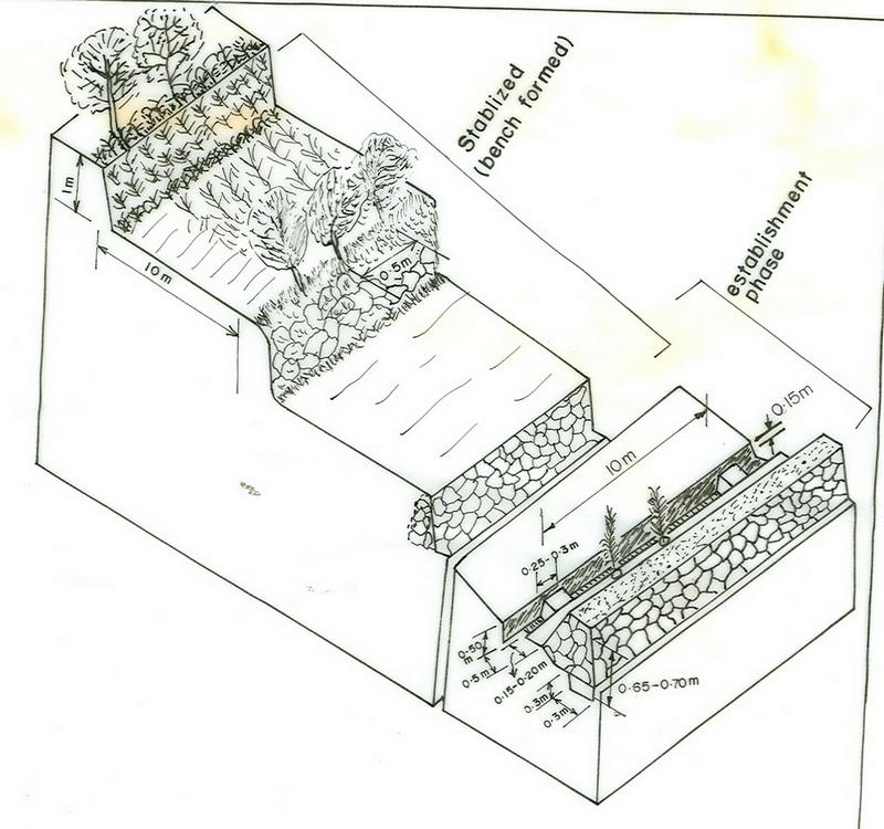
ข้อมูลจำเพาะด้านเทคนิค (แบบแปลนทางเทคนิคของเทคโนโลยี):
Amhara
Technical knowledge required for field staff / advisors: moderate
Technical knowledge required for land users: moderate
Main technical functions: reduction of slope angle, reduction of slope length
Secondary technical functions: control of dispersed runoff: retain / trap, control of dispersed runoff: impede / retard, increase of infiltration, increase / maintain water stored in soil, water harvesting / increase water supply
Aligned: -contour
Vertical interval between rows / strips / blocks (m): 1m
Spacing between rows / strips / blocks (m): 10m
Vertical interval within rows / strips / blocks (m): 0.25-0.5m
Trees/ shrubs species: pigeon pea, sesbania sesban, treelucern
Bund/ bank: level
Vertical interval between structures (m): 1m
Spacing between structures (m): 10m
Depth of ditches/pits/dams (m): 0.5m
Width of ditches/pits/dams (m): 0.5m
Length of ditches/pits/dams (m): 166m
Height of bunds/banks/others (m): 0.7m
Width of bunds/banks/others (m): 0.5-1.20m
Length of bunds/banks/others (m): 170m
Construction material (earth): dig earth and form an embankment
Construction material (stone): place stone wall at downslope side to support earth embankment
Slope (which determines the spacing indicated above): 12%
If the original slope has changed as a result of the Technology, the slope today is: 0%
Lateral gradient along the structure: 0%
Vegetation is used for stabilisation of structures.
4.2 ข้อมูลทั่วไปเกี่ยวกับการคำนวณปัจจัยนำเข้าและค่าใช้จ่าย
อื่นๆ หรือสกุลเงินประจำชาติ (ระบุ):
Birr
If relevant, indicate exchange rate from USD to local currency (e.g. 1 USD = 79.9 Brazilian Real): 1 USD =:
8.6
ระบุค่าเฉลี่ยของค่าจ้างในการจ้างแรงงานต่อวัน:
0.70
4.3 กิจกรรมเพื่อการจัดตั้ง
| กิจกรรม | Timing (season) | |
|---|---|---|
| 1. | contour tillage | uly/during crop sowing |
| 2. | contour planting | July/during crop sowing |
| 3. | collection of stones | dry season/off-season |
| 4. | layout and design | dry season/off-season |
| 5. | excavation of foundation & trenches | dry season/off-season |
| 6. | forming of embankment | dry season/off-season |
| 7. | compaction | dry season/off-season |
| 8. | sow/plant tree/grass species | onset of rain |
4.4 ค่าใช้จ่ายของปัจจัยนำเข้าที่จำเป็นสำหรับการจัดตั้ง
| ปัจจัยนำเข้า | หน่วย | ปริมาณ | ค่าใช้จ่ายต่อหน่วย | ค่าใช้จ่ายทั้งหมดต่อปัจจัยนำเข้า | %ของค่าใช้จ่ายที่ก่อให้เกิดขึ้นโดยผู้ใช้ที่ดิน | |
|---|---|---|---|---|---|---|
| แรงงาน | Labour | ha | 1.0 | 170.0 | 170.0 | |
| แรงงาน | Weeding | ha | 1.0 | 47.0 | 47.0 | 100.0 |
| แรงงาน | Harvesting | ha | 1.0 | 23.0 | 23.0 | 100.0 |
| อุปกรณ์ | Animal traction | ha | 1.0 | 35.0 | 35.0 | 100.0 |
| อุปกรณ์ | Tools | ha | 1.0 | 720.0 | 720.0 | |
| วัสดุด้านพืช | Seeds | ha | 1.0 | 7.0 | 7.0 | |
| วัสดุด้านพืช | Seedlings | ha | 1.0 | 23.0 | 23.0 | 100.0 |
| ปุ๋ยและสารฆ่า/ยับยั้งการเจริญเติบโตของสิ่งมีชีวิต (ไบโอไซด์) | Fertilizer | ha | 1.0 | 54.0 | 54.0 | 100.0 |
| ค่าใช้จ่ายทั้งหมดของการจัดตั้งเทคโนโลยี | 1079.0 | |||||
| Total costs for establishment of the Technology in USD | 125.47 | |||||
แสดงความคิดเห็น:
Duration of establishment phase: 12 month(s)
4.5 การบำรุงรักษาสภาพหรือกิจกรรมที่เกิดขึ้นเป็นประจำ
| กิจกรรม | ช่วงระยะเวลา/ความถี่ | |
|---|---|---|
| 1. | contour farming | before rain & onset of rain / 3 times/year |
| 2. | removing of silt from the trench | off season/once per year |
| 3. | maintain broken part of the bund | off season/once per year |
| 4. | replanting | on set of rain/once per year |
4.6 ค่าใช้จ่ายของปัจจัยนำเข้าและกิจกรรมที่เกิดขึ้นเป็นประจำที่ต้องการการบำรุงรักษา (ต่อปี)
| ปัจจัยนำเข้า | หน่วย | ปริมาณ | ค่าใช้จ่ายต่อหน่วย | ค่าใช้จ่ายทั้งหมดต่อปัจจัยนำเข้า | %ของค่าใช้จ่ายที่ก่อให้เกิดขึ้นโดยผู้ใช้ที่ดิน | |
|---|---|---|---|---|---|---|
| แรงงาน | Labour | ha | 1.0 | 17.0 | 17.0 | 100.0 |
| อุปกรณ์ | Tools | ha | 1.0 | 72.0 | 72.0 | |
| ค่าใช้จ่ายทั้งหมดของการบำรุงรักษาสภาพเทคโนโลยี | 89.0 | |||||
| Total costs for maintenance of the Technology in USD | 10.35 | |||||
แสดงความคิดเห็น:
Machinery/ tools: shovel, spade, hoe, line level
Length of structure per hectare of land treated with SWC activities
4.7 ปัจจัยสำคัญที่สุดที่มีผลกระทบต่อค่าใช้จ่าย
ปัจจัยสำคัญที่สุดที่มีผลกระทบต่อค่าใช้จ่ายต่างๆ:
The cost of the technology is affected by slope, soil workability, availability of labour
5. สิ่งแวดล้อมทางธรรมชาติและของมนุษย์
5.1 ภูมิอากาศ
ฝนประจำปี
- < 250 ม.ม.
- 251-500 ม.ม.
- 501-750 ม.ม.
- 751-1,000 ม.ม.
- 1,001-1,500 ม.ม.
- 1,501-2,000 ม.ม.
- 2,001-3,000 ม.ม.
- 3,001-4,000 ม.ม.
- > 4,000 ม.ม.
เขตภูมิอากาศเกษตร
- กึ่งชุ่มชื้น
- กึ่งแห้งแล้ง
5.2 สภาพภูมิประเทศ
ค่าเฉลี่ยความลาดชัน:
- ราบเรียบ (0-2%)
- ลาดที่ไม่ชัน (3-5%)
- ปานกลาง (6-10%)
- เป็นลูกคลื่น (11-15%)
- เป็นเนิน (16-30%)
- ชัน (31-60%)
- ชันมาก (>60%)
ธรณีสัณฐาน:
- ที่ราบสูง/ที่ราบ
- สันเขา
- ไหล่เขา
- ไหล่เนินเขา
- ตีนเนิน
- หุบเขา
ระดับความสูง:
- 0-100 เมตร
- 101-500 เมตร
- 501-1,000 เมตร
- 1,001-1,500 เมตร
- 1,501-2,000 เมตร
- 2,001-2,500 เมตร
- 2,501-3,000 เมตร
- 3,001-4,000 เมตร
- > 4,000 เมตร
ความคิดเห็นและข้อมูลจำเพาะเพิ่มเติมเรื่องสภาพภูมิประเทศ:
Altitudinal zone: Also 1501-2000 m a.s.l. (ranked 2) and 1001-1500 and 2501-3000 m a.s.l. (ranked 3)
Landforms: Also plateau/plains and hill slopes (both ranked 2) and ridges and foot slopes (both ranked 3)
5.3 ดิน
ค่าเฉลี่ยความลึกของดิน:
- ตื้นมาก (0-20 ซ.ม.)
- ตื้น (21-50 ซ.ม.)
- ลึกปานกลาง (51-80 ซ.ม.)
- ลึก (81-120 ซ.ม.)
- ลึกมาก (>120 ซ.ม.)
เนื้อดิน (ดินชั้นบน):
- หยาบ/เบา (ดินทราย)
- ปานกลาง (ดินร่วน ทรายแป้ง)
อินทรียวัตถุในดิน:
- ปานกลาง (1-3%)
- ต่ำ (<1%)
(ถ้ามี) ให้แนบคำอธิบายเรื่องดินแบบเต็มหรือระบุข้อมูลที่มีอยู่ เช่น ชนิดของดิน ค่า pH ของดินหรือความเป็นกรดของดิน ความสามารถในการแลกเปลี่ยนประจุบวก ไนโตรเจน ความเค็ม เป็นต้น:
Soil depth on average: Also moderately deep and deep (both ranked 2) and very shallow and very deep (both ranked 3)
Soil fertility: Low (ranked 1, on hilly areas), medium (ranked 2), very low and high (both ranked 3)
Soil drainage/infiltration: Good (ranked 1, on hilly and steep slopes), medium (ranked 2) and poor (ranked 3)
Soil water storage capacity: High (ranked 1), medium (ranked 2) and low (ranked 3)
5.6 ลักษณะของผู้ใช้ที่ดินที่นำเทคโนโลยีไปปฏิบัติใช้
แนวทางการตลาดของระบบการผลิต:
- เพื่อการยังชีพ (หาเลี้ยงตนเอง)
รายได้ที่มาจากนอกฟาร์ม:
- < 10% ของรายได้ทั้งหมด
ระดับของความมั่งคั่งโดยเปรียบเทียบ:
- พอมีพอกิน
- รวย
ระดับของการใช้เครื่องจักรกล:
- งานที่ใช้แรงกาย
- การใช้กำลังจากสัตว์
ระบุลักษณะอื่นๆที่เกี่ยวข้องของผู้ใช้ที่ดิน:
Population density: 50-100 persons/km2
Annual population growth: 2% - 3%
5% of the land users are rich and own 10% of the land.
35% of the land users are average wealthy and own 50% of the land.
60% of the land users are poor and own 40% of the land.
5.7 Average area of land used by land users applying the Technology
- < 0.5 เฮกตาร์
- 0.5-1 เฮกตาร์
- 1-2 เฮกตาร์
- 2-5 เฮกตาร์
- 5-15 เฮกตาร์
- 15-50 เฮกตาร์
- 50-100 เฮกตาร์
- 100-500 เฮกตาร์
- 500-1,000 เฮกตาร์
- 1,000-10,000 เฮกตาร์
- >10,000 เฮกตาร์
แสดงความคิดเห็น:
Due to population pressure and land degradation
5.8 กรรมสิทธิ์ในที่ดิน สิทธิในการใช้ที่ดินและสิทธิในการใช้น้ำ
กรรมสิทธิ์ในที่ดิน:
- รัฐ
6. ผลกระทบและสรุปคำบอกกล่าว
6.1 ผลกระทบในพื้นที่ดำเนินการ (On-site) จากการใช้เทคโนโลยี
ผลกระทบทางด้านเศรษฐกิจและสังคม
การผลิต
การผลิตพืชผล
คุณภาพพืชที่ใช้เลี้ยงปศุสัตว์
การผลิตสัตว์
การผลิตไม้
รายได้และค่าใช้จ่าย
รายได้จากฟาร์ม
ผลกระทบด้านสังคมวัฒนธรรมอื่น ๆ
สถาบันของชุมชน
สถาบันแห่งชาติ
SLM หรือความรู้เรื่องความเสื่อมโทรมของที่ดิน
ผลกระทบด้านนิเวศวิทยา
วัฐจักรน้ำหรือน้ำบ่า
น้ำไหลบ่าที่ผิวดิน
จำนวนก่อน SLM:
60
หลังจาก SLM:
10
ดิน
ความชื้นในดิน
แสดงความคิดเห็น/ระบุ:
because of increasing in soil depth it helps to retain moisture.
การสูญเสียดิน
จำนวนก่อน SLM:
2.5
หลังจาก SLM:
0
แสดงความคิดเห็น/ระบุ:
soil depth increased/maintained, decrease slope
ผลกระทบด้านนิเวศวิทยาอื่น ๆ
Soil fertility
Biodiversity
6.2 ผลกระทบนอกพื้นที่ดำเนินการ (Off-site) จากการใช้เทคโนโลยี
การไหลของน้ำคงที่และสม่ำเสมอในช่วงฤดูแล้ง
แสดงความคิดเห็น/ระบุ:
increase percolation of rain water
น้ำท่วมพื้นที่ท้ายน้ำ
แสดงความคิดเห็น/ระบุ:
roads, reserviores, farmlands
การทับถมของดินตะกอนพื้นที่ท้ายน้ำ
6.4 การวิเคราะห์ค่าใช้จ่ายและผลประโยชน์ที่ได้รับ
ผลประโยชน์ที่ได้รับเปรียบเทียบกับค่าใช้จ่ายในการจัดตั้งเป็นอย่างไร (จากมุมมองของผู้ใช้ที่ดิน)
ผลตอบแทนระยะสั้น:
ด้านลบ
ผลตอบแทนระยะยาว:
ด้านบวก
ผลประโยชน์ที่ได้รับเปรียบเทียบกับค่าใช้จ่ายในการบำรุงรักษาหรือต้นทุนที่เกิดขึ้นซ้ำอีก เป็นอย่างไร (จากมุมมองของผู้ใช้ที่ดิน)
ผลตอบแทนระยะสั้น:
ด้านลบ
ผลตอบแทนระยะยาว:
ด้านบวก
6.5 การปรับตัวของเทคโนโลยี
แสดงความคิดเห็น:
100% of land user families have adopted the Technology with external material support
20730 land user families have adopted the Technology with external material support
Comments on acceptance with external material support: estimates
6.7 จุดแข็ง / ข้อได้เปรียบ / โอกาสของเทคโนโลยี
| จุดแข็ง / ข้อได้เปรียบ / โอกาสในทัศนคติของผู้รวบรวมหรือวิทยากรหลัก |
|---|
|
reduce soil loss, improve soil moisture How can they be sustained / enhanced? continuous awarness creation about the technology and its benefit and the required frequent supervision |
|
increase feed and fodder, promote cut and carry system How can they be sustained / enhanced? provision of suitable feed/forage plant species, collection and distribution of seeds |
6.8 จุดอ่อน / ข้อเสียเปรียบ / ความเสี่ยงของเทคโนโลยีและวิธีการแก้ไข
| จุดอ่อน / ข้อเสียเปรียบ / ความเสี่ยงในทัศนคติของผู้ใช้ที่ดิน | มีวิธีการแก้ไขได้อย่างไร |
|---|---|
| loss of land due to land occupation | Increase/improve productivity of fodder trees on bunds and improve farm land production to compensate |
| จุดอ่อน / ข้อเสียเปรียบ / ความเสี่ยงในทัศนคติของผู้รวบรวมหรือวิทยากรหลัก | มีวิธีการแก้ไขได้อย่างไร |
|---|---|
| space between bunds is narrow for oxen plough | proper spacing to be designed/adopted |
| harbour pests | proper management and availing pesticides |
7. การอ้างอิงและการเชื่อมต่อ
7.1 วิธีการและแหล่งข้อมูล
ลิงก์และโมดูล
ขยายทั้งหมด ย่อทั้งหมดลิงก์
Local Level participatory planning approach (LLPPA) [เอธิโอเปีย]
Participatory planning tools using various PRA techniques to enable the local community to identif their problem prioritize to sellect suitable measures & activities (planing, implementing & mgt of conservation based initiatives.
- ผู้รวบรวม: Philippe Zahner
โมดูล
ไม่มีโมดูล