Earth checks for Gully reclamation [เอธิโอเปีย]
- ผู้สร้างสรรค์:
- การอัพเดท:
- ผู้รวบรวม: Daniel Danano
- ผู้เรียบเรียง: –
- ผู้ตรวจสอบ: Fabian Ottiger, Alexandra Gavilano
technologies_1069 - เอธิโอเปีย
ดูส่วนย่อย
ขยายทั้งหมด ย่อทั้งหมด1. ข้อมูลทั่วไป
1.2 รายละเอียดที่ติดต่อได้ของผู้รวบรวมและองค์กรที่เกี่ยวข้องในการประเมินและการจัดเตรียมทำเอกสารของเทคโนโลยี
ผู้เชี่ยวชาญ SLM:
Estifanos Zena
Ministry of Agriculture and Rural Development
เอธิโอเปีย
ผู้เชี่ยวชาญ SLM:
Desta Hiwot
Boditi, Department of Agriculture and Rural Development
เอธิโอเปีย
ชื่อขององค์กรซึ่งอำนวยความสะดวกในการทำเอกสารหรือการประเมินเทคโนโลยี (ถ้าเกี่ยวข้อง)
FAO Food and Agriculture Organization (FAO Food and Agriculture Organization) - อิตาลีชื่อขององค์กรซึ่งอำนวยความสะดวกในการทำเอกสารหรือการประเมินเทคโนโลยี (ถ้าเกี่ยวข้อง)
Ministry of Agriculture and Rural Development (Ministry of Agriculture and Rural Development) - เอธิโอเปีย1.3 เงื่อนไขการใช้ข้อมูลที่ได้บันทึกผ่านทาง WOCAT
ผู้รวบรวมและวิทยากรหลักยอมรับเงื่อนไขเกี่ยวกับการใช้ข้อมูลที่ถูกบันทึกผ่านทาง WOCAT:
ใช่
2. การอธิบายลักษณะของเทคโนโลยี SLM
2.1 การอธิบายแบบสั้น ๆ ของเทคโนโลยี
คำจำกัดความของเทคโนโลยี:
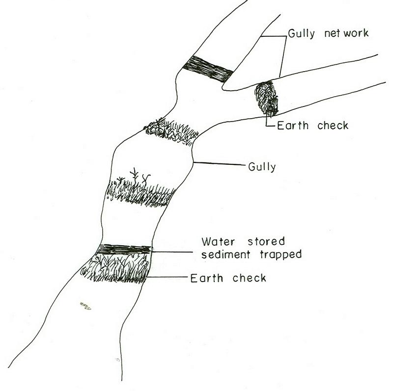
Earh-checks are constructed of earth embankment put across in a deep gully in such a way to trap sediment and store water passing by it.
2.2 การอธิบายแบบละเอียดของเทคโนโลยี
คำอธิบาย:
Active deep gullies are plugged by digging earth from the bottom as well as gully sides and embanked forming a barrier to runoff passing through it. The embankment is reinforced by planting useful plants such as banana, sesbania, gravillea, gesho, etc., The purpose is to rehabilitate gullies having depth and expand along sides and towards the head. By constructing earth checks the water is stored in the checks. The water percolates down the ground enriching the ground water. The soil is trapped in the checks and later brings up the gully gradient higher. As a result, a cultivable/cropable strip is formed. Weeding and cultivation done to plants established.The gully fence and breaks are repaired. The technology is seen to be suitable to humid highlands where land loss by gully is a serious problem and land under cultivation and grazing is getting here and there. In brief it is suitable in areas where land degradation problem is increasing with currently cultivated and grazed lands are encroched by gully expansion.
2.3 รูปภาพของเทคโนโลยี
อัลบั้มสื่อบันทึก
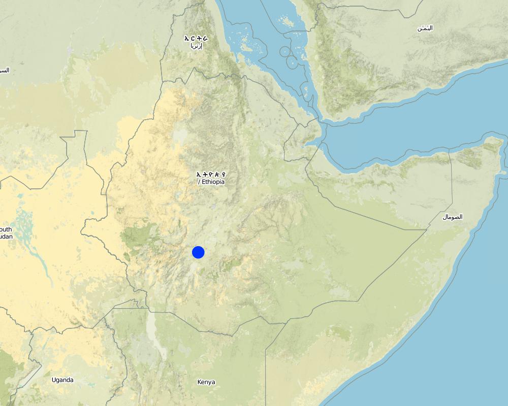
2.5 ประเทศภูมิภาค หรือสถานที่ตั้งที่เทคโนโลยีได้นำไปใช้และได้รับการครอบคลุมโดยการประเมินนี้
ประเทศ:
เอธิโอเปีย
ภูมิภาค/รัฐ/จังหวัด:
SNNPR
ข้อมูลจำเพาะเพิ่มเติมของสถานที่ตั้ง :
SNNPR/Damot Galle/Bilate
แสดงความคิดเห็น:
Total area covered by the SLM Technology is 51.2 km2.
Map
×2.6 วันที่การดำเนินการ
ถ้าไม่รู้ปีที่แน่นอน ให้ระบุวันที่โดยประมาณ:
- น้อยกว่า 10 ปี (ไม่นานนี้)
2.7 คำแนะนำของเทคโนโลยี
ให้ระบุว่าเทคโนโลยีถูกแนะนำเข้ามาอย่างไร:
- ทางโครงการหรือจากภายนอก
ความคิดเห็น (ประเภทของโครงการ เป็นต้น) :
The technology is introduced but highly modified by adjesting design, layout and by increasing use of locally available materials for construction.
3. การจัดประเภทของเทคโนโลยี SLM
3.1 วัตถุประสงค์หลักของเทคโนโลยี
- ลด ป้องกัน ฟื้นฟู การเสื่อมโทรมของที่ดิน
3.2 ประเภทของการใช้ที่ดินในปัจจุบันที่ได้นำเทคโนโลยีไปใช้
Land use mixed within the same land unit:
ใช่
Specify mixed land use (crops/ grazing/ trees):
- การปลูกพืชร่วมกับปศุสัตว์และการทำป่าไม้ (Agro-silvopastoralism)

พื้นที่ปลูกพืช
- การปลูกพืชล้มลุกอายุปีเดียว
- การปลูกพืชยืนต้นที่ไม่มีเนื้อไม้
- การปลูกไม้ยืนต้น ไม้พุ่ม
Annual cropping - Specify crops:
- cereals - maize
- cereals - sorghum
- root/tuber crops - sweet potatoes, yams, taro/cocoyam, other
- root/tuber crops - cassava
- root/tuber crops - potatoes
Tree and shrub cropping - Specify crops:
- avocado
- fruits, other
- mango, mangosteen, guava
- papaya
- enset, taro, sugar cane, Leucaena, Sesbania, Grevillea
จำนวนของฤดูเพาะปลูกต่อปี:
- 2
ระบุ:
Longest growing period in days: 210 Longest growing period from month to month: Apr - Oct Second longest growing period in days: 180 Second longest growing period from month to month: Aug - Jun
Is intercropping practiced?
ใช่
If yes, specify which crops are intercropped:
maize-sweet potato/haricot bean
Is crop rotation practiced?
ใช่
ถ้าใช่ ระบุ:
maize-tarro-sorghum

ทุ่งหญ้าเลี้ยงสัตว์
Animal type:
- cattle - dairy
- horses
- donkeys, oxen

ป่า/พื้นที่ทำไม้
ผลิตภัณฑ์และบริการ:
- ไม้ซุง
- ไม้ที่นำมาทำเป็นเชื้อเพลิง
- การแทะเล็มหญ้า / การเก็บกินหญ้า
แสดงความคิดเห็น:
Major land use problems (compiler’s opinion): Monocropping, soil erosion, fertility mining, overgrazing, improper runoff management.
Grazingland comments: Livestock such as cows, oxen, donkeys and horse are thethered at a very small piece of land left infront of houses usually meant for social purposes. Some farmers thether their animals in a piece of land left uncropped in the field. The most part of livestock feed comes from crop residue which is collected from crop fields. Maize stalk, teff straw and enset leaves are fed stall.
Forest products and services: timber, fuelwood, grazing / browsing
Type of cropping system and major crops comments: Maize-sweet potato-Teff-potato-sorghum
3.4 การใช้น้ำ
การใช้น้ำของที่ดินที่มีการใช้เทคโนโลยีอยู่:
- จากน้ำฝน
3.5 กลุ่ม SLM ที่ตรงกับเทคโนโลยีนี้
- มาตรการปลูกพืชขวางความลาดชัน (cross-slope measure)
- การเก็บเกี่ยวน้ำ
3.6 มาตรการ SLM ที่ประกอบกันเป็นเทคโนโลยี
3.7 รูปแบบหลักของการเสื่อมโทรมของที่ดินที่ได้รับการแก้ไขโดยเทคโนโลยี

การกัดกร่อนของดินโดยน้ำ
- Wt (Loss of topsoil): การสูญเสียดินชั้นบนหรือการกัดกร่อนที่ผิวดิน
- Wg (Gully erosion): การกัดกร่อนแบบร่องธารหรือการทำให้เกิดร่องน้ำเซาะ

การเสื่อมโทรมของดินทางด้านเคมี
- Cn (Fertility decline): ความอุดมสมบูรณ์และปริมาณอินทรียวัตถุในดินถูกทำให้ลดลงไป (ไม่ได้เกิดจากสาเหตุการกัดกร่อน)
แสดงความคิดเห็น:
Main type of degradation addressed: Wt: loss of topsoil / surface erosion, Wg: gully erosion / gullying
Secondary types of degradation addressed: Cn: fertility decline and reduced organic matter content
3.8 การป้องกัน การลดลง หรือการฟื้นฟูความเสื่อมโทรมของที่ดิน
ระบุเป้าหมายของเทคโนโลยีกับความเสื่อมโทรมของที่ดิน:
- ป้องกันความเสื่อมโทรมของที่ดิน
- ลดความเสื่อมโทรมของดิน
แสดงความคิดเห็น:
Main goals: Also rehabilitation / reclamation of denuded land
4. ข้อมูลจำเพาะด้านเทคนิค กิจกรรมการนำไปปฏิบัติใช้ ปัจจัยนำเข้า และค่าใช้จ่าย
4.1 แบบแปลนทางเทคนิคของเทคโนโลยี
ข้อมูลจำเพาะด้านเทคนิค (แบบแปลนทางเทคนิคของเทคโนโลยี):
SNNPR
Technical knowledge required for field staff / advisors: high
Technical knowledge required for land users: moderate
Main technical functions: water harvesting / increase water supply, sediment retention / trapping, sediment harvesting
Secondary technical functions: control of concentrated runoff: retain / trap, reduction of slope angle, reduction of slope length
Early planting
Material/ species: maize
Quantity/ density: 85000/ha
Remarks: sawn in lines
Mixed cropping / intercropping
Material/ species: maize-sweet potato/haricot bean
Remarks: inter cropped & strip cropped
Contour planting / strip cropping
Material/ species: maize-taro-enset
Mulching
Material/ species: enset
Manure / compost / residues
Material/ species: maize, potato, sweet potato, traro
Mineral (inorganic) fertilizers
Material/ species: Teff, maize, sorghum
Rotations / fallows
Material/ species: maize-tarro-sorghum
Remarks: only rotations
Breaking compacted topsoil
Remarks: primary and secondary oxen tillage
Contour tillage
Remarks: tillage done following contour
Agronomic measure: harrowing
Aligned: -contour
Vegetative material: O : other
Vertical interval between rows / strips / blocks (m): 0.2-0.5
Spacing between rows / strips / blocks (m): 2-4
Vertical interval within rows / strips / blocks (m): 0.5-2
Width within rows / strips / blocks (m): 0.5-1
Scattered / dispersed
Vegetative material: T : trees / shrubs
Number of plants per (ha): 4000
Vertical interval between rows / strips / blocks (m): 0.2
Spacing between rows / strips / blocks (m): 1.5x1.5
Vertical interval within rows / strips / blocks (m): 1.5
Width within rows / strips / blocks (m): 1.5
In blocks
Vegetative material: T : trees / shrubs
Number of plants per (ha): 2500
Vertical interval between rows / strips / blocks (m): 0.5
Spacing between rows / strips / blocks (m): 2x2
Vertical interval within rows / strips / blocks (m): 2
Width within rows / strips / blocks (m): 2
Trees/ shrubs species: Leucaena, Sesbania, Grevillea
Fruit trees / shrubs species: Mango, papaya, Avocado
Perennial crops species: Casava
Slope (which determines the spacing indicated above): 10.00%
If the original slope has changed as a result of the Technology, the slope today is (see figure below): 8.00%
Gradient along the rows / strips: 0.00%
Diversion ditch/ drainage
Depth of ditches/pits/dams (m): 0.5
Width of ditches/pits/dams (m): 0.5
Length of ditches/pits/dams (m): 100
Height of bunds/banks/others (m): 0.6
Width of bunds/banks/others (m): 0.5
Length of bunds/banks/others (m): 100
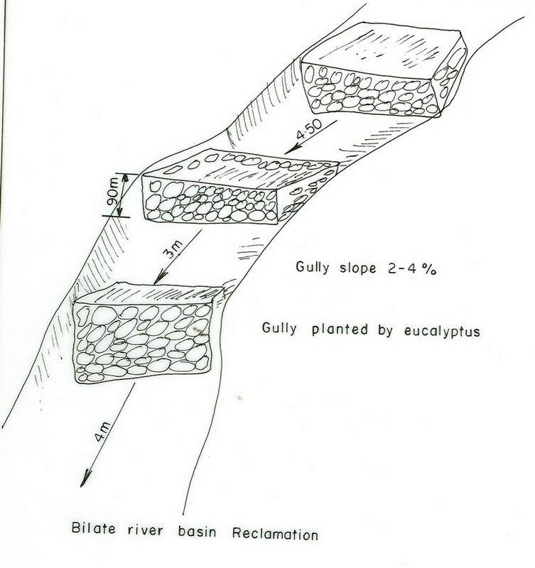
Retention/infiltration ditch/pit, sediment/sand trap
Vertical interval between structures (m): 0.5
Depth of ditches/pits/dams (m): 0.6
Width of ditches/pits/dams (m): 0.7
Length of ditches/pits/dams (m): 4
Height of bunds/banks/others (m): 0.75
Width of bunds/banks/others (m): 0.6
Terrace: backward sloping
Vertical interval between structures (m): 1.5
Spacing between structures (m): 12
Depth of ditches/pits/dams (m): 0.9
Width of ditches/pits/dams (m): 0.5
Length of ditches/pits/dams (m): 50-75
Bund/ bank: level
Vertical interval between structures (m): 1.2
Spacing between structures (m): 10
Depth of ditches/pits/dams (m): 0.6
Width of ditches/pits/dams (m): 0.7
Length of ditches/pits/dams (m): 50-80
Height of bunds/banks/others (m): 0.75
Construction material (earth): Most of the structural measures are made by earth involving excavation and embankment.
Construction material (stone): Stone is mainly used for demonstration.
Slope (which determines the spacing indicated above): 10%
If the original slope has changed as a result of the Technology, the slope today is: 8%
Lateral gradient along the structure: 0%
Vegetation is used for stabilisation of structures.
Change of land use type: The land after treatment is closed
Control / change of species composition: Grazing land changed to plantation and cropping
Other type of management: change of management / intensity level - Grazing land changed to plantation and cropping
4.2 ข้อมูลทั่วไปเกี่ยวกับการคำนวณปัจจัยนำเข้าและค่าใช้จ่าย
อื่นๆ หรือสกุลเงินประจำชาติ (ระบุ):
Birr
If relevant, indicate exchange rate from USD to local currency (e.g. 1 USD = 79.9 Brazilian Real): 1 USD =:
8.5
ระบุค่าเฉลี่ยของค่าจ้างในการจ้างแรงงานต่อวัน:
0.60
4.3 กิจกรรมเพื่อการจัดตั้ง
| กิจกรรม | Timing (season) | |
|---|---|---|
| 1. | Land preparation | September, october |
| 2. | Sugar cane planting | November |
| 3. | Sugar cane cultivation | January/August |
| 4. | Casava planting | April |
| 5. | Casava cultivation | June |
| 6. | Maize planting | January-1st plough, April 2nd plough |
| 7. | Maize cultivation | June |
| 8. | Sweet potato planting | September |
| 9. | Sweet potato cultivation | October |
| 10. | Fruite trees | June |
| 11. | Digging foundation | November-February |
| 12. | Forming embankment | November-February |
| 13. | Side wall shaping | November-February |
| 14. | Planting trees and shrubs | March-1st planting & June 2nd planting |
| 15. | Excluding animals by fencing and guarding | all year |
| 16. | Construct cutoff drain | dry season |
| 17. | Establish buffer zone between Area enclosure and crop land by strip of plantation | June/July |
| 18. | Construct earth checks and trenches in the gully | dry season |
4.4 ค่าใช้จ่ายของปัจจัยนำเข้าที่จำเป็นสำหรับการจัดตั้ง
| ปัจจัยนำเข้า | หน่วย | ปริมาณ | ค่าใช้จ่ายต่อหน่วย | ค่าใช้จ่ายทั้งหมดต่อปัจจัยนำเข้า | %ของค่าใช้จ่ายที่ก่อให้เกิดขึ้นโดยผู้ใช้ที่ดิน | |
|---|---|---|---|---|---|---|
| แรงงาน | Labour | ha | 1.0 | 282.3 | 282.3 | 100.0 |
| อุปกรณ์ | Tools | ha | 1.0 | 270.6 | 270.6 | 100.0 |
| วัสดุด้านพืช | Seedlings | ha | 1.0 | 117.6 | 117.6 | 100.0 |
| ค่าใช้จ่ายทั้งหมดของการจัดตั้งเทคโนโลยี | 670.5 | |||||
| Total costs for establishment of the Technology in USD | 78.88 | |||||
แสดงความคิดเห็น:
Duration of establishment phase: 24 month(s)
4.5 การบำรุงรักษาสภาพหรือกิจกรรมที่เกิดขึ้นเป็นประจำ
| กิจกรรม | ช่วงระยะเวลา/ความถี่ | |
|---|---|---|
| 1. | Land preparation | september, october / 2 times |
| 2. | Sweet potato planting | September / each cropping season |
| 3. | Sweet potato cultivation | October / each cropping season |
| 4. | Maize planting | January/April / each cropping season |
| 5. | Maize cultivation | June / each cropping season |
| 6. | Teff sawing | |
| 7. | Teff weeding | |
| 8. | Prunning | october /once |
| 9. | Mulching | october /once |
| 10. | Thining | october /once |
| 11. | Fencing | any time /once |
| 12. | Weeding | June/each cropping season |
| 13. | Cultivation | March/each cropping season |
| 14. | Replanting | June/each cropping season |
| 15. | Repair in breaks | November-February/each cropping season |
| 16. | Fence | each cropping season |
| 17. | Repair breaks on cutoff drain and earth checks | dry season / 2 years |
| 18. | Prunning, weeding and cultivation | end of rains / each cropping season |
4.6 ค่าใช้จ่ายของปัจจัยนำเข้าและกิจกรรมที่เกิดขึ้นเป็นประจำที่ต้องการการบำรุงรักษา (ต่อปี)
แสดงความคิดเห็น:
Machinery/ tools: spade, hoe
Length and width of structure
4.7 ปัจจัยสำคัญที่สุดที่มีผลกระทบต่อค่าใช้จ่าย
ปัจจัยสำคัญที่สุดที่มีผลกระทบต่อค่าใช้จ่ายต่างๆ:
Factors affecting costs in this technology are the depth and width of gully, steepness of slope, planting and replanting of vegetative materials.
5. สิ่งแวดล้อมทางธรรมชาติและของมนุษย์
5.1 ภูมิอากาศ
ฝนประจำปี
- < 250 ม.ม.
- 251-500 ม.ม.
- 501-750 ม.ม.
- 751-1,000 ม.ม.
- 1,001-1,500 ม.ม.
- 1,501-2,000 ม.ม.
- 2,001-3,000 ม.ม.
- 3,001-4,000 ม.ม.
- > 4,000 ม.ม.
เขตภูมิอากาศเกษตร
- กึ่งชุ่มชื้น
5.2 สภาพภูมิประเทศ
ค่าเฉลี่ยความลาดชัน:
- ราบเรียบ (0-2%)
- ลาดที่ไม่ชัน (3-5%)
- ปานกลาง (6-10%)
- เป็นลูกคลื่น (11-15%)
- เป็นเนิน (16-30%)
- ชัน (31-60%)
- ชันมาก (>60%)
ธรณีสัณฐาน:
- ที่ราบสูง/ที่ราบ
- สันเขา
- ไหล่เขา
- ไหล่เนินเขา
- ตีนเนิน
- หุบเขา
ระดับความสูง:
- 0-100 เมตร
- 101-500 เมตร
- 501-1,000 เมตร
- 1,001-1,500 เมตร
- 1,501-2,000 เมตร
- 2,001-2,500 เมตร
- 2,501-3,000 เมตร
- 3,001-4,000 เมตร
- > 4,000 เมตร
ความคิดเห็นและข้อมูลจำเพาะเพิ่มเติมเรื่องสภาพภูมิประเทศ:
Slopes on average: Moderate (ranked 1, about 70%), gentle and rolling (both ranked 2) and flat (ranked 3)
5.3 ดิน
ค่าเฉลี่ยความลึกของดิน:
- ตื้นมาก (0-20 ซ.ม.)
- ตื้น (21-50 ซ.ม.)
- ลึกปานกลาง (51-80 ซ.ม.)
- ลึก (81-120 ซ.ม.)
- ลึกมาก (>120 ซ.ม.)
เนื้อดิน (ดินชั้นบน):
- ปานกลาง (ดินร่วน ทรายแป้ง)
อินทรียวัตถุในดิน:
- ปานกลาง (1-3%)
(ถ้ามี) ให้แนบคำอธิบายเรื่องดินแบบเต็มหรือระบุข้อมูลที่มีอยู่ เช่น ชนิดของดิน ค่า pH ของดินหรือความเป็นกรดของดิน ความสามารถในการแลกเปลี่ยนประจุบวก ไนโตรเจน ความเค็ม เป็นต้น:
Soil depth on average: Deep (Soils are very deep (75%))
Soil texture: Medium (fertile loam soils)
Soil fertility is medium (ranked 1) and high (ranked 2)
Topsoil organic matter: Medium (ranked 1, in the crop lands), low (ranked 2, degraded areas) and high (ranked 3, around the homestead)
Soil water storage capacity: Medium (ranked 1, on crop land) and high (ranked 2, on flat plateau land)
5.6 ลักษณะของผู้ใช้ที่ดินที่นำเทคโนโลยีไปปฏิบัติใช้
แนวทางการตลาดของระบบการผลิต:
- เพื่อการยังชีพ (หาเลี้ยงตนเอง)
- mixed (subsistence/ commercial)
รายได้ที่มาจากนอกฟาร์ม:
- 10-50% ของรายได้ทั้งหมด
ระดับของความมั่งคั่งโดยเปรียบเทียบ:
- พอมีพอกิน
ระดับของการใช้เครื่องจักรกล:
- งานที่ใช้แรงกาย
- การใช้กำลังจากสัตว์
ระบุลักษณะอื่นๆที่เกี่ยวข้องของผู้ใช้ที่ดิน:
Population density: > 500 persons/km2
Annual population growth: 2% - 3%
5% of the land users are rich.
10% of the land users are average wealthy.
45% of the land users are poor.
40% of the land users are poor.
Off-farm income specification: Farmers who have SWC measures on their land produce more and hence have better financial income, which could allow them get involved in petty trade and other activities.
Level of mechanization: Animal traction (ranked 1, crop lands) and manual work ( ranked 2, homstead and gully lands)
Market orientation of cropland production system: subsistence (self-supply, maize) and mixed (subsistence/ commercial, sweet potato, teff, coffee)
5.7 Average area of land used by land users applying the Technology
- < 0.5 เฮกตาร์
- 0.5-1 เฮกตาร์
- 1-2 เฮกตาร์
- 2-5 เฮกตาร์
- 5-15 เฮกตาร์
- 15-50 เฮกตาร์
- 50-100 เฮกตาร์
- 100-500 เฮกตาร์
- 500-1,000 เฮกตาร์
- 1,000-10,000 เฮกตาร์
- >10,000 เฮกตาร์
แสดงความคิดเห็น:
Cropland: 0.5-1 ha (more than 80% of farmers) and 1-2 ha
grazing land: 0.5-1 ha (communal grazing lands are severly degraded)
6. ผลกระทบและสรุปคำบอกกล่าว
6.1 ผลกระทบในพื้นที่ดำเนินการ (On-site) จากการใช้เทคโนโลยี
ผลกระทบทางด้านเศรษฐกิจและสังคม
การผลิต
การผลิตพืชผล
การผลิตพืชที่ใช้เลี้ยงปศุสัตว์
คุณภาพพืชที่ใช้เลี้ยงปศุสัตว์
พื้นที่สำหรับการผลิต
แสดงความคิดเห็น/ระบุ:
Shortage of grazing land: Animals are thethered in a small plots
รายได้และค่าใช้จ่าย
รายได้จากฟาร์ม
ผลกระทบด้านสังคมวัฒนธรรมอื่น ๆ
สถาบันของชุมชน
แสดงความคิดเห็น/ระบุ:
teams are formed
สถาบันแห่งชาติ
SLM หรือความรู้เรื่องความเสื่อมโทรมของที่ดิน
การบรรเทาความขัดแย้ง
แสดงความคิดเห็น/ระบุ:
many wants to be beneficiaries but only the poor given the opportunities
ผลกระทบด้านนิเวศวิทยา
ดิน
ความชื้นในดิน
สิ่งปกคลุมดิน
การสูญเสียดิน
ผลกระทบด้านนิเวศวิทยาอื่น ๆ
Biodiversity enhancement
6.2 ผลกระทบนอกพื้นที่ดำเนินการ (Off-site) จากการใช้เทคโนโลยี
น้ำท่วมพื้นที่ท้ายน้ำ
แสดงความคิดเห็น/ระบุ:
all runoff retained
การทับถมของดินตะกอนพื้นที่ท้ายน้ำ
แสดงความคิดเห็น/ระบุ:
all soil trapped
6.4 การวิเคราะห์ค่าใช้จ่ายและผลประโยชน์ที่ได้รับ
ผลประโยชน์ที่ได้รับเปรียบเทียบกับค่าใช้จ่ายในการจัดตั้งเป็นอย่างไร (จากมุมมองของผู้ใช้ที่ดิน)
ผลตอบแทนระยะสั้น:
ด้านบวกเล็กน้อย
ผลตอบแทนระยะยาว:
ด้านบวก
ผลประโยชน์ที่ได้รับเปรียบเทียบกับค่าใช้จ่ายในการบำรุงรักษาหรือต้นทุนที่เกิดขึ้นซ้ำอีก เป็นอย่างไร (จากมุมมองของผู้ใช้ที่ดิน)
ผลตอบแทนระยะสั้น:
ด้านบวก
ผลตอบแทนระยะยาว:
ด้านบวก
6.5 การปรับตัวของเทคโนโลยี
แสดงความคิดเห็น:
50 land user families have adopted the Technology with external material support
7. การอ้างอิงและการเชื่อมต่อ
7.1 วิธีการและแหล่งข้อมูล
ลิงก์และโมดูล
ขยายทั้งหมด ย่อทั้งหมดลิงก์
ไม่มีลิงก์
โมดูล
ไม่มีโมดูล