Planting pits and stone lines [ไนเจอร์]
- ผู้สร้างสรรค์:
- การอัพเดท:
- ผู้รวบรวม: Charles Bielders
- ผู้เรียบเรียง: –
- ผู้ตรวจสอบ: Deborah Niggli, David Streiff, Alexandra Gavilano
Tassa avec cordon pierreux (french)
technologies_1100 - ไนเจอร์
- บทสรุปทั้งหมดในรูปแบบของ PDF
- บทสรุปทั้งหมดในรูปแบบของ PDF เพื่อพิมพ์
- บทสรุปทั้งหมดในรูปหน้าเว็บ
- บทสรุปทั้งหมด (ไม่มีการจัดเรียง)
- Planting pits and stone lines: 6 มิถุนายน 2019 (public)
- Planting pits and stone lines: 4 เมษายน 2018 (inactive)
- Planting pits and stone lines: 4 เมษายน 2018 (inactive)
- Planting pits and stone lines: 4 พฤษภาคม 2017 (inactive)
- Planting pits and stone lines: 28 เมษายน 2017 (inactive)
- Planting pits and stone lines: 28 เมษายน 2017 (inactive)
ดูส่วนย่อย
ขยายทั้งหมด ย่อทั้งหมด1. ข้อมูลทั่วไป
1.2 รายละเอียดที่ติดต่อได้ของผู้รวบรวมและองค์กรที่เกี่ยวข้องในการประเมินและการจัดเตรียมทำเอกสารของเทคโนโลยี
ผู้เชี่ยวชาญ SLM:
ผู้เชี่ยวชาญ SLM:
Oudou Noufou Amadou
PDRT
ชื่อของโครงการซึ่งอำนวยความสะดวกในการทำเอกสารหรือการประเมินเทคโนโลยี (ถ้าเกี่ยวข้อง)
Projet de développement rural de Tahoua, Niger (PDRT)ชื่อของโครงการซึ่งอำนวยความสะดวกในการทำเอกสารหรือการประเมินเทคโนโลยี (ถ้าเกี่ยวข้อง)
Book project: where the land is greener - Case Studies and Analysis of Soil and Water Conservation Initiatives Worldwide (where the land is greener)ชื่อของโครงการซึ่งอำนวยความสะดวกในการทำเอกสารหรือการประเมินเทคโนโลยี (ถ้าเกี่ยวข้อง)
Book project: Water Harvesting – Guidelines to Good Practice (Water Harvesting)ชื่อขององค์กรซึ่งอำนวยความสะดวกในการทำเอกสารหรือการประเมินเทคโนโลยี (ถ้าเกี่ยวข้อง)
Université catholique de Louvain (Université catholique de Louvain) - เบลเยียมชื่อขององค์กรซึ่งอำนวยความสะดวกในการทำเอกสารหรือการประเมินเทคโนโลยี (ถ้าเกี่ยวข้อง)
Centre for Agriculture in the Tropics and Subtropics (Centre for Agriculture in the Tropics and Subtropics) - เยอรมนีชื่อขององค์กรซึ่งอำนวยความสะดวกในการทำเอกสารหรือการประเมินเทคโนโลยี (ถ้าเกี่ยวข้อง)
ICRISAT (ICRISAT) - ไนเจอร์1.3 เงื่อนไขการใช้ข้อมูลที่ได้บันทึกผ่านทาง WOCAT
ผู้รวบรวมและวิทยากรหลักยอมรับเงื่อนไขเกี่ยวกับการใช้ข้อมูลที่ถูกบันทึกผ่านทาง WOCAT:
ใช่
1.5 Reference to Questionnaire(s) on SLM Approaches (documented using WOCAT)
Approche participative de réhabilitation des terres individuelles et … [ไนเจอร์]
Planification et gestion des terres individuelles et villageoises sur la base d’une participation des usagers ; promotion simultanée des activités des femmes.
- ผู้รวบรวม: Eric Tielkes
2. การอธิบายลักษณะของเทคโนโลยี SLM
2.1 การอธิบายแบบสั้น ๆ ของเทคโนโลยี
คำจำกัดความของเทคโนโลยี:
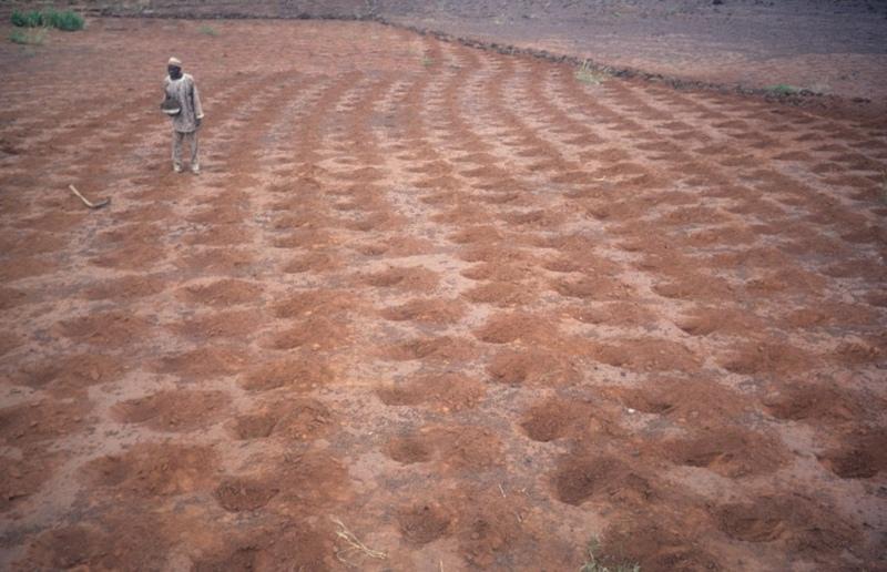
Rehabilitation of degraded land through manured planting pits, in combination with contour stone lines. The planting pits are used for millet and sorghum production on gentle slopes.
2.2 การอธิบายแบบละเอียดของเทคโนโลยี
คำอธิบาย:
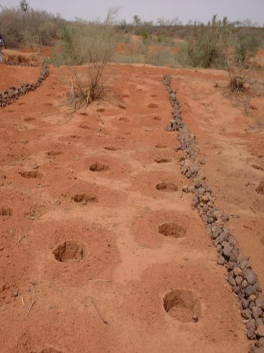
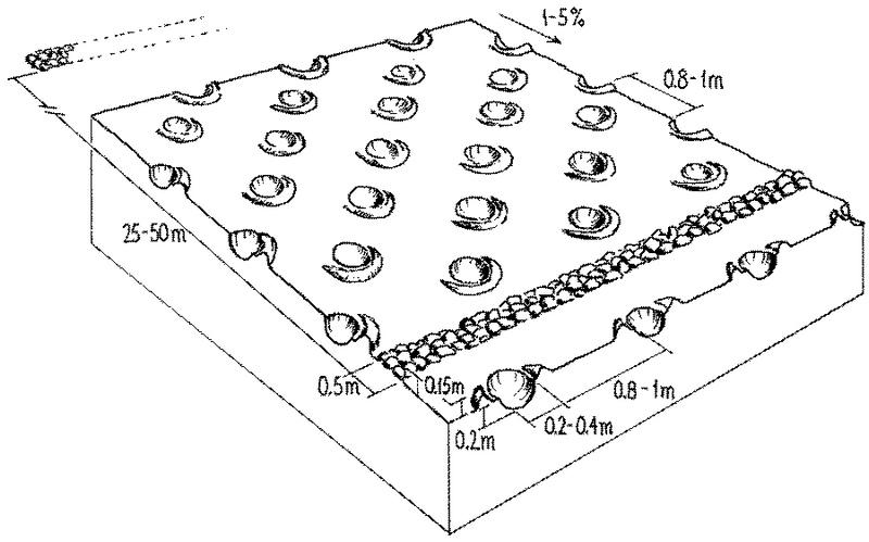
The combination of planting pits (tassa) with stone lines is used for the rehabilitation of degraded, crusted land. This technology is mainly applied in semi-arid areas on sandy/loamy plains, often covered with a hard pan, and with slopes below 5%. These denuded plains are brought into crop cultivation by the combination of tassa and stone lines. Planting pits are holes of 20-30 cm diameter and 20-25 cm depth, spaced about 1 m apart in each direction. The excavated earth is formed into a small ridge downslope of the pit. Manure is added to each pit, but its availability is sometimes a problem. At the start of the rainy season, millet or sorghum is sown in these pits. The overall aim of the system is to capture and hold
rainfall and runoff, and thereby improve water infiltration, while increasing nutrient availability.
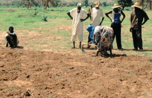
Stone lines are small structures, at most three stones wide and sometimes only one stone high. The distance between the lines is a function of the slope and availability of stone. Typically they are sited 25-50 m apart on 2-5% slopes. Stones are usually collected from nearby sites - though sometimes up to 5-10 km away and brought to the fields by donkey carts or lorries (when a project is involved). They are positioned manually, along the contour. Stone lines are intended to slow down runoff. They thereby increase the rate of infiltration, while simultaneously protecting the planting pits from sedimentation.
Often grass establishes between the stones, which helps increase infiltration further and accelerates the accumulation of fertile sediment. Wind-blown particles may also build up along the stone lines due to a local reduction in wind velocity. The accumulation of sediment along the stone lines in turn favours water infiltration on the upslope side. This then improves plant growth, which further enhances the effect of the system. Construction does not require heavy machinery (unless the stones need to be brought from afar by lorry).
The technique is therefore favourable to spontaneous adoption. Stone lines may need to be repaired annually, especially if heavy rains have occurred. Manure is placed every second (or third) year into the previously dug pits and sand is removed annually: normally the highest plant production is during the second year after manure application.
2.3 รูปภาพของเทคโนโลยี
อัลบั้มสื่อบันทึก
2.5 ประเทศภูมิภาค หรือสถานที่ตั้งที่เทคโนโลยีได้นำไปใช้และได้รับการครอบคลุมโดยการประเมินนี้
ประเทศ:
ไนเจอร์
ภูมิภาค/รัฐ/จังหวัด:
Niger, Tahoua
ระบุการกระจายตัวของเทคโนโลยี:
- กระจายไปอย่างสม่ำเสมอในพื้นที่
If the Technology is evenly spread over an area, specify area covered (in km2):
40.0
แสดงความคิดเห็น:
Total area covered by the SLM Technology is 40 km2.
2.7 คำแนะนำของเทคโนโลยี
ให้ระบุว่าเทคโนโลยีถูกแนะนำเข้ามาอย่างไร:
- ทางโครงการหรือจากภายนอก
3. การจัดประเภทของเทคโนโลยี SLM
3.1 วัตถุประสงค์หลักของเทคโนโลยี
- ลด ป้องกัน ฟื้นฟู การเสื่อมโทรมของที่ดิน
3.2 ประเภทของการใช้ที่ดินในปัจจุบันที่ได้นำเทคโนโลยีไปใช้

พื้นที่ปลูกพืช
- การปลูกพืชล้มลุกอายุปีเดียว
Annual cropping - Specify crops:
- cereals - millet
- cereals - sorghum
- legumes and pulses - peas
แสดงความคิดเห็น:
major food crop: Millet and sorghum
Major land use problems (compiler’s opinion): Soil fertility decline is the basic problem: this is due to degradation and nutrient mining. Loss of limited rainwater by runoff and loss of soil cover result in low crop production and food insufficiency. This occurs in combination with lack of pasture, resulting in shortage of manure.
3.4 การใช้น้ำ
การใช้น้ำของที่ดินที่มีการใช้เทคโนโลยีอยู่:
- จากน้ำฝน
3.5 กลุ่ม SLM ที่ตรงกับเทคโนโลยีนี้
- การเก็บเกี่ยวน้ำ
- การจัดการด้านชลประทาน (รวมถึงการลำเลียงส่งน้ำ การระบายน้ำ)
3.6 มาตรการ SLM ที่ประกอบกันเป็นเทคโนโลยี

มาตรการจัดการพืช
- A7: Others

มาตรการอนุรักษ์ด้วยโครงสร้าง
- S11: อื่น ๆ
แสดงความคิดเห็น:
Specification of other agronomic measures: Manure application (supplementary)
Specification of other structural measures: stone lines, planting pits
Type of agronomic measures: manure / compost / residues
3.7 รูปแบบหลักของการเสื่อมโทรมของที่ดินที่ได้รับการแก้ไขโดยเทคโนโลยี

การกัดกร่อนของดินโดยน้ำ
- Wt (Loss of topsoil): การสูญเสียดินชั้นบนหรือการกัดกร่อนที่ผิวดิน

การกัดกร่อนของดินโดยลม
- Et (Loss of topsoil): การสูญเสียดินชั้นบน

การเสื่อมโทรมของดินทางด้านเคมี
- Cn (Fertility decline): ความอุดมสมบูรณ์และปริมาณอินทรียวัตถุในดินถูกทำให้ลดลงไป (ไม่ได้เกิดจากสาเหตุการกัดกร่อน)

การเสื่อมโทรมของดินทางด้านกายภาพ
- Pc (Compaction): การอัดแน่น
- Pk (Slaking and crusting): การอุดตันของช่องว่างในดินหรือรูพรุน
แสดงความคิดเห็น:
Main type of degradation addressed: Wt: loss of topsoil / surface erosion, Et: loss of topsoil, Cn: fertility decline and reduced organic matter content, Pc: compaction, Pk: sealing and crusting
3.8 การป้องกัน การลดลง หรือการฟื้นฟูความเสื่อมโทรมของที่ดิน
ระบุเป้าหมายของเทคโนโลยีกับความเสื่อมโทรมของที่ดิน:
- ฟื้นฟูบำบัดที่ดินที่เสื่อมโทรมลงอย่างมาก
4. ข้อมูลจำเพาะด้านเทคนิค กิจกรรมการนำไปปฏิบัติใช้ ปัจจัยนำเข้า และค่าใช้จ่าย
4.1 แบบแปลนทางเทคนิคของเทคโนโลยี
ข้อมูลจำเพาะด้านเทคนิค (แบบแปลนทางเทคนิคของเทคโนโลยี):
Planting pits (tassa) capture rainfall runoff for cultivation of annual crops, and the stone lines - spaced at 25-50 metres apart - help hold back moisture and eroded soil.
Technical knowledge required for field staff / advisors: moderate
Technical knowledge required for land users: low
Main technical functions: increase in organic matter, increase of infiltration, increase / maintain water stored in soil, water harvesting / increase water supply, increase in soil fertility, increases natural regeneration of trees
Secondary technical functions: reduction of slope length, improvement of ground cover, improvement of soil structure
Manure / compost / residues
Quantity/ density: 2.5 t/ha
Structural measure: stone lines
Spacing between structures (m): 25-50planting pits
Structural measure: planting pits
Vertical interval between structures (m): 1
Spacing between structures (m): 1
Depth of ditches/pits/dams (m): 0.2-0.25
Width of ditches/pits/dams (m): 0.2-0.3
Slope (which determines the spacing indicated above): <5%
ผู้เขียน:
Mats Gurtner
4.2 ข้อมูลทั่วไปเกี่ยวกับการคำนวณปัจจัยนำเข้าและค่าใช้จ่าย
ระบุสกุลเงินที่ใช้คำนวณค่าใช้จ่าย:
- USD
4.3 กิจกรรมเพื่อการจัดตั้ง
| กิจกรรม | Timing (season) | |
|---|---|---|
| 1. | Digging pits (tassa): the excavated earth | dry season (November to May) |
| 2. | Digging out stones from nearby sites | dry season (November to May) |
| 3. | Transporting stones | dry season (November to May) |
| 4. | Aligning the stones along the contour with the help of a ‘water tube | dry season (November to May) |
4.4 ค่าใช้จ่ายของปัจจัยนำเข้าที่จำเป็นสำหรับการจัดตั้ง
| ปัจจัยนำเข้า | หน่วย | ปริมาณ | ค่าใช้จ่ายต่อหน่วย | ค่าใช้จ่ายทั้งหมดต่อปัจจัยนำเข้า | %ของค่าใช้จ่ายที่ก่อให้เกิดขึ้นโดยผู้ใช้ที่ดิน | |
|---|---|---|---|---|---|---|
| แรงงาน | Digging tassa | persons/day/ha | 100.0 | 1.5 | 150.0 | 100.0 |
| แรงงาน | Building stone lines | persons/day/ha | 26.666 | 1.5 | 40.0 | 100.0 |
| อุปกรณ์ | Tools for tassa | ha | 1.0 | 5.0 | 5.0 | 100.0 |
| อุปกรณ์ | Tools for stone lines | ha | 1.0 | 5.0 | 5.0 | 75.0 |
| ปุ๋ยและสารฆ่า/ยับยั้งการเจริญเติบโตของสิ่งมีชีวิต (ไบโอไซด์) | Compost/manure | ha | 1.0 | 5.0 | 5.0 | 100.0 |
| อื่น ๆ | Transporting stones with lorri | ha | 1.0 | 40.0 | 40.0 | |
| ค่าใช้จ่ายทั้งหมดของการจัดตั้งเทคโนโลยี | 245.0 | |||||
| Total costs for establishment of the Technology in USD | 245.0 | |||||
แสดงความคิดเห็น:
Duration of establishment phase: 12 month(s)
4.5 การบำรุงรักษาสภาพหรือกิจกรรมที่เกิดขึ้นเป็นประจำ
| กิจกรรม | ช่วงระยะเวลา/ความถี่ | |
|---|---|---|
| 1. | Manuring the pits with approx 250 g per pit | dry season (November to May) / initial establishment |
| 2. | Manuring the pits with about 250 g per pit (2.5 t/ha) | October/November or March-May / every second year |
| 3. | Removing sand from the tassa | March-May/annual |
| 4. | Check and repair stone lines | annually and after heavy rains. |
4.6 ค่าใช้จ่ายของปัจจัยนำเข้าและกิจกรรมที่เกิดขึ้นเป็นประจำที่ต้องการการบำรุงรักษา (ต่อปี)
| ปัจจัยนำเข้า | หน่วย | ปริมาณ | ค่าใช้จ่ายต่อหน่วย | ค่าใช้จ่ายทั้งหมดต่อปัจจัยนำเข้า | %ของค่าใช้จ่ายที่ก่อให้เกิดขึ้นโดยผู้ใช้ที่ดิน | |
|---|---|---|---|---|---|---|
| แรงงาน | Labour | persons/day/ha | 21.0 | 1.5 | 31.5 | 100.0 |
| อุปกรณ์ | Tools for tassa | ha | 1.0 | 1.0 | 1.0 | 100.0 |
| ปุ๋ยและสารฆ่า/ยับยั้งการเจริญเติบโตของสิ่งมีชีวิต (ไบโอไซด์) | Compost/manure | ha | 1.0 | 2.5 | 2.5 | 100.0 |
| ค่าใช้จ่ายทั้งหมดของการบำรุงรักษาสภาพเทคโนโลยี | 35.0 | |||||
| Total costs for maintenance of the Technology in USD | 35.0 | |||||
แสดงความคิดเห็น:
Machinery/ tools: hoe, pick-axe, shovel, donkey cart, (lorries)
The costs are based on 300 m of stone lines per hectare (on a 3-4% slope). Maintenance costs refer to removing sand from the pits from the second year onwards, and to the application of manure every second year (costs are spread on an annual basis). If applicable, costs for transporting the manure need to be added. The general assumption in these calculations is that adequate manure is readily available close by. The availability of stones is the main factor in determining costs - though labour availability can affect prices also. If stones are not available in the field or nearby (from where they can be transported by donkey cart), they have to be carried by lorries, which is much more expensive. The costs here refer to fuel costs only, paid by a project: they do not include depreciation of lorries.
5. สิ่งแวดล้อมทางธรรมชาติและของมนุษย์
5.1 ภูมิอากาศ
ฝนประจำปี
- < 250 ม.ม.
- 251-500 ม.ม.
- 501-750 ม.ม.
- 751-1,000 ม.ม.
- 1,001-1,500 ม.ม.
- 1,501-2,000 ม.ม.
- 2,001-3,000 ม.ม.
- 3,001-4,000 ม.ม.
- > 4,000 ม.ม.
ระบุปริมาณน้ำฝนเฉลี่ยรายปี (ถ้ารู้) :หน่วย ม.ม.
390.00
เขตภูมิอากาศเกษตร
- กึ่งแห้งแล้ง
5.2 สภาพภูมิประเทศ
ค่าเฉลี่ยความลาดชัน:
- ราบเรียบ (0-2%)
- ลาดที่ไม่ชัน (3-5%)
- ปานกลาง (6-10%)
- เป็นลูกคลื่น (11-15%)
- เป็นเนิน (16-30%)
- ชัน (31-60%)
- ชันมาก (>60%)
ธรณีสัณฐาน:
- ที่ราบสูง/ที่ราบ
- สันเขา
- ไหล่เขา
- ไหล่เนินเขา
- ตีนเนิน
- หุบเขา
ระดับความสูง:
- 0-100 เมตร
- 101-500 เมตร
- 501-1,000 เมตร
- 1,001-1,500 เมตร
- 1,501-2,000 เมตร
- 2,001-2,500 เมตร
- 2,501-3,000 เมตร
- 3,001-4,000 เมตร
- > 4,000 เมตร
5.3 ดิน
ค่าเฉลี่ยความลึกของดิน:
- ตื้นมาก (0-20 ซ.ม.)
- ตื้น (21-50 ซ.ม.)
- ลึกปานกลาง (51-80 ซ.ม.)
- ลึก (81-120 ซ.ม.)
- ลึกมาก (>120 ซ.ม.)
เนื้อดิน (ดินชั้นบน):
- หยาบ/เบา (ดินทราย)
- ปานกลาง (ดินร่วน ทรายแป้ง)
อินทรียวัตถุในดิน:
- ต่ำ (<1%)
(ถ้ามี) ให้แนบคำอธิบายเรื่องดินแบบเต็มหรือระบุข้อมูลที่มีอยู่ เช่น ชนิดของดิน ค่า pH ของดินหรือความเป็นกรดของดิน ความสามารถในการแลกเปลี่ยนประจุบวก ไนโตรเจน ความเค็ม เป็นต้น:
Soil depth on average: Also deep
Soil fertility is low - very low
Soil drainage / infiltration is good, though infiltration is low where there is a crust
5.6 ลักษณะของผู้ใช้ที่ดินที่นำเทคโนโลยีไปปฏิบัติใช้
แนวทางการตลาดของระบบการผลิต:
- เพื่อการยังชีพ (หาเลี้ยงตนเอง)
- mixed (subsistence/ commercial)
รายได้ที่มาจากนอกฟาร์ม:
- > 50% ของรายได้ทั้งหมด
ระดับของการใช้เครื่องจักรกล:
- งานที่ใช้แรงกาย
- การใช้กำลังจากสัตว์
ระบุลักษณะอื่นๆที่เกี่ยวข้องของผู้ใช้ที่ดิน:
Off-farm income specification: remittances from out-migration of labour, commerce and crafts
5.7 Average area of land used by land users applying the Technology
- < 0.5 เฮกตาร์
- 0.5-1 เฮกตาร์
- 1-2 เฮกตาร์
- 2-5 เฮกตาร์
- 5-15 เฮกตาร์
- 15-50 เฮกตาร์
- 50-100 เฮกตาร์
- 100-500 เฮกตาร์
- 500-1,000 เฮกตาร์
- 1,000-10,000 เฮกตาร์
- >10,000 เฮกตาร์
5.8 กรรมสิทธิ์ในที่ดิน สิทธิในการใช้ที่ดินและสิทธิในการใช้น้ำ
กรรมสิทธิ์ในที่ดิน:
- รายบุคคล ได้รับสิทธิครอบครอง
สิทธิในการใช้ที่ดิน:
- รายบุคคล
6. ผลกระทบและสรุปคำบอกกล่าว
6.1 ผลกระทบในพื้นที่ดำเนินการ (On-site) จากการใช้เทคโนโลยี
ผลกระทบทางด้านเศรษฐกิจและสังคม
การผลิต
การผลิตพืชผล
รายได้และค่าใช้จ่าย
รายได้จากฟาร์ม
ภาระงาน
ผลกระทบทางด้านเศรษฐกิจและสังคมอื่น ๆ
input contstraints
ผลกระทบด้านสังคมวัฒนธรรมอื่น ๆ
สถาบันของชุมชน
แสดงความคิดเห็น/ระบุ:
Through mutual aid in technology implementation
SLM หรือความรู้เรื่องความเสื่อมโทรมของที่ดิน
การบรรเทาความขัดแย้ง
แสดงความคิดเห็น/ระบุ:
Land use rights conflicts of rehabilitated land and conflicts between farmers and pastoralists, because pasture land is being turned into cultivated fields
ผลกระทบด้านนิเวศวิทยา
วัฐจักรน้ำหรือน้ำบ่า
การระบายน้ำส่วนเกิน
ดิน
ความชื้นในดิน
การสูญเสียดิน
อินทรียวัตถุในดิน/ต่ำกว่าดินชั้น C
ผลกระทบด้านนิเวศวิทยาอื่น ๆ
soil fertility
long-term soil cover
6.2 ผลกระทบนอกพื้นที่ดำเนินการ (Off-site) จากการใช้เทคโนโลยี
น้ำท่วมพื้นที่ท้ายน้ำ
การทับถมของดินตะกอนพื้นที่ท้ายน้ำ
6.4 การวิเคราะห์ค่าใช้จ่ายและผลประโยชน์ที่ได้รับ
ผลประโยชน์ที่ได้รับเปรียบเทียบกับค่าใช้จ่ายในการจัดตั้งเป็นอย่างไร (จากมุมมองของผู้ใช้ที่ดิน)
ผลตอบแทนระยะสั้น:
ด้านบวก
ผลตอบแทนระยะยาว:
ด้านบวกอย่างมาก
ผลประโยชน์ที่ได้รับเปรียบเทียบกับค่าใช้จ่ายในการบำรุงรักษาหรือต้นทุนที่เกิดขึ้นซ้ำอีก เป็นอย่างไร (จากมุมมองของผู้ใช้ที่ดิน)
ผลตอบแทนระยะสั้น:
ด้านบวก
ผลตอบแทนระยะยาว:
ด้านบวกอย่างมาก
6.5 การปรับตัวของเทคโนโลยี
แสดงความคิดเห็น:
There is a moderate trend towards spontaneous adoption of the Technology
Comments on adoption trend: There is moderate growing spontaneous adoption (for rehabilitation of the plains), but there are no estimates available regarding the extent.
6.7 จุดแข็ง / ข้อได้เปรียบ / โอกาสของเทคโนโลยี
| จุดแข็ง / ข้อได้เปรียบ / โอกาสในทัศนคติของผู้รวบรวมหรือวิทยากรหลัก |
|---|
|
Simple technology, individually applicable in the dry season, requiring only very little training/knowledge and no special equipment. |
| Making best use of manure, which is a limiting resource. |
| Increase in agricultural production. |
| Rehabilitation of degraded and denuded land: bringing back into production formerly uncultivated land; extension of farm land to the plateaus. |
6.8 จุดอ่อน / ข้อเสียเปรียบ / ความเสี่ยงของเทคโนโลยีและวิธีการแก้ไข
| จุดอ่อน / ข้อเสียเปรียบ / ความเสี่ยงในทัศนคติของผู้รวบรวมหรือวิทยากรหลัก | มีวิธีการแก้ไขได้อย่างไร |
|---|---|
| Labour demanding technology for implementation and maintenance | Mechanisation of tasks: transportation of stones and manure. However, this would raise the cost. |
| Instability of planting pits in loose soil, increased erosion on steeper slopes and with heavier rains |
Avoid loose sandy soils and steep slopes. |
|
The effectiveness can be compromised if the various geo-morphological units (plateaus, slopes) are not treated simultaneously |
Catchment area approach if downstream flooding is an issue. |
|
Possibility of land use conflicts concerning rehabilitated land, in particular with pastoralists |
Better coordination/consultation before implementing the technology in an area. |
| Implementation constraint: availability of manure and/or stones and transporting manure/stones to the plateaus and slopes | Subsidise transport means (or supply donkey carts) or/and apply stone lines only in areas where there are stones available close to the fields. |
7. การอ้างอิงและการเชื่อมต่อ
7.1 วิธีการและแหล่งข้อมูล
7.2 การอ้างอิงถึงสิ่งตีพิมพ์
หัวข้อ, ผู้เขียน, ปี, หมายเลข ISBN:
Bety A, Boubacar A, Frölich W, Garba A, Kriegl M, Mabrouk A, Noufou O, Thienel M and Wincker H: Gestion durable desressources naturelles. Leçons tirées du savoir des paysans de l’Adar. Ministère de l’agriculture et de l’élevage, Niamey, 142 pp.. 19
หัวข้อ, ผู้เขียน, ปี, หมายเลข ISBN:
Hassane A, Martin Pand Reij C:Water harvesting, land rehabilitation and household food security in Niger: IFAD’s Soil and Water Conservation Project in IllelaDistrict. IFAD, Rome, 51 pp.. 2000.
หัวข้อ, ผู้เขียน, ปี, หมายเลข ISBN:
Mabrouk A, Tielkes E and Kriegl M: Conservation des eaux et des sols: Leçons des connaissances traditionnelles de la région de Tahoua, Niger. In: Renard, G., Neef, A,. Becker, K. and Von Oppen, M. (eds). de la région de Tahoua, Niger. 1998.
หัวข้อ, ผู้เขียน, ปี, หมายเลข ISBN:
Mabrouk A, Tielkes E and Kriegl M: Conservation des eaux et des sols: Leçons des connaissances traditionnelles de la région de Tahoua, Niger. In: Renard, G., Neef, A,. Becker, K. and Von Oppen, M. (eds). de la région de Tahoua, Niger. 1998.
หัวข้อ, ผู้เขียน, ปี, หมายเลข ISBN:
Mabrouk A, Tielkes E and Kriegl M: Conservation des eaux et des sols: Leçons des connaissances traditionnelles de la région de Tahoua, Niger. In: Renard, G., Neef, A,. Becker, K. and Von Oppen, M. (eds). de la région de Tahoua, Niger. 1998.
หัวข้อ, ผู้เขียน, ปี, หมายเลข ISBN:
Mabrouk A, Tielkes E and Kriegl M: Conservation des eaux et des sols: Leçons des connaissances traditionnelles de la région de Tahoua, Niger. In: Renard, G., Neef, A,. Becker, K. and Von Oppen, M. (eds). de la région de Tahoua, Niger. 1998.
หัวข้อ, ผู้เขียน, ปี, หมายเลข ISBN:
Mabrouk A, Tielkes E and Kriegl M: Conservation des eaux et des sols: Leçons des connaissances traditionnelles de la région de Tahoua, Niger. In: Renard, G., Neef, A,. Becker, K. and Von Oppen, M. (eds). de la région de Tahoua, Niger. 1998.
หัวข้อ, ผู้เขียน, ปี, หมายเลข ISBN:
Mabrouk A, Tielkes E and Kriegl M: Conservation des eaux et des sols: Leçons des connaissances traditionnelles de la région de Tahoua, Niger. In: Renard, G., Neef, A,. Becker, K. and Von Oppen, M. (eds). de la région de Tahoua, Niger. 1998.
หัวข้อ, ผู้เขียน, ปี, หมายเลข ISBN:
Mabrouk A, Tielkes E and Kriegl M: Conservation des eaux et des sols: Leçons des connaissances traditionnelles de la région de Tahoua, Niger. In: Renard, G., Neef, A,. Becker, K. and Von Oppen, M. (eds). de la région de Tahoua, Niger. 1998.
หัวข้อ, ผู้เขียน, ปี, หมายเลข ISBN:
Mabrouk A, Tielkes E and Kriegl M: Conservation des eaux et des sols: Leçons des connaissances traditionnelles de la région de Tahoua, Niger. In: Renard, G., Neef, A,. Becker, K. and Von Oppen, M. (eds). de la région de Tahoua, Niger. 1998.
ลิงก์และโมดูล
ขยายทั้งหมด ย่อทั้งหมดลิงก์
Approche participative de réhabilitation des terres individuelles et … [ไนเจอร์]
Planification et gestion des terres individuelles et villageoises sur la base d’une participation des usagers ; promotion simultanée des activités des femmes.
- ผู้รวบรวม: Eric Tielkes
โมดูล
ไม่มีโมดูล