Zai or tassa planting pits [ไนเจอร์]
- ผู้สร้างสรรค์:
- การอัพเดท:
- ผู้รวบรวม: Dieter Nill
- ผู้เรียบเรียง: –
- ผู้ตรวจสอบ: Alexandra Gavilano, Deborah Niggli, Nina Lauterburg, Fabian Ottiger
Zaï - Tassa (French)
technologies_1219 - ไนเจอร์
ดูส่วนย่อย
ขยายทั้งหมด ย่อทั้งหมด1. ข้อมูลทั่วไป
1.2 รายละเอียดที่ติดต่อได้ของผู้รวบรวมและองค์กรที่เกี่ยวข้องในการประเมินและการจัดเตรียมทำเอกสารของเทคโนโลยี
ผู้เชี่ยวชาญ SLM:
Dorlöchter-Sulser Sabine
Misereor
เยอรมนี
ผู้เชี่ยวชาญ SLM:
Mamadou Abdou Sani
Programme d’Appui à l’agriculture Productive (PROMAP)/GIZ
ไนเจอร์
ชื่อของโครงการซึ่งอำนวยความสะดวกในการทำเอกสารหรือการประเมินเทคโนโลยี (ถ้าเกี่ยวข้อง)
Manual of Good Practices in Small Scale Irrigation in the Sahel (GIZ )ชื่อขององค์กรซึ่งอำนวยความสะดวกในการทำเอกสารหรือการประเมินเทคโนโลยี (ถ้าเกี่ยวข้อง)
Deutsche Gesellschaft für Internationale Zusammenarbeit (GIZ) - เยอรมนีชื่อขององค์กรซึ่งอำนวยความสะดวกในการทำเอกสารหรือการประเมินเทคโนโลยี (ถ้าเกี่ยวข้อง)
Misereor - เยอรมนี1.3 เงื่อนไขการใช้ข้อมูลที่ได้บันทึกผ่านทาง WOCAT
ผู้รวบรวมและวิทยากรหลักยอมรับเงื่อนไขเกี่ยวกับการใช้ข้อมูลที่ถูกบันทึกผ่านทาง WOCAT:
ใช่
1.4 การเปิดเผยเรื่องความยั่งยืนของเทคโนโลยีที่ได้อธิบายไว้
เทคโนโลยีที่ได้อธิบายไว้นี้เป็นปัญหาของความเสื่อมโทรมโทรมของที่ดินหรือไม่ จึงไม่ได้รับการยอมรับว่าเป็นเทคโนโลยีเพื่อการจัดการที่ดินอย่างยั่งยืน:
ไม่ใช่
2. การอธิบายลักษณะของเทคโนโลยี SLM
2.1 การอธิบายแบบสั้น ๆ ของเทคโนโลยี
คำจำกัดความของเทคโนโลยี:
Zai planting pits are designed to collect rainwater and to conserve nutrients in order to improve crop production and food security.
2.2 การอธิบายแบบละเอียดของเทคโนโลยี
คำอธิบาย:
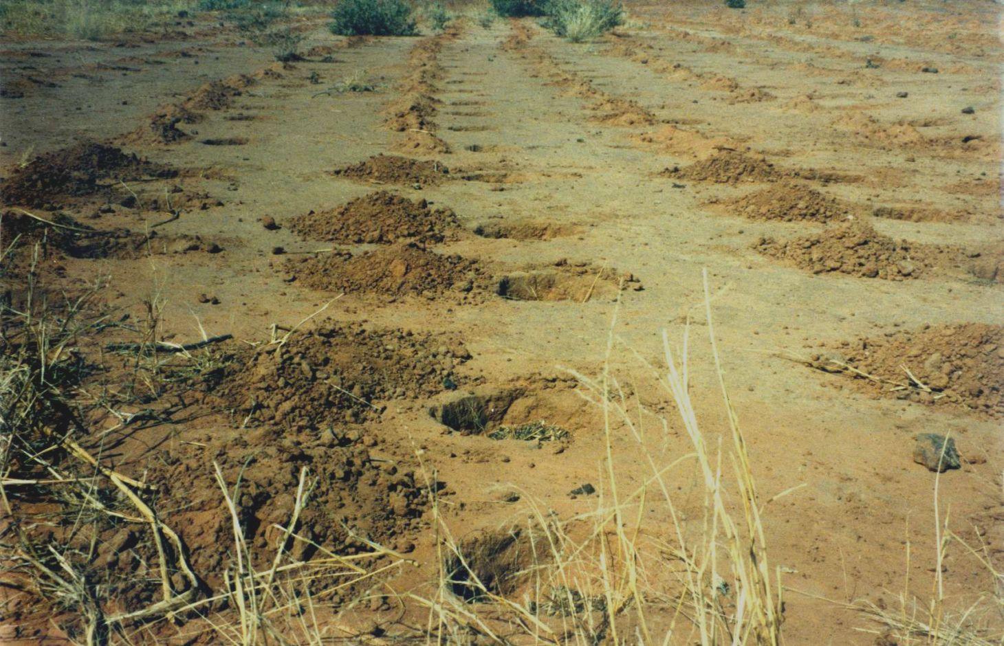
Zai or tassa planting pits are an old farming technique rediscovered after the great drought of 1973/74 and later perfected by development partners working with the farmers. It involves digging planting pits with a diameter of at least 30 to 40 cm and 10 to 15 cm deep. They are spaced 70 to 80 cm apart, resulting in around 10,000 pits per hectare. Staggered rows of holes are dug perpendicularly to the slope. The earth dug out of the hole is piled up to form a small ridge around the rim, which captures water. A couple of handfuls of organic fertiliser or compost are put into each pit. They are normally made in the dry season before the first rains start. However, it is recommended that the pits be made immediately after the rainy season, when the soil is still moist and the weather is not too hot. If the pits are in place early in the dry season, they act as traps during the windy period in February and March, retaining rich dust carried by the harmattan and wind-blown organic matter. At least 3 tonnes of compost per hectare is recommended.
Purpose of the Technology: The arrangement of the pits in staggered rows ensures the most efficient collection of rainwater and slows the flow of water over the surface. The zai technique concentrates and conserves nutrients and water near the roots of the plants grown in them. The application of organic fertiliser directly around the plants is an economical use of a factor of production to which most farmers have limited access. It also reactivates biological activity, increases fertility and loosens the soil.
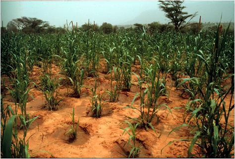
As zai planting pits restore degraded, uncultivated land, they lessen the pressure to clear other land for farming. They also reduce the vulnerability of plants during dry spells and droughts, ensuring crop production and improving food security.
Plots with zai planting pits (with fertiliser) average yields of 409 kg of millet grain per hectare, compared to 195 kg per hectare registered on control plots. Millet yields can therefore be doubled with this technique.
Establishment / maintenance activities and inputs: The zai technique requires high labour input. It is estimated that between 40 and 60 man-days per hectare are required, depending on the density of the pits. There is a mechanised system for making the holes, using a special animal-drawn plough, which considerably reduces the number of man-days required to 7 per hectare.
If the pits are prepared each year or once every two years (using the same pits or making new ones in the spaces between the old ones), soil fertility is restored and the crop cycle can be resumed. The application of organic fertiliser in sufficient quantities enables the plot to be cultivated sustainably. After five years, it can be farmed in the normal way.
Covering extensive areas with zai planting pits requires a high level of community mobilisation and effective organisation and logistics. Apart from this, the technique is very simple to implement and easily mastered by the farmers.
Natural / human environment: Zai planting pits are used on marginal or degraded land that is no longer cultivated, such as low-gradient pediments and land with encrusted soil in areas with rainfall levels of less than 800 mm a year. They are not recommended for sandy soils, as they are not stable when dug in this type of soil, or for valley bottoms, where they risk being flooded. Zai planting pits are particularly useful in areas where land use pressure is high, as they permit the rehabilitation of unproductive land for farming.
From the point of view of climate change adaptation, zai planting pits are particularly useful in areas with erratic or low rainfall, as they prevent the loss of water. As the fertiliser is placed inside the pits, it is not washed away by heavy rain.
2.3 รูปภาพของเทคโนโลยี
อัลบั้มสื่อบันทึก
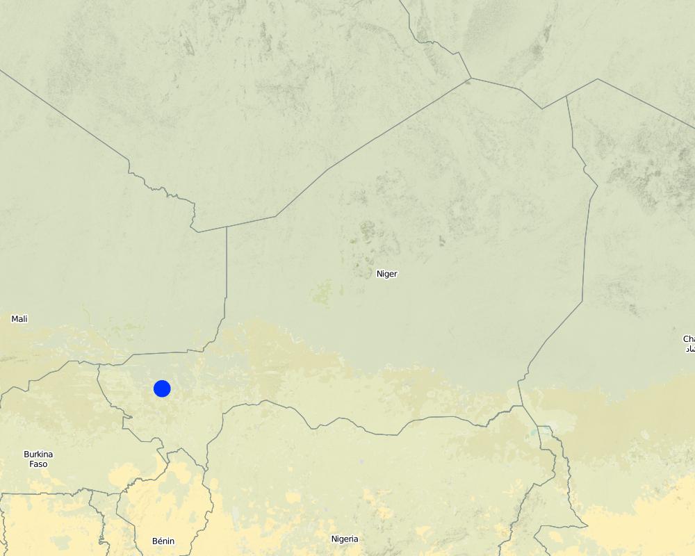
2.5 ประเทศภูมิภาค หรือสถานที่ตั้งที่เทคโนโลยีได้นำไปใช้และได้รับการครอบคลุมโดยการประเมินนี้
ประเทศ:
ไนเจอร์
ภูมิภาค/รัฐ/จังหวัด:
Niger
ข้อมูลจำเพาะเพิ่มเติมของสถานที่ตั้ง :
Regions of Tillabéri, Filingué, Ouallam, Téra and Tahuoa
Map
×2.6 วันที่การดำเนินการ
ถ้าไม่รู้ปีที่แน่นอน ให้ระบุวันที่โดยประมาณ:
- 10-50 ปี
2.7 คำแนะนำของเทคโนโลยี
ให้ระบุว่าเทคโนโลยีถูกแนะนำเข้ามาอย่างไร:
- ทางโครงการหรือจากภายนอก
ความคิดเห็น (ประเภทของโครงการ เป็นต้น) :
developed, implemented and disseminated as part of projects and programmes undertaken from the 1980s onwards to combat desertification and improve natural resource management. Implemented by GIZ (German Federal Enterprise for International Cooperation), PDRT (Projet de développement rural de Tahoua - Tahoua Rural Development Project), PASP (Projet de protection intégrée des ressources agro-sylvo-pastorales Tillabéri-Nord - Project for the Integrated Protection of Agricultural, Forest and Rangeland Resources in Tillabéri-Nord)
3. การจัดประเภทของเทคโนโลยี SLM
3.1 วัตถุประสงค์หลักของเทคโนโลยี
- ปรับปรุงการผลิตให้ดีขึ้น
- สร้างผลกระทบทางด้านเศรษฐกิจที่เป็นประโยชน์
3.2 ประเภทของการใช้ที่ดินในปัจจุบันที่ได้นำเทคโนโลยีไปใช้
Land use mixed within the same land unit:
ใช่
Specify mixed land use (crops/ grazing/ trees):
- การปลูกพืชร่วมกับปศุสัตว์และการทำป่าไม้ (Agro-silvopastoralism)

พื้นที่ปลูกพืช
- การปลูกพืชล้มลุกอายุปีเดียว
- การปลูกไม้ยืนต้น ไม้พุ่ม
Annual cropping - Specify crops:
- oilseed crops - groundnuts
- cereals - millet
- cereals - sorghum
- legumes and pulses - peas
Tree and shrub cropping - Specify crops:
- mango, mangosteen, guava
จำนวนของฤดูเพาะปลูกต่อปี:
- 1
ระบุ:
Longest growing period in days: 120, Longest growing period from month to month: August to October

ทุ่งหญ้าเลี้ยงสัตว์
Extensive grazing:
- การเลี้ยงสัตว์แบบเร่ร่อนไปตามที่ต่าง ๆ (Nomadism)
- กึ่งโนแมนดิซึ่มหรือแพสโตแรลลิซึ่ม (Semi-nomadism/pastoralism)
ทุ่งหญ้าเลี้ยงสัตว์ที่มีการจัดการแบบเข้มข้นหรือการผลิตอาหารสัตว์:
- ตัดแล้วขนไป / ไม่มีการปล่อยแทะเล็มเอง (Cut-and-carry / zero grazing)
- ทุ่งหญ้าเลี้ยงสัตว์ที่ได้มีการปรับปรุง (Improved pastures)

ป่า/พื้นที่ทำไม้
- ป่ากึ่งธรรมชาติ / พื้นที่ทำไม้
(Semi-)natural forests/ woodlands: Specify management type:
- การตัดไม้ที่มีคัดเลือก (Selective felling)
- การตัดหมด (Clear felling)
ผลิตภัณฑ์และบริการ:
- ไม้ซุง
- ไม้ที่นำมาทำเป็นเชื้อเพลิง
- ผลไม้และถั่ว
- ผลิตภัณฑ์อื่น ๆ จากป่า
- การแทะเล็มหญ้า / การเก็บกินหญ้า
แสดงความคิดเห็น:
Major cash crop: Ground nut
Major food crop: Millet
Major other crops: Sorghum, cow pea and mangos
Major land use problems (compiler’s opinion): soil erosion, fertility decline, aridification, loss of limited rainwater by runoff
Type of cropping system and major crops comments: farmers are mainly agropastoralists with some communities specialised on pure pastoralism
Constraints of forested government-owned land or commons
Type of grazing land: Extensive grazing: Nomadism, semi-nomadism/pastoralism. Intensive grazing: Cut-and-carry/zero grazing and improved pasture
Livestock density: 1-10 LU / km2
3.4 การใช้น้ำ
การใช้น้ำของที่ดินที่มีการใช้เทคโนโลยีอยู่:
- จากน้ำฝน
3.5 กลุ่ม SLM ที่ตรงกับเทคโนโลยีนี้
- การรบกวนดินให้น้อยที่สุด
- การจัดการความอุดมสมบรูณ์ของดินแบบผสมผสาน
3.6 มาตรการ SLM ที่ประกอบกันเป็นเทคโนโลยี

มาตรการจัดการพืช
- A2: อินทรียวัตถุในดิน/ความอุดมสมบูรณ์ในดิน

มาตรการอนุรักษ์ด้วยโครงสร้าง
- S4: คูน้ำแนวระดับ หลุม
3.7 รูปแบบหลักของการเสื่อมโทรมของที่ดินที่ได้รับการแก้ไขโดยเทคโนโลยี

การกัดกร่อนของดินโดยน้ำ
- Wt (Loss of topsoil): การสูญเสียดินชั้นบนหรือการกัดกร่อนที่ผิวดิน

การกัดกร่อนของดินโดยลม
- Et (Loss of topsoil): การสูญเสียดินชั้นบน

การเสื่อมโทรมของดินทางด้านเคมี
- Cn (Fertility decline): ความอุดมสมบูรณ์และปริมาณอินทรียวัตถุในดินถูกทำให้ลดลงไป (ไม่ได้เกิดจากสาเหตุการกัดกร่อน)

การเสื่อมโทรมของดินทางด้านชีวภาพ
- Bc (Reduction of vegetation cover): การลดลงของจำนวนพืชที่ปกคลุมดิน

การเสื่อมโทรมของน้ำ
- Ha (Aridification): การเกิดความแห้งแล้ง
แสดงความคิดเห็น:
Main causes of degradation: soil management (Unadapted landuse methods, reduced or abandoned fallow periods), crop management (annual, perennial, tree/shrub) (Neglect of fallow periods and crop rotation), droughts (due to heat waves), population pressure (rapidly growing population increasing pressure on land), land tenure (insecure access to land and collectively managed communal land), poverty / wealth (very poor population)
Secondary causes of degradation: deforestation / removal of natural vegetation (incl. forest fires) (deforestation through overgrazing and fire wood collection), over-exploitation of vegetation for domestic use (firewood collection), overgrazing (cattle, sheep and goats), change in temperature (Climate change: heat waves), change of seasonal rainfall (more variable onset of rain), Heavy / extreme rainfall (intensity/amounts) (more variable and intensive rains), wind storms / dust storms (frequent storms), floods (due to intensive rain storms), labour availability (some migration of men to nearby cities), education, access to knowledge and support services (high level of illiteracy)
3.8 การป้องกัน การลดลง หรือการฟื้นฟูความเสื่อมโทรมของที่ดิน
ระบุเป้าหมายของเทคโนโลยีกับความเสื่อมโทรมของที่ดิน:
- ฟื้นฟูบำบัดที่ดินที่เสื่อมโทรมลงอย่างมาก
4. ข้อมูลจำเพาะด้านเทคนิค กิจกรรมการนำไปปฏิบัติใช้ ปัจจัยนำเข้า และค่าใช้จ่าย
4.1 แบบแปลนทางเทคนิคของเทคโนโลยี
ข้อมูลจำเพาะด้านเทคนิค (แบบแปลนทางเทคนิคของเทคโนโลยี):
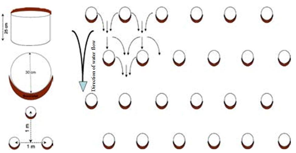
It involves digging planting pits with a diameter of at least 30 to 40 cm and 10 to 15 cm deep. They are spaced 70 to 80 cm apart, resulting in around 10,000 pits per hectare. Staggered rows of holes are dug perpendicularly to the slope. The earth dug out of the hole is piled up to form a small ridge around the rim, which captures water. A couple of handfuls of organic fertiliser or compost are put into each pit.
Location: Niger
Technical knowledge required for field staff / advisors: moderate
Technical knowledge required for land users: low
Main technical functions: control of dispersed runoff: retain / trap, control of dispersed runoff: impede / retard, control of concentrated runoff: retain / trap, control of concentrated runoff: impede / retard, increase in organic matter, increase in nutrient availability (supply, recycling,…), increase of infiltration, increase / maintain water stored in soil, water harvesting / increase water supply, sediment retention / trapping, sediment harvesting
Secondary technical functions: improvement of ground cover, stabilisation of soil (eg by tree roots against land slides), reduction in wind speed
Retention/infiltration ditch/pit, sediment/sand trap
Spacing between structures (m): 0.7-0.8
Depth of ditches/pits/dams (m): 0.15
Length of ditches/pits/dams (m): 0.3-0.4
ผู้เขียน:
PASP
4.2 ข้อมูลทั่วไปเกี่ยวกับการคำนวณปัจจัยนำเข้าและค่าใช้จ่าย
อื่นๆ หรือสกุลเงินประจำชาติ (ระบุ):
CFA Franc
4.3 กิจกรรมเพื่อการจัดตั้ง
| กิจกรรม | Timing (season) | |
|---|---|---|
| 1. | marking out the rows perpendicular to the slope | |
| 2. | digging pits in staggered rows | |
| 3. | forming a ridge on the downhill side | |
| 4. | A couple of handfuls of organic fertiliser or compost are put into each pit |
4.4 ค่าใช้จ่ายของปัจจัยนำเข้าที่จำเป็นสำหรับการจัดตั้ง
| ปัจจัยนำเข้า | หน่วย | ปริมาณ | ค่าใช้จ่ายต่อหน่วย | ค่าใช้จ่ายทั้งหมดต่อปัจจัยนำเข้า | %ของค่าใช้จ่ายที่ก่อให้เกิดขึ้นโดยผู้ใช้ที่ดิน | |
|---|---|---|---|---|---|---|
| แรงงาน | labour | 1.0 | 16.3 | 16.3 | ||
| แรงงาน | transport and planting trees | 1.0 | 12.3 | 12.3 | ||
| อุปกรณ์ | machine use | 1.0 | 23.6 | 23.6 | ||
| วัสดุด้านพืช | seedlings | |||||
| ค่าใช้จ่ายทั้งหมดของการจัดตั้งเทคโนโลยี | 52.2 | |||||
| Total costs for establishment of the Technology in USD | 52.2 | |||||
4.5 การบำรุงรักษาสภาพหรือกิจกรรมที่เกิดขึ้นเป็นประจำ
| กิจกรรม | ช่วงระยะเวลา/ความถี่ | |
|---|---|---|
| 1. | the pits are prepared each year or once every two years (using the same pits or making new ones in the spaces between the old ones | |
| 2. | applying organic fertiliser every two years (1 to 2 hand-fuls per pit, amounting to around 3 tonnes per hectare). |
4.7 ปัจจัยสำคัญที่สุดที่มีผลกระทบต่อค่าใช้จ่าย
ปัจจัยสำคัญที่สุดที่มีผลกระทบต่อค่าใช้จ่ายต่างๆ:
Labour: 40 to 60 man-days per hectare
• marking out the rows perpendicular to the slope
• digging pits in staggered rows
• forming a ridge on the downhill side
• applying organic fertiliser every two years (1 to 2 handfuls per pit, amounting to around 3 tonnes per hectare).
Other costs: transportation of 30 cartloads of manure.
5. สิ่งแวดล้อมทางธรรมชาติและของมนุษย์
5.1 ภูมิอากาศ
ฝนประจำปี
- < 250 ม.ม.
- 251-500 ม.ม.
- 501-750 ม.ม.
- 751-1,000 ม.ม.
- 1,001-1,500 ม.ม.
- 1,501-2,000 ม.ม.
- 2,001-3,000 ม.ม.
- 3,001-4,000 ม.ม.
- > 4,000 ม.ม.
เขตภูมิอากาศเกษตร
- กึ่งแห้งแล้ง
Thermal climate class: subtropics
5.2 สภาพภูมิประเทศ
ค่าเฉลี่ยความลาดชัน:
- ราบเรียบ (0-2%)
- ลาดที่ไม่ชัน (3-5%)
- ปานกลาง (6-10%)
- เป็นลูกคลื่น (11-15%)
- เป็นเนิน (16-30%)
- ชัน (31-60%)
- ชันมาก (>60%)
ธรณีสัณฐาน:
- ที่ราบสูง/ที่ราบ
- สันเขา
- ไหล่เขา
- ไหล่เนินเขา
- ตีนเนิน
- หุบเขา
ระดับความสูง:
- 0-100 เมตร
- 101-500 เมตร
- 501-1,000 เมตร
- 1,001-1,500 เมตร
- 1,501-2,000 เมตร
- 2,001-2,500 เมตร
- 2,501-3,000 เมตร
- 3,001-4,000 เมตร
- > 4,000 เมตร
5.3 ดิน
ค่าเฉลี่ยความลึกของดิน:
- ตื้นมาก (0-20 ซ.ม.)
- ตื้น (21-50 ซ.ม.)
- ลึกปานกลาง (51-80 ซ.ม.)
- ลึก (81-120 ซ.ม.)
- ลึกมาก (>120 ซ.ม.)
เนื้อดิน (ดินชั้นบน):
- ปานกลาง (ดินร่วน ทรายแป้ง)
- ละเอียด/หนัก (ดินเหนียว)
อินทรียวัตถุในดิน:
- ต่ำ (<1%)
(ถ้ามี) ให้แนบคำอธิบายเรื่องดินแบบเต็มหรือระบุข้อมูลที่มีอยู่ เช่น ชนิดของดิน ค่า pH ของดินหรือความเป็นกรดของดิน ความสามารถในการแลกเปลี่ยนประจุบวก ไนโตรเจน ความเค็ม เป็นต้น:
Soil texture: Fine to medium (sandy to clayey loams)
Soil fertility: Very low to medium
Soil drainage/infiltration: Poor and medium (ranked 2)
Soil water storage capacity: Low and medium (ranked 2)
5.4 ความเป็นประโยชน์และคุณภาพของน้ำ
ระดับน้ำใต้ดิน:
5-50 เมตร
น้ำไหลบ่าที่ผิวดิน:
ปานกลาง
คุณภาพน้ำ (ที่ยังไม่ได้บำบัด):
เป็นน้ำใช้เพื่อการเกษตรเท่านั้น (การชลประทาน)
5.5 ความหลากหลายทางชีวภาพ
ความหลากหลายทางชนิดพันธุ์:
- ต่ำ
5.6 ลักษณะของผู้ใช้ที่ดินที่นำเทคโนโลยีไปปฏิบัติใช้
แนวทางการตลาดของระบบการผลิต:
- เพื่อการยังชีพ (หาเลี้ยงตนเอง)
ระดับของความมั่งคั่งโดยเปรียบเทียบ:
- ยากจนมาก
- จน
ระดับของการใช้เครื่องจักรกล:
- งานที่ใช้แรงกาย
- การใช้กำลังจากสัตว์
เพศ:
- ชาย
ระบุลักษณะอื่นๆที่เกี่ยวข้องของผู้ใช้ที่ดิน:
Population density: 10-50 persons/km2
Annual population growth: 3% - 4% (mostly poor households below poverty line).
Off-farm income specification: men migrate temporarily or permanently to cities for off-farm income, women and men seasonally carry out paid farm work
Market orientation of production system: subsistence (self-supply, Most households crop for subsistence, mainly for small agropastoralists ), mixed (subsistence/commercial, crop surplus is sold on market, medium agropastoralists) and commercial market (Some vegetable growing, pastoralists)
Level of mechanization: Menual work (ranked 1) and animal traction (ranked 2, ox, donkey)
5.7 Average area of land used by land users applying the Technology
- < 0.5 เฮกตาร์
- 0.5-1 เฮกตาร์
- 1-2 เฮกตาร์
- 2-5 เฮกตาร์
- 5-15 เฮกตาร์
- 15-50 เฮกตาร์
- 50-100 เฮกตาร์
- 100-500 เฮกตาร์
- 500-1,000 เฮกตาร์
- 1,000-10,000 เฮกตาร์
- >10,000 เฮกตาร์
พิจารณาว่าเป็นขนาดเล็ก กลาง หรือขนาดใหญ่ (ซึ่งอ้างอิงถึงบริบทระดับท้องถิ่น):
- ขนาดเล็ก
5.8 กรรมสิทธิ์ในที่ดิน สิทธิในการใช้ที่ดินและสิทธิในการใช้น้ำ
แสดงความคิดเห็น:
traditional land use rights prevail. On fields individual land use rights, communal rights on pasture and forest land (collection of wood and other products (fruits, medicinal plants))
5.9 การเข้าถึงบริการและโครงสร้างพื้นฐาน
สุขภาพ:
- จน
- ปานกลาง
- ดี
การศึกษา:
- จน
- ปานกลาง
- ดี
ความช่วยเหลือทางด้านเทคนิค:
- จน
- ปานกลาง
- ดี
การจ้างงาน (เช่น ภายนอกฟาร์ม):
- จน
- ปานกลาง
- ดี
ตลาด:
- จน
- ปานกลาง
- ดี
พลังงาน:
- จน
- ปานกลาง
- ดี
ถนนและการขนส่ง:
- จน
- ปานกลาง
- ดี
น้ำดื่มและการสุขาภิบาล:
- จน
- ปานกลาง
- ดี
บริการด้านการเงิน:
- จน
- ปานกลาง
- ดี
6. ผลกระทบและสรุปคำบอกกล่าว
6.1 ผลกระทบในพื้นที่ดำเนินการ (On-site) จากการใช้เทคโนโลยี
ผลกระทบทางด้านเศรษฐกิจและสังคม
การผลิต
การผลิตพืชผล
การเสี่ยงต่อความล้มเหลวในการผลิต
พื้นที่สำหรับการผลิต
รายได้และค่าใช้จ่าย
รายได้จากฟาร์ม
ภาระงาน
ผลกระทบด้านสังคมวัฒนธรรมอื่น ๆ
ความมั่นคงด้านอาหาร / พึ่งตนเองได้
SLM หรือความรู้เรื่องความเสื่อมโทรมของที่ดิน
Improved livelihoods and human well-being
แสดงความคิดเห็น/ระบุ:
Plots with zai planting pits (with fertiliser) average yields of 409 kg of millet grain per hectare, compared to 195 kg per hectare registered on control plots. Millet yields can therefore be doubled with this technique. They also reduce the vulnerability of plants during dry spells and droughts, ensuring crop production and improving food security.
ผลกระทบด้านนิเวศวิทยา
วัฐจักรน้ำหรือน้ำบ่า
น้ำไหลบ่าที่ผิวดิน
ดิน
ความชื้นในดิน
สิ่งปกคลุมดิน
การหมุนเวียนและการเติมของธาตุอาหาร
อินทรียวัตถุในดิน/ต่ำกว่าดินชั้น C
ความหลากหลายทางชีวภาพของพืชและสัตว์
ความหลากหลายทางชีวภาพของพืช
ลดความเสี่ยงของภัยพิบัติ
ความเร็วของลม
ผลกระทบด้านนิเวศวิทยาอื่น ๆ
Waterlogging in planting pits after heavy rains
6.2 ผลกระทบนอกพื้นที่ดำเนินการ (Off-site) จากการใช้เทคโนโลยี
น้ำท่วมพื้นที่ท้ายน้ำ
การทับถมของดินตะกอนพื้นที่ท้ายน้ำ
6.3 การเผชิญและความตอบสนองของเทคโนโลยีต่อการเปลี่ยนแปลงสภาพภูมิอากาศที่ค่อยเป็นค่อยไป และสภาพรุนแรงของภูมิอากาศ / ภัยพิบัติ (ที่รับรู้ได้โดยผู้ใช้ที่ดิน)
การเปลี่ยนแปลงสภาพภูมิอากาศที่ค่อยเป็นค่อยไป
การเปลี่ยนแปลงสภาพภูมิอากาศที่ค่อยเป็นค่อยไป
| ฤดู | increase or decrease | เทคโนโลยีมีวิธีการรับมืออย่างไร | |
|---|---|---|---|
| อุณหภูมิประจำปี | เพิ่มขึ้น | ดี |
สภาพรุนแรงของภูมิอากาศ (ภัยพิบัติ)
ภัยพิบัติทางอุตุนิยมวิทยา
| เทคโนโลยีมีวิธีการรับมืออย่างไร | |
|---|---|
| พายุฝนประจำท้องถิ่น | ไม่ค่อยดี |
| พายุลมประจำท้องถิ่น | ดี |
ภัยพิบัติจากสภาพภูมิอากาศ
| เทคโนโลยีมีวิธีการรับมืออย่างไร | |
|---|---|
| ภัยจากฝนแล้ง | ดี |
ภัยพิบัติจากน้ำ
| เทคโนโลยีมีวิธีการรับมืออย่างไร | |
|---|---|
| น้ำท่วมตามปกติ (แม่น้ำ) | ไม่ค่อยดี |
ผลลัพธ์ตามมาที่เกี่ยวข้องกับภูมิอากาศอื่น ๆ
ผลลัพธ์ตามมาที่เกี่ยวข้องกับภูมิอากาศอื่น ๆ
| เทคโนโลยีมีวิธีการรับมืออย่างไร | |
|---|---|
| ช่วงการปลูกพืชที่ลดลงมา | ไม่ทราบ |
6.4 การวิเคราะห์ค่าใช้จ่ายและผลประโยชน์ที่ได้รับ
ผลประโยชน์ที่ได้รับเปรียบเทียบกับค่าใช้จ่ายในการจัดตั้งเป็นอย่างไร (จากมุมมองของผู้ใช้ที่ดิน)
ผลตอบแทนระยะสั้น:
ด้านบวก
ผลตอบแทนระยะยาว:
ด้านบวกอย่างมาก
ผลประโยชน์ที่ได้รับเปรียบเทียบกับค่าใช้จ่ายในการบำรุงรักษาหรือต้นทุนที่เกิดขึ้นซ้ำอีก เป็นอย่างไร (จากมุมมองของผู้ใช้ที่ดิน)
ผลตอบแทนระยะสั้น:
ด้านบวกอย่างมาก
ผลตอบแทนระยะยาว:
ด้านบวกอย่างมาก
6.7 จุดแข็ง / ข้อได้เปรียบ / โอกาสของเทคโนโลยี
| จุดแข็ง / ข้อได้เปรียบ / โอกาสในทัศนคติของผู้รวบรวมหรือวิทยากรหลัก |
|---|
| The arrangement of the pits in staggered rows ensures the most efficient collection of rainwater and slows the flow of water over the surface. The zai technique concentrates and conserves nutrients and water near the roots of the plants grown in them. |
| Zai planting pits are particularly useful in areas where land use pressure is high, as they permit the rehabilitation of unproductive land for farming. Therefore they lessen the pressure to clear other land for farming. |
| They also reduce the vulnerability of plants during dry spells and droughts, ensuring crop production and im- proving food security. |
| It permits a rational use of fertiliser. When fertiliser is spread on the surface of a plot without zai planting pits, it can be washed away by runoff. |
| very simple to implement and easily mastered by the farmers |
6.8 จุดอ่อน / ข้อเสียเปรียบ / ความเสี่ยงของเทคโนโลยีและวิธีการแก้ไข
| จุดอ่อน / ข้อเสียเปรียบ / ความเสี่ยงในทัศนคติของผู้รวบรวมหรือวิทยากรหลัก | มีวิธีการแก้ไขได้อย่างไร |
|---|---|
| The zai technique requires high labour input. | |
| Zai planting pits are not recommended for light soils, as they fill in too quickly |
7. การอ้างอิงและการเชื่อมต่อ
7.1 วิธีการและแหล่งข้อมูล
- ไปเยี่ยมชมภาคสนาม การสำรวจพื้นที่ภาคสนาม
- การสัมภาษณ์กับผู้ใช้ที่ดิน
วันที่เก็บรวบรวมข้อมูล(ภาคสนาม) :
01/07/2012
7.3 Links to relevant online information
ชื่อเรื่องหรือคำอธิบาย:
Good Practices in Soil and Water Conservation. A contribution to adaptation and farmers´ resilience towards climate change in the Sahel. Published by GIZ in 2012.
URL:
http://agriwaterpedia.info/wiki/Main_Page
ลิงก์และโมดูล
ขยายทั้งหมด ย่อทั้งหมดลิงก์
ไม่มีลิงก์
โมดูล
ไม่มีโมดูล