Shelterbelts for farmland in sandy areas [จีน]
- ผู้สร้างสรรค์:
- การอัพเดท:
- ผู้รวบรวม: Meili WEN
- ผู้เรียบเรียง: –
- ผู้ตรวจสอบ: David Streiff, Deborah Niggli, Alexandra Gavilano
Farmland shelter belt
technologies_1366 - จีน
ดูส่วนย่อย
ขยายทั้งหมด ย่อทั้งหมด1. ข้อมูลทั่วไป
1.2 รายละเอียดที่ติดต่อได้ของผู้รวบรวมและองค์กรที่เกี่ยวข้องในการประเมินและการจัดเตรียมทำเอกสารของเทคโนโลยี
ผู้เชี่ยวชาญ SLM:
Wang Dogmei
จีน
ชื่อของโครงการซึ่งอำนวยความสะดวกในการทำเอกสารหรือการประเมินเทคโนโลยี (ถ้าเกี่ยวข้อง)
Book project: where the land is greener - Case Studies and Analysis of Soil and Water Conservation Initiatives Worldwide (where the land is greener)ชื่อขององค์กรซึ่งอำนวยความสะดวกในการทำเอกสารหรือการประเมินเทคโนโลยี (ถ้าเกี่ยวข้อง)
GEF/OP12 Gansu Project (GEF/OP12 Gansu Project) - จีน1.3 เงื่อนไขการใช้ข้อมูลที่ได้บันทึกผ่านทาง WOCAT
ผู้รวบรวมและวิทยากรหลักยอมรับเงื่อนไขเกี่ยวกับการใช้ข้อมูลที่ถูกบันทึกผ่านทาง WOCAT:
ใช่
1.5 Reference to Questionnaire(s) on SLM Approaches (documented using WOCAT)
Shelter Belt [จีน]
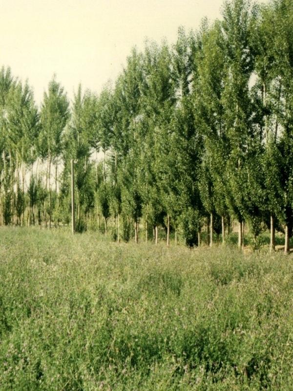
The shelter belt is a strip or a row of trees planted in a farmland as a wind barrier to protect crops and reduce wind erosion.
- ผู้รวบรวม: Meili WEN
2. การอธิบายลักษณะของเทคโนโลยี SLM
2.1 การอธิบายแบบสั้น ๆ ของเทคโนโลยี
คำจำกัดความของเทคโนโลยี:
Belts of trees, planted in a rectangular grid pattern or in strips within, and on the periphery of, farmland to act as windbreaks.
2.2 การอธิบายแบบละเอียดของเทคโนโลยี
คำอธิบาย:
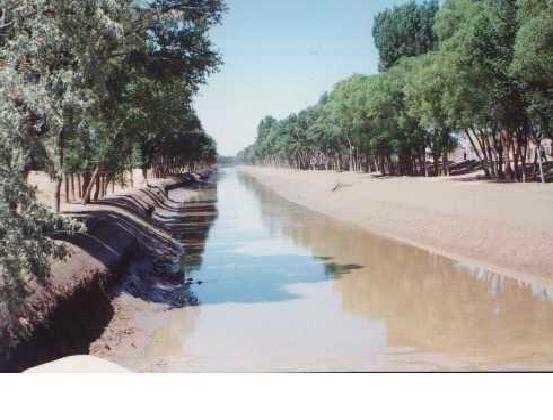
Shelterbelts to protect cropland are a specific type of agroforestry system comprising certain tall growing tree species. Such shelterbelts around farmland help reduce natural hazards including sandstorms, wind erosion, shifting sand, droughts and frost. They also improve the microclimate (reduced temperature, wind speed, soil water loss and excessive wind-induced transpiration) and create more favourable conditions for crop production. Thus the establishment of shelterbelts plays a crucial role in the sandy drylands that are affected by wind and resultant desertification
especially during winter and spring. Where there is irrigation, the shelterbelts protect the infrastructure from silting-up with wind-borne sediment.
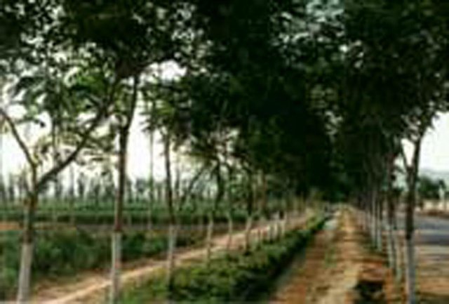
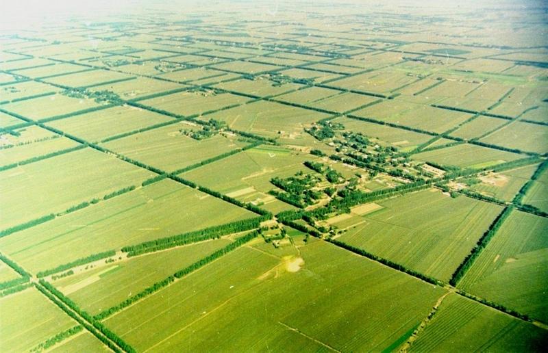
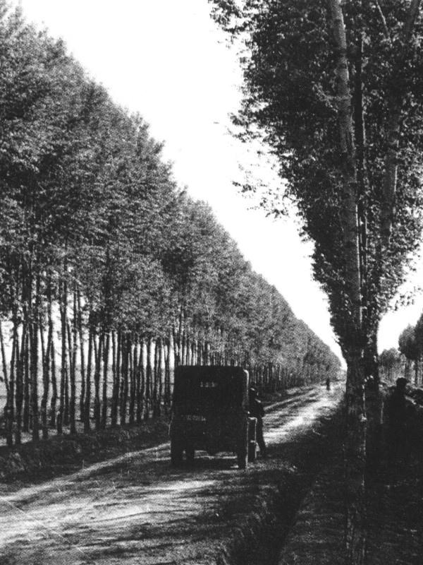
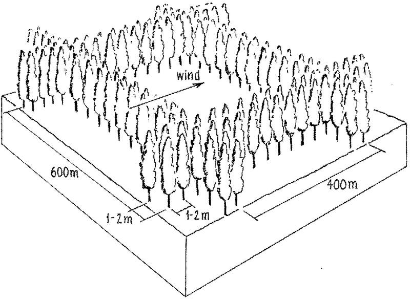
Strips of tall growing species (15-25 m) of poplar (Populus spp.) or willow (Salix spp.) were originally (from 1960s onwards) planted in a 400 by 600 m rectangular grid pattern within extensive areas of cropland, with an extra belt of windbreaks on the windward side (against the prevailing wind). Generally, the distance effectively protected is 15-25 times the tree height. Strips are of variable width, consisting of 2-5 tree lines (1-3 m apart) with trees planted every 1-2 m within the lines. Selective felling is used to maintain adequate growing space and the protective effect of the trees.
The impact of the shelterbelts depends on the planting pattern of the trees (the format of strips and grids), the orientation of the shelterbelts in relation to the wind, the spacing between, and the width of each strip and the type of trees planted. The specific design is primarily based on preventing the negative effects of wind, but depends also on local conditions such as the layout of the land, the location of the roads, farm boundaries and irrigation canals. Ideally the tree strips are perpendicular to the prevailing wind direction, and the angle between the strip and the prevailing wind is never less than 45 degrees. The structure of the strips determines the way the wind is controlled, ranging from blocking the wind
to letting it diffuse through semi-permeable shelterbelts. The best effect is achieved if the wind is not blocked entirely, as this can cause turbulence.
The ownership of the land and the shelterbelts still rests with the state, but management has been more and more transferred to individual households. On condition that the impact of the shelterbelt is not affected, the local forestry agencies now allow some felling of mature trees - on a rotational and selective basis, for timber and firewood. Pine trees (Pinus sylvestris var. mongolica and P. tabulaeformis), which command high value as timber for construction, and fruit (and cash) trees like the apricot tree (Prunus armeniace) are increasingly used.
2.3 รูปภาพของเทคโนโลยี
อัลบั้มสื่อบันทึก
2.5 ประเทศภูมิภาค หรือสถานที่ตั้งที่เทคโนโลยีได้นำไปใช้และได้รับการครอบคลุมโดยการประเมินนี้
ประเทศ:
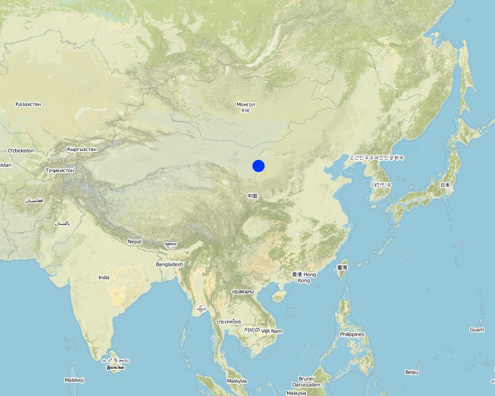
จีน
ภูมิภาค/รัฐ/จังหวัด:
Inner Mongolia Autonomous Region
ระบุการกระจายตัวของเทคโนโลยี:
- กระจายไปอย่างสม่ำเสมอในพื้นที่
If the Technology is evenly spread over an area, specify area covered (in km2):
500.0
If precise area is not known, indicate approximate area covered:
- 100-1,000 ตร.กม.
แสดงความคิดเห็น:
Total area covered by the SLM Technology is 500 km2.
Total SWC Technology area is not clear. This technology area data is from Inner Mongolia forest department. Inner Mongolia autonomy region forest statistic data, 1987, P75. Technology beginning year is from: Water and soil conservation bureau, Yellow River irrigation works committee of Department of water and electricity. Water and soil conservation economy benefit thesis collecting,1987, P45-47.
Map
×2.6 วันที่การดำเนินการ
ถ้าไม่รู้ปีที่แน่นอน ให้ระบุวันที่โดยประมาณ:
- มากกว่า 50 ปี (แบบดั้งเดิม)
2.7 คำแนะนำของเทคโนโลยี
ให้ระบุว่าเทคโนโลยีถูกแนะนำเข้ามาอย่างไร:
- ทางโครงการหรือจากภายนอก
ความคิดเห็น (ประเภทของโครงการ เป็นต้น) :
USA and domestic.
3. การจัดประเภทของเทคโนโลยี SLM
3.1 วัตถุประสงค์หลักของเทคโนโลยี
- ลดความเสี่ยงของภัยพิบัติ
- ปรับตัวเข้ากับการเปลี่ยนแปลงภูมิอากาศของโลก สภาพภูมิอากาศที่รุนแรงและผลกระทบ
3.2 ประเภทของการใช้ที่ดินในปัจจุบันที่ได้นำเทคโนโลยีไปใช้
Land use mixed within the same land unit:
ใช่
Specify mixed land use (crops/ grazing/ trees):
- วนเกษตร (Agroforestry)

พื้นที่ปลูกพืช
- การปลูกพืชล้มลุกอายุปีเดียว
Annual cropping - Specify crops:
- cereals - maize
- wheat
จำนวนของฤดูเพาะปลูกต่อปี:
- 1
ระบุ:
Longest growing period in days: 150Longest growing period from month to month: May - Sep

ป่า/พื้นที่ทำไม้
- ป่ากึ่งธรรมชาติ / พื้นที่ทำไม้
- ป่า/พื้นที่ทำไม้
(Semi-)natural forests/ woodlands: Specify management type:
- การตัดไม้ที่มีคัดเลือก (Selective felling)
Type of tree:
- Pinus species
- Populus species
- Salix spp
ผลิตภัณฑ์และบริการ:
- ไม้ซุง
- ไม้ที่นำมาทำเป็นเชื้อเพลิง
- ผลไม้และถั่ว
- การป้องกันภัยธรรมชาติ
แสดงความคิดเห็น:
Trees/ shrubs species: Poplars (Populus spp.), willows (Salix spp.), increasingly also pine (Pinus sylvestris var. Mongolic
Major land use problems (compiler’s opinion): Strong winds in the winter and spring result in serious natural hazards including sand storms, sand encroachment and wind erosion, while dry and hot winds in the summer increase transpiration leading to plant stress and reduced crop yields.
Major land use problems (land users’ perception): Low yield and intensive wind blow in winter and spring.
3.3 Has land use changed due to the implementation of the Technology?
Has land use changed due to the implementation of the Technology?
- Yes (Please fill out the questions below with regard to the land use before implementation of the Technology)
พื้นที่ปลูกพืช
- การปลูกพืชล้มลุกอายุปีเดียว
3.4 การใช้น้ำ
การใช้น้ำของที่ดินที่มีการใช้เทคโนโลยีอยู่:
- น้ำฝนร่วมกับการชลประทาน
3.5 กลุ่ม SLM ที่ตรงกับเทคโนโลยีนี้
- การปลูกป่าร่วมกับพืช
- แนวกันลมหรือแนวต้านลม
3.6 มาตรการ SLM ที่ประกอบกันเป็นเทคโนโลยี

มาตรการอนุรักษ์ด้วยวิธีพืช
- V1: ต้นไม้และพุ่มไม้คลุมดิน

มาตรการอนุรักษ์ด้วยการจัดการ
- M1: การเปลี่ยนรูปแบบของการใช้ประโยชน์ที่ดิน
แสดงความคิดเห็น:
Main measures: vegetative measures
Type of vegetative measures: aligned: -against wind
3.7 รูปแบบหลักของการเสื่อมโทรมของที่ดินที่ได้รับการแก้ไขโดยเทคโนโลยี

การกัดกร่อนของดินโดยลม
- Et (Loss of topsoil): การสูญเสียดินชั้นบน
- Eo (Offsite degradation effect): ผลกระทบนอกพื้นที่

การเสื่อมโทรมของน้ำ
- Ha (Aridification): การเกิดความแห้งแล้ง
แสดงความคิดเห็น:
Main type of degradation addressed: Et: loss of topsoil, Eo: offsite degradation effects, Ha: aridification
Main causes of degradation: deforestation / removal of natural vegetation (incl. forest fires), poverty / wealth (Lack of captial)
Secondary causes of degradation: overgrazing, education, access to knowledge and support services (Lack of knowledge), Lack of enforcement of legislat./authority
3.8 การป้องกัน การลดลง หรือการฟื้นฟูความเสื่อมโทรมของที่ดิน
ระบุเป้าหมายของเทคโนโลยีกับความเสื่อมโทรมของที่ดิน:
- ลดความเสื่อมโทรมของดิน
แสดงความคิดเห็น:
Main goals: mitigation / reduction of land degradation
4. ข้อมูลจำเพาะด้านเทคนิค กิจกรรมการนำไปปฏิบัติใช้ ปัจจัยนำเข้า และค่าใช้จ่าย
4.1 แบบแปลนทางเทคนิคของเทคโนโลยี
ข้อมูลจำเพาะด้านเทคนิค (แบบแปลนทางเทคนิคของเทคโนโลยี):
Overview of the shelterbelt layout.
Insert 1: Planting scheme: shelterbelts compromise 2-5 tree lines forming the windbreak about 5-15 m wide and 15-25 m high.
Insert 2: Rectangle grid layout of shelterbelts. Spacing of the rows is denser against the prevailing wind.
Technical knowledge required for field staff / advisors: moderate
Technical knowledge required for land users: low
Main technical functions: increase / maintain water stored in soil, reduction in wind speed, protection from wind erosion, protection from sand encroachment, protection of crops from mechanical damage, reduction in evaporation loss
Secondary technical functions: increase in organic matter
Aligned: -against wind
Vegetative material: T : trees / shrubs
Trees/ shrubs species: Poplars (Populus spp.), willows (Salix spp.), increasingly also pine (Pinus sylvestris var. Mongolic)
ผู้เขียน:
Mats Gurtner
4.2 ข้อมูลทั่วไปเกี่ยวกับการคำนวณปัจจัยนำเข้าและค่าใช้จ่าย
ให้ระบุว่าค่าใช้จ่ายและปัจจัยนำเข้าได้รับการคำนวณอย่างไร:
- ต่อพื้นที่ที่ใช้เทคโนโลยี
ระบุขนาดและหน่วยพื้นที่:
ha
ระบุสกุลเงินที่ใช้คำนวณค่าใช้จ่าย:
- USD
ระบุค่าเฉลี่ยของค่าจ้างในการจ้างแรงงานต่อวัน:
1.20
4.3 กิจกรรมเพื่อการจัดตั้ง
| กิจกรรม | Timing (season) | |
|---|---|---|
| 1. | 1 Planning / designing of shelterbelt. | |
| 2. | 2 Selection and collection of trees seedlings. | |
| 3. | 3 Clearing and preparing land for planting of shelterbelt in | late autumn and spring |
| 4. | 3 Clearing and preparing land for planting of shelterbelt in | |
| 5. | 4 Pits for planting the seedlings are dug | 4 Pits for planting the seedlings are dug |
| 6. | 5 Tree seedlings are planted | late spring |
| 7. | 6 After planting each seedling is watered for up to two years. |
4.4 ค่าใช้จ่ายของปัจจัยนำเข้าที่จำเป็นสำหรับการจัดตั้ง
| ปัจจัยนำเข้า | หน่วย | ปริมาณ | ค่าใช้จ่ายต่อหน่วย | ค่าใช้จ่ายทั้งหมดต่อปัจจัยนำเข้า | %ของค่าใช้จ่ายที่ก่อให้เกิดขึ้นโดยผู้ใช้ที่ดิน | |
|---|---|---|---|---|---|---|
| แรงงาน | Mainly collection and planting | ha | 79.0 | 1.2 | 94.8 | |
| อุปกรณ์ | tools | ha | 1.0 | 5.0 | 5.0 | 100.0 |
| วัสดุด้านพืช | tree seedlings | ha | 1.0 | 25.0 | 25.0 | |
| ค่าใช้จ่ายทั้งหมดของการจัดตั้งเทคโนโลยี | 124.8 | |||||
| Total costs for establishment of the Technology in USD | 124.8 | |||||
ถ้าผู้ใช้ที่ดินรับภาระน้อยกว่า 100% ของค่าใช้จ่าย ให้ระบุว่าใครเป็นผู้รับผิดชอบส่วนที่เหลือ:
USA and domestic projects
แสดงความคิดเห็น:
Duration of establishment phase: 36 month(s)
4.5 การบำรุงรักษาสภาพหรือกิจกรรมที่เกิดขึ้นเป็นประจำ
| กิจกรรม | ช่วงระยะเวลา/ความถี่ | |
|---|---|---|
| 1. | Watering | after planting /timely |
| 2. | Pruning of trees. | |
| 3. | Pest and disease control within shelterbelt. | |
| 4. | Intermediate/ selective tree felling. |
4.6 ค่าใช้จ่ายของปัจจัยนำเข้าและกิจกรรมที่เกิดขึ้นเป็นประจำที่ต้องการการบำรุงรักษา (ต่อปี)
| ปัจจัยนำเข้า | หน่วย | ปริมาณ | ค่าใช้จ่ายต่อหน่วย | ค่าใช้จ่ายทั้งหมดต่อปัจจัยนำเข้า | %ของค่าใช้จ่ายที่ก่อให้เกิดขึ้นโดยผู้ใช้ที่ดิน | |
|---|---|---|---|---|---|---|
| แรงงาน | Watering and Pruning | ha | 7.0 | 1.2 | 8.4 | 100.0 |
| วัสดุด้านพืช | tree seedling | ha | 1.0 | 3.0 | 3.0 | 100.0 |
| ค่าใช้จ่ายทั้งหมดของการบำรุงรักษาสภาพเทคโนโลยี | 11.4 | |||||
| Total costs for maintenance of the Technology in USD | 11.4 | |||||
แสดงความคิดเห็น:
The costs are calculated according to current standards/costs. The original planting is paid for by the state: replanting
and maintenance are the responsibility of the land user. If pines are the species of choice for re-planting, the cost
is considerably more than that shown above (which relates to poplar and willow).
Assuming: shelterbelts of 600 m by 400 m; each strip has 5 lines of trees (3 m apart), 2 m between trees within lines: resulting in 104 trees/ha, including the cropland between the strips (density within strips is 1666 trees/ha). Labour for establishment (104 trees): Land preparation, planting 10 days and 15 days for watering, weeding, etc (for first 3 years).
4.7 ปัจจัยสำคัญที่สุดที่มีผลกระทบต่อค่าใช้จ่าย
ปัจจัยสำคัญที่สุดที่มีผลกระทบต่อค่าใช้จ่ายต่างๆ:
The most important factors to affect the costs are seedlings (No.) and machine.
5. สิ่งแวดล้อมทางธรรมชาติและของมนุษย์
5.1 ภูมิอากาศ
ฝนประจำปี
- < 250 ม.ม.
- 251-500 ม.ม.
- 501-750 ม.ม.
- 751-1,000 ม.ม.
- 1,001-1,500 ม.ม.
- 1,501-2,000 ม.ม.
- 2,001-3,000 ม.ม.
- 3,001-4,000 ม.ม.
- > 4,000 ม.ม.
ระบุปริมาณน้ำฝนเฉลี่ยรายปี (ถ้ารู้) :หน่วย ม.ม.
430.00
เขตภูมิอากาศเกษตร
- กึ่งแห้งแล้ง
5.2 สภาพภูมิประเทศ
ค่าเฉลี่ยความลาดชัน:
- ราบเรียบ (0-2%)
- ลาดที่ไม่ชัน (3-5%)
- ปานกลาง (6-10%)
- เป็นลูกคลื่น (11-15%)
- เป็นเนิน (16-30%)
- ชัน (31-60%)
- ชันมาก (>60%)
ธรณีสัณฐาน:
- ที่ราบสูง/ที่ราบ
- สันเขา
- ไหล่เขา
- ไหล่เนินเขา
- ตีนเนิน
- หุบเขา
ระดับความสูง:
- 0-100 เมตร
- 101-500 เมตร
- 501-1,000 เมตร
- 1,001-1,500 เมตร
- 1,501-2,000 เมตร
- 2,001-2,500 เมตร
- 2,501-3,000 เมตร
- 3,001-4,000 เมตร
- > 4,000 เมตร
ให้ระบุถ้าเทคโนโลยีได้ถูกนำไปใช้:
- ไม่เกี่ยวข้อง
5.3 ดิน
ค่าเฉลี่ยความลึกของดิน:
- ตื้นมาก (0-20 ซ.ม.)
- ตื้น (21-50 ซ.ม.)
- ลึกปานกลาง (51-80 ซ.ม.)
- ลึก (81-120 ซ.ม.)
- ลึกมาก (>120 ซ.ม.)
เนื้อดิน (ดินชั้นบน):
- หยาบ/เบา (ดินทราย)
อินทรียวัตถุในดิน:
- ปานกลาง (1-3%)
(ถ้ามี) ให้แนบคำอธิบายเรื่องดินแบบเต็มหรือระบุข้อมูลที่มีอยู่ เช่น ชนิดของดิน ค่า pH ของดินหรือความเป็นกรดของดิน ความสามารถในการแลกเปลี่ยนประจุบวก ไนโตรเจน ความเค็ม เป็นต้น:
Soil fertility: low -medium
Soil drainage / infiltration: good
Soil water storage capacity: medium
5.6 ลักษณะของผู้ใช้ที่ดินที่นำเทคโนโลยีไปปฏิบัติใช้
แนวทางการตลาดของระบบการผลิต:
- mixed (subsistence/ commercial)
รายได้ที่มาจากนอกฟาร์ม:
- 10-50% ของรายได้ทั้งหมด
ระดับของความมั่งคั่งโดยเปรียบเทียบ:
- พอมีพอกิน
ระดับของการใช้เครื่องจักรกล:
- การใช้เครื่องจักรหรือเครื่องยนต์
ระบุลักษณะอื่นๆที่เกี่ยวข้องของผู้ใช้ที่ดิน:
Population density: 10-50 persons/km2
Annual population growth: 1% - 2%
80% of the land users are average wealthy and own 35% of the land.
Off-farm income specification: farmers benefit from the shelterbelts as a source of off-farm income, through fodder, timber and firewood
5.7 Average area of land used by land users applying the Technology
- < 0.5 เฮกตาร์
- 0.5-1 เฮกตาร์
- 1-2 เฮกตาร์
- 2-5 เฮกตาร์
- 5-15 เฮกตาร์
- 15-50 เฮกตาร์
- 50-100 เฮกตาร์
- 100-500 เฮกตาร์
- 500-1,000 เฮกตาร์
- 1,000-10,000 เฮกตาร์
- >10,000 เฮกตาร์
5.8 กรรมสิทธิ์ในที่ดิน สิทธิในการใช้ที่ดินและสิทธิในการใช้น้ำ
- communal/state
- individual (see Annex T3 for remark)
- individual (see Annex T3 for remark)
6. ผลกระทบและสรุปคำบอกกล่าว
6.1 ผลกระทบในพื้นที่ดำเนินการ (On-site) จากการใช้เทคโนโลยี
ผลกระทบทางด้านเศรษฐกิจและสังคม
การผลิต
การผลิตพืชผล
การผลิตไม้
พื้นที่สำหรับการผลิต
แสดงความคิดเห็น/ระบุ:
width of the shelterbelt
รายได้และค่าใช้จ่าย
รายได้จากฟาร์ม
ผลกระทบทางด้านเศรษฐกิจและสังคมอื่น ๆ
off-farm income
แสดงความคิดเห็น/ระบุ:
extra timber and firewood
Crop production
แสดงความคิดเห็น/ระบุ:
Trees in competition with crops for solar radiation, fertilizer, and water
ผลกระทบด้านสังคมวัฒนธรรมอื่น ๆ
การบรรเทาความขัดแย้ง
Loss of Food per agricultural land
แสดงความคิดเห็น/ระบุ:
shelterbelts of trees are not a direct source of food
ผลกระทบด้านนิเวศวิทยา
วัฐจักรน้ำหรือน้ำบ่า
น้ำไหลบ่าที่ผิวดิน
จำนวนก่อน SLM:
8
หลังจาก SLM:
0
ดิน
ความชื้นในดิน
สิ่งปกคลุมดิน
การสูญเสียดิน
จำนวนก่อน SLM:
4
หลังจาก SLM:
2
ลดความเสี่ยงของภัยพิบัติ
ความเร็วของลม
ผลกระทบด้านนิเวศวิทยาอื่น ๆ
sand encroachment
microclimate for crops
แสดงความคิดเห็น/ระบุ:
regulating temperature, increasing humidity
conservation/maintenance of soil fertility
6.4 การวิเคราะห์ค่าใช้จ่ายและผลประโยชน์ที่ได้รับ
ผลประโยชน์ที่ได้รับเปรียบเทียบกับค่าใช้จ่ายในการบำรุงรักษาหรือต้นทุนที่เกิดขึ้นซ้ำอีก เป็นอย่างไร (จากมุมมองของผู้ใช้ที่ดิน)
ผลตอบแทนระยะสั้น:
ด้านบวกเล็กน้อย
ผลตอบแทนระยะยาว:
ด้านบวกอย่างมาก
6.5 การปรับตัวของเทคโนโลยี
- ครั้งเดียวหรือเป็นการทดลอง
ถ้ามีข้อมูลให้บอกปริมาณด้วย (จำนวนของครัวเรือนหรือครอบคลุมพื้นที่):
40 households in an area of 100-1000km^2 (10-50 persons/km^2)
Of all those who have adopted the Technology, how many did so spontaneously, i.e. without receiving any material incentives/ payments?
- 0-10%
แสดงความคิดเห็น:
100% of land user families have adopted the Technology with external material support
40 land user families have adopted the Technology with external material support
Comments on acceptance with external material support: estimates
Comments on spontaneous adoption: estimates
There is no trend towards spontaneous adoption of the Technology
Comments on adoption trend: The technology has not spontaneously spread beyond the areas developed through government intervention.
6.7 จุดแข็ง / ข้อได้เปรียบ / โอกาสของเทคโนโลยี
| จุดแข็ง / ข้อได้เปรียบ / โอกาสในทัศนคติของผู้รวบรวมหรือวิทยากรหลัก |
|---|
|
Reduced wind speed and trapped wind-blown sand particle How can they be sustained / enhanced? Combine deciduous and evergreen trees to maintain shelterbelt’s protective function throughtout the year. |
|
Increased crop yield How can they be sustained / enhanced? Extend shelterbelt technology to unprotected croplands. |
|
Increased cash income How can they be sustained / enhanced? Improve rotational felling regimes that maximise quantity and quality of tree products (timber; fruit etc) without reducing the shelterbelt’s protective function. In Inner Mongolia apricot (Prunus armeniaca) and sea buckthorn (Hippophae rhamnoides) and in Gansu Province the Chinese dates (Ziziphus jujuba) are increasingly used. |
|
Apart from their effect on the wind, the overall benefits of the shelterbelts - for timber, firewood, fruits and fodder for animals - outweigh the loss of cropland occupied by trees How can they be sustained / enhanced? Experience over 40 years has demonstrated that narrower trees strips and smaller grid size (100 by 200 m) would increase ecological efficiency, but due to higher costs and potential competition with crops, the spacing of the shelterbelts has mostly remained as it was originally. |
|
From 1960 onwards, approximately 22 million hectares – of vulnerable cropland have been protected in eastern Inner Mongolia Editors’ comments: In China, a total of 1.84 million km2 suffer from desertification related to sand storms, shifting sands and wind erosion, making up 19% of the total land area. In those dry and desertified zones, farmland is barely productive, even with irrigation. The construction of shelterbelts in this northeastern part of China has had multiple benefits that outweigh the loss of cropland. However, maintenance has become an important issue with the changes in China’s land use laws. This is one of two examples of windbreaks amongst the case studies in this book. Remark: In the 1960s, all land ownership and land use rights in China were communal and cropland was farmed collectively by village communes. After reform and open policy was put into practice in 1978, land use rights were transferred to the villages, to groups and individuals. Land itself and the shelterbelts however still belonged to the state. Nowadays the rights to cultivate specific parcels of land, within protected blocks, are generally granted to individual farm households. In some cases, in recent years, the shelterbelts too have been redistributed to individuals to look after. Inevitably maintenance has become an issue. But most of the shelterbelts are managed well. 3.2.8: If farmer cuts mature timber (for example a 40 year-old poplar), he/she can sell it for US$ 20–25 per tree. With maturity of shelterbelts, the timber production increases, which brings increasing economic benefits; meanwhile, the effect of protection from wind erosion also improves. |
6.8 จุดอ่อน / ข้อเสียเปรียบ / ความเสี่ยงของเทคโนโลยีและวิธีการแก้ไข
| จุดอ่อน / ข้อเสียเปรียบ / ความเสี่ยงในทัศนคติของผู้รวบรวมหรือวิทยากรหลัก | มีวิธีการแก้ไขได้อย่างไร |
|---|---|
| Loss of land due to area used for the shelterbelts | In this wind-prone part of Inner Mongolia, overall gains from the protected zones compensate for the reduced area under crops, especially if economically valuable species are planted in the shelterbelt, such as Caragana korshinskii, which can be used as forage, for 'green fertilizer' through leaf mulch and for firewood. |
| Competition for sunshine, fertilizer and water | Pruning of branches and digging of ditches to prevent roots penetrating the adjacent cropland |
| Farmers lost the right to crop the tree-occupied land (since the shelterbelts belonged to the state). Originally, farmers were not allowed to fell trees | Nowadays the local forestry department permits farmers to occasionally cut trees, which is a source of income. If land users were allowed to cut trees on a more systematic basis, it would help them to better appreciate the benefits. |
| High cost (labour and money) for establishment | Government support required. |
|
Shelterbelts comprised of single tree species are less resistant to pests and diseases Shelterbelts consume more water |
Combine trees and shrubs/ different species, which improves both resistance and also the protective effect. But they also help in drainage (where this is a problem) through lowering the ground water table and simultaneously reducing salinity. Appropriate tree species need to be selected and bred. |
7. การอ้างอิงและการเชื่อมต่อ
7.1 วิธีการและแหล่งข้อมูล
7.2 การอ้างอิงถึงสิ่งตีพิมพ์
หัวข้อ, ผู้เขียน, ปี, หมายเลข ISBN:
China atlas. China atlas publishing house, P 52.. 1999.
ชื่อเรื่อง ผู้เขียน ปี ISBN:
library of Department of Resource and Environmental Science, BNU.
หัวข้อ, ผู้เขียน, ปี, หมายเลข ISBN:
Zhao Yu, Jing Zhengping, Shi Peijun, Hao Yunchong et al. Inner Mongolia soil erosion research remote sensing was used in Inner Mongolia soil erosion research, Science publishing house, P25.. 1989.
ชื่อเรื่อง ผู้เขียน ปี ISBN:
library of Department of Resource and Environmental Science, BNU.
หัวข้อ, ผู้เขียน, ปี, หมายเลข ISBN:
Inner Mongolia forest department, Forest work manual,12, P33-34, P67.. 1998.
ชื่อเรื่อง ผู้เขียน ปี ISBN:
library of Department of Resource and Environmental Science, BNU.
หัวข้อ, ผู้เขียน, ปี, หมายเลข ISBN:
Synthesized investigate team in Inner Mongolia-Ningxia, CAS. West of northeast Forest in Inner Mongolia autonomy region, Science publishing house, P82-101.. 1981.
ชื่อเรื่อง ผู้เขียน ปี ISBN:
library of Department of Resource and Environmental Science, BNU.
หัวข้อ, ผู้เขียน, ปี, หมายเลข ISBN:
Sun Jinzhu. Natural condition and reconstruct in Hetao plain, Inner Mongolia people' s publishing house, P188-189.. 1976.
ชื่อเรื่อง ผู้เขียน ปี ISBN:
library of Department of Resource and Environmental Science, BNU.
หัวข้อ, ผู้เขียน, ปี, หมายเลข ISBN:
Inner Mongolia forest Department. Inner Mongolia autonomy region forest statistic data,P75.. 1987.
ชื่อเรื่อง ผู้เขียน ปี ISBN:
library of Department of Resource and Environmental Science, BNU.
หัวข้อ, ผู้เขียน, ปี, หมายเลข ISBN:
Hu Chun(chief editor). Inner Mongolia autonomy region climate resources about agriculture, forest and animal husbandry, Inner Mongolia people's publishing house, P45-47.. 1984.
ชื่อเรื่อง ผู้เขียน ปี ISBN:
library of Department of Resource and Environmental Science, BNU.
หัวข้อ, ผู้เขียน, ปี, หมายเลข ISBN:
Water and soil conservation bureau, Yellow River irrigation works committee of Department of water and electricity. Water and soil conservation economy benefit thesis collecting, P45-47.. 1987.
ชื่อเรื่อง ผู้เขียน ปี ISBN:
library of Department of Resource and Environmental Science, BNU.
หัวข้อ, ผู้เขียน, ปี, หมายเลข ISBN:
Zhang Pangchuen, A study on the benefit of shelter belt in the south part of Kerqin sand to agriculture increase in production. Journal of arid land resource and environment. Vol.4, no.1, P11-87.. 1990.
ชื่อเรื่อง ผู้เขียน ปี ISBN:
library of Department of Resource and Environmental Science, BNU.
หัวข้อ, ผู้เขียน, ปี, หมายเลข ISBN:
Sun Jinzhu,Chen Shan(chief editor). Inner Mongolia environment alarm beforehand and repair countermeasure. Inner Mongolia people's publishing house, P132.. 1994.
ชื่อเรื่อง ผู้เขียน ปี ISBN:
library of Department of Resource and Environmental Science, BNU.
หัวข้อ, ผู้เขียน, ปี, หมายเลข ISBN:
Compilation Committee of Inner Mongolia Forest Inner Mongolia Forest, Beijing: China Forestry Publishing House, 1989,299–319. 1989.
ลิงก์และโมดูล
ขยายทั้งหมด ย่อทั้งหมดลิงก์
Shelter Belt [จีน]
The shelter belt is a strip or a row of trees planted in a farmland as a wind barrier to protect crops and reduce wind erosion.
- ผู้รวบรวม: Meili WEN
โมดูล
ไม่มีโมดูล