Recharge well [ตูนิเซีย]
- ผู้สร้างสรรค์:
- การอัพเดท:
- ผู้รวบรวม: Mongi Ben Zaied
- ผู้เรียบเรียง: –
- ผู้ตรวจสอบ: Deborah Niggli, Donia Mühlematter
Puits de recharge (French)
technologies_1412 - ตูนิเซีย
ดูส่วนย่อย
ขยายทั้งหมด ย่อทั้งหมด1. ข้อมูลทั่วไป
1.2 รายละเอียดที่ติดต่อได้ของผู้รวบรวมและองค์กรที่เกี่ยวข้องในการประเมินและการจัดเตรียมทำเอกสารของเทคโนโลยี
วิทยากรหลัก
ผู้เชี่ยวชาญ SLM:
Chniter Mongi
Commissariats Régionaux au Développement Agricole CRDA
ตูนิเซีย
ผู้เชี่ยวชาญ SLM:
Yahyaoui Houcine
Commissariats Régionaux au Développement Agricole CRDA
ตูนิเซีย
ผู้เชี่ยวชาญ SLM:
ชื่อของโครงการซึ่งอำนวยความสะดวกในการทำเอกสารหรือการประเมินเทคโนโลยี (ถ้าเกี่ยวข้อง)
DESIRE (EU-DES!RE)ชื่อของโครงการซึ่งอำนวยความสะดวกในการทำเอกสารหรือการประเมินเทคโนโลยี (ถ้าเกี่ยวข้อง)
Book project: Water Harvesting – Guidelines to Good Practice (Water Harvesting)ชื่อขององค์กรซึ่งอำนวยความสะดวกในการทำเอกสารหรือการประเมินเทคโนโลยี (ถ้าเกี่ยวข้อง)
Commissariats Régionaux au Développement Agricole (CRDA) - ตูนิเซียชื่อขององค์กรซึ่งอำนวยความสะดวกในการทำเอกสารหรือการประเมินเทคโนโลยี (ถ้าเกี่ยวข้อง)
Institut des Régions Arides de Médenine (Institut des Régions Arides de Médenine) - ตูนิเซีย1.3 เงื่อนไขการใช้ข้อมูลที่ได้บันทึกผ่านทาง WOCAT
ผู้รวบรวมและวิทยากรหลักยอมรับเงื่อนไขเกี่ยวกับการใช้ข้อมูลที่ถูกบันทึกผ่านทาง WOCAT:
ใช่
1.4 การเปิดเผยเรื่องความยั่งยืนของเทคโนโลยีที่ได้อธิบายไว้
เทคโนโลยีที่ได้อธิบายไว้นี้เป็นปัญหาของความเสื่อมโทรมโทรมของที่ดินหรือไม่ จึงไม่ได้รับการยอมรับว่าเป็นเทคโนโลยีเพื่อการจัดการที่ดินอย่างยั่งยืน:
ไม่ใช่
1.5 Reference to Questionnaire(s) on SLM Approaches (documented using WOCAT)
Dryland watershed management approach [ตูนิเซีย]
Integrated land and water management approach, including vegetative, management, and agronomic measure
- ผู้รวบรวม: Naceur Mahdi
2. การอธิบายลักษณะของเทคโนโลยี SLM
2.1 การอธิบายแบบสั้น ๆ ของเทคโนโลยี
คำจำกัดความของเทคโนโลยี:
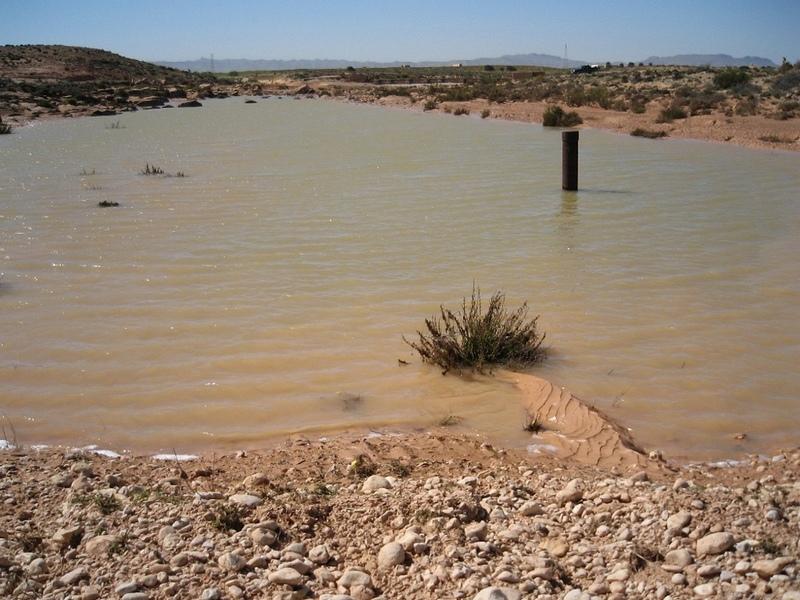
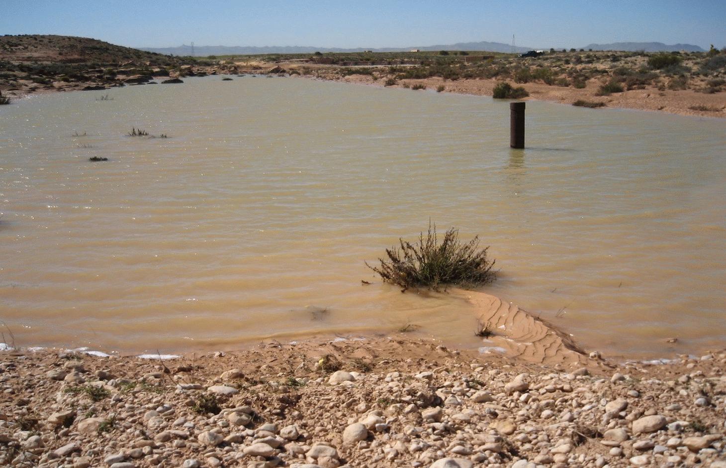
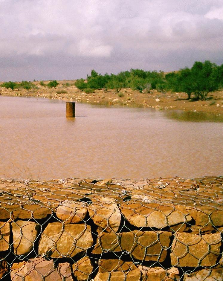
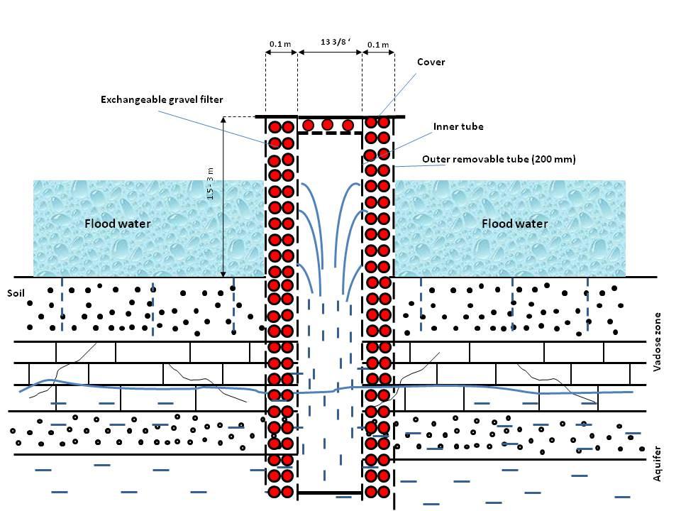
A recharge well comprises a drilled hole, up to 30-40 m deep that reaches the water table, and a surrounding filter used to allow the direct injection of floodwater into the aquifer.
2.2 การอธิบายแบบละเอียดของเทคโนโลยี
คำอธิบาย:
The main worldwide used methods to enhance groundwater replenishment are through recharge basins or recharge wells. Though groundwater recharge aiming at storage of water in the periods of abundance for recovery in times of drought has a long history dating back millennia, the recharge wells began to be used only in the twentieth century, especially during the Second World War following concerns on attacks of the water supply facilities. Its use was extended later to sea intrusion control, treated waste water, water harvesting in the dry areas, and strategic water storage.
Purpose of the Technology: Recharge wells are used in combination with gabion check dams to enhance the infiltration of floodwater into the aquifer. In areas where the permeability of the underlying bedrock in front of a gabion is judged too low, recharge wells could be installed in wadi (ephemeral river) beds. Water is retained by the gabion check dam and it flows through the recharge well allowing accelerated percolation into the aquifer.
Establishment / maintenance activities and inputs: A recharge well consists of a long inner tube surrounded by an outer tube, the circumference of which ranges between 1 and 2 m. The area between the tubes is filled with river bed gravel which acts as a sediment filter. Water enters the well through rectangular-shaped openings (almost 20 cm long and a few mm in width) located in the outer tube, and it flows in the inner hole having passed through the gravel and the rectangular shaped openings of the dill hole. The above-ground height is around 2 to 3 m whereas the depth is linked to the depth of the water table (normally up to 40 m). The drill hole connects directly with the aquifer, where it is connected either directly with the water table or indirectly via cracks. Pond volume is dependent on the size of the gabion check dam but generally ranges between 500 and 3000 m3. The filtered water can directly flow into the aquifer at a rate exceeding what would occur naturally through the soil and the underlying strata.
The design should be conducted primarily by a hydrogeologist and a soil and water conservation specialist in order to determine the potential sites and the required drilling equipment. Drilling needs to be carried out by a specialized company.
Depending on the geological setting, the overall cost is around 5000 to 10000 US$. The recharge wells are used to recharge the deep groundwater aquifers, which are mainly exploited by government agencies. However, private irrigated farms are benefiting indirectly by increased groundwater availability.
Natural / human environment: This technique has been first tried for the replenishment of the Zeuss-Koutine aquifer (south east Tunisia).
2.3 รูปภาพของเทคโนโลยี
อัลบั้มสื่อบันทึก
2.5 ประเทศภูมิภาค หรือสถานที่ตั้งที่เทคโนโลยีได้นำไปใช้และได้รับการครอบคลุมโดยการประเมินนี้
ประเทศ:
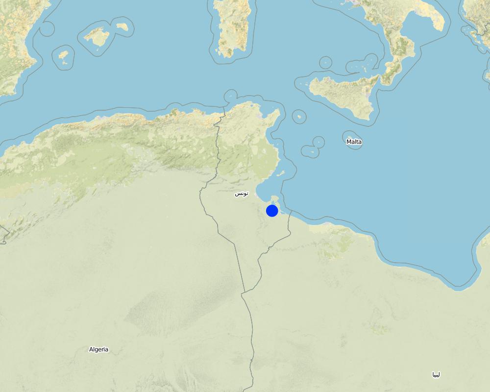
ตูนิเซีย
ภูมิภาค/รัฐ/จังหวัด:
Medenine
ข้อมูลจำเพาะเพิ่มเติมของสถานที่ตั้ง :
Medenine nord
ระบุการกระจายตัวของเทคโนโลยี:
- กระจายไปอย่างสม่ำเสมอในพื้นที่
If precise area is not known, indicate approximate area covered:
- 10-100 ตร.กม.
Map
×2.6 วันที่การดำเนินการ
ถ้าไม่รู้ปีที่แน่นอน ให้ระบุวันที่โดยประมาณ:
- 10-50 ปี
2.7 คำแนะนำของเทคโนโลยี
ให้ระบุว่าเทคโนโลยีถูกแนะนำเข้ามาอย่างไร:
- ทางโครงการหรือจากภายนอก
3. การจัดประเภทของเทคโนโลยี SLM
3.1 วัตถุประสงค์หลักของเทคโนโลยี
- ลด ป้องกัน ฟื้นฟู การเสื่อมโทรมของที่ดิน
- ป้องกันพื้นที่ลุ่มน้ำ/บริเวณท้ายน้ำ โดยร่วมกับเทคโนโลยีอื่นๆ
- สร้างผลกระทบทางด้านเศรษฐกิจที่เป็นประโยชน์
3.2 ประเภทของการใช้ที่ดินในปัจจุบันที่ได้นำเทคโนโลยีไปใช้
Land use mixed within the same land unit:
ใช่
Specify mixed land use (crops/ grazing/ trees):
- Agro-pastoralism (incl. integrated crop-livestock)

พื้นที่ปลูกพืช
- การปลูกไม้ยืนต้น ไม้พุ่ม
จำนวนของฤดูเพาะปลูกต่อปี:
- 1
ระบุ:
Longest growing period in days: 180Longest growing period from month to month: Oct - Apr

ทุ่งหญ้าเลี้ยงสัตว์
Extensive grazing:
- กึ่งโนแมนดิซึ่มหรือแพสโตแรลลิซึ่ม (Semi-nomadism/pastoralism)
แสดงความคิดเห็น:
Major land use problems (compiler’s opinion): Runoff water loss, riverbank erosion, flooding risk, aridity
Major land use problems (land users’ perception): water loss
Constraints of wadi beds
3.3 Has land use changed due to the implementation of the Technology?
Has land use changed due to the implementation of the Technology?
- No (Continue with question 3.4)
3.4 การใช้น้ำ
การใช้น้ำของที่ดินที่มีการใช้เทคโนโลยีอยู่:
- จากน้ำฝน
3.5 กลุ่ม SLM ที่ตรงกับเทคโนโลยีนี้
- การเก็บเกี่ยวน้ำ
- การจัดการน้ำบาดาล
3.6 มาตรการ SLM ที่ประกอบกันเป็นเทคโนโลยี

มาตรการอนุรักษ์ด้วยโครงสร้าง
- S11: อื่น ๆ
แสดงความคิดเห็น:
Main measures: structural measures
3.7 รูปแบบหลักของการเสื่อมโทรมของที่ดินที่ได้รับการแก้ไขโดยเทคโนโลยี

การกัดกร่อนของดินโดยน้ำ
- Wr (Riverbank erosion): การกัดกร่อนริมฝั่งแม่น้ำ
- Wo (Offsite degradation): ผลกระทบนอกพื้นที่

การเสื่อมโทรมของน้ำ
- Ha (Aridification): การเกิดความแห้งแล้ง
- Hq (Decline of groundwater quality): การลดลงของคุณภาพน้ำบาดาล
แสดงความคิดเห็น:
Main type of degradation addressed: Ha: aridification
Secondary types of degradation addressed: Wr: riverbank erosion, Wo: offsite degradation effects, Hq: decline of groundwater quality
Main causes of degradation: over abstraction / excessive withdrawal of water (for irrigation, industry, etc.)
Secondary causes of degradation: disturbance of water cycle (infiltration / runoff), Heavy / extreme rainfall (intensity/amounts)
3.8 การป้องกัน การลดลง หรือการฟื้นฟูความเสื่อมโทรมของที่ดิน
ระบุเป้าหมายของเทคโนโลยีกับความเสื่อมโทรมของที่ดิน:
- ป้องกันความเสื่อมโทรมของที่ดิน
- ลดความเสื่อมโทรมของดิน
แสดงความคิดเห็น:
Main goals: prevention of land degradation
Secondary goals: mitigation / reduction of land degradation
4. ข้อมูลจำเพาะด้านเทคนิค กิจกรรมการนำไปปฏิบัติใช้ ปัจจัยนำเข้า และค่าใช้จ่าย
4.1 แบบแปลนทางเทคนิคของเทคโนโลยี
ผู้เขียน:
Ouessar M., Medenine, Tunisia
4.2 ข้อมูลทั่วไปเกี่ยวกับการคำนวณปัจจัยนำเข้าและค่าใช้จ่าย
อื่นๆ หรือสกุลเงินประจำชาติ (ระบุ):
TND
If relevant, indicate exchange rate from USD to local currency (e.g. 1 USD = 79.9 Brazilian Real): 1 USD =:
1.3
ระบุค่าเฉลี่ยของค่าจ้างในการจ้างแรงงานต่อวัน:
10.00
4.3 กิจกรรมเพื่อการจัดตั้ง
| กิจกรรม | Timing (season) | |
|---|---|---|
| 1. | Drilling | |
| 2. | Installation |
4.4 ค่าใช้จ่ายของปัจจัยนำเข้าที่จำเป็นสำหรับการจัดตั้ง
| ปัจจัยนำเข้า | หน่วย | ปริมาณ | ค่าใช้จ่ายต่อหน่วย | ค่าใช้จ่ายทั้งหมดต่อปัจจัยนำเข้า | %ของค่าใช้จ่ายที่ก่อให้เกิดขึ้นโดยผู้ใช้ที่ดิน | |
|---|---|---|---|---|---|---|
| แรงงาน | Labour | ha | 1.0 | 7000.0 | 7000.0 | |
| วัสดุสำหรับก่อสร้าง | ha | 1.0 | 1000.0 | 1000.0 | ||
| ค่าใช้จ่ายทั้งหมดของการจัดตั้งเทคโนโลยี | 8000.0 | |||||
| Total costs for establishment of the Technology in USD | 6153.85 | |||||
แสดงความคิดเห็น:
Duration of establishment phase: 3 month(s)
4.5 การบำรุงรักษาสภาพหรือกิจกรรมที่เกิดขึ้นเป็นประจำ
| กิจกรรม | ช่วงระยะเวลา/ความถี่ | |
|---|---|---|
| 1. | Desilting of the filter | Ounce in 1-3years (floods) |
| 2. | Repairs |
4.6 ค่าใช้จ่ายของปัจจัยนำเข้าและกิจกรรมที่เกิดขึ้นเป็นประจำที่ต้องการการบำรุงรักษา (ต่อปี)
| ปัจจัยนำเข้า | หน่วย | ปริมาณ | ค่าใช้จ่ายต่อหน่วย | ค่าใช้จ่ายทั้งหมดต่อปัจจัยนำเข้า | %ของค่าใช้จ่ายที่ก่อให้เกิดขึ้นโดยผู้ใช้ที่ดิน | |
|---|---|---|---|---|---|---|
| แรงงาน | Labour | ha | 1.0 | 500.0 | 500.0 | |
| วัสดุสำหรับก่อสร้าง | ha | 1.0 | 100.0 | 100.0 | ||
| ค่าใช้จ่ายทั้งหมดของการบำรุงรักษาสภาพเทคโนโลยี | 600.0 | |||||
| Total costs for maintenance of the Technology in USD | 461.54 | |||||
4.7 ปัจจัยสำคัญที่สุดที่มีผลกระทบต่อค่าใช้จ่าย
ปัจจัยสำคัญที่สุดที่มีผลกระทบต่อค่าใช้จ่ายต่างๆ:
Labour is the most determining factor affecting the costs.
5. สิ่งแวดล้อมทางธรรมชาติและของมนุษย์
5.1 ภูมิอากาศ
ฝนประจำปี
- < 250 ม.ม.
- 251-500 ม.ม.
- 501-750 ม.ม.
- 751-1,000 ม.ม.
- 1,001-1,500 ม.ม.
- 1,501-2,000 ม.ม.
- 2,001-3,000 ม.ม.
- 3,001-4,000 ม.ม.
- > 4,000 ม.ม.
เขตภูมิอากาศเกษตร
- แห้งแล้ง
Thermal climate class: subtropics
5.2 สภาพภูมิประเทศ
ค่าเฉลี่ยความลาดชัน:
- ราบเรียบ (0-2%)
- ลาดที่ไม่ชัน (3-5%)
- ปานกลาง (6-10%)
- เป็นลูกคลื่น (11-15%)
- เป็นเนิน (16-30%)
- ชัน (31-60%)
- ชันมาก (>60%)
ธรณีสัณฐาน:
- ที่ราบสูง/ที่ราบ
- สันเขา
- ไหล่เขา
- ไหล่เนินเขา
- ตีนเนิน
- หุบเขา
ระดับความสูง:
- 0-100 เมตร
- 101-500 เมตร
- 501-1,000 เมตร
- 1,001-1,500 เมตร
- 1,501-2,000 เมตร
- 2,001-2,500 เมตร
- 2,501-3,000 เมตร
- 3,001-4,000 เมตร
- > 4,000 เมตร
ให้ระบุถ้าเทคโนโลยีได้ถูกนำไปใช้:
- ไม่เกี่ยวข้อง
5.3 ดิน
ค่าเฉลี่ยความลึกของดิน:
- ตื้นมาก (0-20 ซ.ม.)
- ตื้น (21-50 ซ.ม.)
- ลึกปานกลาง (51-80 ซ.ม.)
- ลึก (81-120 ซ.ม.)
- ลึกมาก (>120 ซ.ม.)
เนื้อดิน (ดินชั้นบน):
- ปานกลาง (ดินร่วน ทรายแป้ง)
อินทรียวัตถุในดิน:
- ต่ำ (<1%)
(ถ้ามี) ให้แนบคำอธิบายเรื่องดินแบบเต็มหรือระบุข้อมูลที่มีอยู่ เช่น ชนิดของดิน ค่า pH ของดินหรือความเป็นกรดของดิน ความสามารถในการแลกเปลี่ยนประจุบวก ไนโตรเจน ความเค็ม เป็นต้น:
Soil fertility is very low
Soil drainage / infiltration is medium
Soil water storage is medium
5.4 ความเป็นประโยชน์และคุณภาพของน้ำ
ระดับน้ำใต้ดิน:
5-50 เมตร
น้ำไหลบ่าที่ผิวดิน:
ไม่ดีหรือไม่มีเลย
คุณภาพน้ำ (ที่ยังไม่ได้บำบัด):
เป็นน้ำเพื่อการดื่มที่ไม่ดี (จำเป็นต้องได้รับการบำบัด)
ความเค็มของน้ำเป็นปัญหาหรือไม่:
ใช่
กำลังเกิดน้ำท่วมในพื้นที่หรือไม่:
ใช่
บ่อยครั้ง:
เป็นครั้งเป็นคราว
ความคิดเห็นและข้อมูลจำเพาะเพิ่มเติมเรื่องคุณภาพและปริมาณน้ำ:
Seasonal fluctuations: Availability of surface water is poor/none but with periods of excess (e.g. flood)
5.5 ความหลากหลายทางชีวภาพ
ความหลากหลายทางชนิดพันธุ์:
- ปานกลาง
ความหลากหลายของแหล่งที่อยู่:
- ต่ำ
5.6 ลักษณะของผู้ใช้ที่ดินที่นำเทคโนโลยีไปปฏิบัติใช้
อยู่กับที่หรือเร่ร่อน:
- อยู่กับที่
- กึ่งเร่ร่อน
แนวทางการตลาดของระบบการผลิต:
- mixed (subsistence/ commercial)
รายได้ที่มาจากนอกฟาร์ม:
- > 50% ของรายได้ทั้งหมด
ระดับของความมั่งคั่งโดยเปรียบเทียบ:
- พอมีพอกิน
เป็นรายบุคคล/ครัวเรือน:
- ลูกจ้าง (บริษัท รัฐบาล)
ระดับของการใช้เครื่องจักรกล:
- งานที่ใช้แรงกาย
เพศ:
- ชาย
อายุของผู้ใช้ที่ดิน:
- วัยกลางคน
- ผู้สูงอายุ
ระบุลักษณะอื่นๆที่เกี่ยวข้องของผู้ใช้ที่ดิน:
Population density: 10-50 persons/km2
Annual population growth: 0.5% - 1%
70% of the land users are average wealthy and own 75% of the land.
5.7 Average area of land used by land users applying the Technology
- < 0.5 เฮกตาร์
- 0.5-1 เฮกตาร์
- 1-2 เฮกตาร์
- 2-5 เฮกตาร์
- 5-15 เฮกตาร์
- 15-50 เฮกตาร์
- 50-100 เฮกตาร์
- 100-500 เฮกตาร์
- 500-1,000 เฮกตาร์
- 1,000-10,000 เฮกตาร์
- >10,000 เฮกตาร์
พิจารณาว่าเป็นขนาดเล็ก กลาง หรือขนาดใหญ่ (ซึ่งอ้างอิงถึงบริบทระดับท้องถิ่น):
- ขนาดเล็ก
5.8 กรรมสิทธิ์ในที่ดิน สิทธิในการใช้ที่ดินและสิทธิในการใช้น้ำ
กรรมสิทธิ์ในที่ดิน:
- รัฐ
สิทธิในการใช้ที่ดิน:
- เกี่ยวกับชุมชน (ถูกจัดระเบียบ)
สิทธิในการใช้น้ำ:
- เกี่ยวกับชุมชน (ถูกจัดระเบียบ)
แสดงความคิดเห็น:
The recharge wells are used to recharge the deep groundwater aquifers which are mainly exploited by the government agencies. However, private irrigated farms could benefit indirectly, by increased groundwater availability.
5.9 การเข้าถึงบริการและโครงสร้างพื้นฐาน
สุขภาพ:
- จน
- ปานกลาง
- ดี
การศึกษา:
- จน
- ปานกลาง
- ดี
ความช่วยเหลือทางด้านเทคนิค:
- จน
- ปานกลาง
- ดี
การจ้างงาน (เช่น ภายนอกฟาร์ม):
- จน
- ปานกลาง
- ดี
ตลาด:
- จน
- ปานกลาง
- ดี
พลังงาน:
- จน
- ปานกลาง
- ดี
ถนนและการขนส่ง:
- จน
- ปานกลาง
- ดี
น้ำดื่มและการสุขาภิบาล:
- จน
- ปานกลาง
- ดี
บริการด้านการเงิน:
- จน
- ปานกลาง
- ดี
6. ผลกระทบและสรุปคำบอกกล่าว
6.1 ผลกระทบในพื้นที่ดำเนินการ (On-site) จากการใช้เทคโนโลยี
ผลกระทบทางด้านเศรษฐกิจและสังคม
ความเป็นประโยชน์และคุณภาพของน้ำ
การมีน้ำดื่มไว้ให้ใช้
การมีน้ำไว้ให้ปศุสัตว์
การมีน้ำไว้ให้สำหรับการชลประทาน
ผลกระทบด้านสังคมวัฒนธรรมอื่น ๆ
SLM หรือความรู้เรื่องความเสื่อมโทรมของที่ดิน
การบรรเทาความขัดแย้ง
Improved livelihoods and human well-being
แสดงความคิดเห็น/ระบุ:
Increased availability of water for drinking, agriculture and livestock
ผลกระทบด้านนิเวศวิทยา
วัฐจักรน้ำหรือน้ำบ่า
การเก็บเกี่ยวหรือการกักเก็บน้ำ
น้ำบาดาลหรือระดับน้ำในแอ่งน้ำบาดาล
ดิน
ความเค็ม
ผลกระทบด้านนิเวศวิทยาอื่น ๆ
risks of contamination of aquifers
6.2 ผลกระทบนอกพื้นที่ดำเนินการ (Off-site) จากการใช้เทคโนโลยี
น้ำที่ใช้ประโยชน์ได้
น้ำท่วมพื้นที่ท้ายน้ำ
แสดงความคิดเห็น/ระบุ:
In combination with gabion check dams
ความเสียหายต่อโครงสร้างพื้นฐานของรัฐหรือของเอกชน
แสดงความคิดเห็น/ระบุ:
In combination with gabion check dams
Surface water to reach downstream areas
6.3 การเผชิญและความตอบสนองของเทคโนโลยีต่อการเปลี่ยนแปลงสภาพภูมิอากาศที่ค่อยเป็นค่อยไป และสภาพรุนแรงของภูมิอากาศ / ภัยพิบัติ (ที่รับรู้ได้โดยผู้ใช้ที่ดิน)
การเปลี่ยนแปลงสภาพภูมิอากาศที่ค่อยเป็นค่อยไป
การเปลี่ยนแปลงสภาพภูมิอากาศที่ค่อยเป็นค่อยไป
| ฤดู | increase or decrease | เทคโนโลยีมีวิธีการรับมืออย่างไร | |
|---|---|---|---|
| อุณหภูมิประจำปี | เพิ่มขึ้น | ดี |
สภาพรุนแรงของภูมิอากาศ (ภัยพิบัติ)
ภัยพิบัติทางอุตุนิยมวิทยา
| เทคโนโลยีมีวิธีการรับมืออย่างไร | |
|---|---|
| พายุฝนประจำท้องถิ่น | ดี |
| พายุลมประจำท้องถิ่น | ดี |
ภัยพิบัติจากสภาพภูมิอากาศ
| เทคโนโลยีมีวิธีการรับมืออย่างไร | |
|---|---|
| ภัยจากฝนแล้ง | ดี |
ผลลัพธ์ตามมาที่เกี่ยวข้องกับภูมิอากาศอื่น ๆ
ผลลัพธ์ตามมาที่เกี่ยวข้องกับภูมิอากาศอื่น ๆ
| เทคโนโลยีมีวิธีการรับมืออย่างไร | |
|---|---|
| ช่วงการปลูกพืชที่ลดลงมา | ดี |
| extreme floods | ไม่ค่อยดี |
6.4 การวิเคราะห์ค่าใช้จ่ายและผลประโยชน์ที่ได้รับ
ผลประโยชน์ที่ได้รับเปรียบเทียบกับค่าใช้จ่ายในการจัดตั้งเป็นอย่างไร (จากมุมมองของผู้ใช้ที่ดิน)
ผลตอบแทนระยะสั้น:
ด้านบวกอย่างมาก
ผลตอบแทนระยะยาว:
ด้านบวก
ผลประโยชน์ที่ได้รับเปรียบเทียบกับค่าใช้จ่ายในการบำรุงรักษาหรือต้นทุนที่เกิดขึ้นซ้ำอีก เป็นอย่างไร (จากมุมมองของผู้ใช้ที่ดิน)
ผลตอบแทนระยะสั้น:
ด้านบวกอย่างมาก
ผลตอบแทนระยะยาว:
ด้านบวก
แสดงความคิดเห็น:
Long-term benefits are slightly reduced due to silting problems.
6.5 การปรับตัวของเทคโนโลยี
Of all those who have adopted the Technology, how many did so spontaneously, i.e. without receiving any material incentives/ payments?
- 0-10%
แสดงความคิดเห็น:
Comments on acceptance with external material support: It is solely constrcuted by the government agencies.
6.7 จุดแข็ง / ข้อได้เปรียบ / โอกาสของเทคโนโลยี
| จุดแข็ง / ข้อได้เปรียบ / โอกาสในทัศนคติของผู้ใช้ที่ดิน |
|---|
|
Replenishment of the aquifer How can they be sustained / enhanced? Good selection of the site and drilling methods |
| จุดแข็ง / ข้อได้เปรียบ / โอกาสในทัศนคติของผู้รวบรวมหรือวิทยากรหลัก |
|---|
| Enhance groundwater level and quality (reduce salinity) |
6.8 จุดอ่อน / ข้อเสียเปรียบ / ความเสี่ยงของเทคโนโลยีและวิธีการแก้ไข
| จุดอ่อน / ข้อเสียเปรียบ / ความเสี่ยงในทัศนคติของผู้ใช้ที่ดิน | มีวิธีการแก้ไขได้อย่างไร |
|---|---|
| Retain water for dowstreams users | Proper watershed management plan |
| จุดอ่อน / ข้อเสียเปรียบ / ความเสี่ยงในทัศนคติของผู้รวบรวมหรือวิทยากรหลัก | มีวิธีการแก้ไขได้อย่างไร |
|---|---|
| Silting up of the filter | Maintenance of the filters. |
| Malfunction due to aquifer geometry and characteristics | Good selection of the sites |
7. การอ้างอิงและการเชื่อมต่อ
7.1 วิธีการและแหล่งข้อมูล
- การเก็บรวบรวมมาจากรายงานและเอกสารที่มีอยู่
วันที่เก็บรวบรวมข้อมูล(ภาคสนาม) :
10/06/2011
7.2 การอ้างอิงถึงสิ่งตีพิมพ์
หัวข้อ, ผู้เขียน, ปี, หมายเลข ISBN:
Yahyaoui, H., Ouessar, M. 2000. Abstraction and recharge impacts on the ground water in the arid regions of Tunisia: Case of Zeuss-Koutine water table. UNU Desertification Series, 2: 72-78.
ชื่อเรื่อง ผู้เขียน ปี ISBN:
IRA, CRDA-Medenine, UNU
หัวข้อ, ผู้เขียน, ปี, หมายเลข ISBN:
Yahyaoui, H., Chaieb, H., Ouessar, M. 2002. Impact des travaux de conservation des eaux et des sols sur la recharge de la nappe de Zeuss-Koutine (Médenine: Sud-est tunisien). TRMP paper n° 40, Wageningen University, The Netherlands, pp: 71-86.
ชื่อเรื่อง ผู้เขียน ปี ISBN:
IRA, Wegeningen University (NL),
หัวข้อ, ผู้เขียน, ปี, หมายเลข ISBN:
Temmerman, S. 2004. Evaluation of the efficiency of recharge wells on the water supply to the water table in South Tunisia. Graduation dissertation, Ghent University, Belgium.
ชื่อเรื่อง ผู้เขียน ปี ISBN:
IRA, Gent University (BE)
หัวข้อ, ผู้เขียน, ปี, หมายเลข ISBN:
Genin, D., Guillaume, H., Ouessar, M., Ouled Belgacem, A., Romagny, B., Sghaier, M., Taamallah, H. (eds) 2006. Entre la désertification et le développement : la Jeffara tunisienne. CERES, Tunis, 351 pp.
ชื่อเรื่อง ผู้เขียน ปี ISBN:
IRA, IRD
หัวข้อ, ผู้เขียน, ปี, หมายเลข ISBN:
Ouessar M. 2007. Hydrological impacts of rainwater harvesting in wadi Oum Zessar watershed (Southern Tunisia). Ph.D. thesis, Faculty of Bioscience Engineering, Ghent University, Ghent, Belgium, 154 pp.
ชื่อเรื่อง ผู้เขียน ปี ISBN:
IRA, Gent University (BE)
ลิงก์และโมดูล
ขยายทั้งหมด ย่อทั้งหมดลิงก์
Dryland watershed management approach [ตูนิเซีย]
Integrated land and water management approach, including vegetative, management, and agronomic measure
- ผู้รวบรวม: Naceur Mahdi
โมดูล
ไม่มีโมดูล