Controlled grazing in deciduous woods as an alternative to grazing on rangeland [อิตาลี]
- ผู้สร้างสรรค์:
- การอัพเดท:
- ผู้รวบรวม: Lorenzo Borselli
- ผู้เรียบเรียง: –
- ผู้ตรวจสอบ: Deborah Niggli, Alexandra Gavilano
Pascolo controllato
technologies_1463 - อิตาลี
- บทสรุปทั้งหมดในรูปแบบของ PDF
- บทสรุปทั้งหมดในรูปแบบของ PDF เพื่อพิมพ์
- บทสรุปทั้งหมดในรูปหน้าเว็บ
- บทสรุปทั้งหมด (ไม่มีการจัดเรียง)
- Controlled grazing in deciduous woods as an alternative to grazing on rangeland: 20 มีนาคม 2017 (inactive)
- Controlled grazing in deciduous woods as an alternative to grazing on rangeland: 4 เมษายน 2018 (inactive)
- Controlled grazing in deciduous woods as an alternative to grazing on rangeland: 17 เมษายน 2019 (public)
ดูส่วนย่อย
ขยายทั้งหมด ย่อทั้งหมด1. ข้อมูลทั่วไป
1.2 รายละเอียดที่ติดต่อได้ของผู้รวบรวมและองค์กรที่เกี่ยวข้องในการประเมินและการจัดเตรียมทำเอกสารของเทคโนโลยี
ชื่อของโครงการซึ่งอำนวยความสะดวกในการทำเอกสารหรือการประเมินเทคโนโลยี (ถ้าเกี่ยวข้อง)
DESIRE (EU-DES!RE)ชื่อขององค์กรซึ่งอำนวยความสะดวกในการทำเอกสารหรือการประเมินเทคโนโลยี (ถ้าเกี่ยวข้อง)
Universidad Autonoma de San Luis Potosi (Universidad Autonoma de San Luis Potosi) - เม็กซิโกชื่อขององค์กรซึ่งอำนวยความสะดวกในการทำเอกสารหรือการประเมินเทคโนโลยี (ถ้าเกี่ยวข้อง)
Consiglio Nazionale delle Ricerche (CNR) - อิตาลี1.3 เงื่อนไขการใช้ข้อมูลที่ได้บันทึกผ่านทาง WOCAT
ผู้รวบรวมและวิทยากรหลักยอมรับเงื่อนไขเกี่ยวกับการใช้ข้อมูลที่ถูกบันทึกผ่านทาง WOCAT:
ใช่
2. การอธิบายลักษณะของเทคโนโลยี SLM
2.1 การอธิบายแบบสั้น ๆ ของเทคโนโลยี
คำจำกัดความของเทคโนโลยี:
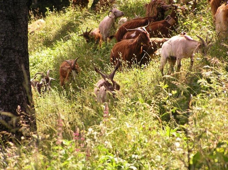
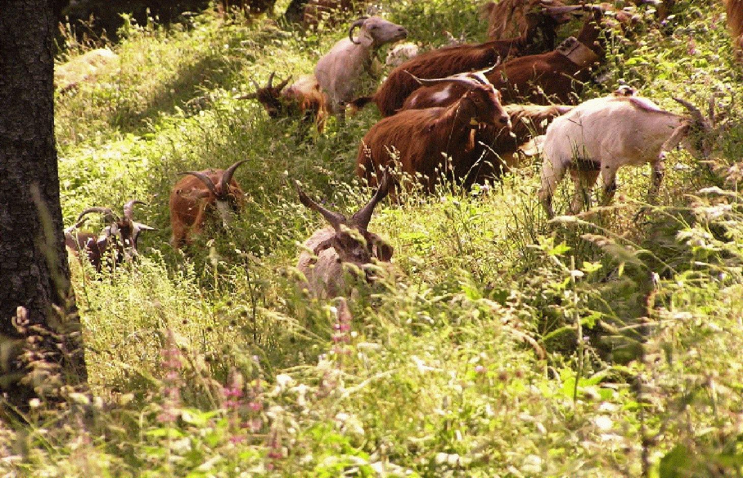
Controlled grazing in deciduous woods seasonally limited in summer when grass cover in rangeland suffers water stress.
2.2 การอธิบายแบบละเอียดของเทคโนโลยี
คำอธิบาย:
During the driest season, farmers shifts grazing to deciduous forest. Grazing in forest is controlled because it is limited to specific areas and with a controlled number of animals (cows and goats). In deciduous forest, the animals can still find green grass in the dry season. This action prevents excessive stress in the surrounding rangelands, which are suffering from a seasonal summer water deficit, as is typical of areas with a Mediterranean climate.
Purpose of the Technology: One purpose of this management technology is to allow grazing in environments that still preserve grasses in the summer dry season. Moreover, this technology can prevent overgrazing (and its consequences in rangeland and pastures). Controlled grazing is typical in the Rendina watershed (Basilicata, Italy).
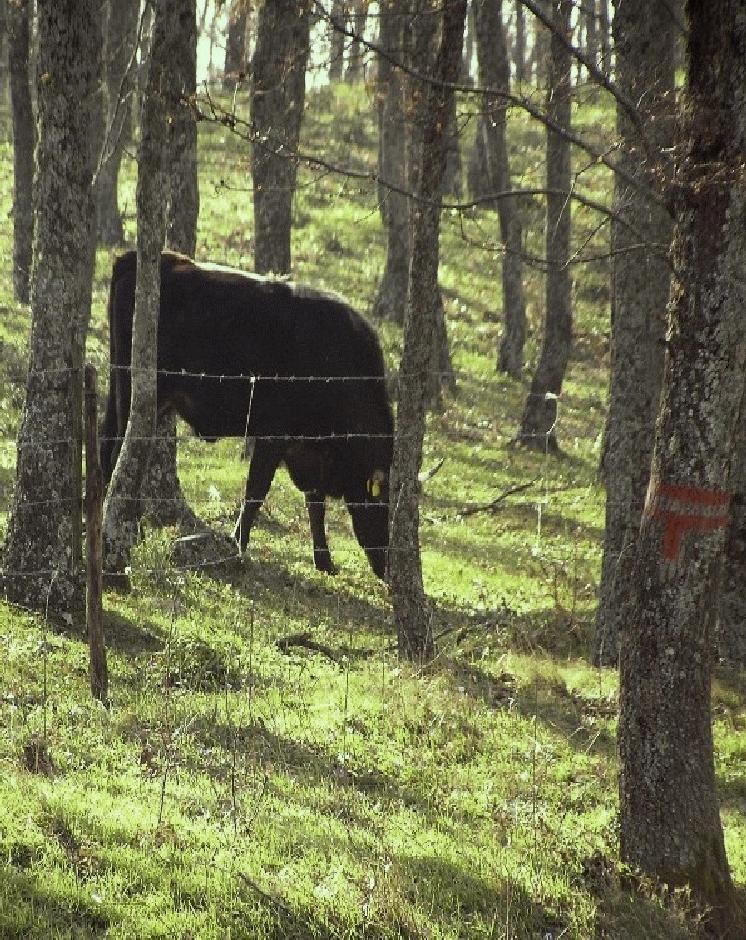
Establishment / maintenance activities and inputs: The upper part of the watershed is located above 800 m a.s.l. and is characterized by deciduous oak forest, which every 20 years is subject to selective cutting. Selective cutting involves cutting a high percentage of a limited range of tree species. Within about 10 years, regeneration of the whole wooded area is possible. This allows for a constant regeneration of the woodland and reduces the probability of a progressive degradation as well as of wildfires due to an excessive build-up of the fuel load. The surrounding areas are either cultivated or rangeland and suffer from the soil erosion and landslides that give rise to degradation and hence to the loss of arable lands.
Natural / human environment: Forests are either government-owned or privately-owned, but controlled grazing woodland areas are mostly government-owned. Based on the number of grazing animals admitted, the farmers need to pay a tax to the municipalities or regions. Each farmer has a specific number of animals admitted to the woodland area and there is a overall maximum of animals especially during summer, when a risk of overgrazing exists. Access to private forest, on the other hand, is arranged directly with the owners.
Grazing is organized on a daily basis by the herdsman. The controlled grazing areas are always located in the woodlands where selective cutting is carried out. In such areas livestock during summer can enter and move more easily in the relatively cool conditions.
When controlled grazing is adopted as the conventional management technology, selective cutting of trees every 20 years is also used to provide additional earnings from the sale of firewood.
Annual rainfall is 500 mm with two rainy seasons (October-November and March-May). Potential evapotranspiration is up to 1100 mm annually. The Rendina catchment ranges from humid-subhumid to subhumid-semiarid conditions. The surrounding area ranges from (subhumid)-semiarid to semiarid-arid.
2.3 รูปภาพของเทคโนโลยี
อัลบั้มสื่อบันทึก
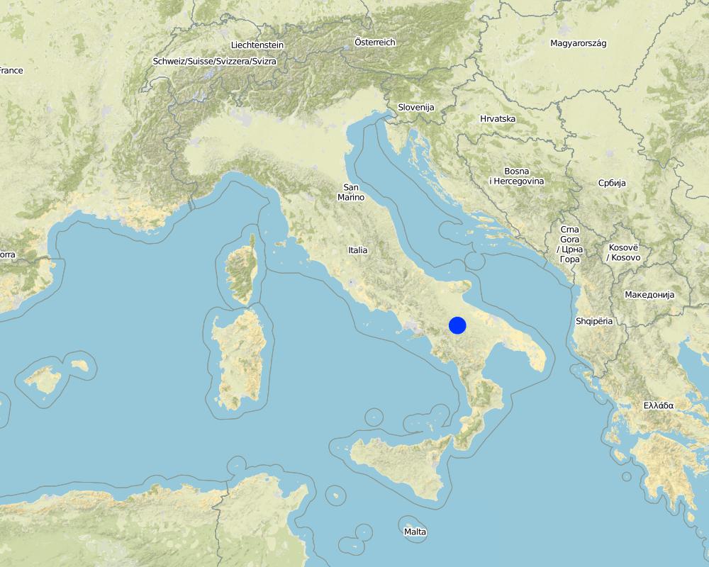
2.5 ประเทศภูมิภาค หรือสถานที่ตั้งที่เทคโนโลยีได้นำไปใช้และได้รับการครอบคลุมโดยการประเมินนี้
ประเทศ:
อิตาลี
ภูมิภาค/รัฐ/จังหวัด:
Potenza / regione basilicata
ข้อมูลจำเพาะเพิ่มเติมของสถานที่ตั้ง :
Rendina Basin
แสดงความคิดเห็น:
Total area covered by the SLM Technology is 10 km2.
Renina Watershed - above 800 m a.s.l.
Map
×2.6 วันที่การดำเนินการ
ถ้าไม่รู้ปีที่แน่นอน ให้ระบุวันที่โดยประมาณ:
- 10-50 ปี
2.7 คำแนะนำของเทคโนโลยี
ให้ระบุว่าเทคโนโลยีถูกแนะนำเข้ามาอย่างไร:
- ด้วยการริเริ่มของผู้ใช้ที่ดินเอง
3. การจัดประเภทของเทคโนโลยี SLM
3.1 วัตถุประสงค์หลักของเทคโนโลยี
- ลด ป้องกัน ฟื้นฟู การเสื่อมโทรมของที่ดิน
- อนุรักษ์ระบบนิเวศน์
3.2 ประเภทของการใช้ที่ดินในปัจจุบันที่ได้นำเทคโนโลยีไปใช้
Land use mixed within the same land unit:
ใช่
Specify mixed land use (crops/ grazing/ trees):
- ปศุสัตว์ร่วมกับการทำป่าไม้ (Silvo-pastoralism)

ทุ่งหญ้าเลี้ยงสัตว์
Animal type:
- goats
- cows

ป่า/พื้นที่ทำไม้
- ป่ากึ่งธรรมชาติ / พื้นที่ทำไม้
(Semi-)natural forests/ woodlands: Specify management type:
- การตัดไม้ที่มีคัดเลือก (Selective felling)
ผลิตภัณฑ์และบริการ:
- การแทะเล็มหญ้า / การเก็บกินหญ้า
แสดงความคิดเห็น:
Major land use problems (compiler’s opinion): The land users claim about reduction of vegetation cover.
Major land use problems (land users’ perception): This impacts water and tillage erosion and landslides but is not considered as main issue by land user, yet.
Future (final) land use (after implementation of SLM Technology): Mixed: Ms: Silvo-pastoralism
Number of growing seasons per year: 2
Longest growing period in days: 90 Longest growing period from month to month: Apr - Jun Second longest growing period in days: 30 Second longest growing period from month to month: Oct - Oct
Livestock density: 25-50 LU /km2
3.3 Has land use changed due to the implementation of the Technology?
Has land use changed due to the implementation of the Technology?
- Yes (Please fill out the questions below with regard to the land use before implementation of the Technology)
Land use mixed within the same land unit:
ไม่ใช่
ป่า/พื้นที่ทำไม้
- ป่ากึ่งธรรมชาติ / พื้นที่ทำไม้
3.4 การใช้น้ำ
การใช้น้ำของที่ดินที่มีการใช้เทคโนโลยีอยู่:
- จากน้ำฝน
3.5 กลุ่ม SLM ที่ตรงกับเทคโนโลยีนี้
- การจัดการปศุสัตว์และทุ่งหญ้าเลี้ยงสัตว์
3.6 มาตรการ SLM ที่ประกอบกันเป็นเทคโนโลยี

มาตรการอนุรักษ์ด้วยการจัดการ
- M7: อื่นๆ
แสดงความคิดเห็น:
Main measures: management measures
3.7 รูปแบบหลักของการเสื่อมโทรมของที่ดินที่ได้รับการแก้ไขโดยเทคโนโลยี

การกัดกร่อนของดินโดยน้ำ
- Wt (Loss of topsoil): การสูญเสียดินชั้นบนหรือการกัดกร่อนที่ผิวดิน

การเสื่อมโทรมของดินทางด้านชีวภาพ
- Bc (Reduction of vegetation cover): การลดลงของจำนวนพืชที่ปกคลุมดิน
- Bq (Quantity/biomass decline): การลดลงของปริมาณหรือมวลชีวภาพ
แสดงความคิดเห็น:
Main type of degradation addressed: Bc: reduction of vegetation cover
Secondary types of degradation addressed: Wt: loss of topsoil / surface erosion, Bq: quantity / biomass decline
Main causes of degradation: overgrazing, land tenure
Secondary causes of degradation: droughts
3.8 การป้องกัน การลดลง หรือการฟื้นฟูความเสื่อมโทรมของที่ดิน
ระบุเป้าหมายของเทคโนโลยีกับความเสื่อมโทรมของที่ดิน:
- ลดความเสื่อมโทรมของดิน
4. ข้อมูลจำเพาะด้านเทคนิค กิจกรรมการนำไปปฏิบัติใช้ ปัจจัยนำเข้า และค่าใช้จ่าย
4.1 แบบแปลนทางเทคนิคของเทคโนโลยี
ข้อมูลจำเพาะด้านเทคนิค (แบบแปลนทางเทคนิคของเทคโนโลยี):
Technical knowledge required for field staff / advisors: moderate
Technical knowledge required for land users: moderate
Main technical functions: improvement of ground cover
Secondary technical functions: stabilisation of soil (eg by tree roots against land slides), increase of biomass (quantity)
Change of land use practices / intensity level
4.2 ข้อมูลทั่วไปเกี่ยวกับการคำนวณปัจจัยนำเข้าและค่าใช้จ่าย
อื่นๆ หรือสกุลเงินประจำชาติ (ระบุ):
euro
If relevant, indicate exchange rate from USD to local currency (e.g. 1 USD = 79.9 Brazilian Real): 1 USD =:
0.8
ระบุค่าเฉลี่ยของค่าจ้างในการจ้างแรงงานต่อวัน:
100.00
4.3 กิจกรรมเพื่อการจัดตั้ง
| กิจกรรม | Timing (season) | |
|---|---|---|
| 1. | Selective cutting of woodland |
4.4 ค่าใช้จ่ายของปัจจัยนำเข้าที่จำเป็นสำหรับการจัดตั้ง
| ปัจจัยนำเข้า | หน่วย | ปริมาณ | ค่าใช้จ่ายต่อหน่วย | ค่าใช้จ่ายทั้งหมดต่อปัจจัยนำเข้า | %ของค่าใช้จ่ายที่ก่อให้เกิดขึ้นโดยผู้ใช้ที่ดิน | |
|---|---|---|---|---|---|---|
| แรงงาน | Selective cutting of woodland | ha | 2.0 | 300.0 | 600.0 | 50.0 |
| แรงงาน | Labour | ha | 1.0 | 100.0 | 100.0 | 100.0 |
| ค่าใช้จ่ายทั้งหมดของการจัดตั้งเทคโนโลยี | 700.0 | |||||
| Total costs for establishment of the Technology in USD | 875.0 | |||||
แสดงความคิดเห็น:
Duration of establishment phase: 1 month(s)
4.5 การบำรุงรักษาสภาพหรือกิจกรรมที่เกิดขึ้นเป็นประจำ
| กิจกรรม | ช่วงระยะเวลา/ความถี่ | |
|---|---|---|
| 1. | Selective cutting of woodland every 20 years | |
| 2. | Shifting animals in closed woodland areas |
4.6 ค่าใช้จ่ายของปัจจัยนำเข้าและกิจกรรมที่เกิดขึ้นเป็นประจำที่ต้องการการบำรุงรักษา (ต่อปี)
| ปัจจัยนำเข้า | หน่วย | ปริมาณ | ค่าใช้จ่ายต่อหน่วย | ค่าใช้จ่ายทั้งหมดต่อปัจจัยนำเข้า | %ของค่าใช้จ่ายที่ก่อให้เกิดขึ้นโดยผู้ใช้ที่ดิน | |
|---|---|---|---|---|---|---|
| แรงงาน | Selective cutting of woodland every 20 years | ha | 2.0 | 300.0 | 600.0 | 50.0 |
| แรงงาน | Shifting animals in closed woodland areas | ha | 2.0 | 150.0 | 300.0 | 100.0 |
| แรงงาน | Labour | ha | 1.0 | 75.0 | 75.0 | 100.0 |
| ค่าใช้จ่ายทั้งหมดของการบำรุงรักษาสภาพเทคโนโลยี | 975.0 | |||||
| Total costs for maintenance of the Technology in USD | 1218.75 | |||||
แสดงความคิดเห็น:
Selective felling only done every 20 years. Hence the costs ae not as high as they might seem.
4.7 ปัจจัยสำคัญที่สุดที่มีผลกระทบต่อค่าใช้จ่าย
ปัจจัยสำคัญที่สุดที่มีผลกระทบต่อค่าใช้จ่ายต่างๆ:
Labour costs are the most important determining factor affecting the costs.
5. สิ่งแวดล้อมทางธรรมชาติและของมนุษย์
5.1 ภูมิอากาศ
ฝนประจำปี
- < 250 ม.ม.
- 251-500 ม.ม.
- 501-750 ม.ม.
- 751-1,000 ม.ม.
- 1,001-1,500 ม.ม.
- 1,501-2,000 ม.ม.
- 2,001-3,000 ม.ม.
- 3,001-4,000 ม.ม.
- > 4,000 ม.ม.
ข้อมูลจำเพาะ/ความคิดเห็นเรื่องปริมาณน้ำฝน:
autumn and spring rain season
เขตภูมิอากาศเกษตร
- กึ่งชุ่มชื้น
Thermal climate class: temperate
5.2 สภาพภูมิประเทศ
ค่าเฉลี่ยความลาดชัน:
- ราบเรียบ (0-2%)
- ลาดที่ไม่ชัน (3-5%)
- ปานกลาง (6-10%)
- เป็นลูกคลื่น (11-15%)
- เป็นเนิน (16-30%)
- ชัน (31-60%)
- ชันมาก (>60%)
ธรณีสัณฐาน:
- ที่ราบสูง/ที่ราบ
- สันเขา
- ไหล่เขา
- ไหล่เนินเขา
- ตีนเนิน
- หุบเขา
ระดับความสูง:
- 0-100 เมตร
- 101-500 เมตร
- 501-1,000 เมตร
- 1,001-1,500 เมตร
- 1,501-2,000 เมตร
- 2,001-2,500 เมตร
- 2,501-3,000 เมตร
- 3,001-4,000 เมตร
- > 4,000 เมตร
5.3 ดิน
ค่าเฉลี่ยความลึกของดิน:
- ตื้นมาก (0-20 ซ.ม.)
- ตื้น (21-50 ซ.ม.)
- ลึกปานกลาง (51-80 ซ.ม.)
- ลึก (81-120 ซ.ม.)
- ลึกมาก (>120 ซ.ม.)
เนื้อดิน (ดินชั้นบน):
- ปานกลาง (ดินร่วน ทรายแป้ง)
- ละเอียด/หนัก (ดินเหนียว)
อินทรียวัตถุในดิน:
- สูง (>3%)
(ถ้ามี) ให้แนบคำอธิบายเรื่องดินแบบเต็มหรือระบุข้อมูลที่มีอยู่ เช่น ชนิดของดิน ค่า pH ของดินหรือความเป็นกรดของดิน ความสามารถในการแลกเปลี่ยนประจุบวก ไนโตรเจน ความเค็ม เป็นต้น:
Soil fertility is: Medium-high
Soil drainage/infiltration is good
Soil water storage capacity is high
5.4 ความเป็นประโยชน์และคุณภาพของน้ำ
ระดับน้ำใต้ดิน:
5-50 เมตร
น้ำไหลบ่าที่ผิวดิน:
ปานกลาง
คุณภาพน้ำ (ที่ยังไม่ได้บำบัด):
เป็นน้ำเพื่อการดื่มที่ดี
5.5 ความหลากหลายทางชีวภาพ
ความหลากหลายทางชนิดพันธุ์:
- ปานกลาง
5.6 ลักษณะของผู้ใช้ที่ดินที่นำเทคโนโลยีไปปฏิบัติใช้
แนวทางการตลาดของระบบการผลิต:
- mixed (subsistence/ commercial)
- ทำการค้า/การตลาด
รายได้ที่มาจากนอกฟาร์ม:
- < 10% ของรายได้ทั้งหมด
ระดับของความมั่งคั่งโดยเปรียบเทียบ:
- จน
- พอมีพอกิน
เป็นรายบุคคล/ครัวเรือน:
- เป็นรายบุคคล/ครัวเรือน
เพศ:
- ชาย
ระบุลักษณะอื่นๆที่เกี่ยวข้องของผู้ใช้ที่ดิน:
Land users applying the Technology are mainly common / average land users
Population density: 10-50 persons/km2
Annual population growth: < 0.5%
10% of the land users are rich.
60% of the land users are average wealthy and own 80% of the land.
30% of the land users are poor.
5.7 Average area of land used by land users applying the Technology
- < 0.5 เฮกตาร์
- 0.5-1 เฮกตาร์
- 1-2 เฮกตาร์
- 2-5 เฮกตาร์
- 5-15 เฮกตาร์
- 15-50 เฮกตาร์
- 50-100 เฮกตาร์
- 100-500 เฮกตาร์
- 500-1,000 เฮกตาร์
- 1,000-10,000 เฮกตาร์
- >10,000 เฮกตาร์
พิจารณาว่าเป็นขนาดเล็ก กลาง หรือขนาดใหญ่ (ซึ่งอ้างอิงถึงบริบทระดับท้องถิ่น):
- ขนาดกลาง
แสดงความคิดเห็น:
Average area of land owned or leased by land users applying the Technology: Also 5-15 ha, 15-50 ha
5.8 กรรมสิทธิ์ในที่ดิน สิทธิในการใช้ที่ดินและสิทธิในการใช้น้ำ
กรรมสิทธิ์ในที่ดิน:
- รายบุคคล ไม่ได้รับสิทธิครอบครอง
สิทธิในการใช้ที่ดิน:
- เช่า
- รายบุคคล
สิทธิในการใช้น้ำ:
- เข้าถึงได้แบบเปิด (ไม่ได้จัดระเบียบ)
- รายบุคคล
5.9 การเข้าถึงบริการและโครงสร้างพื้นฐาน
สุขภาพ:
- จน
- ปานกลาง
- ดี
การศึกษา:
- จน
- ปานกลาง
- ดี
ความช่วยเหลือทางด้านเทคนิค:
- จน
- ปานกลาง
- ดี
การจ้างงาน (เช่น ภายนอกฟาร์ม):
- จน
- ปานกลาง
- ดี
ตลาด:
- จน
- ปานกลาง
- ดี
พลังงาน:
- จน
- ปานกลาง
- ดี
ถนนและการขนส่ง:
- จน
- ปานกลาง
- ดี
น้ำดื่มและการสุขาภิบาล:
- จน
- ปานกลาง
- ดี
บริการด้านการเงิน:
- จน
- ปานกลาง
- ดี
6. ผลกระทบและสรุปคำบอกกล่าว
6.1 ผลกระทบในพื้นที่ดำเนินการ (On-site) จากการใช้เทคโนโลยี
ผลกระทบทางด้านเศรษฐกิจและสังคม
การผลิต
การผลิตพืชผล
การผลิตสัตว์
การเสี่ยงต่อความล้มเหลวในการผลิต
การผลิตพลังงาน
แสดงความคิดเห็น/ระบุ:
Forest wood
ผลกระทบด้านสังคมวัฒนธรรมอื่น ๆ
SLM หรือความรู้เรื่องความเสื่อมโทรมของที่ดิน
Improved livelihoods and human well-being
แสดงความคิดเห็น/ระบุ:
The technology can contribute to education of young farmers.
ผลกระทบด้านนิเวศวิทยา
ดิน
สิ่งปกคลุมดิน
การสูญเสียดิน
ความหลากหลายทางชีวภาพของพืชและสัตว์
มวลชีวภาพ/เหนือดินชั้น C
ผลกระทบด้านนิเวศวิทยาอื่น ๆ
Risk of overgrazing in the woodland
แสดงความคิดเห็น/ระบุ:
Only if grazing is not well controlled
6.2 ผลกระทบนอกพื้นที่ดำเนินการ (Off-site) จากการใช้เทคโนโลยี
น้ำท่วมพื้นที่ท้ายน้ำ
การทับถมของดินตะกอนพื้นที่ท้ายน้ำ
ความเสียหายต่อโครงสร้างพื้นฐานของรัฐหรือของเอกชน
6.3 การเผชิญและความตอบสนองของเทคโนโลยีต่อการเปลี่ยนแปลงสภาพภูมิอากาศที่ค่อยเป็นค่อยไป และสภาพรุนแรงของภูมิอากาศ / ภัยพิบัติ (ที่รับรู้ได้โดยผู้ใช้ที่ดิน)
การเปลี่ยนแปลงสภาพภูมิอากาศที่ค่อยเป็นค่อยไป
การเปลี่ยนแปลงสภาพภูมิอากาศที่ค่อยเป็นค่อยไป
| ฤดู | increase or decrease | เทคโนโลยีมีวิธีการรับมืออย่างไร | |
|---|---|---|---|
| อุณหภูมิประจำปี | เพิ่มขึ้น | ดี |
ผลลัพธ์ตามมาที่เกี่ยวข้องกับภูมิอากาศอื่น ๆ
ผลลัพธ์ตามมาที่เกี่ยวข้องกับภูมิอากาศอื่น ๆ
| เทคโนโลยีมีวิธีการรับมืออย่างไร | |
|---|---|
| ช่วงการปลูกพืชที่ลดลงมา | ไม่ค่อยดี |
แสดงความคิดเห็น:
increase the number or the extension of the areas within the basin where controlled grazing can be established and performed.
6.4 การวิเคราะห์ค่าใช้จ่ายและผลประโยชน์ที่ได้รับ
ผลประโยชน์ที่ได้รับเปรียบเทียบกับค่าใช้จ่ายในการจัดตั้งเป็นอย่างไร (จากมุมมองของผู้ใช้ที่ดิน)
ผลตอบแทนระยะสั้น:
ด้านบวกเล็กน้อย
ผลตอบแทนระยะยาว:
ด้านบวก
ผลประโยชน์ที่ได้รับเปรียบเทียบกับค่าใช้จ่ายในการบำรุงรักษาหรือต้นทุนที่เกิดขึ้นซ้ำอีก เป็นอย่างไร (จากมุมมองของผู้ใช้ที่ดิน)
ผลตอบแทนระยะสั้น:
ด้านบวก
ผลตอบแทนระยะยาว:
ด้านบวก
แสดงความคิดเห็น:
It is very cheap to maintain the measure. In the surrounding areas, where land should be less degraded due to reduced grazing, more trees can be planted and allowed to grow in future.
6.5 การปรับตัวของเทคโนโลยี
ถ้ามีข้อมูลให้บอกปริมาณด้วย (จำนวนของครัวเรือนหรือครอบคลุมพื้นที่):
20
Of all those who have adopted the Technology, how many did so spontaneously, i.e. without receiving any material incentives/ payments?
- 51-90%
แสดงความคิดเห็น:
50% of land user families have adopted the Technology with external material support
10 land user families have adopted the Technology with external material support
50% of land user families have adopted the Technology without any external material support
10 land user families have adopted the Technology without any external material support
There is no trend towards spontaneous adoption of the Technology
6.7 จุดแข็ง / ข้อได้เปรียบ / โอกาสของเทคโนโลยี
| จุดแข็ง / ข้อได้เปรียบ / โอกาสในทัศนคติของผู้ใช้ที่ดิน |
|---|
|
good animal production How can they be sustained / enhanced? the general quality of the products of the grazing (milk, beef and cheese) is improved due to the availability of more grass and water in the driest periods of the year. |
| จุดแข็ง / ข้อได้เปรียบ / โอกาสในทัศนคติของผู้รวบรวมหรือวิทยากรหลัก |
|---|
|
good impact with low cost How can they be sustained / enhanced? facilitate access to public forest land |
6.8 จุดอ่อน / ข้อเสียเปรียบ / ความเสี่ยงของเทคโนโลยีและวิธีการแก้ไข
| จุดอ่อน / ข้อเสียเปรียบ / ความเสี่ยงในทัศนคติของผู้ใช้ที่ดิน | มีวิธีการแก้ไขได้อย่างไร |
|---|---|
| risk of overgrazing of the woodland area, if the area is not well controlled | ensure control mechanisms |
| rights of access to public lands and forest management rules | the regional legislative process should define better the management of the access of farmers to public lands and in general the whole controlled grazing process. |
| จุดอ่อน / ข้อเสียเปรียบ / ความเสี่ยงในทัศนคติของผู้รวบรวมหรือวิทยากรหลัก | มีวิธีการแก้ไขได้อย่างไร |
|---|---|
| limited wooded areas available for public access | creation of managed enlosures in order to increase natural reforestation or afforestation. |
7. การอ้างอิงและการเชื่อมต่อ
7.1 วิธีการและแหล่งข้อมูล
7.2 การอ้างอิงถึงสิ่งตีพิมพ์
หัวข้อ, ผู้เขียน, ปี, หมายเลข ISBN:
Official Bulletin of the Basilicata region (Italy): N. 29 – 29/04/2002; N. 22 – 16/06/2008.Cocca C. & Campanile G. (2005). Pascolo in bosco solo se controllato. Agrifoglio, N. 7, pages 20-21.
ลิงก์และโมดูล
ขยายทั้งหมด ย่อทั้งหมดลิงก์
ไม่มีลิงก์
โมดูล
ไม่มีโมดูล