Improved terraces [เนปาล]
- ผู้สร้างสรรค์:
- การอัพเดท:
- ผู้รวบรวม: Madhav Dhakal
- ผู้เรียบเรียง: –
- ผู้ตรวจสอบ: David Streiff, Alexandra Gavilano
GARA SUDHAR- Nepali
technologies_1499 - เนปาล
ดูส่วนย่อย
ขยายทั้งหมด ย่อทั้งหมด1. ข้อมูลทั่วไป
1.2 รายละเอียดที่ติดต่อได้ของผู้รวบรวมและองค์กรที่เกี่ยวข้องในการประเมินและการจัดเตรียมทำเอกสารของเทคโนโลยี
ผู้เชี่ยวชาญ SLM:
ผู้เชี่ยวชาญ SLM:
Shreshta Bhubhan
PARDYP/ICIMOD
เนปาล
ผู้เชี่ยวชาญ SLM:
Nakarmi Gopal
PARDYP/ICIMOD
เนปาล
ผู้เชี่ยวชาญ SLM:
Merz Juerg
PARDYP/ICIMOD
สวิตเซอร์แลนด์
ผู้เชี่ยวชาญ SLM:
Shrestha Smriti
PARDYP/ICIMOD
เนปาล
ผู้เชี่ยวชาญ SLM:
Adhikari Krishna.Raj
PARDYP/ICIMOD
เนปาล
ผู้เชี่ยวชาญ SLM:
Shah P.B.
PARDYP/ICIMOD
เนปาล
ผู้เชี่ยวชาญ SLM:
Bhuchar Sanjeev
PARDYP/ICIMOD
เนปาล
ผู้เชี่ยวชาญ SLM:
Singh Bijendra K
District Soil Conservation Office Dhulikhel
เนปาล
ผู้ใช้ที่ดิน:
Thapa Kalpana
เนปาล
ผู้ใช้ที่ดิน:
Thapa Gore
เนปาล
ผู้ใช้ที่ดิน:
Thapa Leela
เนปาล
ผู้ใช้ที่ดิน:
Tamang Indra
เนปาล
ผู้เชี่ยวชาญ SLM:
ชื่อของโครงการซึ่งอำนวยความสะดวกในการทำเอกสารหรือการประเมินเทคโนโลยี (ถ้าเกี่ยวข้อง)
People and Resource Dynamics Project, Nepal (PARDYP)ชื่อขององค์กรซึ่งอำนวยความสะดวกในการทำเอกสารหรือการประเมินเทคโนโลยี (ถ้าเกี่ยวข้อง)
ICIMOD International Centre for Integrated Mountain Development (ICIMOD) - เนปาลชื่อขององค์กรซึ่งอำนวยความสะดวกในการทำเอกสารหรือการประเมินเทคโนโลยี (ถ้าเกี่ยวข้อง)
District Soil Conservation Office (DSCO) - เนปาล1.3 เงื่อนไขการใช้ข้อมูลที่ได้บันทึกผ่านทาง WOCAT
ผู้รวบรวมและวิทยากรหลักยอมรับเงื่อนไขเกี่ยวกับการใช้ข้อมูลที่ถูกบันทึกผ่านทาง WOCAT:
ใช่
2. การอธิบายลักษณะของเทคโนโลยี SLM
2.1 การอธิบายแบบสั้น ๆ ของเทคโนโลยี
คำจำกัดความของเทคโนโลยี:
Hillside forward-sloping terracing and stabilisation using structural and vegetative measures
2.2 การอธิบายแบบละเอียดของเทคโนโลยี
คำอธิบาย:
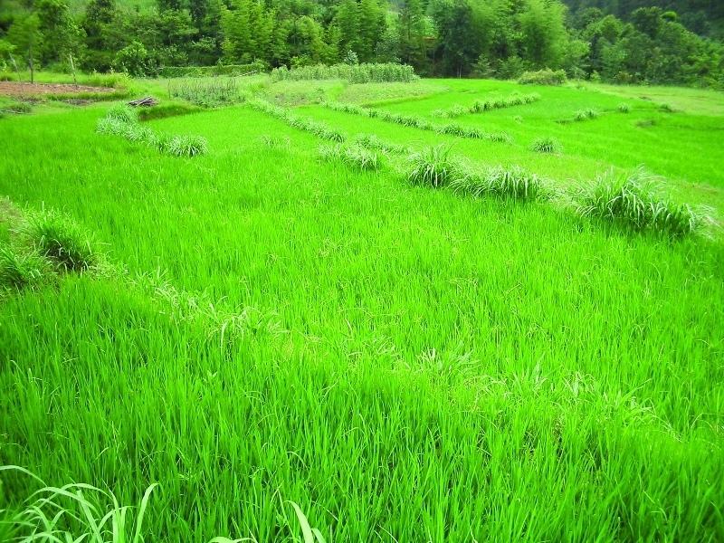
This technology addresses the soil erosion and water runoff problems associated with traditional outward-sloping terraces by reshaping the land into a series of level or gently sloping platforms across the slope. This technology is a variant of sloping land agricultural technology (SALT) or contour hedgerow technology. Nitrogen-fixing hedgerow species and quality fodder grass species, which bind the soil, are cultivated along terrace riser margins to improve terrace stability. This also enhances soil fertility and increases fodder availability. The plants are grown in either single or multiple layers. The practice is applied under rainfed conditions and is culturally acceptable and affordable. After establishment, the technology also addresses the problems of fodder scarcity making it easier and less time consuming for women and girls to gather fodder.
The hedgerow and grass species are established between January and June. Complete establishment of this technology may take one year. The first step in creating the terraces is to build retaining walls using cement bags filled with soil which are then supported with bamboo cuttings along the contour (= future terrace risers). This divides the land into the planned terrace sections. The length and width of the terraces depends on the size and shape of the original field. Secondly, the soil is excavated from the upper part of the terraces and is used to build up the lower part above and behind the terrace riser wall to create a level bed. The fertile top soil must be kept aside and later spread over the newly terraced fields. The final step is to plant grass and hedgerow species on the outermost margins of the terrace above the risers.
Maintenance involves slicing the terrace risers once or twice a year with a spade, and smoothing off rills that appear on the surface of terraces after the premonsoon and monsoon periods. Hedgerows should be cut regularly but not more than twice a year, normally to a height of about 50 cm. Grasses should be cut about once to twice a month depending on their rate of growth.
The technology is applied under humid subtropical climate conditions (1300 mm annual rainfall with about 80% of it falling in the monsoon months of June - September). The case study area has hill slopes of 16-30% that are mostly highly erodible red soils (FAO classification: luvisols).
2.3 รูปภาพของเทคโนโลยี
อัลบั้มสื่อบันทึก
2.5 ประเทศภูมิภาค หรือสถานที่ตั้งที่เทคโนโลยีได้นำไปใช้และได้รับการครอบคลุมโดยการประเมินนี้
ประเทศ:
เนปาล
ข้อมูลจำเพาะเพิ่มเติมของสถานที่ตั้ง :
Hokse VDC ward no2
ระบุการกระจายตัวของเทคโนโลยี:
- กระจายไปอย่างสม่ำเสมอในพื้นที่
If the Technology is evenly spread over an area, specify area covered (in km2):
0.0126
If precise area is not known, indicate approximate area covered:
- < 0.1 ตร.กม.(10 เฮกตาร์)
แสดงความคิดเห็น:
Total area covered by the SLM Technology is 0.0126 km2.
The technology has been evaluated on the bases of village as a unit. Therefore the values calculated in terms of land use percentages is on the bases of village( Kubinde) data.
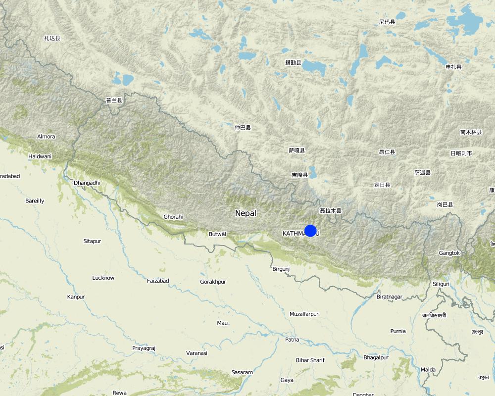
Map
×2.6 วันที่การดำเนินการ
ถ้าไม่รู้ปีที่แน่นอน ให้ระบุวันที่โดยประมาณ:
- มากกว่า 50 ปี (แบบดั้งเดิม)
2.7 คำแนะนำของเทคโนโลยี
ให้ระบุว่าเทคโนโลยีถูกแนะนำเข้ามาอย่างไร:
- ทางโครงการหรือจากภายนอก
ความคิดเห็น (ประเภทของโครงการ เป็นต้น) :
It is a combination of traditional knowledge and practice along with new scientific research findings from within the region and elsewhere, e.g., N-fixing fodder species related information from Phillipines.
3. การจัดประเภทของเทคโนโลยี SLM
3.1 วัตถุประสงค์หลักของเทคโนโลยี
- ลด ป้องกัน ฟื้นฟู การเสื่อมโทรมของที่ดิน
3.2 ประเภทของการใช้ที่ดินในปัจจุบันที่ได้นำเทคโนโลยีไปใช้

พื้นที่ปลูกพืช
- การปลูกพืชล้มลุกอายุปีเดียว
Annual cropping - Specify crops:
- cereals - maize
- legumes and pulses - beans
- root/tuber crops - potatoes
- wheat, chili, tomatoes
จำนวนของฤดูเพาะปลูกต่อปี:
- 3
ระบุ:
Longest growing period in days: 150; Longest growing period from month to month: Jun - Oct; Second longest growing period in days: 120; Second longest growing period from month to month: Nov - Feb
แสดงความคิดเห็น:
Major cash crop: Potato and tomato
Major food crop: Maize and wheat
Other: Beans and chilli
Major land use problems (compiler’s opinion): The major land use problem in the area documented is the small per capita cropping landholding size. The fields are mostly rainfed and have low soil fertility and acidity problems and are susceptible to erosion. The high intensity of rainfall leads to considerable soil loss (rill and gully erosion) at the beginning of rainy seasons.
Major land use problems (land users’ perception): The production of the cultivable land is declining. Management of slopes is inappropriate, the farmers experience serious constraints in terms of adopting better farming options, e.g., cash crops (due to fertility / erosion and soil moisture problems).
Type of cropping system and major crops comments: Rice Premonsoon and monsoon( March- Novevember ) or Maize intercropped with Beans (April to August) ,Wheat and Potato ( September to January/ February) ,Tomato (January/February- April)
3.4 การใช้น้ำ
การใช้น้ำของที่ดินที่มีการใช้เทคโนโลยีอยู่:
- จากน้ำฝน
3.5 กลุ่ม SLM ที่ตรงกับเทคโนโลยีนี้
- มาตรการปลูกพืชขวางความลาดชัน (cross-slope measure)
- การผันน้ำและการระบายน้ำ
3.6 มาตรการ SLM ที่ประกอบกันเป็นเทคโนโลยี

มาตรการอนุรักษ์ด้วยวิธีพืช
- V1: ต้นไม้และพุ่มไม้คลุมดิน

มาตรการอนุรักษ์ด้วยโครงสร้าง
- S1: คันดิน
3.7 รูปแบบหลักของการเสื่อมโทรมของที่ดินที่ได้รับการแก้ไขโดยเทคโนโลยี

การกัดกร่อนของดินโดยน้ำ
- Wt (Loss of topsoil): การสูญเสียดินชั้นบนหรือการกัดกร่อนที่ผิวดิน
- Wg (Gully erosion): การกัดกร่อนแบบร่องธารหรือการทำให้เกิดร่องน้ำเซาะ

การเสื่อมโทรมของน้ำ
- Ha (Aridification): การเกิดความแห้งแล้ง
แสดงความคิดเห็น:
Main type of degradation addressed: Wt: loss of topsoil / surface erosion, Wg: gully erosion / gullying
Secondary types of degradation addressed: Ha: aridification
Main causes of degradation: other natural causes (avalanches, volcanic eruptions, mud flows, highly susceptible natural resources, extreme topography, etc.) specify (Soil erosion due to high intensity rainfall during rainy season and uneven distribution of rainfall during lean season.), education, access to knowledge and support services (lack of knowledge - with regards to SWC measures)
Secondary causes of degradation: other human induced causes (specify) (agricultural causes - lack of improved farming options), poverty / wealth (lack of captial - realted to inmproved seeds, technologies etc.)
3.8 การป้องกัน การลดลง หรือการฟื้นฟูความเสื่อมโทรมของที่ดิน
ระบุเป้าหมายของเทคโนโลยีกับความเสื่อมโทรมของที่ดิน:
- ลดความเสื่อมโทรมของดิน
4. ข้อมูลจำเพาะด้านเทคนิค กิจกรรมการนำไปปฏิบัติใช้ ปัจจัยนำเข้า และค่าใช้จ่าย
4.1 แบบแปลนทางเทคนิคของเทคโนโลยี
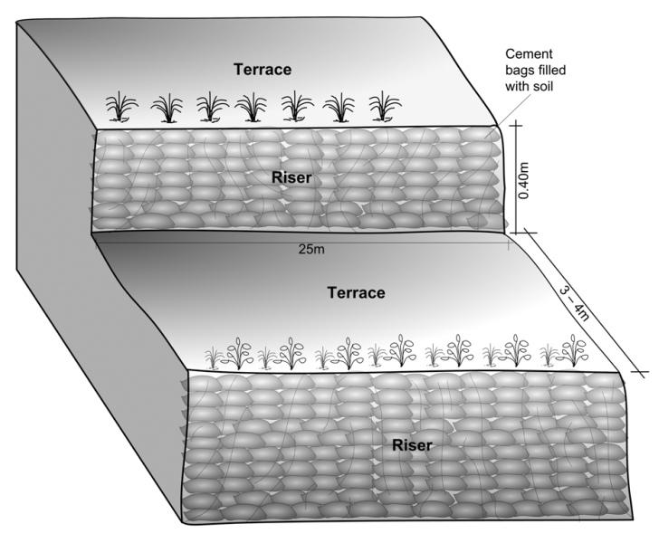
ข้อมูลจำเพาะด้านเทคนิค (แบบแปลนทางเทคนิคของเทคโนโลยี):
Schematric view after intervention [terracing and vegetative measures]
Riser slope: 75 degree
Terrace slope: ~ 2 degree
Location: Kubinde
Technical knowledge required for field staff / advisors: high
Technical knowledge required for land users: moderate
Main technical functions: control of concentrated runoff: impede / retard, reduction of slope angle, reduction of slope length
Secondary technical functions: increase of infiltration, increase / maintain water stored in soil, increase in soil fertility
Vegetative measure: on risers
Vegetative material: T : trees / shrubs, G : grass
Number of plants per (ha): 2500
Vertical interval between rows / strips / blocks (m): 1.5
Spacing between rows / strips / blocks (m): 3 to 4
Vertical interval within rows / strips / blocks (m): 0.25
Vegetative measure: Vegetative material: T : trees / shrubs, G : grass
Vegetative measure: Vegetative material: T : trees / shrubs, G : grass
Vegetative measure: Vegetative material: T : trees / shrubs, G : grass
Trees/ shrubs species: Sunhemp(Crotalaria juncea),Tephrosia (Tephrosia candida) and Flemingia (Flemingia microphylla)
Grass species: Napier(Pennisetum purpureum),Molasses (Melinis minutiflora) and Stylo(Stylosanthes guianensis)
Slope (which determines the spacing indicated above): 5.00%
If the original slope has changed as a result of the Technology, the slope today is (see figure below): 5.00%
Gradient along the rows / strips: 75.00%
Terrace: bench level
Vertical interval between structures (m): 1.5
Width of ditches/pits/dams (m): 3-4
Length of ditches/pits/dams (m): 10-15
Construction material (earth): Cement bag filled with soil, Bamboo nets were used to make risers.
Slope (which determines the spacing indicated above): 30%
If the original slope has changed as a result of the Technology, the slope today is: 5%
Vegetation is used for stabilisation of structures.
ผู้เขียน:
Madhav Dhakal, A. K. Thaku
4.2 ข้อมูลทั่วไปเกี่ยวกับการคำนวณปัจจัยนำเข้าและค่าใช้จ่าย
ระบุสกุลเงินที่ใช้คำนวณค่าใช้จ่าย:
- USD
If relevant, indicate exchange rate from USD to local currency (e.g. 1 USD = 79.9 Brazilian Real): 1 USD =:
-1.0
ระบุค่าเฉลี่ยของค่าจ้างในการจ้างแรงงานต่อวัน:
1.40
4.3 กิจกรรมเพื่อการจัดตั้ง
| กิจกรรม | Timing (season) | |
|---|---|---|
| 1. | Area estimation ( for vegetative measures) | before rainy seasonn/lean period (February) |
| 2. | Selection of fodder grass species | Before rainy season (Feb) |
| 3. | Planting of grasses and hedgerow species on the outward margins | During rainy season. |
| 4. | Establishment of riser, using cement bags (filled with soil) and bamboo culms for terrace stabilisation | Beginning of rainy season(May) |
| 5. | Terrace leveling:The length and width of the terraces depends on the size and shape of the field. Excavate soil from the upper part of the terrace field and use it to build up the lower part behind the terrace riser wallt creat a level plateform/bed. | Beginning of rainy season(May) |
4.4 ค่าใช้จ่ายของปัจจัยนำเข้าที่จำเป็นสำหรับการจัดตั้ง
| ปัจจัยนำเข้า | หน่วย | ปริมาณ | ค่าใช้จ่ายต่อหน่วย | ค่าใช้จ่ายทั้งหมดต่อปัจจัยนำเข้า | %ของค่าใช้จ่ายที่ก่อให้เกิดขึ้นโดยผู้ใช้ที่ดิน | |
|---|---|---|---|---|---|---|
| แรงงาน | Labour | ha | 1.0 | 970.0 | 970.0 | 50.0 |
| อุปกรณ์ | Total costs | ha | 1.0 | 92.0 | 92.0 | 100.0 |
| วัสดุด้านพืช | Seeds | ha | 1.0 | 25.0 | 25.0 | |
| วัสดุด้านพืช | Seedlings | ha | 1.0 | 30.0 | 30.0 | |
| วัสดุด้านพืช | Bamboo | culms | 80.0 | 1.0 | 80.0 | 50.0 |
| วัสดุสำหรับก่อสร้าง | Cement bags | ha | 1.0 | 80.0 | 80.0 | 50.0 |
| อื่น ๆ | Supervision charge | ha | 1.0 | 10.5 | 10.5 | |
| ค่าใช้จ่ายทั้งหมดของการจัดตั้งเทคโนโลยี | 1287.5 | |||||
| Total costs for establishment of the Technology in USD | -1287.5 | |||||
แสดงความคิดเห็น:
Duration of establishment phase: 12 month(s)
4.5 การบำรุงรักษาสภาพหรือกิจกรรมที่เกิดขึ้นเป็นประจำ
| กิจกรรม | ช่วงระยะเวลา/ความถี่ | |
|---|---|---|
| 1. | Hedgerow/grass maintenance: Hedgerows are cut regularly but not | Grass is cut once or twice a month. |
| 2. | (Re)plantation of hedge species if necessary | Before monsoon /1*/year |
| 3. | Surface and riser maintenance: smooth the surface/rills on the | after pre monsoon and after monsoon/2 */ year ,Jun |
4.6 ค่าใช้จ่ายของปัจจัยนำเข้าและกิจกรรมที่เกิดขึ้นเป็นประจำที่ต้องการการบำรุงรักษา (ต่อปี)
| ปัจจัยนำเข้า | หน่วย | ปริมาณ | ค่าใช้จ่ายต่อหน่วย | ค่าใช้จ่ายทั้งหมดต่อปัจจัยนำเข้า | %ของค่าใช้จ่ายที่ก่อให้เกิดขึ้นโดยผู้ใช้ที่ดิน | |
|---|---|---|---|---|---|---|
| แรงงาน | Labour | ha | 1.0 | 310.0 | 310.0 | 100.0 |
| อุปกรณ์ | Tools total costs | ha | 1.0 | 20.0 | 20.0 | 100.0 |
| วัสดุด้านพืช | Seeds | ha | 1.0 | 6.0 | 6.0 | 100.0 |
| วัสดุด้านพืช | Seedlings | ha | 1.0 | 6.0 | 6.0 | 100.0 |
| ค่าใช้จ่ายทั้งหมดของการบำรุงรักษาสภาพเทคโนโลยี | 342.0 | |||||
| Total costs for maintenance of the Technology in USD | -342.0 | |||||
แสดงความคิดเห็น:
Machinery/ tools: Spade, Shovel, spade
All costs and amounts... are very roughly estimated by the technicians and authors.
Costs for structural measures are calculated considering the volume of excavated earth. 1 cubic meter excavated earth = 0.69 USD (labour cost). For vegetative measures it is normally based on daily wage = 1.4 USD as in 2006.
Labour cost is the major expenditure in the initial stage.
costs for tools for establishment are representative for the situation when tools for implementation of the SWC technology are not available (normally they are since the technology does not require very specific tools).
4.7 ปัจจัยสำคัญที่สุดที่มีผลกระทบต่อค่าใช้จ่าย
ปัจจัยสำคัญที่สุดที่มีผลกระทบต่อค่าใช้จ่ายต่างๆ:
In case of projects interested in promoting this technology in the region, the labour cost is the major expenditure in the initial stage.The labour charges are decided by the district soil conservation office.
5. สิ่งแวดล้อมทางธรรมชาติและของมนุษย์
5.1 ภูมิอากาศ
ฝนประจำปี
- < 250 ม.ม.
- 251-500 ม.ม.
- 501-750 ม.ม.
- 751-1,000 ม.ม.
- 1,001-1,500 ม.ม.
- 1,501-2,000 ม.ม.
- 2,001-3,000 ม.ม.
- 3,001-4,000 ม.ม.
- > 4,000 ม.ม.
ระบุปริมาณน้ำฝนเฉลี่ยรายปี (ถ้ารู้) :หน่วย ม.ม.
1304.00
เขตภูมิอากาศเกษตร
- ชื้น
Thermal climate class: subtropics
5.2 สภาพภูมิประเทศ
ค่าเฉลี่ยความลาดชัน:
- ราบเรียบ (0-2%)
- ลาดที่ไม่ชัน (3-5%)
- ปานกลาง (6-10%)
- เป็นลูกคลื่น (11-15%)
- เป็นเนิน (16-30%)
- ชัน (31-60%)
- ชันมาก (>60%)
ธรณีสัณฐาน:
- ที่ราบสูง/ที่ราบ
- สันเขา
- ไหล่เขา
- ไหล่เนินเขา
- ตีนเนิน
- หุบเขา
ระดับความสูง:
- 0-100 เมตร
- 101-500 เมตร
- 501-1,000 เมตร
- 1,001-1,500 เมตร
- 1,501-2,000 เมตร
- 2,001-2,500 เมตร
- 2,501-3,000 เมตร
- 3,001-4,000 เมตร
- > 4,000 เมตร
5.3 ดิน
ค่าเฉลี่ยความลึกของดิน:
- ตื้นมาก (0-20 ซ.ม.)
- ตื้น (21-50 ซ.ม.)
- ลึกปานกลาง (51-80 ซ.ม.)
- ลึก (81-120 ซ.ม.)
- ลึกมาก (>120 ซ.ม.)
เนื้อดิน (ดินชั้นบน):
- ละเอียด/หนัก (ดินเหนียว)
อินทรียวัตถุในดิน:
- ปานกลาง (1-3%)
- ต่ำ (<1%)
(ถ้ามี) ให้แนบคำอธิบายเรื่องดินแบบเต็มหรือระบุข้อมูลที่มีอยู่ เช่น ชนิดของดิน ค่า pH ของดินหรือความเป็นกรดของดิน ความสามารถในการแลกเปลี่ยนประจุบวก ไนโตรเจน ความเค็ม เป็นต้น:
Soil texture (topsoil): Clay loam
Soil fertility is low
Soil drainage / infiltration is good but when rigid surface, then low infiltration
Soil water storage capacity is low - medium
5.4 ความเป็นประโยชน์และคุณภาพของน้ำ
น้ำไหลบ่าที่ผิวดิน:
ไม่ดีหรือไม่มีเลย
คุณภาพน้ำ (ที่ยังไม่ได้บำบัด):
เป็นน้ำเพื่อการดื่มที่ไม่ดี (จำเป็นต้องได้รับการบำบัด)
ความคิดเห็นและข้อมูลจำเพาะเพิ่มเติมเรื่องคุณภาพและปริมาณน้ำ:
Availability of surface water: Sloping land , water available at downstream
Water quality (untreated): More in rainy season (June- September), less in April/May; source: natural spring
5.6 ลักษณะของผู้ใช้ที่ดินที่นำเทคโนโลยีไปปฏิบัติใช้
แนวทางการตลาดของระบบการผลิต:
- เพื่อการยังชีพ (หาเลี้ยงตนเอง)
- mixed (subsistence/ commercial)
รายได้ที่มาจากนอกฟาร์ม:
- 10-50% ของรายได้ทั้งหมด
ระดับของความมั่งคั่งโดยเปรียบเทียบ:
- จน
- พอมีพอกิน
เป็นรายบุคคล/ครัวเรือน:
- เป็นรายบุคคล/ครัวเรือน
ระดับของการใช้เครื่องจักรกล:
- งานที่ใช้แรงกาย
- การใช้กำลังจากสัตว์
เพศ:
- หญิง
- ชาย
ระบุลักษณะอื่นๆที่เกี่ยวข้องของผู้ใช้ที่ดิน:
Land users applying the Technology are mainly common / average land users
Population density: 200-500 persons/km2
Annual population growth: 2% - 3%
2% of the land users are rich and own 10% of the land.
3% of the land users are average wealthy and own 15% of the land (off farm employment).
95% of the land users are poor and own 75% of the land.
Off-farm income specification: In most farm households off-farm income plays at least a minor and increasingly a major role. Occasional opportunities for off-farm income present themselves in the form of daily
Market orientation of production system: For subsistence there is: Rice, maize and wheat. Potato and tomato are for market or subsitence as well.
Level of mechanization: Land preparaion, planting,weeding and harvest is manual labour, but land preparation can also happen with animal traction.
5.7 Average area of land used by land users applying the Technology
- < 0.5 เฮกตาร์
- 0.5-1 เฮกตาร์
- 1-2 เฮกตาร์
- 2-5 เฮกตาร์
- 5-15 เฮกตาร์
- 15-50 เฮกตาร์
- 50-100 เฮกตาร์
- 100-500 เฮกตาร์
- 500-1,000 เฮกตาร์
- 1,000-10,000 เฮกตาร์
- >10,000 เฮกตาร์
พิจารณาว่าเป็นขนาดเล็ก กลาง หรือขนาดใหญ่ (ซึ่งอ้างอิงถึงบริบทระดับท้องถิ่น):
- ขนาดกลาง
แสดงความคิดเห็น:
Land fragmentation due to poulation growth, mostly of rainfed type
5.8 กรรมสิทธิ์ในที่ดิน สิทธิในการใช้ที่ดินและสิทธิในการใช้น้ำ
กรรมสิทธิ์ในที่ดิน:
- รายบุคคล ได้รับสิทธิครอบครอง
สิทธิในการใช้ที่ดิน:
- รายบุคคล
6. ผลกระทบและสรุปคำบอกกล่าว
6.1 ผลกระทบในพื้นที่ดำเนินการ (On-site) จากการใช้เทคโนโลยี
ผลกระทบทางด้านเศรษฐกิจและสังคม
การผลิต
การผลิตพืชผล
แสดงความคิดเห็น/ระบุ:
maize crop by 100%
การผลิตพืชที่ใช้เลี้ยงปศุสัตว์
แสดงความคิดเห็น/ระบุ:
households of neighbouring village benefitted.
คุณภาพพืชที่ใช้เลี้ยงปศุสัตว์
พื้นที่สำหรับการผลิต
รายได้และค่าใช้จ่าย
รายได้จากฟาร์ม
แสดงความคิดเห็น/ระบุ:
by >100% due to higher
ผลกระทบด้านสังคมวัฒนธรรมอื่น ๆ
สถาบันของชุมชน
แสดงความคิดเห็น/ระบุ:
terrace improvement group was formed
Livelihood and human well-being
แสดงความคิดเห็น/ระบุ:
Cropping pattern changed due to which, land users were able to produce more. Farm income and price of land increased.
ผลกระทบด้านนิเวศวิทยา
ดิน
ความชื้นในดิน
แสดงความคิดเห็น/ระบุ:
nearby hedgerows
สิ่งปกคลุมดิน
แสดงความคิดเห็น/ระบุ:
along risers
การสูญเสียดิน
แสดงความคิดเห็น/ระบุ:
due to levelled surface and hedgerow barrier
ผลกระทบด้านนิเวศวิทยาอื่น ๆ
Appearance of pests like rats due to introduction of planted
6.2 ผลกระทบนอกพื้นที่ดำเนินการ (Off-site) จากการใช้เทคโนโลยี
น้ำท่วมพื้นที่ท้ายน้ำ
แสดงความคิดเห็น/ระบุ:
Bigger area needs swc measures
การทับถมของดินตะกอนพื้นที่ท้ายน้ำ
Fodder grass seed distribution
แสดงความคิดเห็น/ระบุ:
through farmer to farmer dissemination
Nutrients downstream
แสดงความคิดเห็น/ระบุ:
due to reduced nutrients leaching on-site
6.3 การเผชิญและความตอบสนองของเทคโนโลยีต่อการเปลี่ยนแปลงสภาพภูมิอากาศที่ค่อยเป็นค่อยไป และสภาพรุนแรงของภูมิอากาศ / ภัยพิบัติ (ที่รับรู้ได้โดยผู้ใช้ที่ดิน)
การเปลี่ยนแปลงสภาพภูมิอากาศที่ค่อยเป็นค่อยไป
การเปลี่ยนแปลงสภาพภูมิอากาศที่ค่อยเป็นค่อยไป
| ฤดู | increase or decrease | เทคโนโลยีมีวิธีการรับมืออย่างไร | |
|---|---|---|---|
| อุณหภูมิประจำปี | เพิ่มขึ้น | ดี |
สภาพรุนแรงของภูมิอากาศ (ภัยพิบัติ)
ภัยพิบัติทางอุตุนิยมวิทยา
| เทคโนโลยีมีวิธีการรับมืออย่างไร | |
|---|---|
| พายุฝนประจำท้องถิ่น | ไม่ค่อยดี |
| พายุลมประจำท้องถิ่น | ดี |
ภัยพิบัติจากสภาพภูมิอากาศ
| เทคโนโลยีมีวิธีการรับมืออย่างไร | |
|---|---|
| ภัยจากฝนแล้ง | ไม่ค่อยดี |
ภัยพิบัติจากน้ำ
| เทคโนโลยีมีวิธีการรับมืออย่างไร | |
|---|---|
| น้ำท่วมตามปกติ (แม่น้ำ) | ไม่ค่อยดี |
ผลลัพธ์ตามมาที่เกี่ยวข้องกับภูมิอากาศอื่น ๆ
ผลลัพธ์ตามมาที่เกี่ยวข้องกับภูมิอากาศอื่น ๆ
| เทคโนโลยีมีวิธีการรับมืออย่างไร | |
|---|---|
| ช่วงการปลูกพืชที่ลดลงมา | ดี |
6.4 การวิเคราะห์ค่าใช้จ่ายและผลประโยชน์ที่ได้รับ
ผลประโยชน์ที่ได้รับเปรียบเทียบกับค่าใช้จ่ายในการจัดตั้งเป็นอย่างไร (จากมุมมองของผู้ใช้ที่ดิน)
ผลตอบแทนระยะสั้น:
เป็นกลางหรือสมดุล
ผลตอบแทนระยะยาว:
ด้านบวก
ผลประโยชน์ที่ได้รับเปรียบเทียบกับค่าใช้จ่ายในการบำรุงรักษาหรือต้นทุนที่เกิดขึ้นซ้ำอีก เป็นอย่างไร (จากมุมมองของผู้ใช้ที่ดิน)
ผลตอบแทนระยะสั้น:
ด้านบวก
ผลตอบแทนระยะยาว:
ด้านบวกอย่างมาก
แสดงความคิดเห็น:
The initial investment is high, but can be recovered within a short period due to yield increment and cash crop production.
6.5 การปรับตัวของเทคโนโลยี
- > 50%
ถ้ามีข้อมูลให้บอกปริมาณด้วย (จำนวนของครัวเรือนหรือครอบคลุมพื้นที่):
16 households in an area of 0.0126 sq km
Of all those who have adopted the Technology, how many did so spontaneously, i.e. without receiving any material incentives/ payments?
- 51-90%
แสดงความคิดเห็น:
6 land user families have adopted the Technology with external material support
10 land user families have adopted the Technology without any external material support
Comments on spontaneous adoption: survey results
There is a little trend towards spontaneous adoption of the Technology
Comments on adoption trend: The number of farmers applying the technology is increasing without further incentives being provided. Others have shown increasing interest in the technology without implementing it due to lack of incentives.
6.7 จุดแข็ง / ข้อได้เปรียบ / โอกาสของเทคโนโลยี
| จุดแข็ง / ข้อได้เปรียบ / โอกาสในทัศนคติของผู้ใช้ที่ดิน |
|---|
|
The price of land increased considerably from NRs 30,000 in 2001 (for 1 ropani – 508.5 sq. m) to between NRs 100, 000 and NRs 150,000 per ropani after the technology was established How can they be sustained / enhanced? The price would increase further if irrigation facilities were installed |
| Pedicels of Tephosia and Sunhemp can be used for firewood. |
| Instead of planting only maize a farmer started planting rice (primary crop) and cash crops like potato / tomato (secondary crops). |
| จุดแข็ง / ข้อได้เปรียบ / โอกาสในทัศนคติของผู้รวบรวมหรือวิทยากรหลัก |
|---|
|
The area of levelled terraces nearly doubled in Kubinde village from 2001 to 2003, which is an indicator of increased awareness of the benefi ts of soil and water conservation. How can they be sustained / enhanced? Experience sharing would help expand the area under improved terraces. |
|
Land productivity increased, maize, potato and bean production increased, vegetables and rice production started. How can they be sustained / enhanced? Irrigation facility could increase the production capacity of the terraces. |
|
Availability of grass/fodder (nitrogen fixing) increased. How can they be sustained / enhanced? Planting horticultural fruits could increase farm incomes and so it should be promoted and more nitrogen fi xing species (preferably local) should be tried out |
6.8 จุดอ่อน / ข้อเสียเปรียบ / ความเสี่ยงของเทคโนโลยีและวิธีการแก้ไข
| จุดอ่อน / ข้อเสียเปรียบ / ความเสี่ยงในทัศนคติของผู้ใช้ที่ดิน | มีวิธีการแก้ไขได้อย่างไร |
|---|---|
| In the fi rst year of implementation, maize production was reduced due to soil amendment |
a phenomenon which is likely to occur with new terrace formation |
| จุดอ่อน / ข้อเสียเปรียบ / ความเสี่ยงในทัศนคติของผู้รวบรวมหรือวิทยากรหลัก | มีวิธีการแก้ไขได้อย่างไร |
|---|---|
| Presently the vegetative technology is confined to terrace margins | it should be extended to the risers also. |
7. การอ้างอิงและการเชื่อมต่อ
7.1 วิธีการและแหล่งข้อมูล
7.2 การอ้างอิงถึงสิ่งตีพิมพ์
หัวข้อ, ผู้เขียน, ปี, หมายเลข ISBN:
ICIMOD (2002) Hydro-meteorological Year Book of Jhikhu Khola Watershed. Kathmandu: ICIMOD
ชื่อเรื่อง ผู้เขียน ปี ISBN:
ICIMOD
หัวข้อ, ผู้เขียน, ปี, หมายเลข ISBN:
Mathema, P.; Singh, B.K. (2003) Soil ErosionStudies in Nepal: Results and Implications. Kathmandu: Government of Nepal, Department of Soil Conservation and Watershed Management
หัวข้อ, ผู้เขียน, ปี, หมายเลข ISBN:
Mathema, P. (2003) Watershed Managementin South Asia. Kathmandu: Government of Nepal, Department of Soil Conservation and Watershed Management
ลิงก์และโมดูล
ขยายทั้งหมด ย่อทั้งหมดลิงก์
ไม่มีลิงก์
โมดูล
ไม่มีโมดูล