Radical Terraces [รวันดา]
- ผู้สร้างสรรค์:
- การอัพเดท:
- ผู้รวบรวม: Desire Kagabo
- ผู้เรียบเรียง: –
- ผู้ตรวจสอบ: David Streiff, Alexandra Gavilano
Amaterasi y'indinganire
technologies_1553 - รวันดา
ดูส่วนย่อย
ขยายทั้งหมด ย่อทั้งหมด1. ข้อมูลทั่วไป
1.2 รายละเอียดที่ติดต่อได้ของผู้รวบรวมและองค์กรที่เกี่ยวข้องในการประเมินและการจัดเตรียมทำเอกสารของเทคโนโลยี
ผู้เชี่ยวชาญ SLM:
ผู้เชี่ยวชาญ SLM:
ชื่อของโครงการซึ่งอำนวยความสะดวกในการทำเอกสารหรือการประเมินเทคโนโลยี (ถ้าเกี่ยวข้อง)
The Transboundary Agro-ecosystem Management Project for the Kagera River Basin (GEF-FAO / Kagera TAMP )ชื่อขององค์กรซึ่งอำนวยความสะดวกในการทำเอกสารหรือการประเมินเทคโนโลยี (ถ้าเกี่ยวข้อง)
FAO Food and Agriculture Organization (FAO Food and Agriculture Organization) - อิตาลีชื่อขององค์กรซึ่งอำนวยความสะดวกในการทำเอกสารหรือการประเมินเทคโนโลยี (ถ้าเกี่ยวข้อง)
Rwanda Agriculture Board (Rwanda Agriculture Board) - รวันดา1.3 เงื่อนไขการใช้ข้อมูลที่ได้บันทึกผ่านทาง WOCAT
ผู้รวบรวมและวิทยากรหลักยอมรับเงื่อนไขเกี่ยวกับการใช้ข้อมูลที่ถูกบันทึกผ่านทาง WOCAT:
ใช่
1.5 Reference to Questionnaire(s) on SLM Approaches (documented using WOCAT)
Top down approach [รวันดา]
This is a top down approach to technology development and dissemination with limited involvement of intended beneficiaries.
- ผู้รวบรวม: Desire Kagabo
2. การอธิบายลักษณะของเทคโนโลยี SLM
2.1 การอธิบายแบบสั้น ๆ ของเทคโนโลยี
คำจำกัดความของเทคโนโลยี:
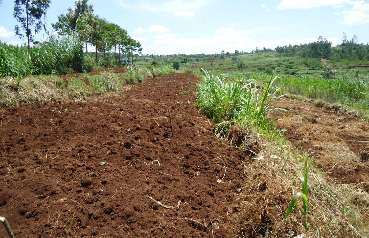
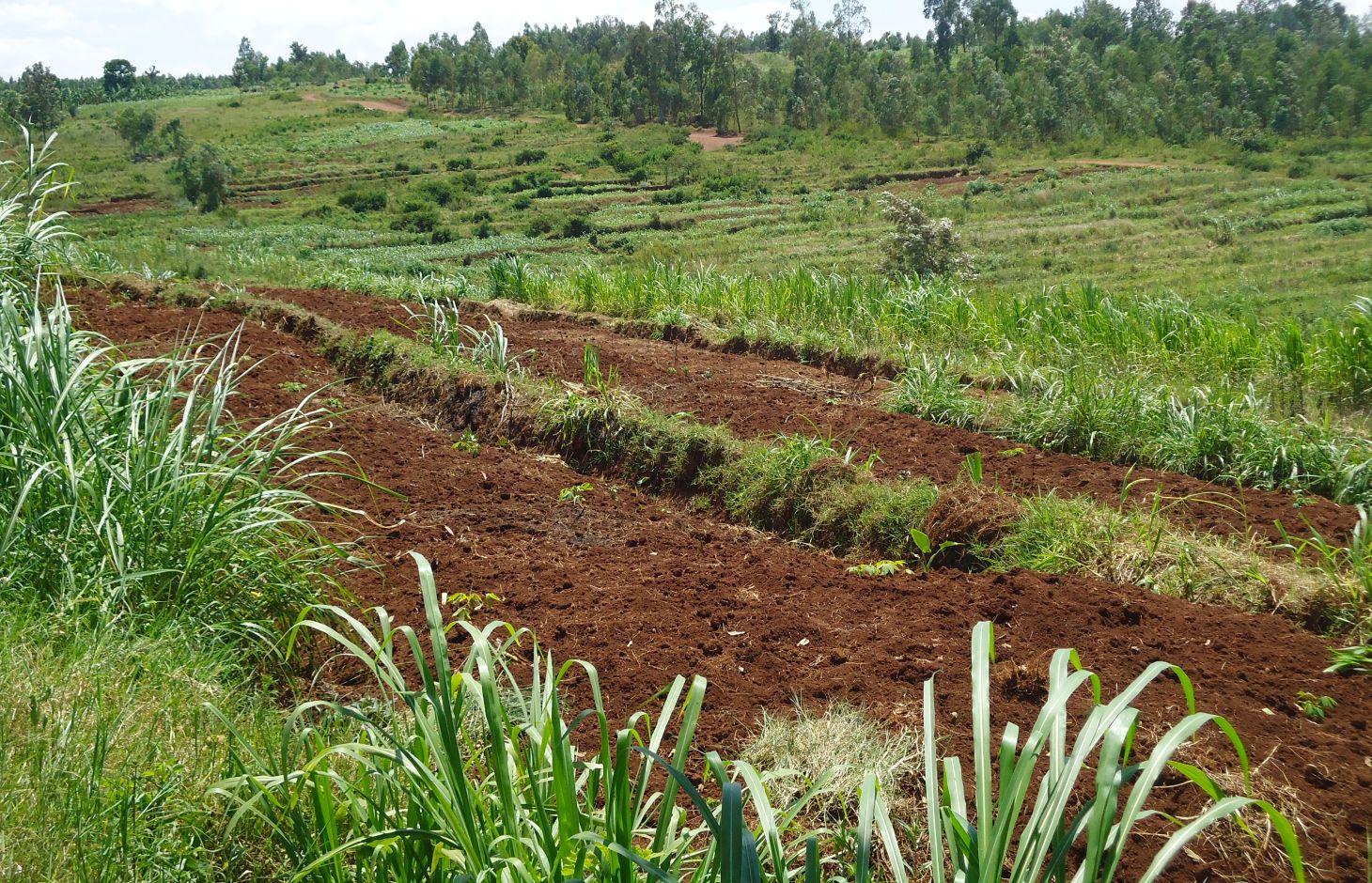
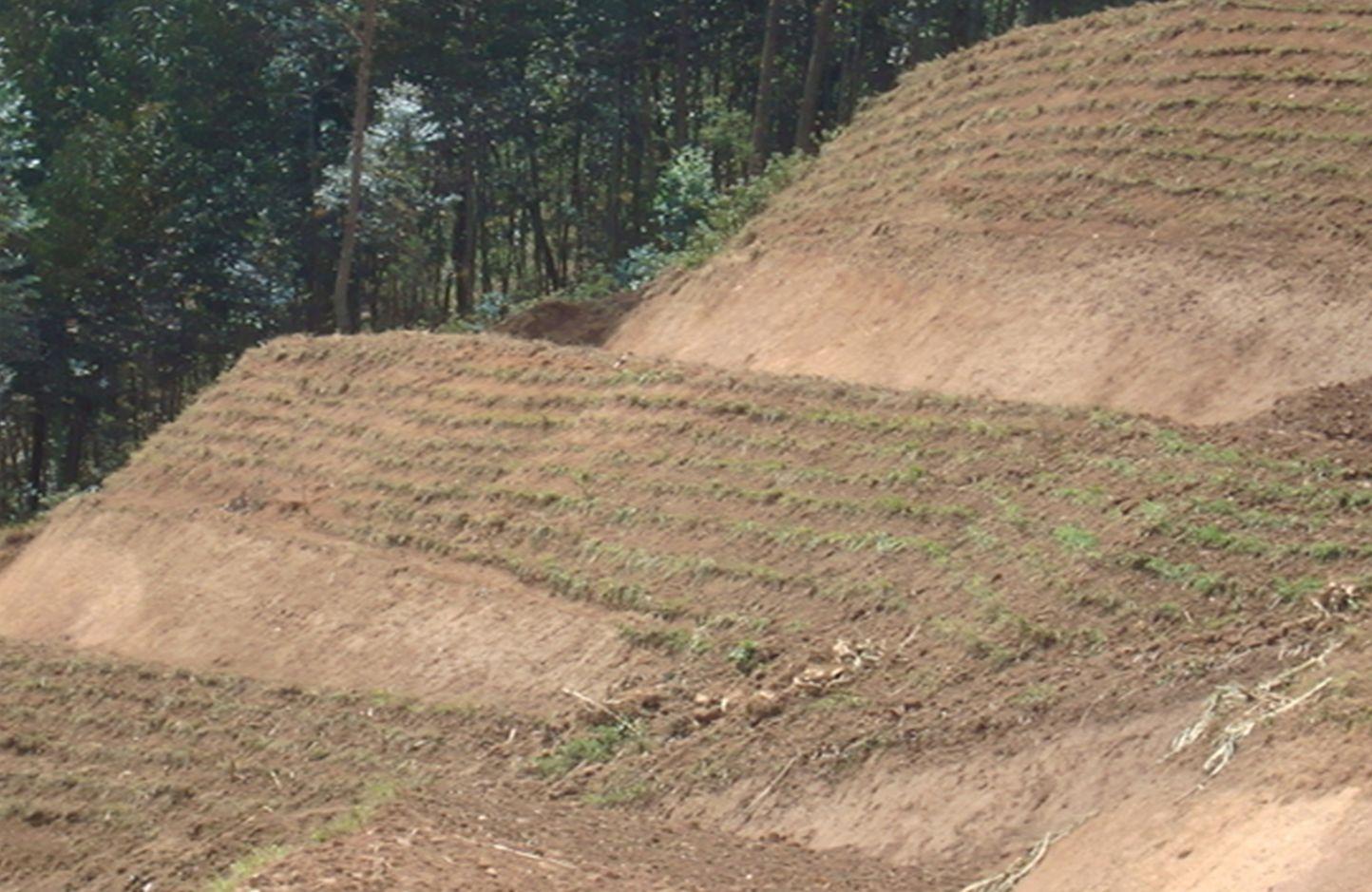
Locally referred to as ‘radical terracing’, the method involves earth moving operations that create reverse-slope bench terraces which have properly shaped risers stabilized with grass or trees on embankment to avoid collapse.
2.2 การอธิบายแบบละเอียดของเทคโนโลยี
คำอธิบาย:
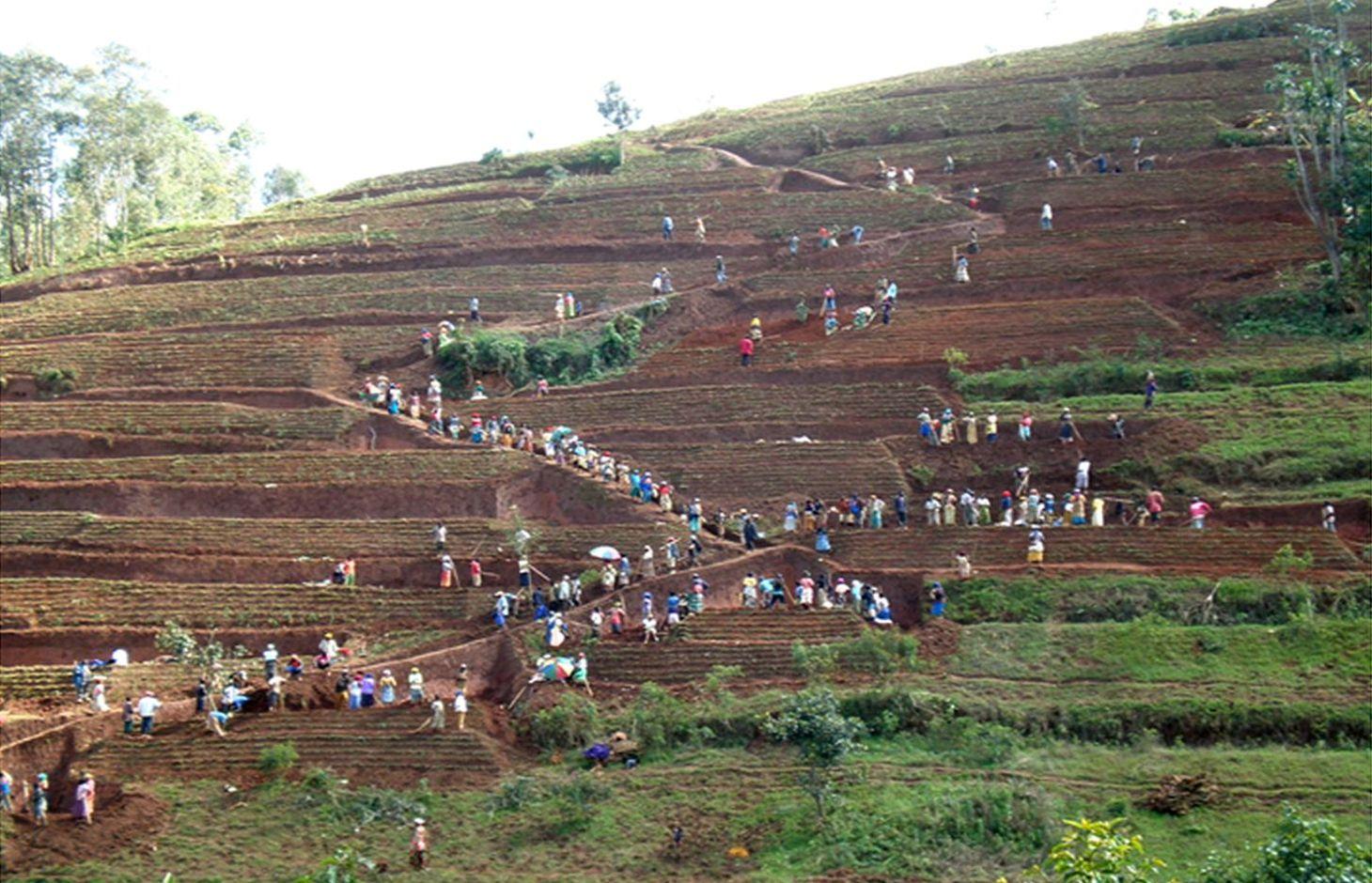
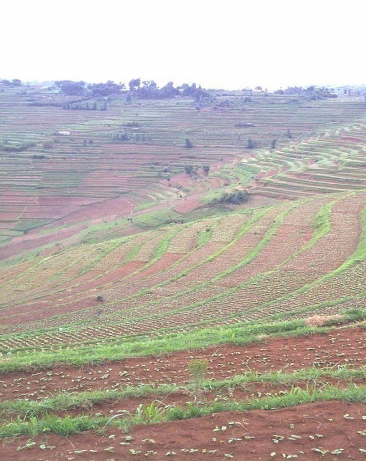
In Rwanda, a unique method of back-slope terracing originally introduced by missionaries growing wheat in the Northern Province in the 1970s, has been widely adopted by smallholder farmers in many parts of the country. The farmers are careful to isolate the topsoil, then they re-work the subsoil to create the required reverse-slope bench, after which the topsoil is spread over the surface. The riser is planted with short runner grass for stabilization, all within the same day. Radical terracing is usually done manually with hoes and shovels, mostly by communal group-work involving hundreds of farmers (see left photo). Thus, a hillside can be terraced in one day. Where radical terraces have been constructed, the effects have been dramatic, achieving optimum water and soil conservation on slopes exceeding 50%, while adoption rates have been quite extensive. This high adoption of radical terracing is related to the existing policies and programs such as land consolidation, land management and crop intensification programs. These policies/programs boost the use of radical terraces by providing farmers more opportunities to easily access inputs such as improved seeds and manure for increasing the productivity of constructed radical terraces. Recent studies (e.g. Fleskens, 2007, Bizoza and de Graaff 2012 and Kagabo et al. 2013) assert that radical terraces in the highlands of Rwanda are only financially viable when the opportunity cost of labour and manure are below the local market price levels and when agriculture area on these radical terraces can be substantially intensified. Ten to 30 metric tons of manure (organic) are required to restore the soil fertility of newly established radical terraces.
Purpose of the Technology: In Rwanda, radical terraces are principally designed (1) to reduce soil losses through enhanced retention and infiltration of runoff, (2) to promote permanent agriculture on steep slopes and (3) to promote land consolidation and intensive land use.
Establishment / maintenance activities and inputs: Newly established radical terraces should be protected at their risers and outlets, especially in the first or second year of the establishment. After establishing a terrace, a riser is shaped and grasses or shrubs/trees are planted soon after. Napier grass is commonly planted and is used as forage for livestock. Risers on radical terraces are seen as a new production niche of forage as a result of land shortage and a strict zero grazing policy.
Natural / human environment: Radical terraces have the potential of improving farmers’ livelihoods and increasing the resilience of a degraded environment.
2.3 รูปภาพของเทคโนโลยี
อัลบั้มสื่อบันทึก
2.5 ประเทศภูมิภาค หรือสถานที่ตั้งที่เทคโนโลยีได้นำไปใช้และได้รับการครอบคลุมโดยการประเมินนี้
ประเทศ:
รวันดา
ภูมิภาค/รัฐ/จังหวัด:
Rwanda
ข้อมูลจำเพาะเพิ่มเติมของสถานที่ตั้ง :
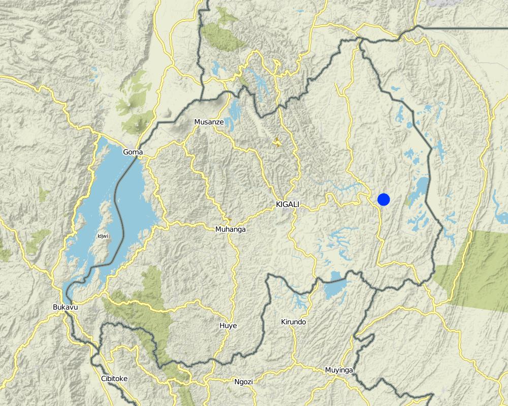
Kayonza District (Eastern province)
ระบุการกระจายตัวของเทคโนโลยี:
- กระจายไปอย่างสม่ำเสมอในพื้นที่
If the Technology is evenly spread over an area, specify area covered (in km2):
10.3
แสดงความคิดเห็น:
Total area covered by the SLM Technology is 10.3 km2.
Map
×2.6 วันที่การดำเนินการ
ถ้าไม่รู้ปีที่แน่นอน ให้ระบุวันที่โดยประมาณ:
- น้อยกว่า 10 ปี (ไม่นานนี้)
2.7 คำแนะนำของเทคโนโลยี
- Government
ความคิดเห็น (ประเภทของโครงการ เป็นต้น) :
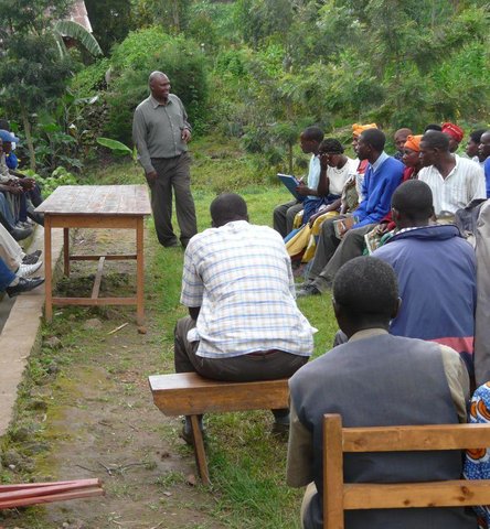
The Government introduced it through local leaders and agronomist. It was established in 2004
3. การจัดประเภทของเทคโนโลยี SLM
3.1 วัตถุประสงค์หลักของเทคโนโลยี
- ลด ป้องกัน ฟื้นฟู การเสื่อมโทรมของที่ดิน
3.2 ประเภทของการใช้ที่ดินในปัจจุบันที่ได้นำเทคโนโลยีไปใช้

พื้นที่ปลูกพืช
- การปลูกพืชล้มลุกอายุปีเดียว
- การปลูกพืชยืนต้นที่ไม่มีเนื้อไม้
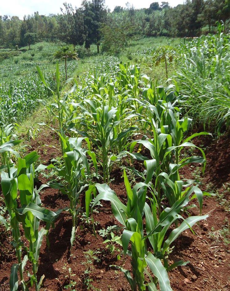
Annual cropping - Specify crops:
- root/tuber crops - sweet potatoes, yams, taro/cocoyam, other
Perennial (non-woody) cropping - Specify crops:
- pineapple
จำนวนของฤดูเพาะปลูกต่อปี:
- 2
ระบุ:
Longest growing period in days: 120; Longest growing period from month to month: September- January; Second longest growing period in days: 90; Second longest growing period from month to month: March - June
แสดงความคิดเห็น:
Major cash crop: Sweet potato and pineapple
Major land use problems (compiler’s opinion): Soil erosion due to high runoff on the steep slopes, deforestation, intensive cultivation and lack of suitable land management methods.
Major land use problems (land users’ perception): Low crop production, soil erosion and lack of fodder
3.4 การใช้น้ำ
การใช้น้ำของที่ดินที่มีการใช้เทคโนโลยีอยู่:
- จากน้ำฝน
3.5 กลุ่ม SLM ที่ตรงกับเทคโนโลยีนี้
- มาตรการปลูกพืชขวางความลาดชัน (cross-slope measure)
3.6 มาตรการ SLM ที่ประกอบกันเป็นเทคโนโลยี

มาตรการอนุรักษ์ด้วยวิธีพืช
- V2: หญ้าและไม้ยืนต้น

มาตรการอนุรักษ์ด้วยโครงสร้าง
- S1: คันดิน
แสดงความคิดเห็น:
Type of vegetative measures: aligned: -contour
3.7 รูปแบบหลักของการเสื่อมโทรมของที่ดินที่ได้รับการแก้ไขโดยเทคโนโลยี

การกัดกร่อนของดินโดยน้ำ
- Wt (Loss of topsoil): การสูญเสียดินชั้นบนหรือการกัดกร่อนที่ผิวดิน
- Wo (Offsite degradation): ผลกระทบนอกพื้นที่
แสดงความคิดเห็น:
Secondary types of degradation addressed: Wo: offsite degradation effects
Main causes of degradation: over-exploitation of vegetation for domestic use, overgrazing (Grazing and fodder), other natural causes (avalanches, volcanic eruptions, mud flows, highly susceptible natural resources, extreme topography, etc.) specify (Extreme topography: steep slopes in many cases over 50%), population pressure (High density (in rural area over 400 inhabitant per ha))
Secondary causes of degradation: deforestation / removal of natural vegetation (incl. forest fires) (Use of cooking energy (fire wood)), poverty / wealth (Farmers have low income and have less access to off farm income or remittances), education, access to knowledge and support services (High rate of irriteracy)
3.8 การป้องกัน การลดลง หรือการฟื้นฟูความเสื่อมโทรมของที่ดิน
ระบุเป้าหมายของเทคโนโลยีกับความเสื่อมโทรมของที่ดิน:
- ลดความเสื่อมโทรมของดิน
แสดงความคิดเห็น:
Secondary goals: prevention of land degradation, rehabilitation / reclamation of denuded land
4. ข้อมูลจำเพาะด้านเทคนิค กิจกรรมการนำไปปฏิบัติใช้ ปัจจัยนำเข้า และค่าใช้จ่าย
4.1 แบบแปลนทางเทคนิคของเทคโนโลยี

ข้อมูลจำเพาะด้านเทคนิค (แบบแปลนทางเทคนิคของเทคโนโลยี):
The farmers are careful to isolate the topsoil, then they re-work the subsoil to create the required reverse-slope bench, after which the topsoil is spread over the surface. The riser is planted with short runner grass for stabilization, all within the same period.
Location: Nyamirama. Kayonza/West/Rwanda
Date: 2013
Technical knowledge required for field staff / advisors: high (Special training should be provided to field staff to be able to make an adequate design)
Technical knowledge required for land users: moderate (Land users are required to only implement the technology under the supervision of field staff)
Main technical functions: control of concentrated runoff: retain / trap
Secondary technical functions: control of concentrated runoff: impede / retard, reduction of slope angle, reduction of slope length, increase of infiltration
Aligned: -contour
Vegetative material: G : grass
Number of plants per (ha): 2000
Vertical interval between rows / strips / blocks (m): 1
Spacing between rows / strips / blocks (m): 4
Vertical interval within rows / strips / blocks (m): 0.2
Width within rows / strips / blocks (m): 0.2
Grass species: Pennisetum
Slope (which determines the spacing indicated above): 35%
If the original slope has changed as a result of the Technology, the slope today is (see figure below): 0%
Gradient along the rows / strips: 0%
Terrace: bench level
Vertical interval between structures (m): 2
Spacing between structures (m): 4
Slope (which determines the spacing indicated above): 20-50%
If the original slope has changed as a result of the Technology, the slope today is: 0%
Lateral gradient along the structure: 0%
Vegetation is used for stabilisation of structures.
ผู้เขียน:
Kagabo Desire and Ngenzi Guy, RAB, 5016 Kigali
4.2 ข้อมูลทั่วไปเกี่ยวกับการคำนวณปัจจัยนำเข้าและค่าใช้จ่าย
อื่นๆ หรือสกุลเงินประจำชาติ (ระบุ):
Rwandan francs
If relevant, indicate exchange rate from USD to local currency (e.g. 1 USD = 79.9 Brazilian Real): 1 USD =:
640.0
ระบุค่าเฉลี่ยของค่าจ้างในการจ้างแรงงานต่อวัน:
1000
4.3 กิจกรรมเพื่อการจัดตั้ง
| กิจกรรม | Timing (season) | |
|---|---|---|
| 1. | Cuttings of grasses | Rain season |
| 2. | Transport of grass cuttings | Rain season |
| 3. | Planting of grass cuttings | Rain season |
| 4. | Land surveying (slope determination, soil structure and texture analysis) | any time |
| 5. | Construction of bunds (risers) with soil from upper and lower sides | dry season |
| 6. | Level terraces bed (surface soil moved from upper to lower part of terraces) | dry season |
| 7. | cutting subsurface soil, leveling and refilling surface soil | dry season |
| 8. | Make lips on edges of terraces | dry season |
| 9. | Compact risers | dry season |
| 10. | Plant grasses including agro-forestery trees. | rainy season |
| 11. | Input/ application of farmyard manure and liming | rainy season |
4.4 ค่าใช้จ่ายของปัจจัยนำเข้าที่จำเป็นสำหรับการจัดตั้ง
| ปัจจัยนำเข้า | หน่วย | ปริมาณ | ค่าใช้จ่ายต่อหน่วย | ค่าใช้จ่ายทั้งหมดต่อปัจจัยนำเข้า | %ของค่าใช้จ่ายที่ก่อให้เกิดขึ้นโดยผู้ใช้ที่ดิน | |
|---|---|---|---|---|---|---|
| แรงงาน | Cuttings of grasses | persons/day/ha | 2.0 | 1000.0 | 2000.0 | 60.0 |
| แรงงาน | Transport of grass cuttings | persons/day/ha | 10.0 | 1000.0 | 10000.0 | |
| แรงงาน | Planting of grass cuttings | persons/day/ha | 20.0 | 1000.0 | 20000.0 | 100.0 |
| แรงงาน | Land surveying (slope determination, soil structure and texture | persons/day/ha | 6.0 | 20000.0 | 120000.0 | |
| ปุ๋ยและสารฆ่า/ยับยั้งการเจริญเติบโตของสิ่งมีชีวิต (ไบโอไซด์) | Lime | kg/ha | 2500.0 | 40.0 | 100000.0 | |
| ปุ๋ยและสารฆ่า/ยับยั้งการเจริญเติบโตของสิ่งมีชีวิต (ไบโอไซด์) | Famyard manure | kg/ha | 30000.0 | 5.0 | 150000.0 | |
| ปุ๋ยและสารฆ่า/ยับยั้งการเจริญเติบโตของสิ่งมีชีวิต (ไบโอไซด์) | Mineral fertilizers | kg/ha | 300.0 | 500.0 | 150000.0 | |
| อื่น ๆ | Labour: Construction of bunds | persons/day/ha | 100.0 | 1000.0 | 100000.0 | |
| อื่น ๆ | Labour: Level terraces bed | persons/day/ha | 250.0 | 1000.0 | 250000.0 | |
| อื่น ๆ | Labour: Cutting subsurface soil | persons/day/ha | 250.0 | 1000.0 | 250000.0 | |
| อื่น ๆ | Labour: Make lips on edges of terraces | persons/day/ha | 10.0 | 1000.0 | 10000.0 | |
| อื่น ๆ | Labour: Compact risers | persons/day/ha | 50.0 | 1000.0 | 50000.0 | |
| อื่น ๆ | Labour: Plant grasses including agro-forestery trees | persons/day/ha | 50.0 | 1000.0 | 50000.0 | |
| ค่าใช้จ่ายทั้งหมดของการจัดตั้งเทคโนโลยี | 1262000.0 | |||||
| Total costs for establishment of the Technology in USD | 1971.88 | |||||
แสดงความคิดเห็น:
Duration of establishment phase: 1 month(s)
4.5 การบำรุงรักษาสภาพหรือกิจกรรมที่เกิดขึ้นเป็นประจำ
| กิจกรรม | ช่วงระยะเวลา/ความถี่ | |
|---|---|---|
| 1. | Weeding | Before crop planting/each cropping season |
| 2. | Manure application | Before crop planting/annually |
| 3. | Grass streaming | Throughout the year |
| 4. | Cleaning of channels and drains | through out the year |
| 5. | Regular repair of destroyed risers | through the year |
4.6 ค่าใช้จ่ายของปัจจัยนำเข้าและกิจกรรมที่เกิดขึ้นเป็นประจำที่ต้องการการบำรุงรักษา (ต่อปี)
| ปัจจัยนำเข้า | หน่วย | ปริมาณ | ค่าใช้จ่ายต่อหน่วย | ค่าใช้จ่ายทั้งหมดต่อปัจจัยนำเข้า | %ของค่าใช้จ่ายที่ก่อให้เกิดขึ้นโดยผู้ใช้ที่ดิน | |
|---|---|---|---|---|---|---|
| แรงงาน | Weeding | persons/day/ha | 5.0 | 1000.0 | 5000.0 | 100.0 |
| แรงงาน | Manure application | persons/day/ha | 10.0 | 1000.0 | 10000.0 | 100.0 |
| แรงงาน | Grass streaming | persons/day/ha | 2.0 | 1000.0 | 2000.0 | 100.0 |
| แรงงาน | Cleaning of channels and drains | persons/day/ha | 10.0 | 300.0 | 3000.0 | 100.0 |
| อื่น ๆ | Labour: Regular repair of destroyed risers | persons/day/ha | 6.0 | 333.3333 | 2000.0 | 100.0 |
| ค่าใช้จ่ายทั้งหมดของการบำรุงรักษาสภาพเทคโนโลยี | 22000.0 | |||||
| Total costs for maintenance of the Technology in USD | 34.38 | |||||
แสดงความคิดเห็น:
Machinery/ tools: Small hoes and machete, Hoes, machete, spade, A.fram, macako and meters.
The cost is calculated using the rate of US dollars at present time and were estimated according to the cost of construction of one radical terrace. At present the labor is 1.6$ per day. This was calculated on 25/07/2011.
4.7 ปัจจัยสำคัญที่สุดที่มีผลกระทบต่อค่าใช้จ่าย
ปัจจัยสำคัญที่สุดที่มีผลกระทบต่อค่าใช้จ่ายต่างๆ:
Factors that affect the cost are labor, soil structure and slope
5. สิ่งแวดล้อมทางธรรมชาติและของมนุษย์
5.1 ภูมิอากาศ
ฝนประจำปี
- < 250 ม.ม.
- 251-500 ม.ม.
- 501-750 ม.ม.
- 751-1,000 ม.ม.
- 1,001-1,500 ม.ม.
- 1,501-2,000 ม.ม.
- 2,001-3,000 ม.ม.
- 3,001-4,000 ม.ม.
- > 4,000 ม.ม.
ข้อมูลจำเพาะ/ความคิดเห็นเรื่องปริมาณน้ำฝน:
1000-1500 mm: September - December
1500-2000 mm: February - June
เขตภูมิอากาศเกษตร
- กึ่งชุ่มชื้น
Thermal climate class: tropics. All months are above 18 degree C.
5.2 สภาพภูมิประเทศ
ค่าเฉลี่ยความลาดชัน:
- ราบเรียบ (0-2%)
- ลาดที่ไม่ชัน (3-5%)
- ปานกลาง (6-10%)
- เป็นลูกคลื่น (11-15%)
- เป็นเนิน (16-30%)
- ชัน (31-60%)
- ชันมาก (>60%)
ธรณีสัณฐาน:
- ที่ราบสูง/ที่ราบ
- สันเขา
- ไหล่เขา
- ไหล่เนินเขา
- ตีนเนิน
- หุบเขา
ระดับความสูง:
- 0-100 เมตร
- 101-500 เมตร
- 501-1,000 เมตร
- 1,001-1,500 เมตร
- 1,501-2,000 เมตร
- 2,001-2,500 เมตร
- 2,501-3,000 เมตร
- 3,001-4,000 เมตร
- > 4,000 เมตร
5.3 ดิน
ค่าเฉลี่ยความลึกของดิน:
- ตื้นมาก (0-20 ซ.ม.)
- ตื้น (21-50 ซ.ม.)
- ลึกปานกลาง (51-80 ซ.ม.)
- ลึก (81-120 ซ.ม.)
- ลึกมาก (>120 ซ.ม.)
เนื้อดิน (ดินชั้นบน):
- หยาบ/เบา (ดินทราย)
- ปานกลาง (ดินร่วน ทรายแป้ง)
อินทรียวัตถุในดิน:
- ต่ำ (<1%)
(ถ้ามี) ให้แนบคำอธิบายเรื่องดินแบบเต็มหรือระบุข้อมูลที่มีอยู่ เช่น ชนิดของดิน ค่า pH ของดินหรือความเป็นกรดของดิน ความสามารถในการแลกเปลี่ยนประจุบวก ไนโตรเจน ความเค็ม เป็นต้น:
Soil fertility is low
Soil drainage / infiltration is good
Soil water storage capacity is low - medium
5.4 ความเป็นประโยชน์และคุณภาพของน้ำ
ระดับน้ำใต้ดิน:
> 50 เมตร
น้ำไหลบ่าที่ผิวดิน:
ไม่ดีหรือไม่มีเลย
คุณภาพน้ำ (ที่ยังไม่ได้บำบัด):
เป็นน้ำเพื่อการดื่มที่ไม่ดี (จำเป็นต้องได้รับการบำบัด)
ความคิดเห็นและข้อมูลจำเพาะเพิ่มเติมเรื่องคุณภาพและปริมาณน้ำ:
Water quality (untreated): Good drinking water available but very far to fetch.
5.5 ความหลากหลายทางชีวภาพ
ความหลากหลายทางชนิดพันธุ์:
- ต่ำ
5.6 ลักษณะของผู้ใช้ที่ดินที่นำเทคโนโลยีไปปฏิบัติใช้
แนวทางการตลาดของระบบการผลิต:
- เพื่อการยังชีพ (หาเลี้ยงตนเอง)
- ทำการค้า/การตลาด
รายได้ที่มาจากนอกฟาร์ม:
- < 10% ของรายได้ทั้งหมด
ระดับของความมั่งคั่งโดยเปรียบเทียบ:
- ยากจนมาก
- จน
เป็นรายบุคคล/ครัวเรือน:
- เป็นรายบุคคล/ครัวเรือน
ระดับของการใช้เครื่องจักรกล:
- งานที่ใช้แรงกาย
เพศ:
- หญิง
- ชาย
ระบุลักษณะอื่นๆที่เกี่ยวข้องของผู้ใช้ที่ดิน:
Population density: 50-100 persons/km2
Annual population growth: 2% - 3%
75% of the land users are poor and own 60% of the land.
25% of the land users are poor and own 40% of the land.
5.7 Average area of land used by land users applying the Technology
- < 0.5 เฮกตาร์
- 0.5-1 เฮกตาร์
- 1-2 เฮกตาร์
- 2-5 เฮกตาร์
- 5-15 เฮกตาร์
- 15-50 เฮกตาร์
- 50-100 เฮกตาร์
- 100-500 เฮกตาร์
- 500-1,000 เฮกตาร์
- 1,000-10,000 เฮกตาร์
- >10,000 เฮกตาร์
พิจารณาว่าเป็นขนาดเล็ก กลาง หรือขนาดใหญ่ (ซึ่งอ้างอิงถึงบริบทระดับท้องถิ่น):
- ขนาดเล็ก
5.8 กรรมสิทธิ์ในที่ดิน สิทธิในการใช้ที่ดินและสิทธิในการใช้น้ำ
กรรมสิทธิ์ในที่ดิน:
- รายบุคคล ไม่ได้รับสิทธิครอบครอง
- รายบุคคล ได้รับสิทธิครอบครอง
สิทธิในการใช้ที่ดิน:
- รายบุคคล
สิทธิในการใช้น้ำ:
- เข้าถึงได้แบบเปิด (ไม่ได้จัดระเบียบ)
- เกี่ยวกับชุมชน (ถูกจัดระเบียบ)
5.9 การเข้าถึงบริการและโครงสร้างพื้นฐาน
สุขภาพ:
- จน
- ปานกลาง
- ดี
การศึกษา:
- จน
- ปานกลาง
- ดี
ความช่วยเหลือทางด้านเทคนิค:
- จน
- ปานกลาง
- ดี
การจ้างงาน (เช่น ภายนอกฟาร์ม):
- จน
- ปานกลาง
- ดี
ตลาด:
- จน
- ปานกลาง
- ดี
พลังงาน:
- จน
- ปานกลาง
- ดี
ถนนและการขนส่ง:
- จน
- ปานกลาง
- ดี
น้ำดื่มและการสุขาภิบาล:
- จน
- ปานกลาง
- ดี
บริการด้านการเงิน:
- จน
- ปานกลาง
- ดี
6. ผลกระทบและสรุปคำบอกกล่าว
6.1 ผลกระทบในพื้นที่ดำเนินการ (On-site) จากการใช้เทคโนโลยี
ผลกระทบทางด้านเศรษฐกิจและสังคม
การผลิต
การผลิตพืชผล
การผลิตพืชที่ใช้เลี้ยงปศุสัตว์
พื้นที่สำหรับการผลิต
แสดงความคิดเห็น/ระบุ:
Reduce crop area
รายได้และค่าใช้จ่าย
ค่าใช่จ่ายของปัจจัยการผลิตทางการเกษตร
แสดงความคิดเห็น/ระบุ:
Require high quantity of FYM and mineral fertilizers
ผลกระทบด้านสังคมวัฒนธรรมอื่น ๆ
ความมั่นคงด้านอาหาร / พึ่งตนเองได้
SLM หรือความรู้เรื่องความเสื่อมโทรมของที่ดิน
livelihood and human well-being
แสดงความคิดเห็น/ระบุ:
The technology is newly established and the soil need enough farmyard manure and inputs to re-stabilize and regain its fertility
ผลกระทบด้านนิเวศวิทยา
วัฐจักรน้ำหรือน้ำบ่า
ปริมาณน้ำ
น้ำไหลบ่าที่ผิวดิน
ดิน
ความชื้นในดิน
การสูญเสียดิน
ลดความเสี่ยงของภัยพิบัติ
ผลกระทบของพายุไซโคลน พายุฝน
การปล่อยคาร์บอนและก๊าซเรือนกระจก
ผลกระทบด้านนิเวศวิทยาอื่น ๆ
disturbance of fertile top soil
biodiversity
6.2 ผลกระทบนอกพื้นที่ดำเนินการ (Off-site) จากการใช้เทคโนโลยี
น้ำท่วมพื้นที่ท้ายน้ำ
การทับถมของดินตะกอนพื้นที่ท้ายน้ำ
ความเสียหายต่อพื้นที่เพาะปลูกของเพื่อนบ้าน
ความเสียหายต่อโครงสร้างพื้นฐานของรัฐหรือของเอกชน
6.3 การเผชิญและความตอบสนองของเทคโนโลยีต่อการเปลี่ยนแปลงสภาพภูมิอากาศที่ค่อยเป็นค่อยไป และสภาพรุนแรงของภูมิอากาศ / ภัยพิบัติ (ที่รับรู้ได้โดยผู้ใช้ที่ดิน)
การเปลี่ยนแปลงสภาพภูมิอากาศที่ค่อยเป็นค่อยไป
การเปลี่ยนแปลงสภาพภูมิอากาศที่ค่อยเป็นค่อยไป
| ฤดู | increase or decrease | เทคโนโลยีมีวิธีการรับมืออย่างไร | |
|---|---|---|---|
| อุณหภูมิประจำปี | เพิ่มขึ้น | ดี |
สภาพรุนแรงของภูมิอากาศ (ภัยพิบัติ)
ภัยพิบัติทางอุตุนิยมวิทยา
| เทคโนโลยีมีวิธีการรับมืออย่างไร | |
|---|---|
| พายุฝนประจำท้องถิ่น | ไม่ค่อยดี |
ภัยพิบัติจากสภาพภูมิอากาศ
| เทคโนโลยีมีวิธีการรับมืออย่างไร | |
|---|---|
| ภัยจากฝนแล้ง | ดี |
ภัยพิบัติจากน้ำ
| เทคโนโลยีมีวิธีการรับมืออย่างไร | |
|---|---|
| น้ำท่วมตามปกติ (แม่น้ำ) | ไม่ค่อยดี |
ผลลัพธ์ตามมาที่เกี่ยวข้องกับภูมิอากาศอื่น ๆ
ผลลัพธ์ตามมาที่เกี่ยวข้องกับภูมิอากาศอื่น ๆ
| เทคโนโลยีมีวิธีการรับมืออย่างไร | |
|---|---|
| ช่วงการปลูกพืชที่ลดลงมา | ไม่ทราบ |
| land slides | ไม่ค่อยดี |
6.4 การวิเคราะห์ค่าใช้จ่ายและผลประโยชน์ที่ได้รับ
ผลประโยชน์ที่ได้รับเปรียบเทียบกับค่าใช้จ่ายในการจัดตั้งเป็นอย่างไร (จากมุมมองของผู้ใช้ที่ดิน)
ผลตอบแทนระยะสั้น:
ด้านลบ
ผลตอบแทนระยะยาว:
ด้านบวกอย่างมาก
ผลประโยชน์ที่ได้รับเปรียบเทียบกับค่าใช้จ่ายในการบำรุงรักษาหรือต้นทุนที่เกิดขึ้นซ้ำอีก เป็นอย่างไร (จากมุมมองของผู้ใช้ที่ดิน)
ผลตอบแทนระยะสั้น:
ด้านลบอย่างมาก
ผลตอบแทนระยะยาว:
เป็นกลางหรือสมดุล
6.5 การปรับตัวของเทคโนโลยี
- > 50%
ถ้ามีข้อมูลให้บอกปริมาณด้วย (จำนวนของครัวเรือนหรือครอบคลุมพื้นที่):
150 households covering 75 percent of stated area
Of all those who have adopted the Technology, how many did so spontaneously, i.e. without receiving any material incentives/ payments?
- 0-10%
แสดงความคิดเห็น:
140 land user families have adopted the Technology with external material support
10 land user families have adopted the Technology without any external material support
There is a little trend towards spontaneous adoption of the Technology
Comments on adoption trend: The real advantages of the technology are observed after 5 to 6 years with good maintenance of structures
6.7 จุดแข็ง / ข้อได้เปรียบ / โอกาสของเทคโนโลยี
| จุดแข็ง / ข้อได้เปรียบ / โอกาสในทัศนคติของผู้ใช้ที่ดิน |
|---|
|
It reduces soil runoff How can they be sustained / enhanced? Good maintenance of structures |
| จุดแข็ง / ข้อได้เปรียบ / โอกาสในทัศนคติของผู้รวบรวมหรือวิทยากรหลัก |
|---|
|
It controls soil erosion How can they be sustained / enhanced? There is a need to plant grasses or trees on risers to stabilize terraces |
|
It increases soil water holding capacity How can they be sustained / enhanced? Organic manure should be added to the terrace to effectively increase the soil water holding capacity. |
|
It increases fodder availability as new niches for fodder production are created. How can they be sustained / enhanced? High value nutritive fodder should be planted (napier grass, calliadra, tripsucum, etc.) on risers |
|
It increases crop productivity How can they be sustained / enhanced? Terraces should be well maintained by providing more inputs and regular maintenance of bench struactures |
6.8 จุดอ่อน / ข้อเสียเปรียบ / ความเสี่ยงของเทคโนโลยีและวิธีการแก้ไข
| จุดอ่อน / ข้อเสียเปรียบ / ความเสี่ยงในทัศนคติของผู้ใช้ที่ดิน | มีวิธีการแก้ไขได้อย่างไร |
|---|---|
| It reduces the cropped land | Farmers should be supported in accessing high value crops and inputs to maximize crop yield. |
| จุดอ่อน / ข้อเสียเปรียบ / ความเสี่ยงในทัศนคติของผู้รวบรวมหรือวิทยากรหลัก | มีวิธีการแก้ไขได้อย่างไร |
|---|---|
| The establishment of radical terraces is expensive | The construction of radical terraces should be subsided by the government. |
| The initial soil structure is disturbed (lost of soil organic matter) | Heavy investments are needed to replenish the soil fertility, especially by adding organic manure. |
| The establishment of radical terraces decreases cropped land. | Grow high value crops and use adequate quantity of inputs. |
| With poor maintenance or poor design of radical terraces, landslides may occur. | To be much more rigorous in the design and implementation/development of terraces by making sure that professionals are involved in the whole process of establishing terraces. |
7. การอ้างอิงและการเชื่อมต่อ
7.2 การอ้างอิงถึงสิ่งตีพิมพ์
หัวข้อ, ผู้เขียน, ปี, หมายเลข ISBN:
Kagera TAMp project website
ชื่อเรื่อง ผู้เขียน ปี ISBN:
http://www.fao.org/nr/kagera/en/
ลิงก์และโมดูล
ขยายทั้งหมด ย่อทั้งหมดลิงก์
Top down approach [รวันดา]
This is a top down approach to technology development and dissemination with limited involvement of intended beneficiaries.
- ผู้รวบรวม: Desire Kagabo
โมดูล
ไม่มีโมดูล