Multi-specific plantation of semiarid woody species on terraces with stone walls in ravines and gullies [สเปน]
- ผู้สร้างสรรค์:
- การอัพเดท:
- ผู้รวบรวม: Susana Bautista
- ผู้เรียบเรียง: –
- ผู้ตรวจสอบ: Fabian Ottiger, Alexandra Gavilano
Plantación pluriespecífica de especies leñosas de ambiente semiárido en terrazas con pared de piedra sobre barrancos y c
technologies_1649 - สเปน
ดูส่วนย่อย
ขยายทั้งหมด ย่อทั้งหมด1. ข้อมูลทั่วไป
1.2 รายละเอียดที่ติดต่อได้ของผู้รวบรวมและองค์กรที่เกี่ยวข้องในการประเมินและการจัดเตรียมทำเอกสารของเทคโนโลยี
ผู้เชี่ยวชาญ SLM:
Urgeghe Anna Maria
Universidad de Alicante
สเปน
ผู้เชี่ยวชาญ SLM:
Guixot Lorena
Universidad de Alicante
สเปน
Government official:
Bartual Miguel
Conselleria de infrastructuras, territorio y medioambiente
สเปน
ชื่อของโครงการซึ่งอำนวยความสะดวกในการทำเอกสารหรือการประเมินเทคโนโลยี (ถ้าเกี่ยวข้อง)
Catastrophic shifts in drylands (EU-CASCADE)ชื่อขององค์กรซึ่งอำนวยความสะดวกในการทำเอกสารหรือการประเมินเทคโนโลยี (ถ้าเกี่ยวข้อง)
Conselleria de infrastructuras, territorio y medioambiente - สเปนชื่อขององค์กรซึ่งอำนวยความสะดวกในการทำเอกสารหรือการประเมินเทคโนโลยี (ถ้าเกี่ยวข้อง)
Universidad de Alicante (Universidad de Alicante) - สเปน1.3 เงื่อนไขการใช้ข้อมูลที่ได้บันทึกผ่านทาง WOCAT
ผู้รวบรวมและวิทยากรหลักยอมรับเงื่อนไขเกี่ยวกับการใช้ข้อมูลที่ถูกบันทึกผ่านทาง WOCAT:
ใช่
2. การอธิบายลักษณะของเทคโนโลยี SLM
2.1 การอธิบายแบบสั้น ๆ ของเทคโนโลยี
คำจำกัดความของเทคโนโลยี:
Plantation of native semiarid woody species on small terraces with stone walls on ravines and gullies
2.2 การอธิบายแบบละเอียดของเทคโนโลยี
คำอธิบาย:
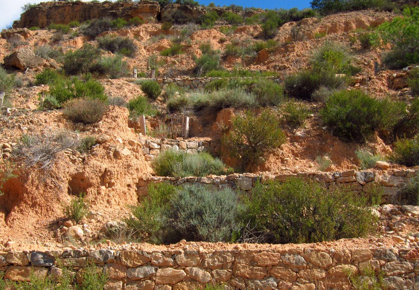
This technology is a restoration technology implemented on ravines and gullies in a degraded semiarid mountain range. The restoration technology consisted of a plantation of seedlings of a variety of native woody species, mostly shrubs, on terraces with stone walls. Using planting holes, one or two rows of seedlings were established on each terrace; Seedlings were protected from extreme radiation and predation by biodegradable seedling shelters. The target area was highly degraded due to long-term overexploitation of resources under harsh environmental conditions. Failed previous reforestation actions on bench terraces led to further degradation in some areas. Degradation resulted in lack of riparian vegetation on the ramblas (ravines with intermittent flow), soil erosion, development of gullies, and frequent floods. To address this problem, the Forest Administration implemented a restoration program on the ravines and gullies of the south-facing side of the Albatera-Crevillente mountain range. The program was implemented in 2006-07.
Purpose of the Technology: The purpose of the restoration was control of concentrated erosion in gullies and ravines; mitigation of landscape degradation; flood prevention; restoration of diversity and cover of vegetation on a degraded semiarid mountain range.
Natural / human environment: The target area is the south-facing side of a mountain range in a semiarid area of Southeast Spain. Exploitation of resources over centuries, mostly grazing and wood gathering, under harsh environmental conditions, led to very low plant cover, mostly consisting of dwarf shrubs sparsed in a matrix of bare soil, lack of riparian vegetation on the ramblas (ravines with intermittent flow), soil erosion, development of gullies, and frequent floods. The exploitation of the land was drastically reduced during the second half of the XXth century due to the general rural land abandonment trend that started in Spain around the 1950’s driven by critical socio-economic changes such as the use of fossil fuels and the sharp increase in activity in the tourism and services business sectors, mostly in the coast land. However, despite the reduction, or even complete abandonment, of rural activity on the mountain range area, there was no sign of spontaneous recovery from degradation. Soil erosion and floods were of major concern for the resource managers in the area (Public Forest Administration), and a number of reforestation and restoration programs have been implemented in the area, with varying degree of success. In more recent decades, new pressures appeared in the mountain area, such as agricultural expansion into the range area (1970s), mining activities (late 1990’s - early 2000’s), and urbanization (2000s). Rural tourism and recreation are new activities in the mountain range area. For the time being, the intensity of these activities is low to moderate. However there is already some evidence of incipient degradation associated to recreation, and some regulation is being demanded by environmental NGOs
2.3 รูปภาพของเทคโนโลยี
อัลบั้มสื่อบันทึก
2.5 ประเทศภูมิภาค หรือสถานที่ตั้งที่เทคโนโลยีได้นำไปใช้และได้รับการครอบคลุมโดยการประเมินนี้
ประเทศ:
สเปน
ภูมิภาค/รัฐ/จังหวัด:
Spain/Alicante
ข้อมูลจำเพาะเพิ่มเติมของสถานที่ตั้ง :
Albatera
ระบุการกระจายตัวของเทคโนโลยี:
- กระจายไปอย่างสม่ำเสมอในพื้นที่
If precise area is not known, indicate approximate area covered:
- 1-10 ตร.กม.
แสดงความคิดเห็น:
Total area covered by the SLM Technology is 5.7 km2.
The MST was applied on the south-facing side of Albatera-Crevillente mountain range. The area consisted of a sequence of southeast and southwest-facing slopes with small ravines (barrrancos) in between. The MST was specifically applied to ravines and gullies.
2.6 วันที่การดำเนินการ
ถ้าไม่รู้ปีที่แน่นอน ให้ระบุวันที่โดยประมาณ:
- น้อยกว่า 10 ปี (ไม่นานนี้)
2.7 คำแนะนำของเทคโนโลยี
ให้ระบุว่าเทคโนโลยีถูกแนะนำเข้ามาอย่างไร:
- ทางโครงการหรือจากภายนอก
3. การจัดประเภทของเทคโนโลยี SLM
3.1 วัตถุประสงค์หลักของเทคโนโลยี
- ลด ป้องกัน ฟื้นฟู การเสื่อมโทรมของที่ดิน
- รักษาสภาพหรือปรับปรุงความหลากหลายทางชีวภาพ
- ลดความเสี่ยงของภัยพิบัติ
3.2 ประเภทของการใช้ที่ดินในปัจจุบันที่ได้นำเทคโนโลยีไปใช้
Land use mixed within the same land unit:
ใช่

ป่า/พื้นที่ทำไม้
ผลิตภัณฑ์และบริการ:
- ผลิตภัณฑ์อื่น ๆ จากป่า
- การอนุรักษ์ / ป้องกันธรรมชาติ
- นันทนาการ / การท่องเที่ยว

ที่ดินที่ไม่ให้ผลผลิต
ระบุ:
Trees/ shrubs species: Olea europaea var sylvestris, Ephedra fragilis, Pistacia lentiscus and Pinus halepensis
แสดงความคิดเห็น:
Major land use problems (compiler’s opinion): Erosion, water scarcity, low productivity, loss of soil functions (water infiltration, nutrient cycling), low biodiversity, loss of landscape structure, flood risk
Major land use problems (land users’ perception): Low productivity, aridity, limiting conditions for tree cover, erosion
Plantation forestry: Without exploitation
Forest products and services: nature conservation / protection, recreation / tourism
Future (final) land use (after implementation of SLM Technology): Forests / woodlands: Fn: Natural
3.3 Has land use changed due to the implementation of the Technology?
แสดงความคิดเห็น:
The program was implemented in 2006-07.
3.5 กลุ่ม SLM ที่ตรงกับเทคโนโลยีนี้
- การปรับปรุงดิน / พืชคลุมดิน
- มาตรการปลูกพืชขวางความลาดชัน (cross-slope measure)
3.6 มาตรการ SLM ที่ประกอบกันเป็นเทคโนโลยี

มาตรการอนุรักษ์ด้วยวิธีพืช
- V1: ต้นไม้และพุ่มไม้คลุมดิน

มาตรการอนุรักษ์ด้วยโครงสร้าง
- S1: คันดิน
3.7 รูปแบบหลักของการเสื่อมโทรมของที่ดินที่ได้รับการแก้ไขโดยเทคโนโลยี

การกัดกร่อนของดินโดยน้ำ
- Wg (Gully erosion): การกัดกร่อนแบบร่องธารหรือการทำให้เกิดร่องน้ำเซาะ
- Wo (Offsite degradation): ผลกระทบนอกพื้นที่

การเสื่อมโทรมของดินทางด้านชีวภาพ
- Bc (Reduction of vegetation cover): การลดลงของจำนวนพืชที่ปกคลุมดิน
- Bq (Quantity/biomass decline): การลดลงของปริมาณหรือมวลชีวภาพ
- Bs (Quality and species composition): องค์ประกอบหรือความหลากหลายทางคุณภาพและชนิดพันธุ์ลดลง

การเสื่อมโทรมของน้ำ
- Ha (Aridification): การเกิดความแห้งแล้ง
- Hs (Change in quantity of surface water): การเปลี่ยนแปลงปริมาณของน้ำที่ผิวดิน
แสดงความคิดเห็น:
Main type of degradation addressed: Wg: gully erosion / gullying, Wo: offsite degradation effects
Secondary types of degradation addressed: Bc: reduction of vegetation cover, Bq: quantity / biomass decline, Bs: quality and species composition /diversity decline, Ha: aridification, Hs: change in quantity of surface water
Main causes of degradation: deforestation / removal of natural vegetation (incl. forest fires) (Agricultural land expansion. Starting in 1965, peaking in late 1970’s), over-exploitation of vegetation for domestic use (Peaking during 1940’s), poverty / wealth (Poverty)
Secondary causes of degradation: overgrazing (Peaking during 1940’s), industrial activities and mining (Late 1990’s - early 2000’s), urbanisation and infrastructure development (Last 10 years), droughts, population pressure (Relative demographic pressure given the low productivity of the land), land tenure (Lack of proper land demarcation until late 1990’s - early 2000’s, leading to misuse and mismanagement of public land)
3.8 การป้องกัน การลดลง หรือการฟื้นฟูความเสื่อมโทรมของที่ดิน
แสดงความคิดเห็น:
Main goals: rehabilitation / reclamation of denuded land
Secondary goals: prevention of land degradation, mitigation / reduction of land degradation
4. ข้อมูลจำเพาะด้านเทคนิค กิจกรรมการนำไปปฏิบัติใช้ ปัจจัยนำเข้า และค่าใช้จ่าย
4.1 แบบแปลนทางเทคนิคของเทคโนโลยี
ข้อมูลจำเพาะด้านเทคนิค (แบบแปลนทางเทคนิคของเทคโนโลยี):
Technical knowledge required for field staff / advisors: moderate (Needed for field implementation: soil preparation, planting techniques)
Technical knowledge required for land users: high (Land users are Forest Administration staff. High technical knowledge is require for the design of technology implementation)
Main technical functions: control of dispersed runoff: retain / trap, control of dispersed runoff: impede / retard, control of concentrated runoff: retain / trap, control of concentrated runoff: impede / retard, reduction of slope angle
Secondary technical functions: control of raindrop splash, reduction of slope length, improvement of ground cover, increase of surface roughness, improvement of surface structure (crusting, sealing), improvement of topsoil structure (compaction), stabilisation of soil (eg by tree roots against land slides), increase in organic matter, increase in nutrient availability (supply, recycling,…), increase of infiltration, increase / maintain water stored in soil, sediment retention / trapping, sediment harvesting, increase of biomass (quantity), promotion of vegetation species and varieties (quality, eg palatable fodder)
Vegetative measure: Staggered pattern
Vegetative material: T : trees / shrubs
Number of plants per (ha): 610
Spacing between rows / strips / blocks (m): 5
Vertical interval within rows / strips / blocks (m): 5
Vegetative measure: Vegetative material: T : trees / shrubs
Vegetative measure: Vegetative material: T : trees / shrubs
Vegetative measure: Vegetative material: T : trees / shrubs
Trees/ shrubs species: Olea europaea var sylvestris, Ephedra fragilis, Pistacia lentiscus and Pinus halepensis
Wall/ barrier
Height of bunds/banks/others (m): 1-2
Width of bunds/banks/others (m): 1
Length of bunds/banks/others (m): variable
Terrace: bench level
Vertical interval between structures (m): 1-2
Spacing between structures (m): 4-6
Length of bunds/banks/others (m): 3-6
Construction material (other): sandbag
Slope (which determines the spacing indicated above): 25%
Lateral gradient along the structure: 0%
Vegetation is used for stabilisation of structures.
4.2 ข้อมูลทั่วไปเกี่ยวกับการคำนวณปัจจัยนำเข้าและค่าใช้จ่าย
อื่นๆ หรือสกุลเงินประจำชาติ (ระบุ):
Euro
If relevant, indicate exchange rate from USD to local currency (e.g. 1 USD = 79.9 Brazilian Real): 1 USD =:
0.79
4.3 กิจกรรมเพื่อการจัดตั้ง
| กิจกรรม | Timing (season) | |
|---|---|---|
| 1. | Building small walls and terraces in ravines and gullies | |
| 2. | Soil preparation and planting holes | during winter |
| 3. | Soil and microcatchment preparation | during winter |
| 4. | Fertilization plantation (holes) | Winter |
| 5. | Fertilization microcatchment | Winter |
| 6. | Plantation (in holes) | during winter |
| 7. | Plantation (microcatchments) | during winter |
| 8. | Tree shelter placement | late winter |
| 9. | tree shelter placement (Microcatchments) | late winter |
4.4 ค่าใช้จ่ายของปัจจัยนำเข้าที่จำเป็นสำหรับการจัดตั้ง
| ปัจจัยนำเข้า | หน่วย | ปริมาณ | ค่าใช้จ่ายต่อหน่วย | ค่าใช้จ่ายทั้งหมดต่อปัจจัยนำเข้า | %ของค่าใช้จ่ายที่ก่อให้เกิดขึ้นโดยผู้ใช้ที่ดิน | |
|---|---|---|---|---|---|---|
| แรงงาน | Labour | ha | 1.0 | 1796.0 | 1796.0 | 100.0 |
| อุปกรณ์ | Machine use | ha | 1.0 | 853.0 | 853.0 | 100.0 |
| วัสดุด้านพืช | Seedlings | ha | 1.0 | 252.0 | 252.0 | 100.0 |
| ปุ๋ยและสารฆ่า/ยับยั้งการเจริญเติบโตของสิ่งมีชีวิต (ไบโอไซด์) | Compost/manure | ha | 1.0 | 154.0 | 154.0 | 100.0 |
| อื่น ๆ | Three shelters | ha | 1.0 | 424.0 | 424.0 | 100.0 |
| ค่าใช้จ่ายทั้งหมดของการจัดตั้งเทคโนโลยี | 3479.0 | |||||
| Total costs for establishment of the Technology in USD | 4403.8 | |||||
แสดงความคิดเห็น:
Duration of establishment phase: 5 month(s)
4.6 ค่าใช้จ่ายของปัจจัยนำเข้าและกิจกรรมที่เกิดขึ้นเป็นประจำที่ต้องการการบำรุงรักษา (ต่อปี)
แสดงความคิดเห็น:
Machinery/ tools: Walking Excavator
5. สิ่งแวดล้อมทางธรรมชาติและของมนุษย์
5.1 ภูมิอากาศ
ฝนประจำปี
- < 250 ม.ม.
- 251-500 ม.ม.
- 501-750 ม.ม.
- 751-1,000 ม.ม.
- 1,001-1,500 ม.ม.
- 1,501-2,000 ม.ม.
- 2,001-3,000 ม.ม.
- 3,001-4,000 ม.ม.
- > 4,000 ม.ม.
ข้อมูลจำเพาะ/ความคิดเห็นเรื่องปริมาณน้ำฝน:
280 mm (mean 1958 – 2007) Rainy seasons: spring and autumn
เขตภูมิอากาศเกษตร
- กึ่งแห้งแล้ง
Thermal climate class: subtropics
5.2 สภาพภูมิประเทศ
ค่าเฉลี่ยความลาดชัน:
- ราบเรียบ (0-2%)
- ลาดที่ไม่ชัน (3-5%)
- ปานกลาง (6-10%)
- เป็นลูกคลื่น (11-15%)
- เป็นเนิน (16-30%)
- ชัน (31-60%)
- ชันมาก (>60%)
ธรณีสัณฐาน:
- ที่ราบสูง/ที่ราบ
- สันเขา
- ไหล่เขา
- ไหล่เนินเขา
- ตีนเนิน
- หุบเขา
ระดับความสูง:
- 0-100 เมตร
- 101-500 เมตร
- 501-1,000 เมตร
- 1,001-1,500 เมตร
- 1,501-2,000 เมตร
- 2,001-2,500 เมตร
- 2,501-3,000 เมตร
- 3,001-4,000 เมตร
- > 4,000 เมตร
ให้ระบุถ้าเทคโนโลยีได้ถูกนำไปใช้:
- ไม่เกี่ยวข้อง
5.3 ดิน
ค่าเฉลี่ยความลึกของดิน:
- ตื้นมาก (0-20 ซ.ม.)
- ตื้น (21-50 ซ.ม.)
- ลึกปานกลาง (51-80 ซ.ม.)
- ลึก (81-120 ซ.ม.)
- ลึกมาก (>120 ซ.ม.)
เนื้อดิน (ดินชั้นบน):
- หยาบ/เบา (ดินทราย)
- ปานกลาง (ดินร่วน ทรายแป้ง)
อินทรียวัตถุในดิน:
- ปานกลาง (1-3%)
(ถ้ามี) ให้แนบคำอธิบายเรื่องดินแบบเต็มหรือระบุข้อมูลที่มีอยู่ เช่น ชนิดของดิน ค่า pH ของดินหรือความเป็นกรดของดิน ความสามารถในการแลกเปลี่ยนประจุบวก ไนโตรเจน ความเค็ม เป็นต้น:
Soil texture is medium (Sandy- loam (dominant))
Soil fertility is low
Soil drainage/infiltration is good
Soil water storage capacity is medium
5.4 ความเป็นประโยชน์และคุณภาพของน้ำ
ระดับน้ำใต้ดิน:
> 50 เมตร
น้ำไหลบ่าที่ผิวดิน:
ไม่ดีหรือไม่มีเลย
คุณภาพน้ำ (ที่ยังไม่ได้บำบัด):
เป็นน้ำใช้เพื่อการเกษตรเท่านั้น (การชลประทาน)
ความคิดเห็นและข้อมูลจำเพาะเพิ่มเติมเรื่องคุณภาพและปริมาณน้ำ:
Water quality (untreated): For agricultural use only (irrigation)(groundwater)
5.5 ความหลากหลายทางชีวภาพ
ความหลากหลายทางชนิดพันธุ์:
- ปานกลาง
5.6 ลักษณะของผู้ใช้ที่ดินที่นำเทคโนโลยีไปปฏิบัติใช้
รายได้ที่มาจากนอกฟาร์ม:
- > 50% ของรายได้ทั้งหมด
เป็นรายบุคคล/ครัวเรือน:
- ลูกจ้าง (บริษัท รัฐบาล)
เพศ:
- หญิง
- ชาย
ระบุลักษณะอื่นๆที่เกี่ยวข้องของผู้ใช้ที่ดิน:
Land users applying the Technology are mainly Leaders / privileged
Population density: 100-200 persons/km2
Annual population growth: 2% - 3%
Market orientation of production system: No forestry production
5.7 Average area of land used by land users applying the Technology
- < 0.5 เฮกตาร์
- 0.5-1 เฮกตาร์
- 1-2 เฮกตาร์
- 2-5 เฮกตาร์
- 5-15 เฮกตาร์
- 15-50 เฮกตาร์
- 50-100 เฮกตาร์
- 100-500 เฮกตาร์
- 500-1,000 เฮกตาร์
- 1,000-10,000 เฮกตาร์
- >10,000 เฮกตาร์
พิจารณาว่าเป็นขนาดเล็ก กลาง หรือขนาดใหญ่ (ซึ่งอ้างอิงถึงบริบทระดับท้องถิ่น):
- ขนาดใหญ่
แสดงความคิดเห็น:
Public land
5.8 กรรมสิทธิ์ในที่ดิน สิทธิในการใช้ที่ดินและสิทธิในการใช้น้ำ
กรรมสิทธิ์ในที่ดิน:
- รัฐ
สิทธิในการใช้ที่ดิน:
- เข้าถึงได้แบบเปิด (ไม่ได้จัดระเบียบ)
5.9 การเข้าถึงบริการและโครงสร้างพื้นฐาน
สุขภาพ:
- จน
- ปานกลาง
- ดี
การศึกษา:
- จน
- ปานกลาง
- ดี
ความช่วยเหลือทางด้านเทคนิค:
- จน
- ปานกลาง
- ดี
การจ้างงาน (เช่น ภายนอกฟาร์ม):
- จน
- ปานกลาง
- ดี
ตลาด:
- จน
- ปานกลาง
- ดี
พลังงาน:
- จน
- ปานกลาง
- ดี
ถนนและการขนส่ง:
- จน
- ปานกลาง
- ดี
น้ำดื่มและการสุขาภิบาล:
- จน
- ปานกลาง
- ดี
บริการด้านการเงิน:
- จน
- ปานกลาง
- ดี
6. ผลกระทบและสรุปคำบอกกล่าว
6.1 ผลกระทบในพื้นที่ดำเนินการ (On-site) จากการใช้เทคโนโลยี
ผลกระทบด้านสังคมวัฒนธรรมอื่น ๆ
โอกาสทางด้านสันทนาการ
SLM หรือความรู้เรื่องความเสื่อมโทรมของที่ดิน
Improved livelihoods and human well-being
แสดงความคิดเห็น/ระบุ:
Recreational use
ผลกระทบด้านนิเวศวิทยา
วัฐจักรน้ำหรือน้ำบ่า
การเก็บเกี่ยวหรือการกักเก็บน้ำ
น้ำไหลบ่าที่ผิวดิน
การระเหย
ดิน
ความชื้นในดิน
สิ่งปกคลุมดิน
การสูญเสียดิน
การหมุนเวียนและการเติมของธาตุอาหาร
อินทรียวัตถุในดิน/ต่ำกว่าดินชั้น C
ความหลากหลายทางชีวภาพของพืชและสัตว์
มวลชีวภาพ/เหนือดินชั้น C
ความหลากหลายทางชีวภาพของพืช
ความหลากหลายทางชีวภาพของสัตว์
ชนิดพันธุ์ที่ให้ประโยชน์
ความหลากหลายของสัตว์
6.2 ผลกระทบนอกพื้นที่ดำเนินการ (Off-site) จากการใช้เทคโนโลยี
น้ำท่วมพื้นที่ท้ายน้ำ
6.3 การเผชิญและความตอบสนองของเทคโนโลยีต่อการเปลี่ยนแปลงสภาพภูมิอากาศที่ค่อยเป็นค่อยไป และสภาพรุนแรงของภูมิอากาศ / ภัยพิบัติ (ที่รับรู้ได้โดยผู้ใช้ที่ดิน)
การเปลี่ยนแปลงสภาพภูมิอากาศที่ค่อยเป็นค่อยไป
การเปลี่ยนแปลงสภาพภูมิอากาศที่ค่อยเป็นค่อยไป
| ฤดู | increase or decrease | เทคโนโลยีมีวิธีการรับมืออย่างไร | |
|---|---|---|---|
| อุณหภูมิประจำปี | เพิ่มขึ้น | ดี |
สภาพรุนแรงของภูมิอากาศ (ภัยพิบัติ)
ภัยพิบัติทางอุตุนิยมวิทยา
| เทคโนโลยีมีวิธีการรับมืออย่างไร | |
|---|---|
| พายุฝนประจำท้องถิ่น | ไม่ค่อยดี |
| พายุลมประจำท้องถิ่น | ไม่ทราบ |
ภัยพิบัติจากสภาพภูมิอากาศ
| เทคโนโลยีมีวิธีการรับมืออย่างไร | |
|---|---|
| ภัยจากฝนแล้ง | ไม่ค่อยดี |
ภัยพิบัติจากน้ำ
| เทคโนโลยีมีวิธีการรับมืออย่างไร | |
|---|---|
| น้ำท่วมตามปกติ (แม่น้ำ) | ไม่ทราบ |
ผลลัพธ์ตามมาที่เกี่ยวข้องกับภูมิอากาศอื่น ๆ
ผลลัพธ์ตามมาที่เกี่ยวข้องกับภูมิอากาศอื่น ๆ
| เทคโนโลยีมีวิธีการรับมืออย่างไร | |
|---|---|
| ช่วงการปลูกพืชที่ลดลงมา | ดี |
6.4 การวิเคราะห์ค่าใช้จ่ายและผลประโยชน์ที่ได้รับ
ผลประโยชน์ที่ได้รับเปรียบเทียบกับค่าใช้จ่ายในการจัดตั้งเป็นอย่างไร (จากมุมมองของผู้ใช้ที่ดิน)
ผลตอบแทนระยะสั้น:
ด้านลบเล็กน้อย
ผลตอบแทนระยะยาว:
ด้านบวก
7. การอ้างอิงและการเชื่อมต่อ
7.1 วิธีการและแหล่งข้อมูล
ลิงก์และโมดูล
ขยายทั้งหมด ย่อทั้งหมดลิงก์
ไม่มีลิงก์
โมดูล
ไม่มีโมดูล