Mainstreaming river water to facilitate irrigation in Barind [บังกลาเทศ]
- ผู้สร้างสรรค์:
- การอัพเดท:
- ผู้รวบรวม: Jalal Uddin Md. Shoaib
- ผู้เรียบเรียง: –
- ผู้ตรวจสอบ: Udo Höggel, William Critchley, Rima Mekdaschi Studer
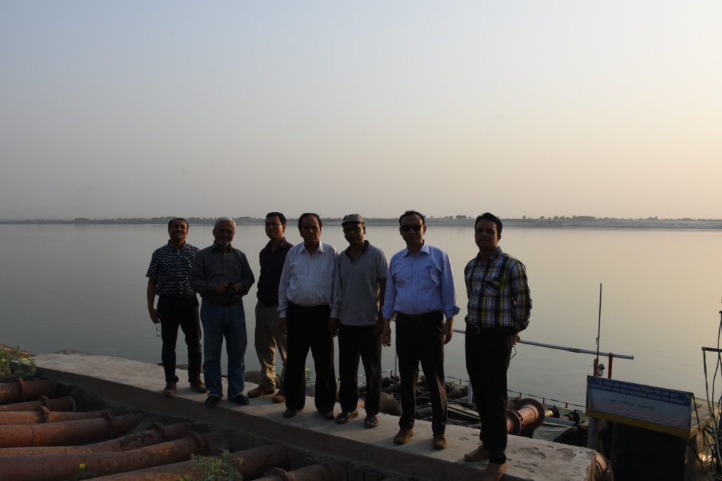
Sharmongla Sech Prokolpo.
technologies_5171 - บังกลาเทศ
ดูส่วนย่อย
ขยายทั้งหมด ย่อทั้งหมด1. ข้อมูลทั่วไป
1.2 รายละเอียดที่ติดต่อได้ของผู้รวบรวมและองค์กรที่เกี่ยวข้องในการประเมินและการจัดเตรียมทำเอกสารของเทคโนโลยี
ผู้เชี่ยวชาญ SLM:
ผู้เชี่ยวชาญ SLM:
ผู้เชี่ยวชาญ SLM:
ชื่อของโครงการซึ่งอำนวยความสะดวกในการทำเอกสารหรือการประเมินเทคโนโลยี (ถ้าเกี่ยวข้อง)
Establishing National Land Use and Land Degradation Profile toward Mainstreaming SLM Practices in Sector Policies (ENALULDEP/SLM)ชื่อขององค์กรซึ่งอำนวยความสะดวกในการทำเอกสารหรือการประเมินเทคโนโลยี (ถ้าเกี่ยวข้อง)
Department of Environment (DoE) - บังกลาเทศ1.3 เงื่อนไขการใช้ข้อมูลที่ได้บันทึกผ่านทาง WOCAT
ผู้รวบรวมและวิทยากรหลักยอมรับเงื่อนไขเกี่ยวกับการใช้ข้อมูลที่ถูกบันทึกผ่านทาง WOCAT:
ใช่
1.4 การเปิดเผยเรื่องความยั่งยืนของเทคโนโลยีที่ได้อธิบายไว้
เทคโนโลยีที่ได้อธิบายไว้นี้เป็นปัญหาของความเสื่อมโทรมโทรมของที่ดินหรือไม่ จึงไม่ได้รับการยอมรับว่าเป็นเทคโนโลยีเพื่อการจัดการที่ดินอย่างยั่งยืน:
ไม่ใช่
2. การอธิบายลักษณะของเทคโนโลยี SLM
2.1 การอธิบายแบบสั้น ๆ ของเทคโนโลยี
คำจำกัดความของเทคโนโลยี:
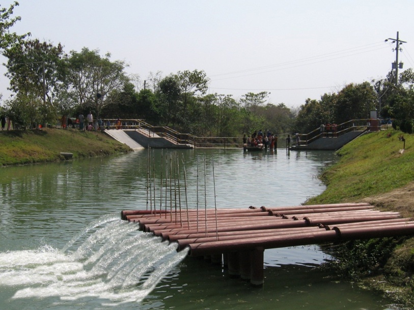
The technology promotes the lifting of river water by pump sets and conveys the water through buried pipelines to a canal. The conserved canal water is used for irrigation delivered by low lift pumps (LLP). Because water is held in the canal it revitalises the ecosystem along its length. Furthermore, using river water for irrigation avoids dangers associated with groundwater depletion.
2.2 การอธิบายแบบละเอียดของเทคโนโลยี
คำอธิบาย:
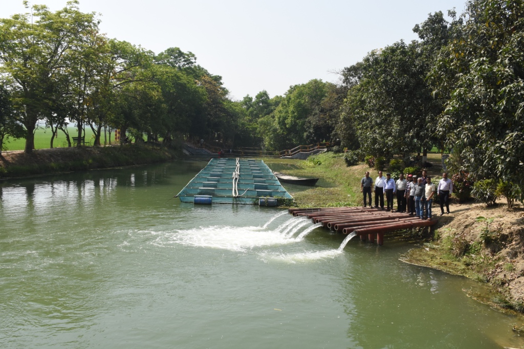
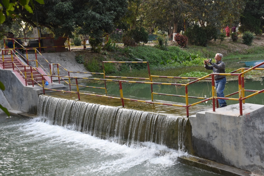
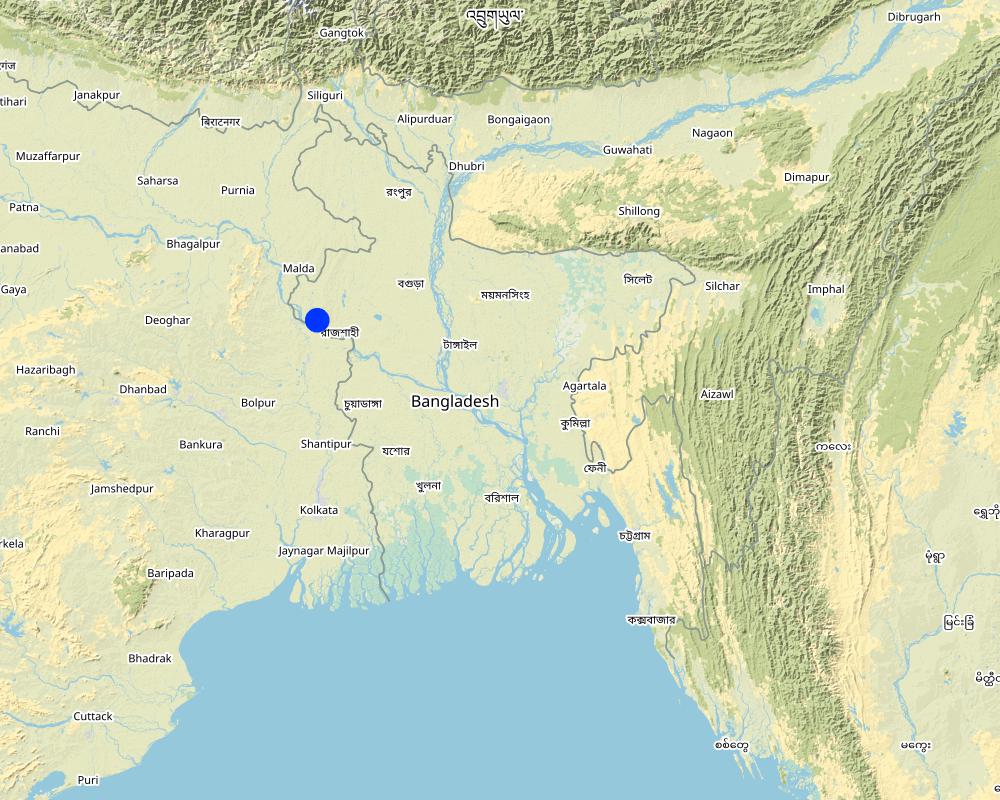
The project is sited at Sharmongla under Godagari Upazilla of Rajshahi district. The Sharmongla canal is located about 3.5 km away from the Padma river. Its total length is 29.0 km. Under this technology, water is lifted from the Padma river by pumps set on a pontoon. The lifted water is then discharged to a canal through underground pipelines. The water so discharged is lifted to the crop fields (delivery points) for irrigation. The elevation difference between the delivery points and the sourcing river is about 21 m. There are numbers of submerged weirs/dams constructed across the canal at different locations for conserving water: the water then helps regenerate the ecosystem along its banks and enriches the habitat.
Pontoon at a glance:
•Year of construction: 2004
•No. of centrifugal pumps at pontoon: 12
•Pump capacity: 50 m lifting height.
•Power of each pump: 60 HP
•Capacity of each pump: 2.5 cusec
•Total capacity of pump sets: 30 cusec
•Capacity of electric sub-station: 750 KW
•No. of discharge pipelines: 12
Sharmongla canal at a glance:
•Length of the canal: 29 km
•Average width of the canal: 15 m
•Average depth from ground level: 5 m
•No. of submerged weirs and dams within the canal: 14
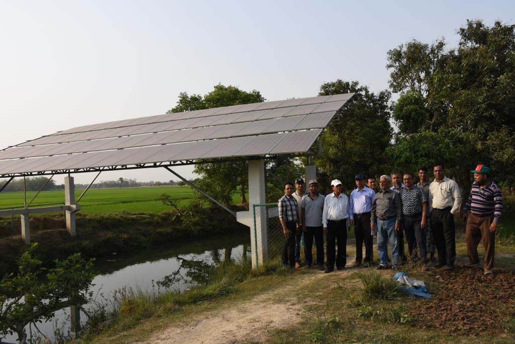
•No. of LLP (low lift pump): 27 electrified and 6 solar pumps
•Total irrigated area: 1850 ha
•Benefiting farmers: 5330
•Harvest yield of rice per year: 20,500 metric tonnes (approx.)
•Afforestation on the canal bank: 65,500 trees
Purposes/objectives of the technology:
•The main purpose of the said technology is to provide water for irrigation. This prevents abstracting of groundwater, which has adverse effects on the environment: therefore this system is environment friendly.
• Enhancing groundwater recharge thereby supports ecosystem function.
•The storing of river water in irrigation canals supports the enrichment of the habitat.
Approach for implementing the technology:
There was no irrigation facility for crop production in this drought-prone area. Government officials came to the locality, discussed with the local community, elites, as well as the farmers. Finally, the local community was convinced about the technology. Then the irrigation system could be implemented in the area. On seeing the success of the technology, the same has been replicated on approx. 9400 ha. in Barind area, benefitting approx. 32,200 farmers.
Maintenance of the technology:
In case of problems, the respective mechanic of that area informs the Assistant Engineer through the Sub-Assistant Engineer. Thus the problem is solved by their own initiative. It is also monitored by the Executive Engineer of the respective District, and finally by the Executive Director from the headquarters if needed.
Crop cultivation:
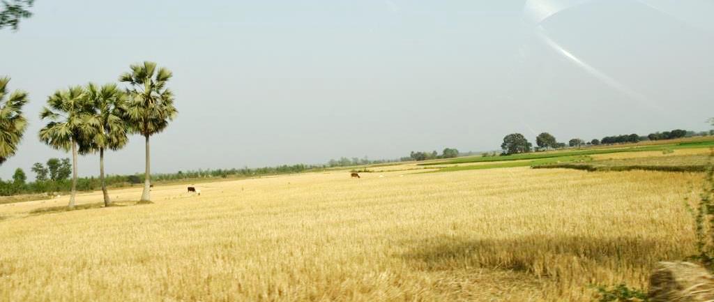
Due to the application of the technology, previously fallow land has come under cultivation/irrigation facilities, mono-cropped land has been converted into multi-cropped land. Different crops, like rice, wheat, maize, mustard, pulses, potato, tomato, spices and other vegetables are cultivated.
Farmers’ acceptance:
The technology has been well accepted by the farmers, as uncultivated land has been brought under cultivation and different crops are now being cultivated year-round.
2.3 รูปภาพของเทคโนโลยี
อัลบั้มสื่อบันทึก
2.4 วีดีโอของเทคโนโลยี
วันที่:
25/03/2019
2.5 ประเทศภูมิภาค หรือสถานที่ตั้งที่เทคโนโลยีได้นำไปใช้และได้รับการครอบคลุมโดยการประเมินนี้
ประเทศ:
บังกลาเทศ
ระบุการกระจายตัวของเทคโนโลยี:
- ใช้ ณ จุดที่เฉพาะเจาะจงหรือเน้นไปยังบริเวณพื้นที่ขนาดเล็ก
Is/are the technology site(s) located in a permanently protected area?
ไม่ใช่
Map
×2.6 วันที่การดำเนินการ
ถ้าไม่รู้ปีที่แน่นอน ให้ระบุวันที่โดยประมาณ:
- 10-50 ปี
2.7 คำแนะนำของเทคโนโลยี
ให้ระบุว่าเทคโนโลยีถูกแนะนำเข้ามาอย่างไร:
- ทางโครงการหรือจากภายนอก
ความคิดเห็น (ประเภทของโครงการ เป็นต้น) :
The following project were providing the irrigation facilities in Barind region:
i) SEMP - Sustainable Environment Mgt. Project
ii) RWCP - Rain Water Conservation Project
iii) EIBA – Extension of Irrigation in Barind area through conservation water in canal
3. การจัดประเภทของเทคโนโลยี SLM
3.1 วัตถุประสงค์หลักของเทคโนโลยี
- ปรับปรุงการผลิตให้ดีขึ้น
- ลด ป้องกัน ฟื้นฟู การเสื่อมโทรมของที่ดิน
- อนุรักษ์ระบบนิเวศน์
- รักษาสภาพหรือปรับปรุงความหลากหลายทางชีวภาพ
- สร้างผลกระทบทางด้านเศรษฐกิจที่เป็นประโยชน์
3.2 ประเภทของการใช้ที่ดินในปัจจุบันที่ได้นำเทคโนโลยีไปใช้
Land use mixed within the same land unit:
ใช่
Specify mixed land use (crops/ grazing/ trees):
- วนเกษตร (Agroforestry)

พื้นที่ปลูกพืช
- การปลูกพืชล้มลุกอายุปีเดียว
- การปลูกไม้ยืนต้น ไม้พุ่ม
- Irrigated rice (Paddy
Tree and shrub cropping - Specify crops:
- mango, mangosteen, guava
จำนวนของฤดูเพาะปลูกต่อปี:
- 3
ระบุ:
Rabi-Pre-Kharif- Kharif
Is intercropping practiced?
ใช่
If yes, specify which crops are intercropped:
Mango with rice,
Is crop rotation practiced?
ใช่
ถ้าใช่ ระบุ:
Major crop rotation is Boro (winter rice) - Transplanted Aman, Minor crop rotations are Potato-Boro- Tasplanted Aman, Rabi crops (mainly vegetables)- Boro- Transplanted Aman
3.3 Has land use changed due to the implementation of the Technology?
Has land use changed due to the implementation of the Technology?
- Yes (Please fill out the questions below with regard to the land use before implementation of the Technology)
Land use mixed within the same land unit:
ใช่
Specify mixed land use (crops/ grazing/ trees):
- วนเกษตร (Agroforestry)
พื้นที่ปลูกพืช
- การปลูกพืชล้มลุกอายุปีเดียว
- การปลูกไม้ยืนต้น ไม้พุ่ม
Is intercropping practiced?
ใช่
If yes, specify which crops are intercropped:
Mango and rice
Is crop rotation practiced?
ไม่ใช่
3.4 การใช้น้ำ
การใช้น้ำของที่ดินที่มีการใช้เทคโนโลยีอยู่:
- น้ำฝนร่วมกับการชลประทาน
3.5 กลุ่ม SLM ที่ตรงกับเทคโนโลยีนี้
- การปลูกป่าร่วมกับพืช
- การจัดการด้านชลประทาน (รวมถึงการลำเลียงส่งน้ำ การระบายน้ำ)
- การจัดการน้ำผิวดิน (น้ำพุ แม่น้ำทะเลสาบ ทะเล)
3.6 มาตรการ SLM ที่ประกอบกันเป็นเทคโนโลยี

มาตรการอนุรักษ์ด้วยโครงสร้าง
- S3: Graded ditches, channels, waterways
- S5: เขื่อน ชั้นดินที่แน่นแข็งบ่อน้ำ
- S7: การกักเก็บน้ำ/การส่งลำเลียง/อุปกรณ์การชลประทาน
- S10: มาตรการในการประหยัดพลังงาน

มาตรการอนุรักษ์ด้วยการจัดการ
- M2: การเปลี่ยนแปลงของการจัดการหรือระดับความเข้มข้น
- M3: การวางผังตามสิ่งแวดล้อมทางธรรมชาติและสิ่งแวดล้อมของมนุษย์
แสดงความคิดเห็น:
There are two stages of harvesting water.
1 - from river water, which is not going directly to the field
2- water reserved in canals and supplied to the field
Para S10 - refers to saving conventional electricity by using solar power for distribution of water to fields
3.7 รูปแบบหลักของการเสื่อมโทรมของที่ดินที่ได้รับการแก้ไขโดยเทคโนโลยี

การเสื่อมโทรมของน้ำ
- Ha (Aridification): การเกิดความแห้งแล้ง
- Hq (Decline of groundwater quality): การลดลงของคุณภาพน้ำบาดาล
แสดงความคิดเห็น:
Barind was driest part of Bangladesh. It was enhanced when groundwater abstraction increased to support cropping by irrigation. The reduction of the groundwater table enhanced the dry out of dug wells, which supported domestic consumption. Hence, aridification was prominent in the area. It is reported that after the application of this technology, there are indications of recharging of the groundwater. Due to the increase in vegetation, the local temperature tends to be cooler than before.
3.8 การป้องกัน การลดลง หรือการฟื้นฟูความเสื่อมโทรมของที่ดิน
ระบุเป้าหมายของเทคโนโลยีกับความเสื่อมโทรมของที่ดิน:
- ป้องกันความเสื่อมโทรมของที่ดิน
- ลดความเสื่อมโทรมของดิน
แสดงความคิดเห็น:
This technology helps reducing land degradation through using river water rather than groundwater for irrigation, thereby
preventing land degradation through increasing the vegetation cover on land.
4. ข้อมูลจำเพาะด้านเทคนิค กิจกรรมการนำไปปฏิบัติใช้ ปัจจัยนำเข้า และค่าใช้จ่าย
4.1 แบบแปลนทางเทคนิคของเทคโนโลยี

ข้อมูลจำเพาะด้านเทคนิค (แบบแปลนทางเทคนิคของเทคโนโลยี):
1. Pontoon: Length 55 ft, Width: 25 ft, Height: 4.50 ft
2. Centrifugal pump (12 nos)—each pump 60 HP,capacity-2.5 cusec, pump head: 50m
3. Electric power station capacity: 750 KW
4. Underground water distribution line (12 nos): Length of each line is 3.50 km
5. Length of water storage canal (Sharmangla canal): 29.0 km (average width 15.0 m and depth 5.0 m)
6. Nos of submerged weir/dam to reserve water in the canal: 14 nos
7. Nos of LLP (electrified) to lift water from the canal to crop field through buried pipeline : 27 nos
8. Nos of solar pump to lift water from the canal to crop field through buried pipeline: 06 nos
9. Nos of Prepaid meter for collecting irrigation charges (Revenue): 33 nos
10. Irrigated area: 1850 ha
11. Construction materials:
-Pontoon: A kind of platform that float on water made of Mild steel sheet, Stainless steel etc.
- Power station: Transformer, electric pole, wire etc.
- Distribution line: mild steel and PVC pipe
- Dam/Submerged weir: steel bar, cement, sand, brick, stone etc.
ผู้เขียน:
Sayed Zillul Bari
วันที่:
25/03/2019
4.2 ข้อมูลทั่วไปเกี่ยวกับการคำนวณปัจจัยนำเข้าและค่าใช้จ่าย
ให้ระบุว่าค่าใช้จ่ายและปัจจัยนำเข้าได้รับการคำนวณอย่างไร:
- ต่อหน่วยเทคโนโลยี
โปรดระบุหน่วย:
1 Pontoon, Pumps, Pipes, weir construction etc
Specify dimensions of unit (if relevant):
Pontoon (Length 55 ft, Width: 25 ft, Height: 4.50 ft) is a platform build on iron sheets, that can float on river, where pumps were set. The pipes for water delivery were of PVC. Water canal in this case compiler referred to canals of Barind which were ephemeral. Now water reserve for year round use.Piping system includes PVC pipe to convey water to the field, where a valve was set to control water disposal. There is a pipe of 12 inch dia to maintain water head through out the system.
อื่นๆ หรือสกุลเงินประจำชาติ (ระบุ):
BDT
If relevant, indicate exchange rate from USD to local currency (e.g. 1 USD = 79.9 Brazilian Real): 1 USD =:
85.0
ระบุค่าเฉลี่ยของค่าจ้างในการจ้างแรงงานต่อวัน:
800 BDT
4.3 กิจกรรมเพื่อการจัดตั้ง
| กิจกรรม | Timing (season) | |
|---|---|---|
| 1. | Pontoon construction and installation on the river | 60 days |
| 2. | Pumps installation on the pontoon | 30 days |
| 3. | Construction of underground water distribution line | 70 days |
| 4. | Re-excavation of derelict canal | 120 days |
| 5. | Construction of submerged weir / dam | 180 days |
| 6. | LLP installation at the canal bank (27 nos) | 150 days |
| 7. | Solar pump installation (06 nos) | 45 days |
| 8. | Pre-paid meter installation at pump sites to collect irrigation charges (33 nos) | 30 days |
| 9. | Buried pipe line construction for irrigation at crop land sites | 120 days |
4.4 ค่าใช้จ่ายของปัจจัยนำเข้าที่จำเป็นสำหรับการจัดตั้ง
| ปัจจัยนำเข้า | หน่วย | ปริมาณ | ค่าใช้จ่ายต่อหน่วย | ค่าใช้จ่ายทั้งหมดต่อปัจจัยนำเข้า | %ของค่าใช้จ่ายที่ก่อให้เกิดขึ้นโดยผู้ใช้ที่ดิน | |
|---|---|---|---|---|---|---|
| วัสดุสำหรับก่อสร้าง | Pontoon construction and installation on the river | 1 | 1.0 | 5000000.0 | 5000000.0 | |
| วัสดุสำหรับก่อสร้าง | Construction of underground water distribution line | 1 | 1.0 | 27800000.0 | 27800000.0 | |
| วัสดุสำหรับก่อสร้าง | Construction of submerged weir / dam | 1 | 14.0 | 1600000.0 | 22400000.0 | |
| วัสดุสำหรับก่อสร้าง | Re-excavation of derelict canal | 1 | 1.0 | 29000000.0 | 29000000.0 | |
| อื่น ๆ | Pre-paid meter installation at pump sites to collect irrigation charges | 1 | 33.0 | 243000.0 | 8019000.0 | |
| อื่น ๆ | Solar pump installation | 1 | 6.0 | 2000000.0 | 12000000.0 | |
| อื่น ๆ | LLP installation at the canal bank (27 nos) | 1 | 8.0 | 2700000.0 | 21600000.0 | |
| อื่น ๆ | Pumps installation on the pontoon | 1 | 12.0 | 1833000.0 | 21996000.0 | |
| อื่น ๆ | Buried pipe line construction for irrigation at crop land sites | 1 | 1.0 | 23100000.0 | 23100000.0 | |
| ค่าใช้จ่ายทั้งหมดของการจัดตั้งเทคโนโลยี | 170915000.0 | |||||
| Total costs for establishment of the Technology in USD | 2010764.71 | |||||
If you are unable to break down the costs in the table above, give an estimation of the total costs of establishing the Technology:
1439.02
ถ้าผู้ใช้ที่ดินรับภาระน้อยกว่า 100% ของค่าใช้จ่าย ให้ระบุว่าใครเป็นผู้รับผิดชอบส่วนที่เหลือ:
none
แสดงความคิดเห็น:
Labor costs etc all included in construction, pipeline installation etc.
4.5 การบำรุงรักษาสภาพหรือกิจกรรมที่เกิดขึ้นเป็นประจำ
| กิจกรรม | ช่วงระยะเวลา/ความถี่ | |
|---|---|---|
| 1. | Pontoon repair and maintenance | 1/5years |
| 2. | Pump repair and maintenance | As per requirement, 1/yr |
| 3. | Distribution line maintenance | As per requirement, 1/yr |
| 4. | Power station repair and maintenance | As per requirement, 1/yr |
| 5. | Submerged weir / dam repair and maintenance | 1/5yrs |
| 6. | LLP repair and maintenance | 2/yr or as and when necessary |
| 7. | Buried pipe line repair and maintenance | 1/6yrs, as and when necessary |
| 8. | Prepaid meter repair | 2-3/yr |
4.6 ค่าใช้จ่ายของปัจจัยนำเข้าและกิจกรรมที่เกิดขึ้นเป็นประจำที่ต้องการการบำรุงรักษา (ต่อปี)
| ปัจจัยนำเข้า | หน่วย | ปริมาณ | ค่าใช้จ่ายต่อหน่วย | ค่าใช้จ่ายทั้งหมดต่อปัจจัยนำเข้า | %ของค่าใช้จ่ายที่ก่อให้เกิดขึ้นโดยผู้ใช้ที่ดิน | |
|---|---|---|---|---|---|---|
| อุปกรณ์ | Prepaid meter repair | 1 | 0.2 | 100000.0 | 20000.0 | |
| วัสดุสำหรับก่อสร้าง | Buried pipe line repair and maintenance | 1 | 1.0 | 0.05 | 0.05 | |
| อื่น ๆ | Pontoon repair and maintenance | 1 | 1.0 | 500000.0 | 500000.0 | |
| อื่น ๆ | Pump repair and maintenance (each) | 1 | 1.0 | 20000.0 | 20000.0 | |
| อื่น ๆ | Distribution line maintenance | 1 | 1.0 | 75000.0 | 75000.0 | |
| อื่น ๆ | Power station repair and maintenance | 1 | 1.0 | 50000.0 | 50000.0 | |
| อื่น ๆ | Submerged weir / dam repair and maintenance (each) | 1 | 1.0 | 200000.0 | 200000.0 | |
| อื่น ๆ | LLP repair and maintenance (each) | 1 | 1.0 | 50000.0 | 50000.0 | |
| ค่าใช้จ่ายทั้งหมดของการบำรุงรักษาสภาพเทคโนโลยี | 915000.05 | |||||
| Total costs for maintenance of the Technology in USD | 10764.71 | |||||
If you are unable to break down the costs in the table above, give an estimation of the total costs of maintaining the Technology:
11.0
ถ้าผู้ใช้ที่ดินรับภาระน้อยกว่า 100% ของค่าใช้จ่าย ให้ระบุว่าใครเป็นผู้รับผิดชอบส่วนที่เหลือ:
Land users share their participation in kinds and allowing installation of pipelines and other infrastructure
แสดงความคิดเห็น:
Land users were trained and they provided land for infrastructures. For example space for outlets and underground pipe installation. Practically they did not contribute any cash.
4.7 ปัจจัยสำคัญที่สุดที่มีผลกระทบต่อค่าใช้จ่าย
ปัจจัยสำคัญที่สุดที่มีผลกระทบต่อค่าใช้จ่ายต่างๆ:
Pontoon construction, power supply and lining of the underground piping system.
5. สิ่งแวดล้อมทางธรรมชาติและของมนุษย์
5.1 ภูมิอากาศ
ฝนประจำปี
- < 250 ม.ม.
- 251-500 ม.ม.
- 501-750 ม.ม.
- 751-1,000 ม.ม.
- 1,001-1,500 ม.ม.
- 1,501-2,000 ม.ม.
- 2,001-3,000 ม.ม.
- 3,001-4,000 ม.ม.
- > 4,000 ม.ม.
ระบุปริมาณน้ำฝนเฉลี่ยรายปี (ถ้ารู้) :หน่วย ม.ม.
1600.00
ข้อมูลจำเพาะ/ความคิดเห็นเรื่องปริมาณน้ำฝน:
Most of the rainfall events happen during May to October
ระบุชื่อของสถานีตรวดวัดอากาศที่ใช้อ้างอิงคือ:
Agroecological region 26
เขตภูมิอากาศเกษตร
- กึ่งชุ่มชื้น
5.2 สภาพภูมิประเทศ
ค่าเฉลี่ยความลาดชัน:
- ราบเรียบ (0-2%)
- ลาดที่ไม่ชัน (3-5%)
- ปานกลาง (6-10%)
- เป็นลูกคลื่น (11-15%)
- เป็นเนิน (16-30%)
- ชัน (31-60%)
- ชันมาก (>60%)
ธรณีสัณฐาน:
- ที่ราบสูง/ที่ราบ
- สันเขา
- ไหล่เขา
- ไหล่เนินเขา
- ตีนเนิน
- หุบเขา
ระดับความสูง:
- 0-100 เมตร
- 101-500 เมตร
- 501-1,000 เมตร
- 1,001-1,500 เมตร
- 1,501-2,000 เมตร
- 2,001-2,500 เมตร
- 2,501-3,000 เมตร
- 3,001-4,000 เมตร
- > 4,000 เมตร
ให้ระบุถ้าเทคโนโลยีได้ถูกนำไปใช้:
- ไม่เกี่ยวข้อง
5.3 ดิน
ค่าเฉลี่ยความลึกของดิน:
- ตื้นมาก (0-20 ซ.ม.)
- ตื้น (21-50 ซ.ม.)
- ลึกปานกลาง (51-80 ซ.ม.)
- ลึก (81-120 ซ.ม.)
- ลึกมาก (>120 ซ.ม.)
เนื้อดิน (ดินชั้นบน):
- ปานกลาง (ดินร่วน ทรายแป้ง)
เนื้อดินล่าง (> 20 ซ.ม.ต่ำจากผิวดิน):
- ละเอียด/หนัก (ดินเหนียว)
อินทรียวัตถุในดิน:
- ต่ำ (<1%)
(ถ้ามี) ให้แนบคำอธิบายเรื่องดินแบบเต็มหรือระบุข้อมูลที่มีอยู่ เช่น ชนิดของดิน ค่า pH ของดินหรือความเป็นกรดของดิน ความสามารถในการแลกเปลี่ยนประจุบวก ไนโตรเจน ความเค็ม เป็นต้น:
High Barind tract, mainly dissected (Closely & Broadly) terrace, soil pH is acidic, low in Nitrogen content, low CEC
5.4 ความเป็นประโยชน์และคุณภาพของน้ำ
ระดับน้ำใต้ดิน:
5-50 เมตร
น้ำไหลบ่าที่ผิวดิน:
ไม่ดีหรือไม่มีเลย
คุณภาพน้ำ (ที่ยังไม่ได้บำบัด):
เป็นน้ำเพื่อการดื่มที่ดี
Water quality refers to:
both ground and surface water
ความเค็มของน้ำเป็นปัญหาหรือไม่:
ไม่ใช่
กำลังเกิดน้ำท่วมในพื้นที่หรือไม่:
ไม่ใช่
ความคิดเห็นและข้อมูลจำเพาะเพิ่มเติมเรื่องคุณภาพและปริมาณน้ำ:
Area is above flood level
5.5 ความหลากหลายทางชีวภาพ
ความหลากหลายทางชนิดพันธุ์:
- ต่ำ
ความหลากหลายของแหล่งที่อยู่:
- ต่ำ
5.6 ลักษณะของผู้ใช้ที่ดินที่นำเทคโนโลยีไปปฏิบัติใช้
อยู่กับที่หรือเร่ร่อน:
- อยู่กับที่
แนวทางการตลาดของระบบการผลิต:
- mixed (subsistence/ commercial)
รายได้ที่มาจากนอกฟาร์ม:
- 10-50% ของรายได้ทั้งหมด
ระดับของความมั่งคั่งโดยเปรียบเทียบ:
- พอมีพอกิน
เป็นรายบุคคล/ครัวเรือน:
- เป็นรายบุคคล/ครัวเรือน
ระดับของการใช้เครื่องจักรกล:
- งานที่ใช้แรงกาย
- การใช้เครื่องจักรหรือเครื่องยนต์
เพศ:
- หญิง
- ชาย
อายุของผู้ใช้ที่ดิน:
- ผู้เยาว์
- วัยกลางคน
- ผู้สูงอายุ
5.7 Average area of land used by land users applying the Technology
- < 0.5 เฮกตาร์
- 0.5-1 เฮกตาร์
- 1-2 เฮกตาร์
- 2-5 เฮกตาร์
- 5-15 เฮกตาร์
- 15-50 เฮกตาร์
- 50-100 เฮกตาร์
- 100-500 เฮกตาร์
- 500-1,000 เฮกตาร์
- 1,000-10,000 เฮกตาร์
- >10,000 เฮกตาร์
พิจารณาว่าเป็นขนาดเล็ก กลาง หรือขนาดใหญ่ (ซึ่งอ้างอิงถึงบริบทระดับท้องถิ่น):
- ขนาดใหญ่
แสดงความคิดเห็น:
Yes. The farmers of Barind are of wide range. The large farmers are basically absentee. Medium range farmers engage themselves in their land and in addition they rent land from large farmers. So there is complex ownership.
This was from field feedback.
5.8 กรรมสิทธิ์ในที่ดิน สิทธิในการใช้ที่ดินและสิทธิในการใช้น้ำ
กรรมสิทธิ์ในที่ดิน:
- รายบุคคล ได้รับสิทธิครอบครอง
สิทธิในการใช้ที่ดิน:
- เช่า
- รายบุคคล
สิทธิในการใช้น้ำ:
- เข้าถึงได้แบบเปิด (ไม่ได้จัดระเบียบ)
- เช่า
Are land use rights based on a traditional legal system?
ใช่
5.9 การเข้าถึงบริการและโครงสร้างพื้นฐาน
สุขภาพ:
- จน
- ปานกลาง
- ดี
การศึกษา:
- จน
- ปานกลาง
- ดี
ความช่วยเหลือทางด้านเทคนิค:
- จน
- ปานกลาง
- ดี
การจ้างงาน (เช่น ภายนอกฟาร์ม):
- จน
- ปานกลาง
- ดี
ตลาด:
- จน
- ปานกลาง
- ดี
พลังงาน:
- จน
- ปานกลาง
- ดี
ถนนและการขนส่ง:
- จน
- ปานกลาง
- ดี
น้ำดื่มและการสุขาภิบาล:
- จน
- ปานกลาง
- ดี
บริการด้านการเงิน:
- จน
- ปานกลาง
- ดี
6. ผลกระทบและสรุปคำบอกกล่าว
6.1 ผลกระทบในพื้นที่ดำเนินการ (On-site) จากการใช้เทคโนโลยี
ผลกระทบทางด้านเศรษฐกิจและสังคม
การผลิต
การผลิตพืชผล
คุณภาพพืชผล
การผลิตพืชที่ใช้เลี้ยงปศุสัตว์
คุณภาพพืชที่ใช้เลี้ยงปศุสัตว์
การผลิตสัตว์
การเสี่ยงต่อความล้มเหลวในการผลิต
ความหลากหลายของผลิตภัณฑ์
พื้นที่สำหรับการผลิต
การจัดการที่ดิน
ความเป็นประโยชน์และคุณภาพของน้ำ
การมีน้ำดื่มไว้ให้ใช้
คุณภาพน้ำดื่ม
การมีน้ำไว้ให้ปศุสัตว์
คุณภาพน้ำสำหรับปศุสัตว์
การมีน้ำไว้ให้สำหรับการชลประทาน
คุณภาพน้ำสำหรับการชลประทาน
ความต้องการน้ำจากการชลประทาน
แสดงความคิดเห็น/ระบุ:
At present land users are used to grow high water demanding crops. For example Boro paddy and potato both crops require large volume of water and the irrigated area slowly increasing, that situation demand of irrigation water increasing.
รายได้และค่าใช้จ่าย
ค่าใช่จ่ายของปัจจัยการผลิตทางการเกษตร
แสดงความคิดเห็น/ระบุ:
The supply of agricultural inputs increased and channelized through deploying dealers etc. Hence expenses relatively decreased
รายได้จากฟาร์ม
ความหลากหลายของแหล่งผลิตรายได้
ความเหลื่อมล้ำทางเศรษฐกิจ
แสดงความคิดเห็น/ระบุ:
Basically in this area could be grouped in to two. One group has almost no land and previously they have to migrate beyond barind area as labor and they were poor. At present they have job (agri-labor or otherwise) in their area and become more solvent then past 90's. On other hand the second group cultivate the land of their own or leased, which they could not in 90's. They also in handicap because of poor crop and no option to cultivate in two seasons. Hence apparently both groups as of their status are in well shape. The peoples those who have no land for cultivation now can engage them in many other entrepreneurship (e.g. farm product marketing, livestock/poultry raring, carpentering, grocery, etc etc) emerged.
ภาระงาน
ผลกระทบด้านสังคมวัฒนธรรมอื่น ๆ
ความมั่นคงด้านอาหาร / พึ่งตนเองได้
สถานการณ์ด้านสุขภาพ
การใช้ที่ดิน / สิทธิในการใช้น้ำ
โอกาสทางวัฒนธรรม
โอกาสทางด้านสันทนาการ
สถาบันของชุมชน
สถาบันแห่งชาติ
แสดงความคิดเห็น/ระบุ:
Along with the Barind Multipurpose Development Authority (BMDA) other national institutions like Department of Agricultural Extension, Livestock, Fisheries, Bangladesh Rural Development Board (BRDB), Financial institutions- Rajshahi Agricultural Development Bank and others (NGO) are operating more effectively in the Barind in multiple dimensions. In addition students from Rajshahi University also engaged in their research on various issues. BMDA also improving its capacity and skill to develop more effective approach for Barind area.
SLM หรือความรู้เรื่องความเสื่อมโทรมของที่ดิน
การบรรเทาความขัดแย้ง
ผลกระทบด้านนิเวศวิทยา
วัฐจักรน้ำหรือน้ำบ่า
ปริมาณน้ำ
คุณภาพน้ำ
การเก็บเกี่ยวหรือการกักเก็บน้ำ
น้ำไหลบ่าที่ผิวดิน
แสดงความคิดเห็น/ระบุ:
This comment was done comparing between conveying water by open drainage and through pipeline. Definitely there are almost no run-off from pipe line distribution. On the hand land users have to confirm their field bunds to protect run-off. Prepaid metering system also restricted land users not to allow excess water to over flow from their field. In-spite of that there may be small amount run-off, but the detachment of top soils is within tolerable limit and accumulate within field bunds.
การระบายน้ำส่วนเกิน
น้ำบาดาลหรือระดับน้ำในแอ่งน้ำบาดาล
แสดงความคิดเห็น/ระบุ:
It is reported that ground water slowly recharged, As a results shallow tube wells are also working , which were about to abandoned before.
การระเหย
แสดงความคิดเห็น/ระบุ:
Vegetation coverage increased,
ดิน
สิ่งปกคลุมดิน
แสดงความคิดเห็น/ระบุ:
Increased land cover-Reduced drought
การสูญเสียดิน
แสดงความคิดเห็น/ระบุ:
In 90's the lands were bare and in monsoon after heavy downpour a large amount of water going to downstream as run-off with detached top soil. At present land is covered, field bunds are strengthen, restrict run-off as a result soil loss decreased.
การสะสมของดิน
แสดงความคิดเห็น/ระบุ:
Field bunds enhance soil accumulation by limiting run-off water by field bunds/dykes.
การอัดแน่นของดิน
แสดงความคิดเห็น/ระบุ:
Mechanized cultivation and usage of farm machinery however enhance soil compaction.
ลดความเสี่ยงของภัยพิบัติ
ผลกระทบจากน้ำท่วม
แสดงความคิดเห็น/ระบุ:
The area is above flood level
ผลกระทบจากภัยแล้ง
การปล่อยคาร์บอนและก๊าซเรือนกระจก
แสดงความคิดเห็น/ระบุ:
Emission of carbon decreased as vegetation cover round the year increased.
ภูมิอากาศจุลภาค
แสดงความคิดเห็น/ระบุ:
Reduced dusty wind, temperature cooler then before.
ผลกระทบด้านนิเวศวิทยาอื่น ๆ
The Barind was almost desert like before 90's. Its natural vegetation were almost extinct. Biodiversity both Species and habitat were low. At present it is improving spectacularly.
Specify assessment of on-site impacts (measurements):
In all a desert like Barind tract become green now.
6.2 ผลกระทบนอกพื้นที่ดำเนินการ (Off-site) จากการใช้เทคโนโลยี
น้ำที่ใช้ประโยชน์ได้
แสดงความคิดเห็น/ระบุ:
Usage of surface water reduces groundwater abstraction and improves groundwater (GW) recharge
การเกิดมลพิษในน้ำบาดาลหรือแม่น้ำ
แสดงความคิดเห็น/ระบุ:
As the land cover has increased, that has a substantial impact on limiting polluted surface water to flow up to river.
6.3 การเผชิญและความตอบสนองของเทคโนโลยีต่อการเปลี่ยนแปลงสภาพภูมิอากาศที่ค่อยเป็นค่อยไป และสภาพรุนแรงของภูมิอากาศ / ภัยพิบัติ (ที่รับรู้ได้โดยผู้ใช้ที่ดิน)
การเปลี่ยนแปลงสภาพภูมิอากาศที่ค่อยเป็นค่อยไป
การเปลี่ยนแปลงสภาพภูมิอากาศที่ค่อยเป็นค่อยไป
| ฤดู | increase or decrease | เทคโนโลยีมีวิธีการรับมืออย่างไร | |
|---|---|---|---|
| อุณหภูมิประจำปี | ลดลง | ดีมาก | |
| อุณหภูมิตามฤดูกาล | ฤดูร้อน | ลดลง | ดีมาก |
| ฝนประจำปี | เพิ่มขึ้น | ดี | |
| ฝนตามฤดู | ฤดูร้อน | เพิ่มขึ้น | ไม่ทราบ |
6.4 การวิเคราะห์ค่าใช้จ่ายและผลประโยชน์ที่ได้รับ
ผลประโยชน์ที่ได้รับเปรียบเทียบกับค่าใช้จ่ายในการจัดตั้งเป็นอย่างไร (จากมุมมองของผู้ใช้ที่ดิน)
ผลตอบแทนระยะสั้น:
ด้านลบเล็กน้อย
ผลตอบแทนระยะยาว:
ด้านบวกอย่างมาก
ผลประโยชน์ที่ได้รับเปรียบเทียบกับค่าใช้จ่ายในการบำรุงรักษาหรือต้นทุนที่เกิดขึ้นซ้ำอีก เป็นอย่างไร (จากมุมมองของผู้ใช้ที่ดิน)
ผลตอบแทนระยะสั้น:
ด้านลบ
ผลตอบแทนระยะยาว:
ด้านบวก
6.5 การปรับตัวของเทคโนโลยี
- > 50%
ถ้ามีข้อมูลให้บอกปริมาณด้วย (จำนวนของครัวเรือนหรือครอบคลุมพื้นที่):
It could rather to explain as the beneficiaries of the technology. Truly a single land user or a group of land user will not able to install this type of system for multiple reasons. There are two components of this technology, one is the government institution who provided the scope of using surface water for irrigation and the second one are the land user who use the scope or facilities of irrigation system Here about 1800 farmers are involved to use surface water as their irrigation source.
Of all those who have adopted the Technology, how many did so spontaneously, i.e. without receiving any material incentives/ payments?
- 91-100%
แสดงความคิดเห็น:
Most of the farmers of the area who has land adopted surface water for irrigation instead of ground water abstraction.
6.6 การปรับตัว
เทคโนโลยีได้รับการปรับเปลี่ยนเมื่อเร็วๆนี้ เพื่อให้ปรับตัวเข้ากับสภาพที่กำลังเปลี่ยนแปลงหรือไม่:
ใช่
ถ้าตอบว่าใช่ ให้ระบุว่าเงื่อนไขการเปลี่ยนแปลงใดที่ถูกปรับตัว:
- การมีแรงงานไว้ให้ใช้ (เนื่องจากการอพยพย้ายถิ่นฐาน)
ให้ระบุการปรับตัวของเทคโนโลยี (การออกแบบ วัสดุหรือชนิดพันธุ์ เป็นต้น):
where there are no canal for water storage , local ponds are used to reserve the surface water to irrigate land surrounding the pods and obviously where river water could not be reached.
6.7 จุดแข็ง / ข้อได้เปรียบ / โอกาสของเทคโนโลยี
| จุดแข็ง / ข้อได้เปรียบ / โอกาสในทัศนคติของผู้ใช้ที่ดิน |
|---|
| Ensured crop production through irrigation |
| Reduced ground water irrigation and decrease ground water depletion. |
| Increased work facility at project area |
| จุดแข็ง / ข้อได้เปรียบ / โอกาสในทัศนคติของผู้รวบรวมหรือวิทยากรหลัก |
|---|
| Improved socio-economic condition of beneficiaries |
| Increased ground water recharge |
| Increased fish cultivation and duck farming at the canal |
6.8 จุดอ่อน / ข้อเสียเปรียบ / ความเสี่ยงของเทคโนโลยีและวิธีการแก้ไข
| จุดอ่อน / ข้อเสียเปรียบ / ความเสี่ยงในทัศนคติของผู้ใช้ที่ดิน | มีวิธีการแก้ไขได้อย่างไร |
|---|---|
| Scope of individual level implementation is very limited | Community approach will facilitate the SLM implementation etc. |
| Maintenance, distribution and regulation of water etc have no control of the beneficiaries | Capacity of the beneficiaries to be developed |
| จุดอ่อน / ข้อเสียเปรียบ / ความเสี่ยงในทัศนคติของผู้รวบรวมหรือวิทยากรหลัก | มีวิธีการแก้ไขได้อย่างไร |
|---|---|
| Source of lifting water points may be shifted in the long run | Efficiencies of irrigation water supply need more attention with demand and supply. |
| Weak linkage with beneficiaries | Integrated approach needed to include community and implementing agencies. |
| Crops with high water demand may not sustain in the long run | Appropriate crop and cropping patterns are to be adopted with crop zoning |
| Increasing cropping intensity leads to deficiency of soil nutrients | Monitoring of soil health essential for this region. |
7. การอ้างอิงและการเชื่อมต่อ
7.1 วิธีการและแหล่งข้อมูล
- ไปเยี่ยมชมภาคสนาม การสำรวจพื้นที่ภาคสนาม
Three times with experts of this area
- การสัมภาษณ์กับผู้ใช้ที่ดิน
20
- การสัมภาษณ์ผู้เชี่ยวชาญด้าน SLM หรือผู้ชำนาญ
10
- การเก็บรวบรวมมาจากรายงานและเอกสารที่มีอยู่
Consulted relevant project documents
วันที่เก็บรวบรวมข้อมูล(ภาคสนาม) :
25/03/2019
แสดงความคิดเห็น:
A long process was maintained from building capacity of the professionals to handle WOCAT tools, initial inventory with core experts and screening with local professionals, documentation in field and compiling data in the WOCAT format, which was again validated with large local groups of scientists, extension officials, local government, NGO, lead farmers etc.
7.2 การอ้างอิงถึงสิ่งตีพิมพ์
หัวข้อ, ผู้เขียน, ปี, หมายเลข ISBN:
Project documents
ชื่อเรื่อง ผู้เขียน ปี ISBN:
Available in BMDA
7.3 Links to relevant online information
ชื่อเรื่องหรือคำอธิบาย:
Questionnaires on Tecnologies (QT)
URL:
www.wocat.net
ชื่อเรื่องหรือคำอธิบาย:
Sustainable land management (SLM)
URL:
https://knowledge.unccd.int/topics/sustainable-land-management-slm
ชื่อเรื่องหรือคำอธิบาย:
Achieving Land Degradation Neutrality at the country level
URL:
https://knowledge.unccd.int/topics/land-degradation-neutrality
7.4 General comments
Excellent
ลิงก์และโมดูล
ขยายทั้งหมด ย่อทั้งหมดลิงก์
ไม่มีลิงก์
โมดูล
ไม่มีโมดูล