Soil and Water Conservation Channels [ยูกันดา]
- ผู้สร้างสรรค์:
- การอัพเดท:
- ผู้รวบรวม: Philip Tibenderana
- ผู้เรียบเรียง: Mirjam Nufer
- ผู้ตรวจสอบ: Alexandra Gavilano, Hanspeter Liniger, Nicole Harari
Emirongooti
technologies_711 - ยูกันดา
ดูส่วนย่อย
ขยายทั้งหมด ย่อทั้งหมด1. ข้อมูลทั่วไป
1.2 รายละเอียดที่ติดต่อได้ของผู้รวบรวมและองค์กรที่เกี่ยวข้องในการประเมินและการจัดเตรียมทำเอกสารของเทคโนโลยี
วิทยากรหลัก
ผู้เชี่ยวชาญ SLM:
ชื่อของโครงการซึ่งอำนวยความสะดวกในการทำเอกสารหรือการประเมินเทคโนโลยี (ถ้าเกี่ยวข้อง)
Book project: where people and their land are safer - A Compendium of Good Practices in Disaster Risk Reduction (DRR) (where people and their land are safer)ชื่อขององค์กรซึ่งอำนวยความสะดวกในการทำเอกสารหรือการประเมินเทคโนโลยี (ถ้าเกี่ยวข้อง)
Tear Fund Switzerland (Tear Fund Switzerland) - สวิตเซอร์แลนด์1.3 เงื่อนไขการใช้ข้อมูลที่ได้บันทึกผ่านทาง WOCAT
ผู้รวบรวมและวิทยากรหลักยอมรับเงื่อนไขเกี่ยวกับการใช้ข้อมูลที่ถูกบันทึกผ่านทาง WOCAT:
ใช่
1.4 การเปิดเผยเรื่องความยั่งยืนของเทคโนโลยีที่ได้อธิบายไว้
เทคโนโลยีที่ได้อธิบายไว้นี้เป็นปัญหาของความเสื่อมโทรมโทรมของที่ดินหรือไม่ จึงไม่ได้รับการยอมรับว่าเป็นเทคโนโลยีเพื่อการจัดการที่ดินอย่างยั่งยืน:
ไม่ใช่
แสดงความคิดเห็น:
So far, where this technology has been applied, the water runoff has been reduced, water retention increased and soils trapped
1.5 Reference to Questionnaire(s) on SLM Approaches (documented using WOCAT)
Catchment Based Integrated Water Resources Management [ยูกันดา]
Catchment based integrated water resources management is a process which promotes the coordinated development and management of water, land and related resources in order to maximise economic and social welfare in an equitable manner without compromising the sustainability of vital eco systems
- ผู้รวบรวม: Philip Tibenderana
2. การอธิบายลักษณะของเทคโนโลยี SLM
2.1 การอธิบายแบบสั้น ๆ ของเทคโนโลยี
คำจำกัดความของเทคโนโลยี:
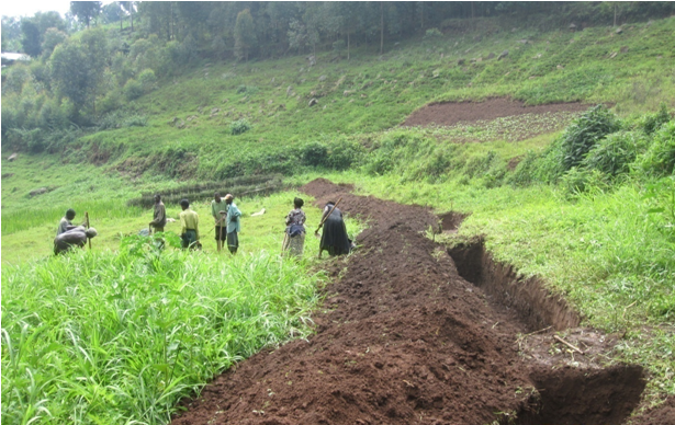
A soil and water conservation channel is an excavated trench along the contour with tie bands after an interval to trap water and soil which are being washed down the slopes by a downpour
2.2 การอธิบายแบบละเอียดของเทคโนโลยี
คำอธิบาย:
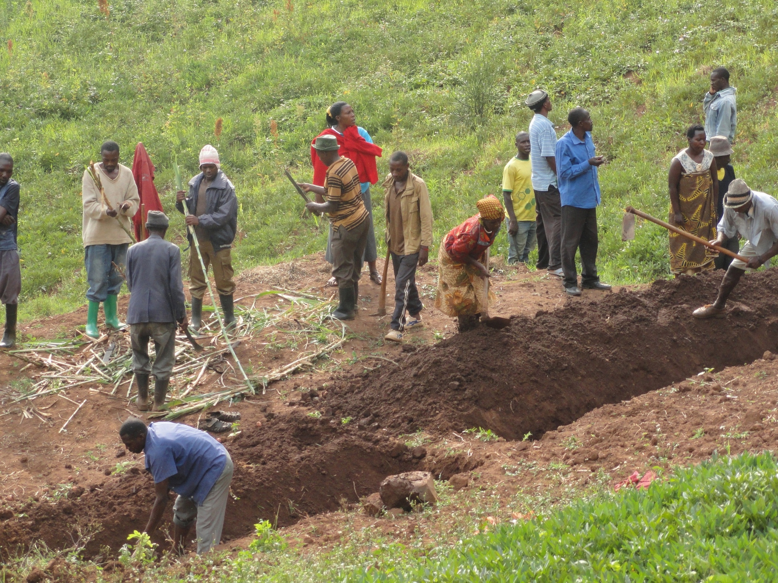
The technology is applied in already existing degraded farmlands, which are individually owned. An average farm size is less than half an acre.
A typical soil and water conservation channel is a trench 1m wide, 1m deep and with tie bands (1m wide to avoid flow of water along the trench) at intervals of 10m along the contour. The excavated soil is used piled up into an earth bund next to the trench at lower side and stabilized by planting hedge rows of "Starria grass" to avoid erosion.
This technology reduces the speed of water running down the slope during a downpour and traps the water and soil that is being washed thereby reducing soil erosion and increasing water retention.
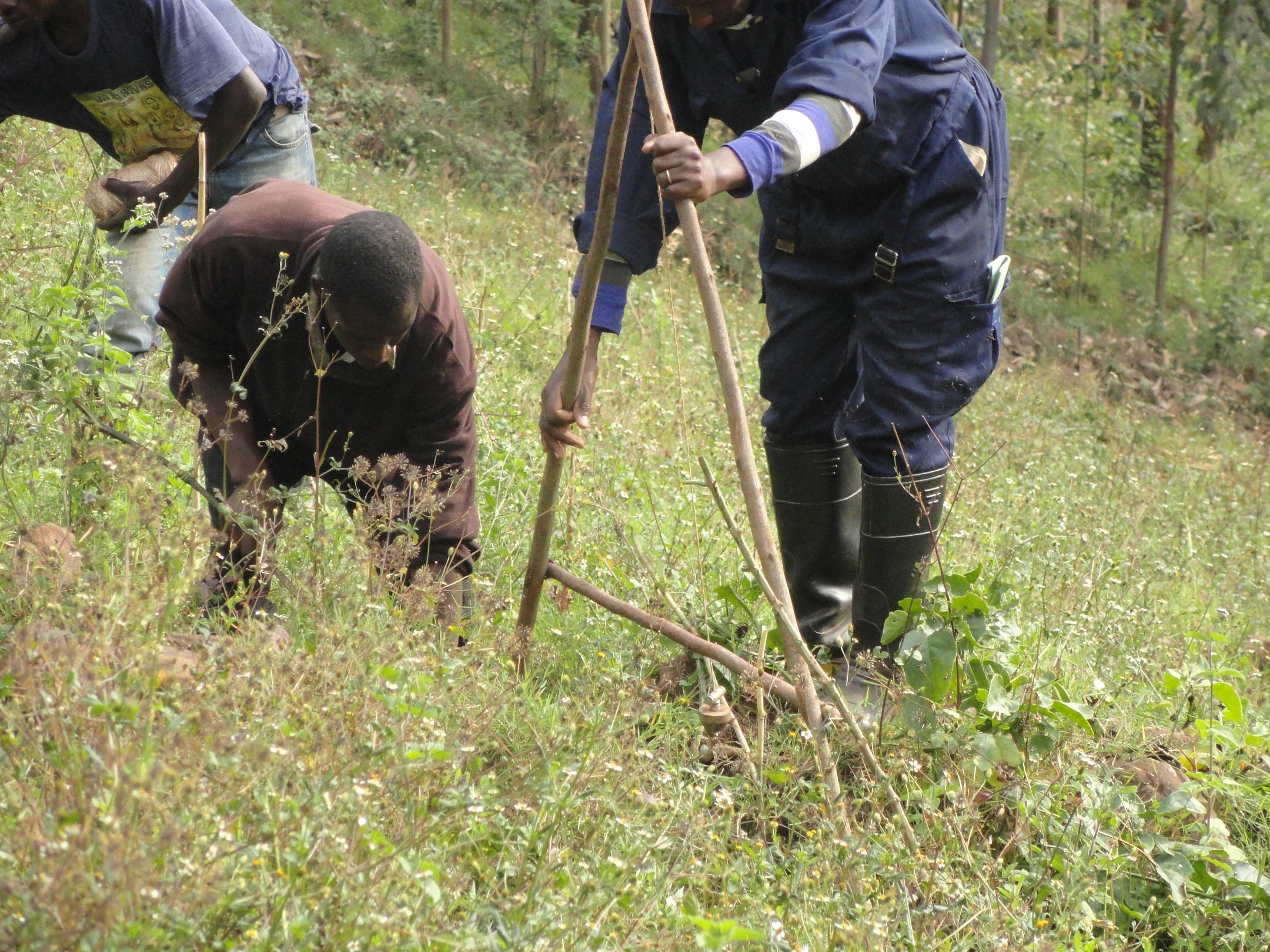
Areas which are prone to degradation by erosion are identified and later, the farmers are trained on benefits of this technology, how to set out the technology by use of the ‘A – frame’, how to construct the channels and how to maintain them by periodic de-silting and planting grasses and shrubs on the bands.
The 'A - Frame' is an A shaped structure made from wooden poles or thin metal poles that can be easily constructed and used to peg flat or graded contours or water drains.
This technology helps maintain the good top soil, which would have otherwise been washed down the slope into the valley and increases water retention.
The land users like this technology because their soil is not lost but what they dislike about this technology is that it is labour intensive, setting it out is technical and not easily conceptualized and it takes part of the land. Individual land users excavate these channels in their individual plots of land using simple hand tools like hoes, spades and pick axes.
2.3 รูปภาพของเทคโนโลยี
อัลบั้มสื่อบันทึก
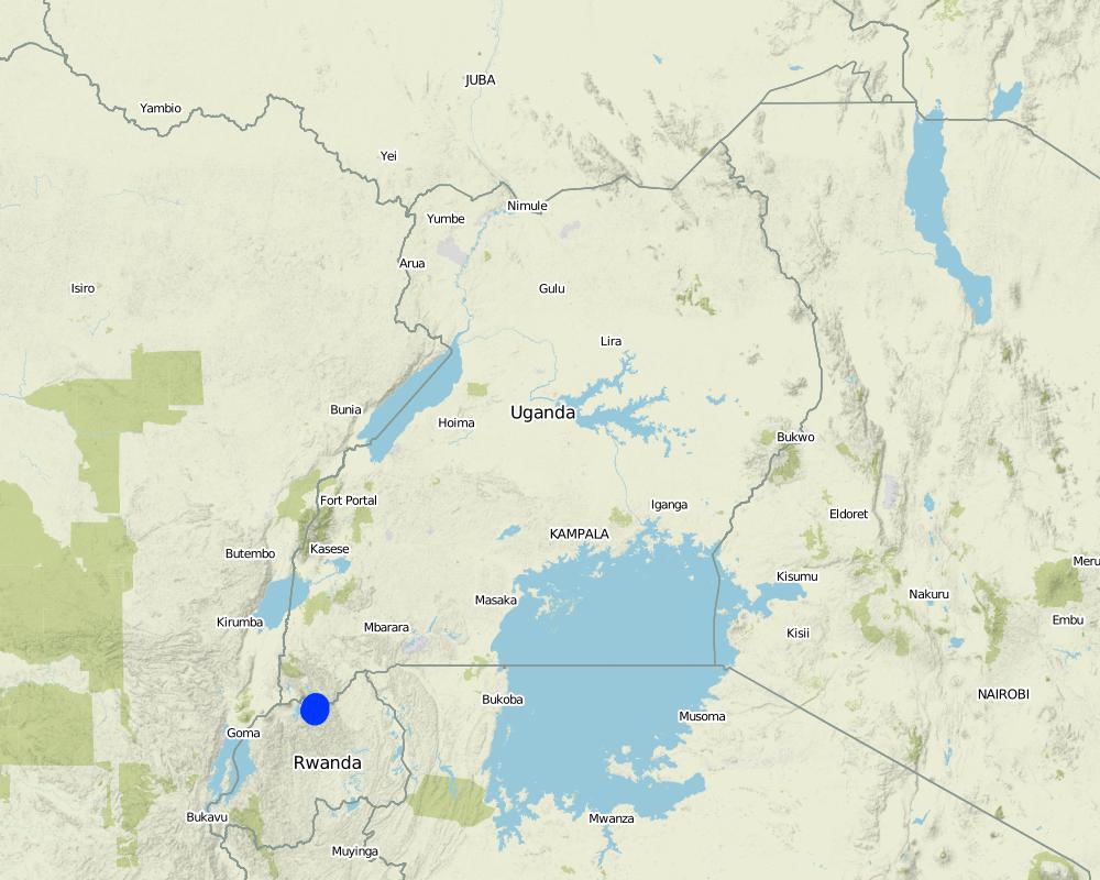
2.5 ประเทศภูมิภาค หรือสถานที่ตั้งที่เทคโนโลยีได้นำไปใช้และได้รับการครอบคลุมโดยการประเมินนี้
ประเทศ:
ยูกันดา
ภูมิภาค/รัฐ/จังหวัด:
South Western Region
ข้อมูลจำเพาะเพิ่มเติมของสถานที่ตั้ง :
Rubaya Sub County, Kabale District
ระบุการกระจายตัวของเทคโนโลยี:
- กระจายไปอย่างสม่ำเสมอในพื้นที่
แสดงความคิดเห็น:
rotational systems (crop rotation, fallows, shifting cultivation)
improved ground/ vegetation cover
integrated soil fertility management
Map
×2.6 วันที่การดำเนินการ
ระบุปีที่ใช้:
2015
2.7 คำแนะนำของเทคโนโลยี
ให้ระบุว่าเทคโนโลยีถูกแนะนำเข้ามาอย่างไร:
- ทางโครงการหรือจากภายนอก
ความคิดเห็น (ประเภทของโครงการ เป็นต้น) :
The technology was introduced under the Integrated Water Resources Management Project to support farmers to mazimise land productivity
3. การจัดประเภทของเทคโนโลยี SLM
3.1 วัตถุประสงค์หลักของเทคโนโลยี
- ปรับปรุงการผลิตให้ดีขึ้น
- ลด ป้องกัน ฟื้นฟู การเสื่อมโทรมของที่ดิน
- อนุรักษ์ระบบนิเวศน์
- ป้องกันพื้นที่ลุ่มน้ำ/บริเวณท้ายน้ำ โดยร่วมกับเทคโนโลยีอื่นๆ
- ลดความเสี่ยงของภัยพิบัติ
- ปรับตัวเข้ากับการเปลี่ยนแปลงภูมิอากาศของโลก สภาพภูมิอากาศที่รุนแรงและผลกระทบ
- ชะลอการเปลี่ยนแปลงภูมิอากาศของโลกและผลกระทบ
- สร้างผลกระทบทางด้านเศรษฐกิจที่เป็นประโยชน์
- สร้างผลกระทบทางด้านสังคมที่เป็นประโยชน์
3.2 ประเภทของการใช้ที่ดินในปัจจุบันที่ได้นำเทคโนโลยีไปใช้

พื้นที่ปลูกพืช
- การปลูกพืชล้มลุกอายุปีเดียว
- การปลูกพืชยืนต้นที่ไม่มีเนื้อไม้
จำนวนของฤดูเพาะปลูกต่อปี:
- 2
ระบุ:
September to January and March to June
3.4 การใช้น้ำ
การใช้น้ำของที่ดินที่มีการใช้เทคโนโลยีอยู่:
- จากน้ำฝน
3.5 กลุ่ม SLM ที่ตรงกับเทคโนโลยีนี้
- ระบบหมุนเวียน (การปลูกพืชหมุนเวียน การพักดิน การเกษตรแบบไร่เลื่อนลอย)
- การปรับปรุงดิน / พืชคลุมดิน
- การจัดการความอุดมสมบรูณ์ของดินแบบผสมผสาน
3.6 มาตรการ SLM ที่ประกอบกันเป็นเทคโนโลยี

มาตรการอนุรักษ์ด้วยวิธีพืช
- V1: ต้นไม้และพุ่มไม้คลุมดิน
- V2: หญ้าและไม้ยืนต้น

มาตรการอนุรักษ์ด้วยโครงสร้าง
- S3: Graded ditches, channels, waterways
3.7 รูปแบบหลักของการเสื่อมโทรมของที่ดินที่ได้รับการแก้ไขโดยเทคโนโลยี

การกัดกร่อนของดินโดยน้ำ
- Wt (Loss of topsoil): การสูญเสียดินชั้นบนหรือการกัดกร่อนที่ผิวดิน
- Wg (Gully erosion): การกัดกร่อนแบบร่องธารหรือการทำให้เกิดร่องน้ำเซาะ
- Wm (Mass movement): การเคลื่อนตัวของมวลดินหรือดินถล่ม
3.8 การป้องกัน การลดลง หรือการฟื้นฟูความเสื่อมโทรมของที่ดิน
ระบุเป้าหมายของเทคโนโลยีกับความเสื่อมโทรมของที่ดิน:
- ลดความเสื่อมโทรมของดิน
4. ข้อมูลจำเพาะด้านเทคนิค กิจกรรมการนำไปปฏิบัติใช้ ปัจจัยนำเข้า และค่าใช้จ่าย
4.1 แบบแปลนทางเทคนิคของเทคโนโลยี
ผู้เขียน:
Kigezi Diocese Water and Sanitation Programme
วันที่:
12/12/2016
ผู้เขียน:
Kigezi Diocese Water and Sanitation Programme
วันที่:
12/12/2016
ผู้เขียน:
Kigezi Diocese Water and Sanitation Programme
วันที่:
12/12/2016
4.2 ข้อมูลทั่วไปเกี่ยวกับการคำนวณปัจจัยนำเข้าและค่าใช้จ่าย
ให้ระบุว่าค่าใช้จ่ายและปัจจัยนำเข้าได้รับการคำนวณอย่างไร:
- ต่อหน่วยเทคโนโลยี
โปรดระบุหน่วย:
Per acre (each acre usually has 150meters of channels)
ระบุสกุลเงินที่ใช้คำนวณค่าใช้จ่าย:
- USD
If relevant, indicate exchange rate from USD to local currency (e.g. 1 USD = 79.9 Brazilian Real): 1 USD =:
3300.0
ระบุค่าเฉลี่ยของค่าจ้างในการจ้างแรงงานต่อวัน:
USD 2.12
4.3 กิจกรรมเพื่อการจัดตั้ง
| กิจกรรม | Timing (season) | |
|---|---|---|
| 1. | Setting out the soil and water conservation channel using the A-frame to set out the contour lines | After harvest of crops |
| 2. | Excavation of the soil and water conservation channel and build up soil bund on the lower side of the trench; leave a tie band every 10 meters | In the dry season |
| 3. | Planting of hedge rows on the bands | On the onset of rains |
4.4 ค่าใช้จ่ายของปัจจัยนำเข้าที่จำเป็นสำหรับการจัดตั้ง
| ปัจจัยนำเข้า | หน่วย | ปริมาณ | ค่าใช้จ่ายต่อหน่วย | ค่าใช้จ่ายทั้งหมดต่อปัจจัยนำเข้า | %ของค่าใช้จ่ายที่ก่อให้เกิดขึ้นโดยผู้ใช้ที่ดิน | |
|---|---|---|---|---|---|---|
| แรงงาน | Setting out | meter | 150.0 | 0.02 | 3.0 | 100.0 |
| แรงงาน | Excavation of the channels | meter | 150.0 | 1.06 | 159.0 | 100.0 |
| แรงงาน | Planting starria grass | meter | 150.0 | 0.02 | 3.0 | 100.0 |
| อุปกรณ์ | Forked hoes (1 piece can excavate 1km) | meter | 6.67 | 5.0 | 33.35 | |
| อุปกรณ์ | Pick axes (1 piece can excavate 1km) | meter | 6.67 | 5.0 | 33.35 | |
| อุปกรณ์ | Spades (1 piece can be used on 1km) | meter | 6.67 | 5.0 | 33.35 | |
| วัสดุด้านพืช | Starria grass (1 sack for 20m) | sacks | 7.5 | 7.0 | 52.5 | |
| ค่าใช้จ่ายทั้งหมดของการจัดตั้งเทคโนโลยี | 317.55 | |||||
| Total costs for establishment of the Technology in USD | 0.1 | |||||
ถ้าผู้ใช้ที่ดินรับภาระน้อยกว่า 100% ของค่าใช้จ่าย ให้ระบุว่าใครเป็นผู้รับผิดชอบส่วนที่เหลือ:
Kigezi Diocese Water and Sanitation Programme
แสดงความคิดเห็น:
The land users, after being trained, set out the soil and water conservation channels for themselves but the tools are beyond the financial capacity of the land user hence the need for subsidy
4.5 การบำรุงรักษาสภาพหรือกิจกรรมที่เกิดขึ้นเป็นประจำ
| กิจกรรม | ช่วงระยะเวลา/ความถี่ | |
|---|---|---|
| 1. | De-silting the channels and spreading the silt on the fields and restoring the bunds | When half full |
| 2. | Maintenance of the hedge rows by triming and replanting empty spaces | Continuous |
4.6 ค่าใช้จ่ายของปัจจัยนำเข้าและกิจกรรมที่เกิดขึ้นเป็นประจำที่ต้องการการบำรุงรักษา (ต่อปี)
| ปัจจัยนำเข้า | หน่วย | ปริมาณ | ค่าใช้จ่ายต่อหน่วย | ค่าใช้จ่ายทั้งหมดต่อปัจจัยนำเข้า | %ของค่าใช้จ่ายที่ก่อให้เกิดขึ้นโดยผู้ใช้ที่ดิน | |
|---|---|---|---|---|---|---|
| แรงงาน | Desilting of channels (when half full) | meter | 1.0 | 0.265 | 0.27 | 100.0 |
| แรงงาน | Trimming of hedge rows (100m per day) | days | 1.0 | 0.0212 | 0.02 | 100.0 |
| ค่าใช้จ่ายทั้งหมดของการบำรุงรักษาสภาพเทคโนโลยี | 0.29 | |||||
แสดงความคิดเห็น:
The initial investment of the equipment is adequate for maintenance at least for some years
4.7 ปัจจัยสำคัญที่สุดที่มีผลกระทบต่อค่าใช้จ่าย
ปัจจัยสำคัญที่สุดที่มีผลกระทบต่อค่าใช้จ่ายต่างๆ:
The costs have been calculated basing on depth of top soil of 51 – 80cm. When the depth of the top soil is shallow, then the costs of breaking the underlying sub-surface layers, which are usually rock, are much higher. Also during the rainy season, the soil is more workable
The costs of maintenance will be less where the rest of the landscape also has conservation channels, has good vegetative cover and where the hill slope is gentle.
5. สิ่งแวดล้อมทางธรรมชาติและของมนุษย์
5.1 ภูมิอากาศ
ฝนประจำปี
- < 250 ม.ม.
- 251-500 ม.ม.
- 501-750 ม.ม.
- 751-1,000 ม.ม.
- 1,001-1,500 ม.ม.
- 1,501-2,000 ม.ม.
- 2,001-3,000 ม.ม.
- 3,001-4,000 ม.ม.
- > 4,000 ม.ม.
ข้อมูลจำเพาะ/ความคิดเห็นเรื่องปริมาณน้ำฝน:
Bi-modal rainfall pattern with long rainy season from September to December then March to May
ระบุชื่อของสถานีตรวดวัดอากาศที่ใช้อ้างอิงคือ:
Kabale District Meterological Department
เขตภูมิอากาศเกษตร
- กึ่งชุ่มชื้น
5.2 สภาพภูมิประเทศ
ค่าเฉลี่ยความลาดชัน:
- ราบเรียบ (0-2%)
- ลาดที่ไม่ชัน (3-5%)
- ปานกลาง (6-10%)
- เป็นลูกคลื่น (11-15%)
- เป็นเนิน (16-30%)
- ชัน (31-60%)
- ชันมาก (>60%)
ธรณีสัณฐาน:
- ที่ราบสูง/ที่ราบ
- สันเขา
- ไหล่เขา
- ไหล่เนินเขา
- ตีนเนิน
- หุบเขา
ระดับความสูง:
- 0-100 เมตร
- 101-500 เมตร
- 501-1,000 เมตร
- 1,001-1,500 เมตร
- 1,501-2,000 เมตร
- 2,001-2,500 เมตร
- 2,501-3,000 เมตร
- 3,001-4,000 เมตร
- > 4,000 เมตร
ให้ระบุถ้าเทคโนโลยีได้ถูกนำไปใช้:
- ไม่เกี่ยวข้อง
5.3 ดิน
ค่าเฉลี่ยความลึกของดิน:
- ตื้นมาก (0-20 ซ.ม.)
- ตื้น (21-50 ซ.ม.)
- ลึกปานกลาง (51-80 ซ.ม.)
- ลึก (81-120 ซ.ม.)
- ลึกมาก (>120 ซ.ม.)
เนื้อดิน (ดินชั้นบน):
- ปานกลาง (ดินร่วน ทรายแป้ง)
เนื้อดินล่าง (> 20 ซ.ม.ต่ำจากผิวดิน):
- ปานกลาง (ดินร่วน ทรายแป้ง)
อินทรียวัตถุในดิน:
- ปานกลาง (1-3%)
5.4 ความเป็นประโยชน์และคุณภาพของน้ำ
ระดับน้ำใต้ดิน:
> 50 เมตร
น้ำไหลบ่าที่ผิวดิน:
ดี
คุณภาพน้ำ (ที่ยังไม่ได้บำบัด):
เป็นน้ำเพื่อการดื่มที่ไม่ดี (จำเป็นต้องได้รับการบำบัด)
ความเค็มของน้ำเป็นปัญหาหรือไม่:
ไม่ใช่
กำลังเกิดน้ำท่วมในพื้นที่หรือไม่:
ใช่
บ่อยครั้ง:
เป็นครั้งเป็นคราว
ความคิดเห็นและข้อมูลจำเพาะเพิ่มเติมเรื่องคุณภาพและปริมาณน้ำ:
Water quantity and quality is dependent on human activities and rainfall patterns
5.5 ความหลากหลายทางชีวภาพ
ความหลากหลายทางชนิดพันธุ์:
- ปานกลาง
ความหลากหลายของแหล่งที่อยู่:
- ปานกลาง
5.6 ลักษณะของผู้ใช้ที่ดินที่นำเทคโนโลยีไปปฏิบัติใช้
อยู่กับที่หรือเร่ร่อน:
- อยู่กับที่
แนวทางการตลาดของระบบการผลิต:
- เพื่อการยังชีพ (หาเลี้ยงตนเอง)
- mixed (subsistence/ commercial)
รายได้ที่มาจากนอกฟาร์ม:
- < 10% ของรายได้ทั้งหมด
ระดับของความมั่งคั่งโดยเปรียบเทียบ:
- จน
เป็นรายบุคคล/ครัวเรือน:
- เป็นรายบุคคล/ครัวเรือน
ระดับของการใช้เครื่องจักรกล:
- งานที่ใช้แรงกาย
เพศ:
- หญิง
- ชาย
อายุของผู้ใช้ที่ดิน:
- ผู้เยาว์
- วัยกลางคน
5.7 Average area of land used by land users applying the Technology
- < 0.5 เฮกตาร์
- 0.5-1 เฮกตาร์
- 1-2 เฮกตาร์
- 2-5 เฮกตาร์
- 5-15 เฮกตาร์
- 15-50 เฮกตาร์
- 50-100 เฮกตาร์
- 100-500 เฮกตาร์
- 500-1,000 เฮกตาร์
- 1,000-10,000 เฮกตาร์
- >10,000 เฮกตาร์
5.8 กรรมสิทธิ์ในที่ดิน สิทธิในการใช้ที่ดินและสิทธิในการใช้น้ำ
กรรมสิทธิ์ในที่ดิน:
- รายบุคคล ไม่ได้รับสิทธิครอบครอง
สิทธิในการใช้ที่ดิน:
- รายบุคคล
สิทธิในการใช้น้ำ:
- เกี่ยวกับชุมชน (ถูกจัดระเบียบ)
5.9 การเข้าถึงบริการและโครงสร้างพื้นฐาน
สุขภาพ:
- จน
- ปานกลาง
- ดี
การศึกษา:
- จน
- ปานกลาง
- ดี
ความช่วยเหลือทางด้านเทคนิค:
- จน
- ปานกลาง
- ดี
การจ้างงาน (เช่น ภายนอกฟาร์ม):
- จน
- ปานกลาง
- ดี
ตลาด:
- จน
- ปานกลาง
- ดี
พลังงาน:
- จน
- ปานกลาง
- ดี
ถนนและการขนส่ง:
- จน
- ปานกลาง
- ดี
น้ำดื่มและการสุขาภิบาล:
- จน
- ปานกลาง
- ดี
บริการด้านการเงิน:
- จน
- ปานกลาง
- ดี
6. ผลกระทบและสรุปคำบอกกล่าว
6.1 ผลกระทบในพื้นที่ดำเนินการ (On-site) จากการใช้เทคโนโลยี
ผลกระทบทางด้านเศรษฐกิจและสังคม
การผลิต
การผลิตพืชผล
แสดงความคิดเห็น/ระบุ:
The impacts are seen immediately after the first crop
คุณภาพพืชผล
การผลิตพืชที่ใช้เลี้ยงปศุสัตว์
คุณภาพพืชที่ใช้เลี้ยงปศุสัตว์
การเสี่ยงต่อความล้มเหลวในการผลิต
พื้นที่สำหรับการผลิต
การจัดการที่ดิน
รายได้และค่าใช้จ่าย
ค่าใช่จ่ายของปัจจัยการผลิตทางการเกษตร
รายได้จากฟาร์ม
ความหลากหลายของแหล่งผลิตรายได้
ภาระงาน
ผลกระทบด้านสังคมวัฒนธรรมอื่น ๆ
ความมั่นคงด้านอาหาร / พึ่งตนเองได้
สถานการณ์ด้านสุขภาพ
สถาบันของชุมชน
SLM หรือความรู้เรื่องความเสื่อมโทรมของที่ดิน
การบรรเทาความขัดแย้ง
ผลกระทบด้านนิเวศวิทยา
วัฐจักรน้ำหรือน้ำบ่า
น้ำไหลบ่าที่ผิวดิน
น้ำบาดาลหรือระดับน้ำในแอ่งน้ำบาดาล
ดิน
ความชื้นในดิน
สิ่งปกคลุมดิน
การสูญเสียดิน
การสะสมของดิน
อินทรียวัตถุในดิน/ต่ำกว่าดินชั้น C
ลดความเสี่ยงของภัยพิบัติ
ผลกระทบจากน้ำท่วม
6.2 ผลกระทบนอกพื้นที่ดำเนินการ (Off-site) จากการใช้เทคโนโลยี
น้ำที่ใช้ประโยชน์ได้
น้ำท่วมพื้นที่ท้ายน้ำ
ความเสียหายต่อพื้นที่เพาะปลูกของเพื่อนบ้าน
ความเสียหายต่อโครงสร้างพื้นฐานของรัฐหรือของเอกชน
6.3 การเผชิญและความตอบสนองของเทคโนโลยีต่อการเปลี่ยนแปลงสภาพภูมิอากาศที่ค่อยเป็นค่อยไป และสภาพรุนแรงของภูมิอากาศ / ภัยพิบัติ (ที่รับรู้ได้โดยผู้ใช้ที่ดิน)
การเปลี่ยนแปลงสภาพภูมิอากาศที่ค่อยเป็นค่อยไป
การเปลี่ยนแปลงสภาพภูมิอากาศที่ค่อยเป็นค่อยไป
| ฤดู | increase or decrease | เทคโนโลยีมีวิธีการรับมืออย่างไร | |
|---|---|---|---|
| อุณหภูมิประจำปี | เพิ่มขึ้น | ไม่ทราบ | |
| อุณหภูมิตามฤดูกาล | ฤดูฝน | เพิ่มขึ้น | ไม่ทราบ |
| อุณหภูมิตามฤดูกาล | ฤดูแล้ง | เพิ่มขึ้น | ไม่ทราบ |
| ฝนประจำปี | ลดลง | ดี | |
| ฝนตามฤดู | ฤดูฝน | ลดลง | ดี |
สภาพรุนแรงของภูมิอากาศ (ภัยพิบัติ)
ภัยพิบัติทางอุตุนิยมวิทยา
| เทคโนโลยีมีวิธีการรับมืออย่างไร | |
|---|---|
| พายุฝนประจำท้องถิ่น | ดี |
| พายุฝนฟ้าคะนองประจำท้องถิ่น | ดี |
| พายุลูกเห็บประจำท้องถิ่น | ดี |
ภัยพิบัติจากสภาพภูมิอากาศ
| เทคโนโลยีมีวิธีการรับมืออย่างไร | |
|---|---|
| ไฟบนบก | ดี |
ภัยพิบัติจากน้ำ
| เทคโนโลยีมีวิธีการรับมืออย่างไร | |
|---|---|
| น้ำท่วมตามปกติ (แม่น้ำ) | ดีมาก |
| น้ำท่วมฉับพลัน | ดีมาก |
| ดินถล่ม | ดี |
ภัยพิบัติทางชีวภาพ
| เทคโนโลยีมีวิธีการรับมืออย่างไร | |
|---|---|
| โรคระบาด | ปานกลาง |
| การบุกรุกของแมลง / หนอน | ไม่ทราบ |
6.4 การวิเคราะห์ค่าใช้จ่ายและผลประโยชน์ที่ได้รับ
ผลประโยชน์ที่ได้รับเปรียบเทียบกับค่าใช้จ่ายในการจัดตั้งเป็นอย่างไร (จากมุมมองของผู้ใช้ที่ดิน)
ผลตอบแทนระยะสั้น:
ด้านบวก
ผลตอบแทนระยะยาว:
ด้านบวกอย่างมาก
ผลประโยชน์ที่ได้รับเปรียบเทียบกับค่าใช้จ่ายในการบำรุงรักษาหรือต้นทุนที่เกิดขึ้นซ้ำอีก เป็นอย่างไร (จากมุมมองของผู้ใช้ที่ดิน)
ผลตอบแทนระยะสั้น:
ด้านบวก
ผลตอบแทนระยะยาว:
ด้านบวกอย่างมาก
แสดงความคิดเห็น:
The adoption rate of this technology is gradual as people keep appreciating the benefits
6.5 การปรับตัวของเทคโนโลยี
- 1-10%
Of all those who have adopted the Technology, how many did so spontaneously, i.e. without receiving any material incentives/ payments?
- 0-10%
6.6 การปรับตัว
เทคโนโลยีได้รับการปรับเปลี่ยนเมื่อเร็วๆนี้ เพื่อให้ปรับตัวเข้ากับสภาพที่กำลังเปลี่ยนแปลงหรือไม่:
ไม่ใช่
6.7 จุดแข็ง / ข้อได้เปรียบ / โอกาสของเทคโนโลยี
| จุดแข็ง / ข้อได้เปรียบ / โอกาสในทัศนคติของผู้ใช้ที่ดิน |
|---|
| 1) It controls soil loss from the land users garden |
| 2) It provides silt which is spread in their garden |
| 3) Hedge rows are used as fodder and as mulching material |
| 4) The conserved water is used to benefit the plants in the same garden |
| จุดแข็ง / ข้อได้เปรียบ / โอกาสในทัศนคติของผู้รวบรวมหรือวิทยากรหลัก |
|---|
| 1) It improves water percolation in the soil which increases soil moisture content and increases ground water recharge |
| 2) It is a simple technology which uses simple hand tools |
| 3) It reduces conflicts related to land being washed into the neighbours plot since land is fragmented |
6.8 จุดอ่อน / ข้อเสียเปรียบ / ความเสี่ยงของเทคโนโลยีและวิธีการแก้ไข
| จุดอ่อน / ข้อเสียเปรียบ / ความเสี่ยงในทัศนคติของผู้ใช้ที่ดิน | มีวิธีการแก้ไขได้อย่างไร |
|---|---|
| 1) This technology requires a lot of hard labour | The land users were encouraged to form small groups which work together to ease the work and share knowledge and skill |
| 2) Land users feel that the channels take up alot of their land, which would otherwise be used for growing crops | The land users have been helped to appreciate the benefits of the technology in making the seemingly smaller land more productive |
| จุดอ่อน / ข้อเสียเปรียบ / ความเสี่ยงในทัศนคติของผู้รวบรวมหรือวิทยากรหลัก | มีวิธีการแก้ไขได้อย่างไร |
|---|---|
| 1) This technology is dependent on land users continued efforts in de-silting and maintenance of the hedge rows. When this is not done the technology fails | Land users are encouraged to periodically desilt the channels |
| 2) The effectiveness of this technology is dependent on the compliance of other land users in the landscape. For example if it is done downhill and not uphill, then the channels will be overwhelmed by the volume of the soil and water runoff | All community members were sensitised on the importance and effectiveness of this technology and existing by-laws will foster members uphill to practice the technology. The benefits of the technology will encourage other land users to adopt it |
| 3) The process of maintaining and rolling out this technology requires engagement of many stakeholders | Management structures, which are well linked with government structures, have been set up and trained at various levels to manage the process of maintaining and rolling out the technology |
7. การอ้างอิงและการเชื่อมต่อ
7.1 วิธีการและแหล่งข้อมูล
- ไปเยี่ยมชมภาคสนาม การสำรวจพื้นที่ภาคสนาม
Observation field visits to the different land users
- การสัมภาษณ์กับผู้ใช้ที่ดิน
Focus group discussion with 18 land users
- การสัมภาษณ์ผู้เชี่ยวชาญด้าน SLM หรือผู้ชำนาญ
Interviews with programme (KDWSP) staff
- การเก็บรวบรวมมาจากรายงานและเอกสารที่มีอยู่
Information gathered from programme progress reports and Ministry of Water and Environment Documentation
วันที่เก็บรวบรวมข้อมูล(ภาคสนาม) :
07/09/2016
7.2 การอ้างอิงถึงสิ่งตีพิมพ์
หัวข้อ, ผู้เขียน, ปี, หมายเลข ISBN:
Kigezi Diocese Water and Sanitation Programme, IWRM Annual Report (April 2015 - March 2016)
ชื่อเรื่อง ผู้เขียน ปี ISBN:
www.kigezi-watsan.ug
หัวข้อ, ผู้เขียน, ปี, หมายเลข ISBN:
IWRM Pilot report 2013
ชื่อเรื่อง ผู้เขียน ปี ISBN:
www.kigezi-watsan.ug
7.3 Links to relevant online information
ชื่อเรื่องหรือคำอธิบาย:
Handbook of chennel design for soil and water conservation
URL:
www.worldwidehelpers.org
ชื่อเรื่องหรือคำอธิบาย:
Soil conservation handbook
URL:
www.wcc.nrcs.usda.gov/ftpref/wntsc/H&H/TRsTPs/TP61.pdf
ชื่อเรื่องหรือคำอธิบาย:
Soil conservation
URL:
http://www.fao.org/docrep/t0321e/t0321e-10.htm
ลิงก์และโมดูล
ขยายทั้งหมด ย่อทั้งหมดลิงก์
Catchment Based Integrated Water Resources Management [ยูกันดา]
Catchment based integrated water resources management is a process which promotes the coordinated development and management of water, land and related resources in order to maximise economic and social welfare in an equitable manner without compromising the sustainability of vital eco systems
- ผู้รวบรวม: Philip Tibenderana
โมดูล
ไม่มีโมดูล