
The programme of landscape revitalization and integrated river basin management in the Slovak republic for the year 2011 - retention measures in the Sobotište village. [Slovakia]
- Creation:
- Update:
- Compiler: Zuzana Studvova
- Editor: –
- Reviewer: David Streiff
Program revitalizácie krajiny a integrovaného manažmentu povodí v Slovenskej republike pre rok 2011 - vodozádržné opatrenia v obci Sobotište. (Slovak language)
approaches_2680 - Slovakia
- Full summary as PDF
- Full summary as PDF for print
- Full summary in the browser
- Full summary (unformatted)
- The programme of landscape revitalization and integrated river basin management in the Slovak republic for the year 2011 - retention measures in the Sobotište village.: Aug. 2, 2017 (inactive)
- The programme of landscape revitalization and integrated river basin management in the Slovak republic for the year 2011 - retention measures in the Sobotište village.: Aug. 2, 2017 (public)
View sections
Expand all Collapse all1. General information
1.2 Contact details of resource persons and institutions involved in the assessment and documentation of the Approach
Name of project which facilitated the documentation/ evaluation of the Approach (if relevant)
Sustainable Hill Cultivation Programme1.3 Conditions regarding the use of data documented through WOCAT
When were the data compiled (in the field)?
01/01/2015
The compiler and key resource person(s) accept the conditions regarding the use of data documented through WOCAT:
Yes
1.4 Reference(s) to Questionnaire(s) on SLM Technologies
Level ditches in cropland [Slovakia]
Conservation measures for eroded cropland. The technology contains level ditches of various lengths, which are digged along a contour.
- Compiler: Zuzana Studvova
Wooden check dams [Slovakia]
Small wooden check dams built in erosion rills, grooves or gorges to reduce flood risk.
- Compiler: Zuzana Studvova
2. Description of the SLM Approach
2.1 Short description of the Approach
This approach is devoted to the implementation of 'The Landscape Revitalisation Programme and integrated river basins management of the Slovak Republic' in the Sobotište village.
2.2 Detailed description of the Approach
Detailed description of the Approach:
Aims / objectives: The objective of the first implementation project for 2011 was to create, activate and systematically implement a minimum of 6 million m³ of water retention elements in mountain and foothill areas of forest-agricultural landscape in Slovakia. A particular aim was to create and build landscape water retention systems, terrain elements, facilities and technical solutions in forest, agricultural and urban areas in selected village locations, with the abovementioned cyclical rainwater retention capacity, which will then be operated and
maintained. Another project objective was to force and socially support the creation of employment at community and regional level. The creation of water retention elements and the implementation of revitalisation measures required the creation of a minimum of 2,500 jobs of a seasonal and temporary nature in 2011, including extending existing specialist capacities. This whould also extend the work skills and knowledge necessary for revitalisation of the landscape.
833 municipalities showed interest to participate in this project/approach, while 200 municipalities met the criteria. The project created about 3,500 seasonal jobs in 2011, particularly in regions with high unemployment.
Methods: Criteria and their significance for including villages into the first implementation project are
as follows:
1. 45% - historic or regularly repeated occurrence of flash flooding,
2. 35 % - village is situated in a location with a high potential risk of flooding, in accordance
with modelled potential for the occurrence of flooding. A map of regional and local
potential for flooding in the area of Slovakia1
is at Appendix No. 1,
3. 10% - location of a village in the upper part of river basins, so the implemented measures
will positively decrease the risk of flooding for highest possible number of villages in the
given river basins,
4. 10% - the ratio of documented unemployment is taking into account so citizens of villages
with a high ratio of documented unemployment could contribute towards revitalisation
works.
The submitted methodology of the whole flood potential of Slovakia was prepared on the basis of the work of J. Minár and Co. (2005). The mentioned work focuses upon the
presentation of methodology and results for evaluating the flood creation potential within the whole of Slovakia. It also includes a general description of the modelling of hydrological
processes. The method presented in this work is a good alternative for fast, effective and relatively financially undemanding but still sufficiently reliable analysis of flood risks of
larger areas. The actual calculation of total potential for flooding took place in the technological environment of Geographic Information Systems (GIS) in the following steps
with the stated data:
- calculation of the morphometric potential (incline, horizontal articulation of the
topography, slope length, speed of surface run-off),
- partial synthetic geological potential (infiltration and drainage properties of the soil,
retention properties of the land cover, breaking effect of land cover, size of river basin,
shape of river basin),
- overall potential of the land for the creation of flood situations (climatic and
hydrological characteristics and data).
Stages of implementation: Management of the first implementation project was carried out by the Executive Manager of the Programme of Landscape Revitalization and Integrated River Basin Management in SR in cooperation with the Government Representative for Local Government and for Integrated River Basin and Landscape Management and other interested departments of the Government Office SR.
2.3 Photos of the Approach
Media Gallery
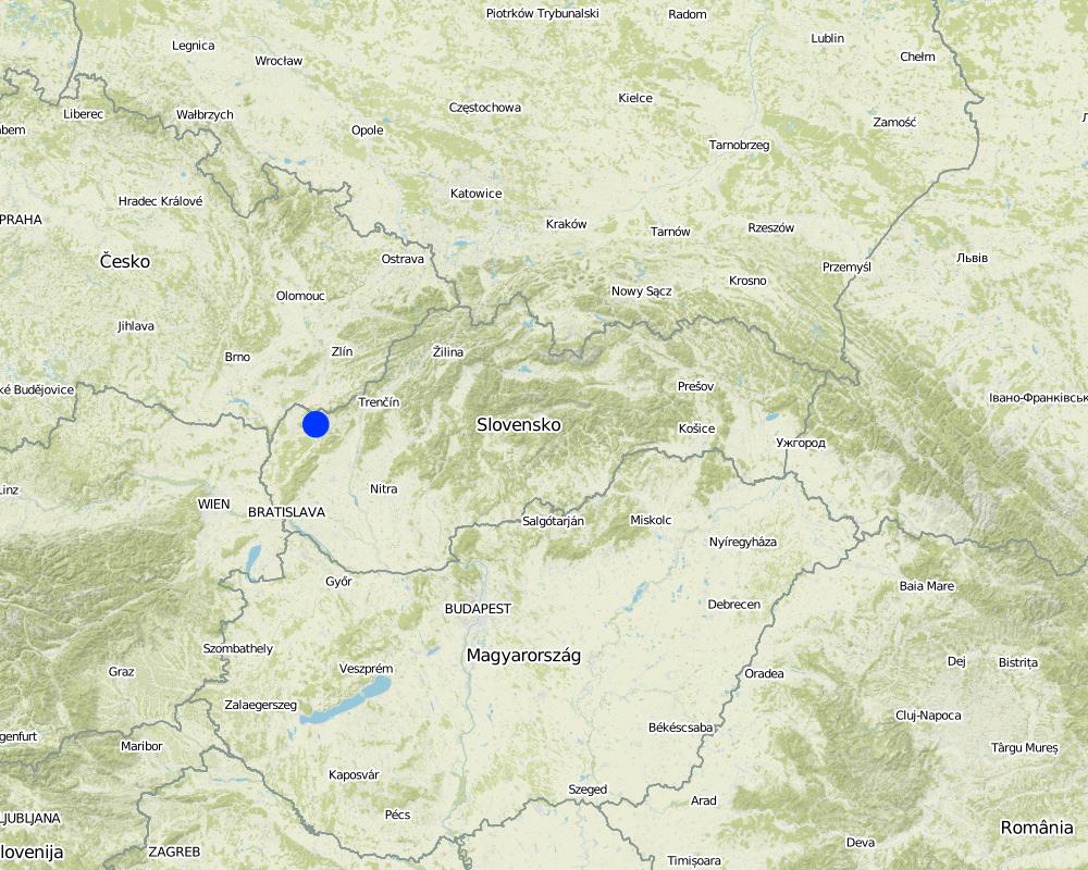
2.5 Country/ region/ locations where the Approach has been applied
Country:
Slovakia
Region/ State/ Province:
Slovakia
Further specification of location:
Senica / Sobotište
Map
×2.6 Dates of initiation and termination of the Approach
Indicate year of initiation:
2011
Year of termination (if Approach is no longer applied):
2012
2.7 Type of Approach
- project/ programme based
2.8 Main aims/ objectives of the Approach
The Approach focused mainly on SLM with other activities
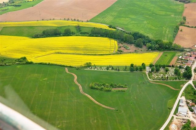
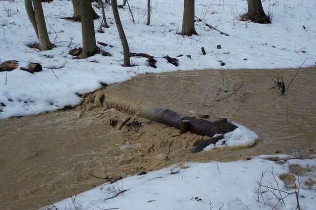
The Sobotište of village was greatly affected in 2011 by floods from storm rainfall. Problems with floods, however, occur regularly, especially at the Teplica and the Sobotišský stream. Some problems have been recorded in farmland and meadows, in places of concentrated runoff during the storm rainfalls, long lasting rainfalls, and snow melting. Floods endanger villages and make severe damage. The goal of the approach is to eliminate damage to healt and properties.
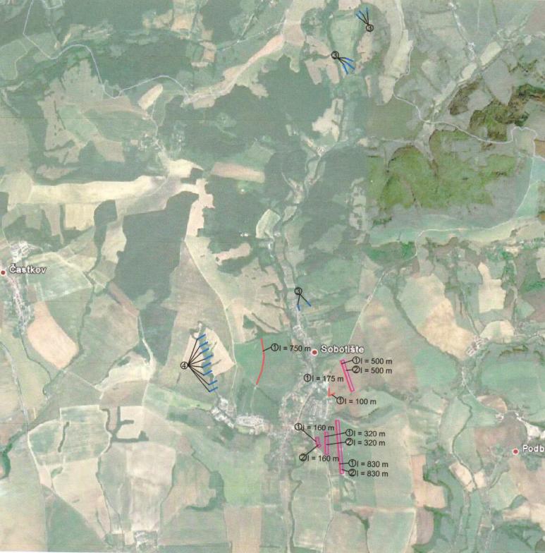
Water retention measures are proposed in the territory of Sobotište, localities of Kubiny, Staré Hory, Javorec, Kaničkov Jarok and Padelky. It is expected that the proposed water retention measures will support the accumulation and infiltration of water into the soil and retard runoff from farmland, meadows, and pastures. With the proper function of measures the surface runoff in farmland will decrease and slow down, and community will not endanger as much as previously.
The SLM Approach addressed the following problems: In general, the main problems within the implementation of projects are mostly legislative regulations that hamper the SLM and the implementation of technologies. The big problem is protection zone of particular rivers connected to administrative and legislative laws and regulations. Some difficulties detected were the execution of permissions for the implementations of methods and technologies that would help to achieve the sustainable land management.
Second problem is land consolidation. The process of the land consolidation is too long to be achieved and accomplished in time. Especially if the public call of the application submission for subsidies needs the consolidation of land to be already solved.
Third, the measures cannot be more expensive than the protected object.
Four, there is lack of money for the purchasing the land in municipalities.
Five, there is very poor law enforcement and recovery of law and claims.
2.9 Conditions enabling or hindering implementation of the Technology/ Technologies applied under the Approach
availability/ access to financial resources and services
- hindering
Treatment through the SLM Approach:
legal framework (land tenure, land and water use rights)
- hindering
ownership of the land
Treatment through the SLM Approach:
3. Participation and roles of stakeholders involved
3.1 Stakeholders involved in the Approach and their roles
- local land users/ local communities
The approach involved socially and economically disadvantaged ethnicities
- SLM specialists/ agricultural advisers
- national government (planners, decision-makers)
3.2 Involvement of local land users/ local communities in the different phases of the Approach
| Involvement of local land users/ local communities | Specify who was involved and describe activities | |
|---|---|---|
| initiation/ motivation | self-mobilization | Government |
| planning | self-mobilization | Government, SLM specialist |
| implementation | self-mobilization | Municipalities, land users |
| monitoring/ evaluation | self-mobilization | Municipalities, land users |
| Research | passive |
3.4 Decision-making on the selection of SLM Technology/ Technologies
Specify who decided on the selection of the Technology/ Technologies to be implemented:
- mainly land users, supported by SLM specialists
Explain:
Decisions on the method of implementing the SLM Technology were made by mainly by land users supported by SLM specialists
4. Technical support, capacity building, and knowledge management
4.1 Capacity building/ training
Was training provided to land users/ other stakeholders?
No
4.2 Advisory service
Do land users have access to an advisory service?
No
4.3 Institution strengthening (organizational development)
Have institutions been established or strengthened through the Approach?
- no
4.4 Monitoring and evaluation
Is monitoring and evaluation part of the Approach?
No
4.5 Research
Was research part of the Approach?
Yes
Specify topics:
- technology
Give further details and indicate who did the research:
Research was carried out on-farm
5. Financing and external material support
5.1 Annual budget for the SLM component of the Approach
If precise annual budget is not known, indicate range:
- 10,000-100,000
Comments (e.g. main sources of funding/ major donors):
Approach costs were met by the following donors: government: 100.0%
5.2 Financial/ material support provided to land users
Did land users receive financial/ material support for implementing the Technology/ Technologies?
Yes
If yes, specify type(s) of support, conditions, and provider(s):
Government funds and subsidies
5.3 Subsidies for specific inputs (including labour)
- equipment
| Specify which inputs were subsidised | To which extent | Specify subsidies |
|---|---|---|
| machinery | fully financed | |
| tools | fully financed | |
- agricultural
| Specify which inputs were subsidised | To which extent | Specify subsidies |
|---|---|---|
| seeds | fully financed | |
| fertilizers | fully financed | |
- construction
| Specify which inputs were subsidised | To which extent | Specify subsidies |
|---|---|---|
| stone | fully financed | |
| wood | fully financed | |
5.4 Credit
Was credit provided under the Approach for SLM activities?
No
7. References and links
7.1 Methods/ sources of information
- field visits, field surveys
- interviews with land users
Links and modules
Expand all Collapse allLinks
Level ditches in cropland [Slovakia]
Conservation measures for eroded cropland. The technology contains level ditches of various lengths, which are digged along a contour.
- Compiler: Zuzana Studvova
Wooden check dams [Slovakia]
Small wooden check dams built in erosion rills, grooves or gorges to reduce flood risk.
- Compiler: Zuzana Studvova
Modules
No modules