Integrated disaster risk reduction in flood-affected areas by local communities [Tajikistan]
- Creation:
- Update:
- Compiler: Stefan Michel
- Editor: –
- Reviewer: Umed Vahobov
Интегрированный подход к снижению риска стихийных бедствий местными сообществами, в местностях подверженным селевым потокам
approaches_4319 - Tajikistan
View sections
Expand all Collapse all1. General information
1.2 Contact details of resource persons and institutions involved in the assessment and documentation of the Approach
Key resource person(s)
SLM specialist:
Muhidinov Nodir
nodir.sfl@gmail.com
Deutsche Gesellschaft für Internationale Zusammenarbeit (GIZ)
Tajikistan
Name of project which facilitated the documentation/ evaluation of the Approach (if relevant)
Strengthening of Livelihoods through Climate Change Adaptation in Kyrgyzstan and TajikistanName of the institution(s) which facilitated the documentation/ evaluation of the Approach (if relevant)
Deutsche Gesellschaft für Internationale Zusammenarbeit - Tajikistan (GIZ Tajikistan) - Tajikistan1.3 Conditions regarding the use of data documented through WOCAT
The compiler and key resource person(s) accept the conditions regarding the use of data documented through WOCAT:
Yes
1.4 Reference(s) to Questionnaire(s) on SLM Technologies
Prevention of riverbank erosion by combination of green … [Tajikistan]
Flashfloods in riverbeds cause intensive riverbank erosion, which threatens villages, infrastructure and productive lands. Preventive measures combining "grey" (physical structures) and "green" (living trees) elements are more effective, sustainable and cost efficient than constructive measures only.
- Compiler: Stefan Michel
2. Description of the SLM Approach
2.1 Short description of the Approach
Climate change and land degradation in upper catchment areas cause an increasing frequency and intensity of flash flood and debris flows affecting settlements and productive areas. GIZ in collaboration with the Committee on Emergency Situations assisted local communities in the implementation of integrated preventive measures.
2.2 Detailed description of the Approach
Detailed description of the Approach:
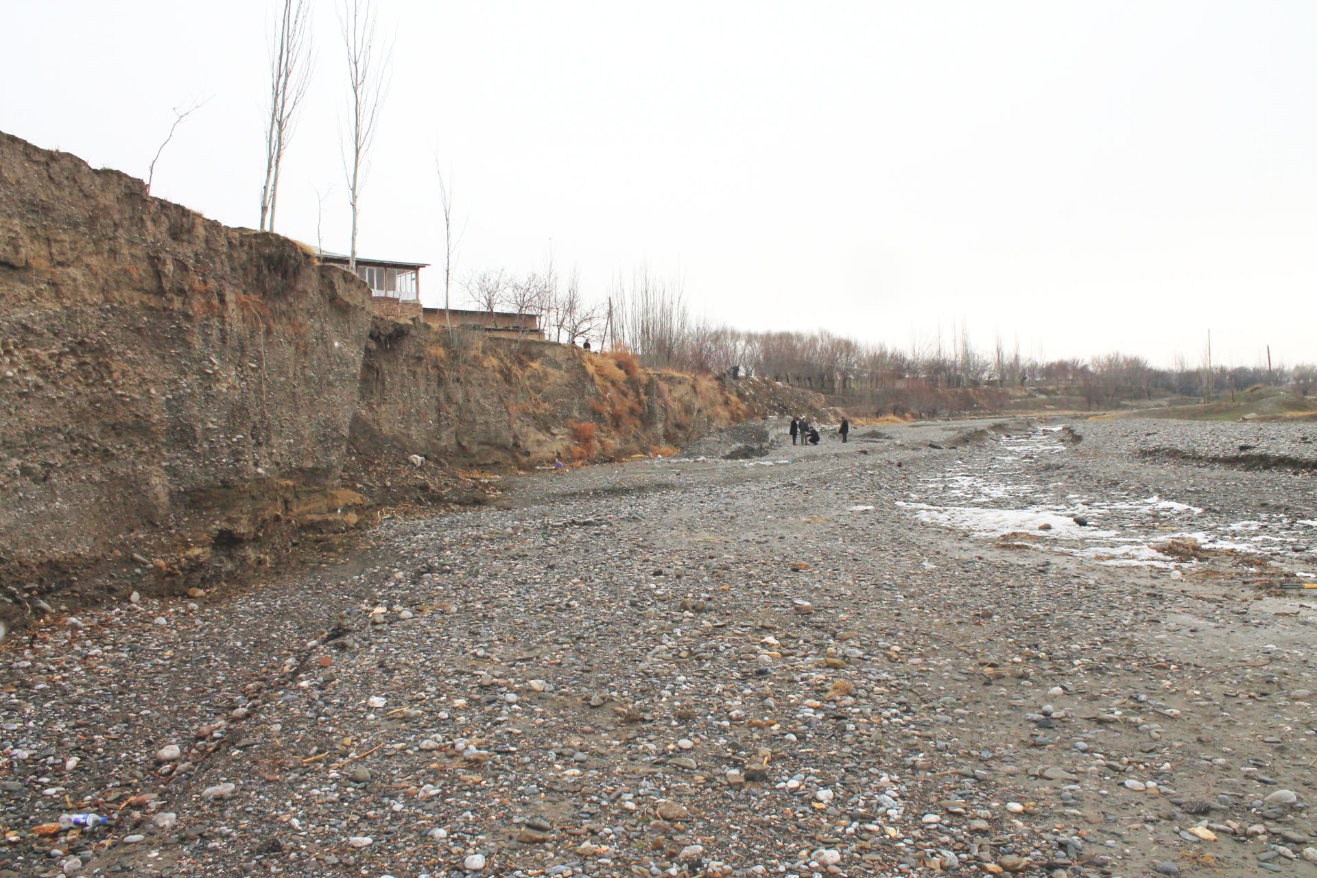
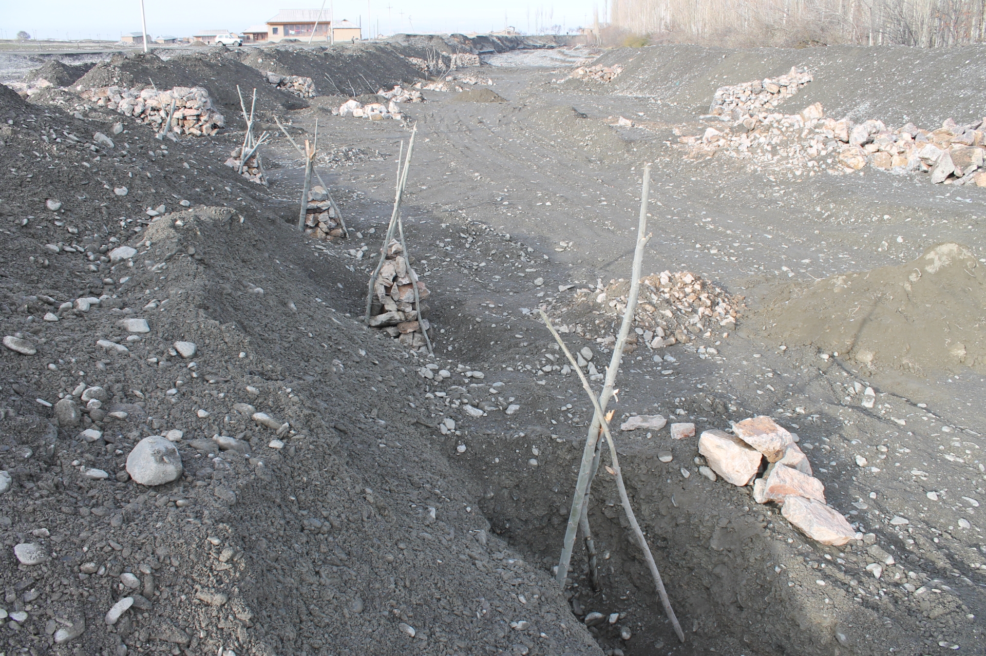
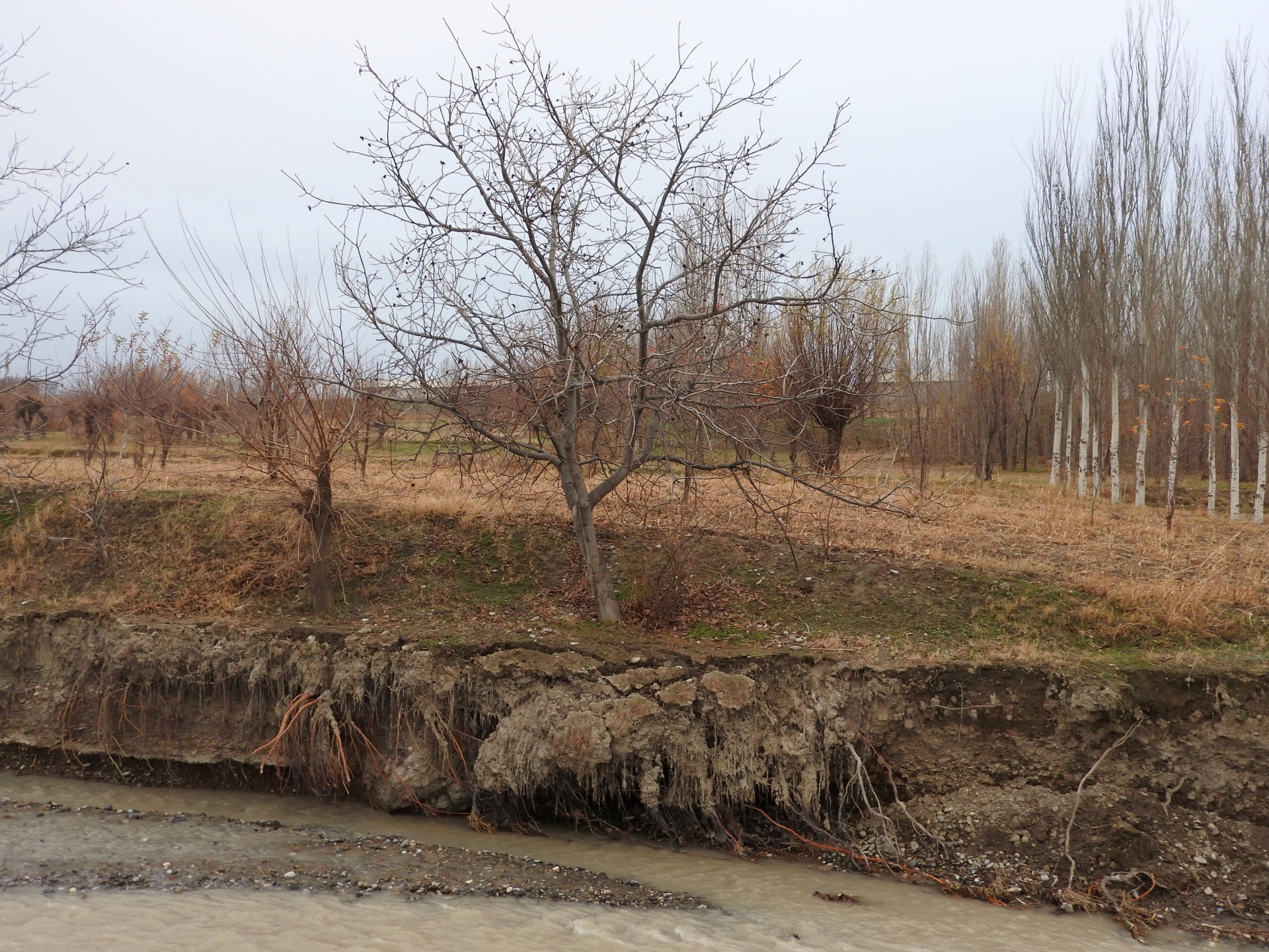
Villages and associated productive lands like orchards, gardens and arable fields in the lower parts of the northern main slope of the Turkestan mountain range are typically located in the valleys of rivers and streams. Water discharge in these rivers and streams is seasonally highly variable. During the wet season water flow is very high, while during the dry summer and fall months almost no water is visible at the surface and the limited discharge takes place in the gravel of the riverbed. After rainfall and during snowmelt extreme flow events happen with discharges several times exceeding the average of the wet season. Flashfloods with high speed and energy typically cause the transportation of large amounts of debris. These debris flows can be much more destructive than ordinary high water events. The resulting riverbank erosion is in some extent a natural element of the morphological dynamic of rivers and streams.
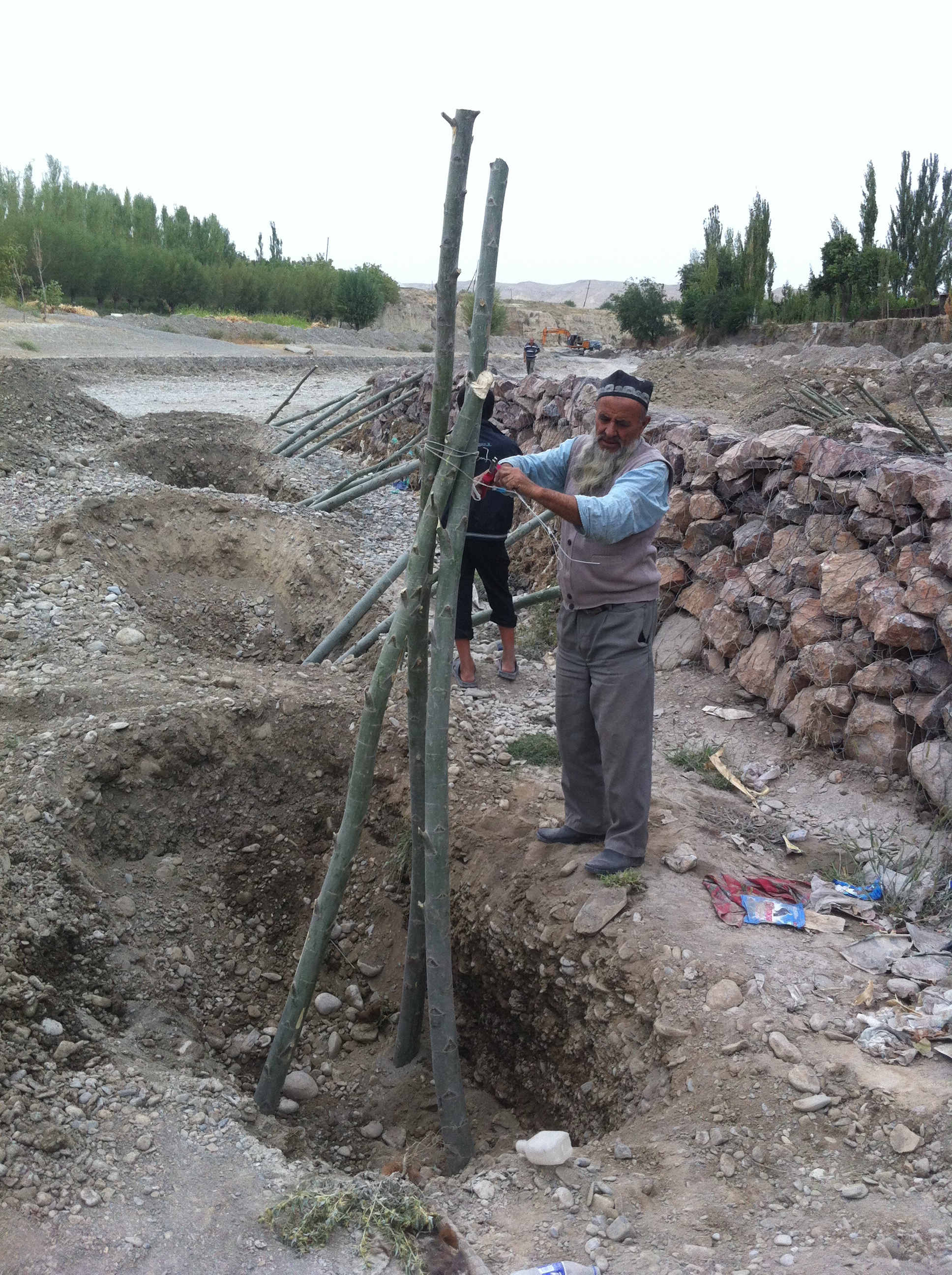
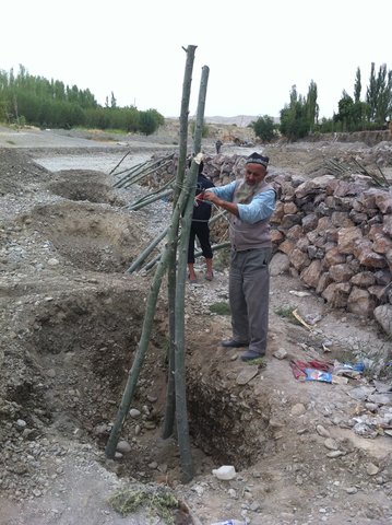
Land-use related factors have increased the vulnerability of communities to these flashfloods and debris flows as well as their destructiveness. Population growth, the expansion of settlements and the reclamation of more lands for irrigated orchards, gardens and arable fields have brought more people and values into potentially risky areas. The degradation of the vegetation in upper catchments has contributed to reduced infiltration of water and high and fast surface runoff. The riparian forests and woodlands which in some extent slow down flashfloods and keep sediment have been largely destroyed by clearing, livestock grazing and by the increasing intensity of flashflood events.
These problems are increasingly exacerbated by the impact of climate change. The already visible trends and predictions show higher levels of aridity, higher temperatures during the vegetation season, reduced overall precipitation in catchment areas – all affecting the retention potential of upper catchment areas – and more irregular rainfall patterns, reduced snow packs and accelerated snow melt as well as the loss of glaciers as buffers of water flow. These factors all contribute to a higher frequency and intensity of flashflood and debris flows.
These events threaten settlements, infrastructure and human lives, but they also pose substantial risks to the stability and functioning of irrigation canals, cause irreversibly losses of productive lands and thus threaten livelihoods of farmers and food security.
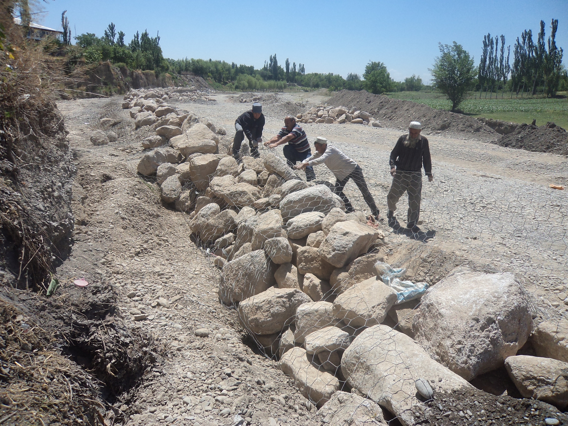
The approach brought together the Committee of Emergency Situations, affected local people and the administrative communities, the mahalla committees, which represent the inhabitants of one village or a section of a larger village. These institutions are called communal self-governance structures, but are subordinated to the government as they are reporting to the sub-district or jamoat. Assisted by experts provided by the project, the situation was jointly analyzed; risks identified and integrated intervention planned. Typically the interventions consisted of a combination of “grey” (i.e. constructive structures) and “green” (i.e. protective vegetation) measures. Most of the upper catchment areas belong to different communities, often to different districts and substantial parts are located in neighboring Kyrgyzstan. Therefore addressing the degradation of these areas and a reduction of disaster risk through integrated watershed management in the entire catchments was rarely possible.
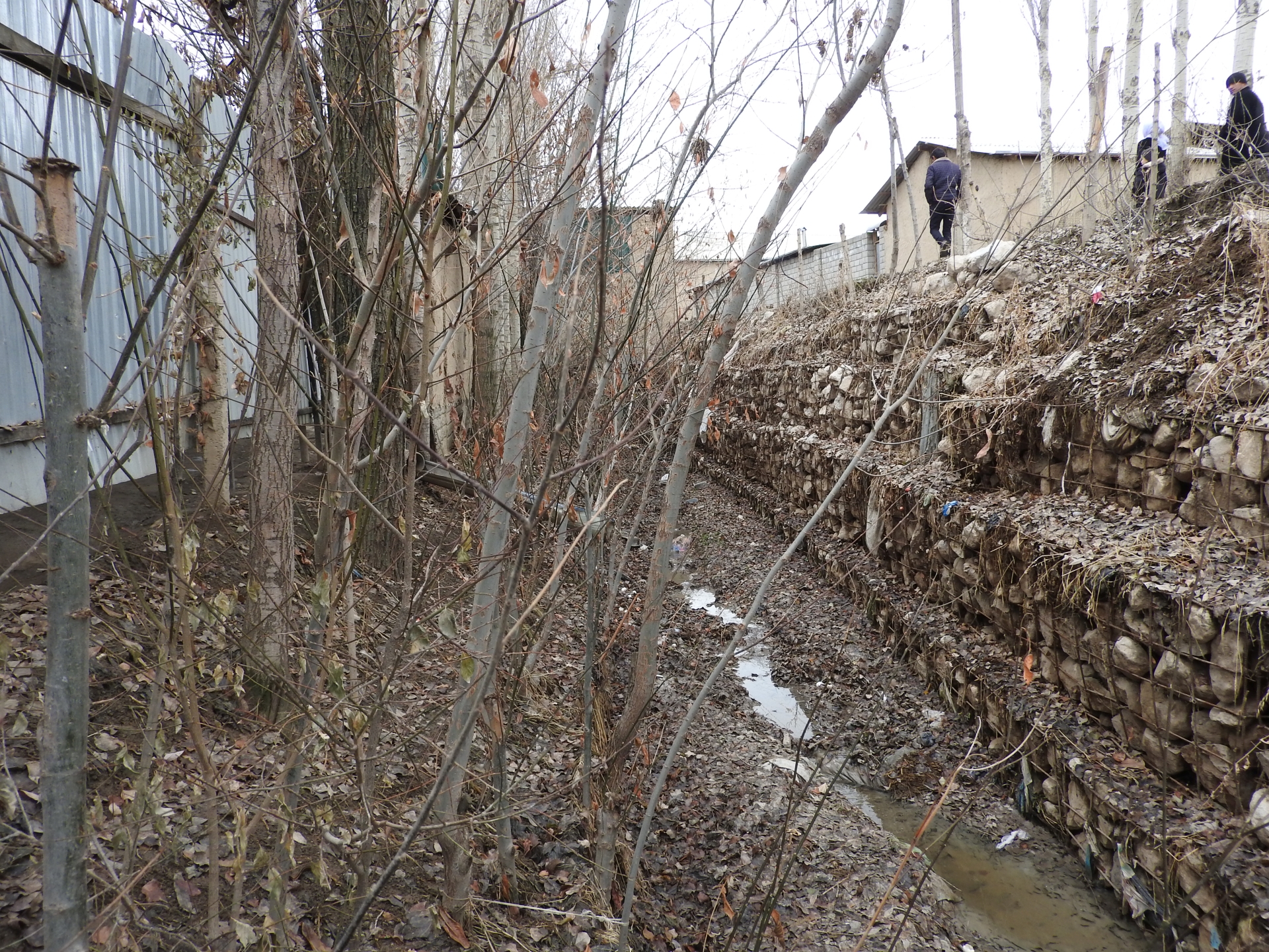
The project assisted with technical planning, construction supervision, purchase and transportation of construction materials. The communities would contribute about 30% of the overall costs, mainly in form of voluntary communal work, the so called hashar, as well as in form of locally available construction materials. The community is also in charge of future operation and maintenance of the riverbank protection structures.
2.3 Photos of the Approach
Media Gallery
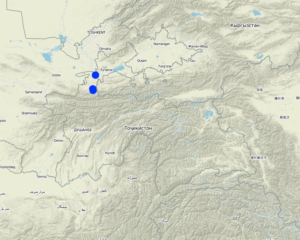
2.5 Country/ region/ locations where the Approach has been applied
Country:
Tajikistan
Region/ State/ Province:
Sughd region
Further specification of location:
Spitamen district, Devashtich district
Map
×2.6 Dates of initiation and termination of the Approach
Indicate year of initiation:
2014
If precise year is not known, indicate approximate date when the Approach was initiated:
less than 10 years ago (recently)
2.7 Type of Approach
- project/ programme based
2.8 Main aims/ objectives of the Approach
Prevention of disasters caused by flashfloods and debris flows
2.9 Conditions enabling or hindering implementation of the Technology/ Technologies applied under the Approach
availability/ access to financial resources and services
- hindering
Communities and Committee of Emergency Situations without external assistance not able to implement effective integrated measures.
institutional setting
- enabling
Good collaboration between communities and Committee of Emergency Situations.
collaboration/ coordination of actors
- enabling
Good collaboration between communities and Committee of Emergency Situations.
knowledge about SLM, access to technical support
- hindering
Insufficient knowledge in communities about effective technololgy.
workload, availability of manpower
- enabling
Traditional joint volunteer work in communities for addressing common problems (hashar).
3. Participation and roles of stakeholders involved
3.1 Stakeholders involved in the Approach and their roles
- local land users/ local communities
Inhabitants of village
Participation in identification of risk sites;
Volunteer work
- SLM specialists/ agricultural advisers
Engineers provided by GIZ
Identification of risk sites;
Design, planning and supervision of interventions.
- local government
District branches of Committee for Emergency Situations
Participation in identification of risk sites;
Agreement of plans for interventions
3.2 Involvement of local land users/ local communities in the different phases of the Approach
| Involvement of local land users/ local communities | Specify who was involved and describe activities | |
|---|---|---|
| initiation/ motivation | interactive | Participation in identification of risk sites; |
| planning | interactive | Participation in discussion of interventions; |
| implementation | interactive | Volunteer work |
| monitoring/ evaluation | interactive | Control of conditions and functioning of protective structures |
3.4 Decision-making on the selection of SLM Technology/ Technologies
Specify who decided on the selection of the Technology/ Technologies to be implemented:
- all relevant actors, as part of a participatory approach
4. Technical support, capacity building, and knowledge management
4.1 Capacity building/ training
Was training provided to land users/ other stakeholders?
No
4.2 Advisory service
Do land users have access to an advisory service?
Yes
Describe/ comments:
Not involved in this approach
4.3 Institution strengthening (organizational development)
Have institutions been established or strengthened through the Approach?
- yes, a little
Specify the level(s) at which institutions have been strengthened or established:
- local
Describe institution, roles and responsibilities, members, etc.
Strengthening of community institutions in addressing issues of common concern.
Specify type of support:
- capacity building/ training
4.4 Monitoring and evaluation
Is monitoring and evaluation part of the Approach?
Yes
If yes, is this documentation intended to be used for monitoring and evaluation?
No
4.5 Research
Was research part of the Approach?
No
5. Financing and external material support
5.1 Annual budget for the SLM component of the Approach
If precise annual budget is not known, indicate range:
- 10,000-100,000
Comments (e.g. main sources of funding/ major donors):
Government of Germany, implemented via Deutsche Gesellschaft für Internationale Zusammenarbeit (GIZ). The approach has been implemented in the frame of a much larger program and the specific budget for the SLM component of the Approach cannot be determined.
5.2 Financial/ material support provided to land users
Did land users receive financial/ material support for implementing the Technology/ Technologies?
Yes
If yes, specify type(s) of support, conditions, and provider(s):
Costs of planning, design and supervision, costs of materials, transportation and machinery covered by GIZ.
5.3 Subsidies for specific inputs (including labour)
- equipment
| Specify which inputs were subsidised | To which extent | Specify subsidies |
|---|---|---|
| machinery | fully financed | |
- construction
| Specify which inputs were subsidised | To which extent | Specify subsidies |
|---|---|---|
| stone | partly financed | |
| Gabion nets | fully financed | |
If labour by land users was a substantial input, was it:
- voluntary
5.4 Credit
Was credit provided under the Approach for SLM activities?
No
5.5 Other incentives or instruments
Were other incentives or instruments used to promote implementation of SLM Technologies?
No
6. Impact analysis and concluding statements
6.1 Impacts of the Approach
Did the Approach empower local land users, improve stakeholder participation?
- No
- Yes, little
- Yes, moderately
- Yes, greatly
People mobilized to address common issues.
Did the Approach help land users to implement and maintain SLM Technologies?
- No
- Yes, little
- Yes, moderately
- Yes, greatly
Grey and geeen measures for prevention of riverbank erosion
Did the Approach improve coordination and cost-effective implementation of SLM?
- No
- Yes, little
- Yes, moderately
- Yes, greatly
Did the Approach mobilize/ improve access to financial resources for SLM implementation?
- No
- Yes, little
- Yes, moderately
- Yes, greatly
Combination of financial and technical support by GIZ and contributions in form of work and locally available materials by community members.
Did the Approach improve knowledge and capacities of land users to implement SLM?
- No
- Yes, little
- Yes, moderately
- Yes, greatly
Community members capable of replicating the technologies.
Did the Approach improve knowledge and capacities of other stakeholders?
- No
- Yes, little
- Yes, moderately
- Yes, greatly
Committee of Emergency Situations capable of replicating the technologies.
Improved collaboration between Committe of Emergency Situations, communal self-governance and community members.
Did the Approach encourage young people/ the next generation of land users to engage in SLM?
- No
- Yes, little
- Yes, moderately
- Yes, greatly
Involvement of young people in joint work
Did the Approach lead to improved food security/ improved nutrition?
- No
- Yes, little
- Yes, moderately
- Yes, greatly
Reduced risk of destruction of irrigation infrastructure and of loss of productive lands.
Did the Approach improve the capacity of the land users to adapt to climate changes/ extremes and mitigate climate related disasters?
- No
- Yes, little
- Yes, moderately
- Yes, greatly
Reduced risk of destructive impacts of flashfloods and debris flows, which due to climate change are increasing in frequency and intensity.
6.2 Main motivation of land users to implement SLM
- reduced risk of disasters
6.3 Sustainability of Approach activities
Can the land users sustain what has been implemented through the Approach (without external support)?
- yes
6.4 Strengths/ advantages of the Approach
| Strengths/ advantages/ opportunities in the land user’s view |
|---|
| Reduced disaster risk |
| Availability of wood from green measures |
| Strengths/ advantages/ opportunities in the compiler’s or other key resource person’s view |
|---|
| Same as land-users |
| Improved collaboration at local level and strengthened institutions |
| Ownership feeling among community members |
6.5 Weaknesses/ disadvantages of the Approach and ways of overcoming them
| Weaknesses/ disadvantages/ risks in the land user’s view | How can they be overcome? |
|---|---|
| None |
| Weaknesses/ disadvantages/ risks in the compiler’s or other key resource person’s view | How can they be overcome? |
|---|---|
| None |
7. References and links
7.1 Methods/ sources of information
- field visits, field surveys
- interviews with land users
- interviews with SLM specialists/ experts
- compilation from reports and other existing documentation
Links and modules
Expand all Collapse allLinks
Prevention of riverbank erosion by combination of green … [Tajikistan]
Flashfloods in riverbeds cause intensive riverbank erosion, which threatens villages, infrastructure and productive lands. Preventive measures combining "grey" (physical structures) and "green" (living trees) elements are more effective, sustainable and cost efficient than constructive measures only.
- Compiler: Stefan Michel
Modules
No modules