Growing of fodder crops on steep slopes in arid highlands [Tajikistan]
- Creation:
- Update:
- Compiler: Gulniso Nekushoeva
- Editor: –
- Reviewers: David Streiff, Alexandra Gavilano, Joana Eichenberger
Парвариши алафхои бисьерсола (юнучка) дар нишебихои ростфуромадагии минтакахои баландкухои хушк
technologies_1028 - Tajikistan
- Full summary as PDF
- Full summary as PDF for print
- Full summary in the browser
- Full summary (unformatted)
- Growing of fodder crops on steep slopes in arid highlands: Nov. 2, 2021 (public)
- Growing of fodder crops on steep slopes in arid highlands: Aug. 14, 2019 (inactive)
- Growing of fodder crops on steep slopes in arid highlands: July 19, 2017 (inactive)
- Growing of fodder crops on steep slopes in arid highlands: July 19, 2017 (inactive)
- Growing of fodder crops on steep slopes in arid highlands: March 14, 2017 (inactive)
View sections
Expand all Collapse all1. General information
1.2 Contact details of resource persons and institutions involved in the assessment and documentation of the Technology
Key resource person(s)
SLM specialist:
SLM specialist:
land user:
Gulomshoev Burkhvalisho
Tajikistan
1.3 Conditions regarding the use of data documented through WOCAT
The compiler and key resource person(s) accept the conditions regarding the use of data documented through WOCAT:
Yes
2. Description of the SLM Technology
2.1 Short description of the Technology
Definition of the Technology:
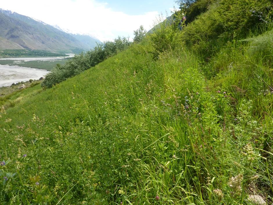
Cultivation of fodder crops (alfa-аlfa) on irrigated slopes of 60% steepness in the arid mountainous area of the Western Pamirs (Vanj valley).
2.2 Detailed description of the Technology
Description:
In 1993, in the Vanj district all land suitable for tilling was already occupied, only steep slopes were uncultivated. However, one innovative land user began to set up on a slope with 60% steepness, a 3 ha plot for intensive grass / fodder production through his own initiative. By the application of irrigation, within 3-5 years the very low productive grazing land was converted into a highly productive and sustainable cut-and-carry system. The technology is very effective in these ecological conditions for rapid rehabilitation of degraded lands. Over the 18 years of on-going fodder production on the plot, the pure alfa-alfa culture transformed into a grass-bean mixture, which provides even better soil cover and soil conservation.
Purpose of the Technology: The main purpose is secured fodder production for keeping livestock in the winter time. Despite the steep slope of 60%, and low-productive soils, by applying irrigation, the farmer gets three harvests of hay per season, amounting to about 8-12 ton of high quality fodder. Thus, over all these years, the farmer has had no problems producing sufficient fodder for his livestock.
Establishment / maintenance activities and inputs: The establishment of such a plot is very labour-intensive. However, within 3-4 years the productivity of the land improves several times over. High yields of high quality hay can be obtained within the short term, and the labour intensive activities are mostly needed just within the first year of establishment. Thus, many farmers have been attracted to apply this technology.
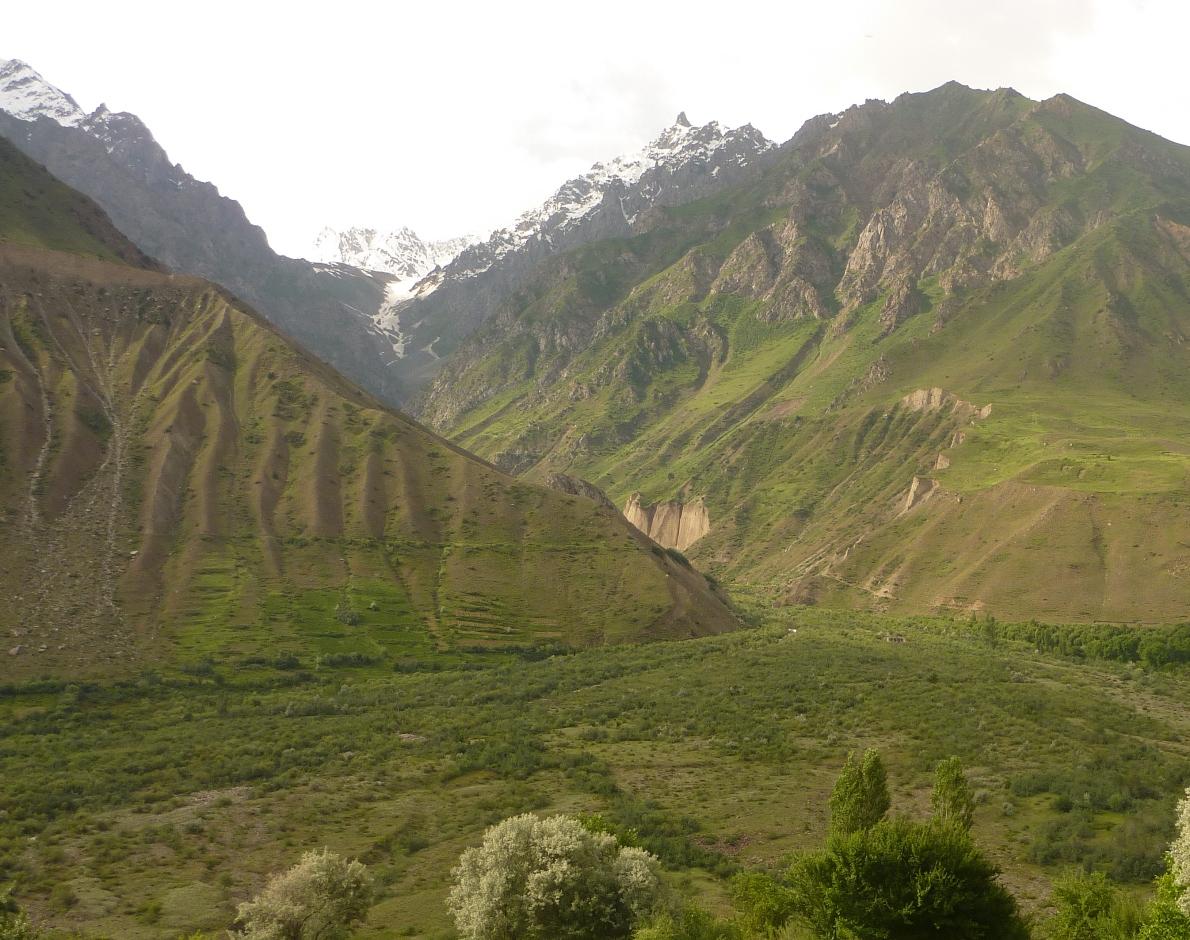
Natural / human environment: The plot described is situated in the village of Ravgada, Jamoat Teharv in Vanj district. Vanj is one of the two districts of GBAO with favourable agro-climatic conditions. But even here the natural fertility of the stony soils is low, especially on pasture lands with sparse vegetation. Due to the high aridity, farming is not possible without irrigation. The main income of the population is from livestock and the sale of nuts and fruits. All families that have recently become independent farmers, had mostly lands on steep slopes allocated to them. These families have therefore been applying the described technology with minor variations depending on the topography of their land.
2.3 Photos of the Technology
Media Gallery
2.5 Country/ region/ locations where the Technology has been applied and which are covered by this assessment
Country:
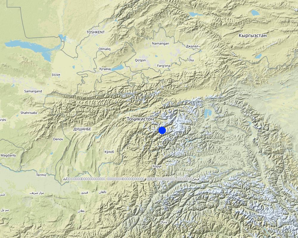
Tajikistan
Region/ State/ Province:
Tajikistan / GBAO
Further specification of location:
Vanch / Ravgada
Specify the spread of the Technology:
- evenly spread over an area
If precise area is not known, indicate approximate area covered:
- < 0.1 km2 (10 ha)
Comments:
Total area covered by the SLM Technology is 0.03 km2.
Map
×2.6 Date of implementation
If precise year is not known, indicate approximate date:
- 10-50 years ago
2.7 Introduction of the Technology
Specify how the Technology was introduced:
- through land users' innovation
Comments (type of project, etc.):
The technology was established in 1992.
3. Classification of the SLM Technology
3.1 Main purpose(s) of the Technology
- improve production
3.2 Current land use type(s) where the Technology is applied

Cropland
- Annual cropping
- Perennial (non-woody) cropping
Annual cropping - Specify crops:
- legumes and pulses - beans
- fodder crops - alfalfa
Number of growing seasons per year:
- 1
Specify:
Longest growing period in days: 180Longest growing period from month to month: April-September

Grazing land
Intensive grazing/ fodder production:
- Cut-and-carry/ zero grazing

Forest/ woodlands
Products and services:
- Fruits and nuts
Comments:
Major land use problems (compiler’s opinion): Low natural fertility of soils, very stony land, farming is not possible without irrigation.
Major land use problems (land users’ perception): Lack of water. A lot of money and work is required to supply water to areas on steep slopes.
Future (final) land use (after implementation of SLM Technology): Grazing land: Gi: Intensive grazing/ fodder production
3.3 Has land use changed due to the implementation of the Technology?
Grazing land
Comments:
Future (final) land use (after implementation of SLM Technology): Grazing land: Gi: Intensive grazing/ fodder production
3.4 Water supply
Water supply for the land on which the Technology is applied:
- full irrigation
3.5 SLM group to which the Technology belongs
- improved ground/ vegetation cover
- improved plant varieties/ animal breeds
3.6 SLM measures comprising the Technology

agronomic measures
- A1: Vegetation/ soil cover

vegetative measures
- V2: Grasses and perennial herbaceous plants

structural measures
- S3: Graded ditches, channels, waterways

management measures
- M1: Change of land use type
Comments:
Main measures: vegetative measures
Secondary measures: structural measures
Type of vegetative measures: in blocks
3.7 Main types of land degradation addressed by the Technology

soil erosion by water
- Wt: loss of topsoil/ surface erosion
- Wg: gully erosion/ gullying

chemical soil deterioration
- Cn: fertility decline and reduced organic matter content (not caused by erosion)

biological degradation
- Bc: reduction of vegetation cover

water degradation
- Ha: aridification
Comments:
Main type of degradation addressed: Wt: loss of topsoil / surface erosion, Cn: fertility decline and reduced organic matter content, Bc: reduction of vegetation cover
Secondary types of degradation addressed: Wg: gully erosion / gullying, Ha: aridification
Main causes of degradation: overgrazing (grazing without rotation), droughts (High aridity, low precipitation), other natural causes (avalanches, volcanic eruptions, mud flows, highly susceptible natural resources, extreme topography, etc.) specify (very steep slopes (all other land was already occupied)), population pressure (lack of land), poverty / wealth (not enough resources)
Secondary causes of degradation: crop management (annual, perennial, tree/shrub) (fields with perennial crops are not wide spread), deforestation / removal of natural vegetation (incl. forest fires) (tree cutting for fuel), labour availability (migration to Russia), inputs and infrastructure: (roads, markets, distribution of water points, other, …) (no direct access to markets), education, access to knowledge and support services (no institutional support), war and conflicts (main cause for food unsecurity)
3.8 Prevention, reduction, or restoration of land degradation
Specify the goal of the Technology with regard to land degradation:
- reduce land degradation
- restore/ rehabilitate severely degraded land
Comments:
Main goals: mitigation / reduction of land degradation
Secondary goals: prevention of land degradation, rehabilitation / reclamation of denuded land
4. Technical specifications, implementation activities, inputs, and costs
4.1 Technical drawing of the Technology
Technical specifications (related to technical drawing):
Technical knowledge required for land users: moderate (creating an irrigation system on such a steep slope requires knowledge)
Main technical functions: reduction of slope length, improvement of ground cover, increase in organic matter, increase in nutrient availability (supply, recycling,…), increase of biomass (quantity)
Secondary technical functions: control of dispersed runoff: retain / trap, control of dispersed runoff: impede / retard, control of concentrated runoff: retain / trap, improvement of surface structure (crusting, sealing), stabilisation of soil (eg by tree roots against land slides), increase / maintain water stored in soil, water harvesting / increase water supply, promotion of vegetation species and varieties (quality, eg palatable fodder)
Aligned: -graded strips
Vegetative material: C : perennial crops
In blocks
Vegetative material: C : perennial crops
Number of plants per (ha): 16kg/ha
Trees/ shrubs species: naturally grown along irrigation canals: Dog rose, sea buckthorn
Perennial crops species: alfa-alfa
Grass species: natural grasses
Slope (which determines the spacing indicated above): 60.00%
Gradient along the rows / strips: 60.00%
Structural measure: digging irrigation canal
Depth of ditches/pits/dams (m): 50
Width of ditches/pits/dams (m): 50
Length of ditches/pits/dams (m): 3000
Construction material (earth): first irrigation canals were dug into the earth
Construction material (stone): collected from the field stones were lined along the irrigation canals
4.2 General information regarding the calculation of inputs and costs
other/ national currency (specify):
somoni
If relevant, indicate exchange rate from USD to local currency (e.g. 1 USD = 79.9 Brazilian Real): 1 USD =:
4.53
Indicate average wage cost of hired labour per day:
6.60
4.3 Establishment activities
| Activity | Timing (season) | |
|---|---|---|
| 1. | Clearing the site of stones | before plowing |
| 2. | Clearing the site of stones | before plowing |
| 3. | plowing the land using ox | Spring / 1 time in 19 years |
| 4. | plowing the land using ox | Spring / 1 time in 19 years |
| 5. | Purchasing fertilisers(50 kg=150s) | |
| 6. | Purchasing fertilisers(50 kg=150s) | |
| 7. | Applying fertilisers | before sowing |
| 8. | Applying fertilisers | before sowing |
| 9. | alfa-alfa seeds | |
| 10. | alfa-alfa seeds | |
| 11. | planting (sowing) alfalfa | |
| 12. | planting (sowing) alfalfa | |
| 13. | watering the field | |
| 14. | watering the field | |
| 15. | Construction of main irrigation canal(pipes water from a spring) | |
| 16. | Construction of main irrigation canal(pipes water from a spring) | |
| 17. | Purchasing of pipes20 Ø= 50cm x 6m1=100$ | |
| 18. | Purchasing of pipes20 Ø= 50cm x 6m1=100$ | |
| 19. | installation of pipesover a length of 120m | |
| 20. | installation of pipesover a length of 120m | |
| 21. | Construction ofirrigation network on site | before sowing |
| 22. | Construction ofirrigation network on site | before sowing |
| 23. | stabilisation of irrigation canals with stones collected from the fields | after plowing |
| 24. | stabilisation of irrigation canals with stones collected from the fields | after plowing |
4.4 Costs and inputs needed for establishment
| Specify input | Unit | Quantity | Costs per Unit | Total costs per input | % of costs borne by land users | |
|---|---|---|---|---|---|---|
| Labour | Clearing the site of stones | Persons/day | 10.0 | 30.0 | 300.0 | 100.0 |
| Labour | Plowing the land with ox | Persons/day | 9.0 | 180.0 | 1620.0 | 100.0 |
| Labour | Applying Fertilizer/planting alfalfa/watering | Persons/day | 13.0 | 30.0 | 390.0 | 100.0 |
| Labour | Construction of irrigation pipes | Persons/day | 304.0 | 30.0 | 9120.0 | 100.0 |
| Equipment | Purchasing of pipes 20 Ø= 50cm x 6m 1=100$ | pipes | 20.0 | 453.0 | 9060.0 | 100.0 |
| Equipment | Labour: Constructing and stabilizing irrigation network (3km) | Persons/day | 450.0 | 30.0 | 13500.0 | 100.0 |
| Plant material | Alfa-alfa seeds | kg | 48.0 | 20.0 | 960.0 | 100.0 |
| Fertilizers and biocides | Fertilizer | kg | 500.0 | 3.0 | 1500.0 | 100.0 |
| Total costs for establishment of the Technology | 36450.0 | |||||
| Total costs for establishment of the Technology in USD | 8046.36 | |||||
Comments:
Duration of establishment phase: 1 month(s)
4.5 Maintenance/ recurrent activities
| Activity | Timing/ frequency | |
|---|---|---|
| 1. | watering the field10 times per vegetation period (5 month).Once, every 9 days for 3 ha. | during vegetation period |
| 2. | cutting of alfa-alfa and natural grass | 3 times per year |
| 3. | Repairing and cleaning of the main irrigation canal from sediments and debris | Before the irrigation season in spring |
| 4. | repairing and cleaning of the irrigation network from sediment and branches on an overall area of 3 ha | Before the irrigation season in spring |
4.6 Costs and inputs needed for maintenance/ recurrent activities (per year)
| Specify input | Unit | Quantity | Costs per Unit | Total costs per input | % of costs borne by land users | |
|---|---|---|---|---|---|---|
| Labour | watering the field 10 times per vegetation period | Persons/day | 90.0 | 30.0 | 2700.0 | 100.0 |
| Labour | cutting of alfa-alfa and natural grass | Persons/day | 45.0 | 30.0 | 1350.0 | 100.0 |
| Labour | Cleaning irrigation network and canal | Persons/day | 12.0 | 30.0 | 360.0 | 100.0 |
| Total costs for maintenance of the Technology | 4410.0 | |||||
| Total costs for maintenance of the Technology in USD | 973.51 | |||||
Comments:
Machinery/ tools: manual labour using sickle/shovel., shovels
The slope of the plot described is 55-60%.
4.7 Most important factors affecting the costs
Describe the most determinate factors affecting the costs:
The steepness of the slope.
5. Natural and human environment
5.1 Climate
Annual rainfall
- < 250 mm
- 251-500 mm
- 501-750 mm
- 751-1,000 mm
- 1,001-1,500 mm
- 1,501-2,000 mm
- 2,001-3,000 mm
- 3,001-4,000 mm
- > 4,000 mm
Agro-climatic zone
- arid
Thermal climate class: subtropics
5.2 Topography
Slopes on average:
- flat (0-2%)
- gentle (3-5%)
- moderate (6-10%)
- rolling (11-15%)
- hilly (16-30%)
- steep (31-60%)
- very steep (>60%)
Landforms:
- plateau/plains
- ridges
- mountain slopes
- hill slopes
- footslopes
- valley floors
Altitudinal zone:
- 0-100 m a.s.l.
- 101-500 m a.s.l.
- 501-1,000 m a.s.l.
- 1,001-1,500 m a.s.l.
- 1,501-2,000 m a.s.l.
- 2,001-2,500 m a.s.l.
- 2,501-3,000 m a.s.l.
- 3,001-4,000 m a.s.l.
- > 4,000 m a.s.l.
Comments and further specifications on topography:
Altitudinal zone: More exactly 2150-2200m
Lanforms: Straight steep slope in high mountain area
Slopes on average: 60% steepness on the upper part of the plot, and 50-55% on the lower part.
5.3 Soils
Soil depth on average:
- very shallow (0-20 cm)
- shallow (21-50 cm)
- moderately deep (51-80 cm)
- deep (81-120 cm)
- very deep (> 120 cm)
Soil texture (topsoil):
- medium (loamy, silty)
Topsoil organic matter:
- medium (1-3%)
If available, attach full soil description or specify the available information, e.g. soil type, soil PH/ acidity, Cation Exchange Capacity, nitrogen, salinity etc.
Soil fertility is low
Soil drainage / infiltration is good
Soil water storage capacity is medium
5.4 Water availability and quality
Ground water table:
> 50 m
Water quality (untreated):
good drinking water
Comments and further specifications on water quality and quantity:
Ground water table: It is a steep mountain slope
Water quality (untreated): Water comes from a spring, it is good drinking water
5.5 Biodiversity
Species diversity:
- high
Comments and further specifications on biodiversity:
Much evidence of insects and birds, and also traces of soil fauna.
5.6 Characteristics of land users applying the Technology
Market orientation of production system:
- subsistence (self-supply)
Off-farm income:
- 10-50% of all income
Relative level of wealth:
- rich
Individuals or groups:
- individual/ household
Level of mechanization:
- animal traction
Gender:
- women
- men
Indicate other relevant characteristics of the land users:
Land users applying the Technology are mainly common / average land users
Population density: 50-100 persons/km2
Annual population growth: 1% - 2%
20% of the land users are rich (Farmer became richer after 1993).
Off-farm income specification: In addition to the fodder plot, he also has a big forest plot rented from the Forest committee, a big apple and nut orchard, and he also keeps chickens and turkeys.
Market orientation of production system: This fodder is sufficient for his own livestock
Level of mechanization animal traction: Land cultivation once in 18 years
5.7 Average area of land used by land users applying the Technology
- < 0.5 ha
- 0.5-1 ha
- 1-2 ha
- 2-5 ha
- 5-15 ha
- 15-50 ha
- 50-100 ha
- 100-500 ha
- 500-1,000 ha
- 1,000-10,000 ha
- > 10,000 ha
Is this considered small-, medium- or large-scale (referring to local context)?
- medium-scale
Comments:
Average area of land owned or leased by land users applying the Technology: Also 0.5-1 ha but used for forest
1-2 ha: on the flat areas and they are low productive grazing lands
2-5 ha: mostly on steep slopes
5.8 Land ownership, land use rights, and water use rights
Land ownership:
- state
Land use rights:
- leased
Water use rights:
- open access (unorganized)
5.9 Access to services and infrastructure
health:
- poor
- moderate
- good
education:
- poor
- moderate
- good
technical assistance:
- poor
- moderate
- good
employment (e.g. off-farm):
- poor
- moderate
- good
markets:
- poor
- moderate
- good
energy:
- poor
- moderate
- good
roads and transport:
- poor
- moderate
- good
drinking water and sanitation:
- poor
- moderate
- good
financial services:
- poor
- moderate
- good
6. Impacts and concluding statements
6.1 On-site impacts the Technology has shown
Socio-economic impacts
Production
fodder production
Quantity after SLM:
8-12 t / ha
fodder quality
animal production
Income and costs
farm income
diversity of income sources
Socio-cultural impacts
food security/ self-sufficiency
SLM/ land degradation knowledge
conflict mitigation
Ecological impacts
Soil
soil moisture
soil cover
soil loss
nutrient cycling/ recharge
soil organic matter/ below ground C
Biodiversity: vegetation, animals
biomass/ above ground C
plant diversity
animal diversity
beneficial species
habitat diversity
Climate and disaster risk reduction
emission of carbon and greenhouse gases
6.2 Off-site impacts the Technology has shown
downstream flooding
damage on neighbours' fields
6.3 Exposure and sensitivity of the Technology to gradual climate change and climate-related extremes/ disasters (as perceived by land users)
Gradual climate change
Gradual climate change
| Season | increase or decrease | How does the Technology cope with it? | |
|---|---|---|---|
| annual temperature | increase | not well |
Climate-related extremes (disasters)
Meteorological disasters
| How does the Technology cope with it? | |
|---|---|
| local rainstorm | well |
| local windstorm | well |
Climatological disasters
| How does the Technology cope with it? | |
|---|---|
| drought | not well |
Hydrological disasters
| How does the Technology cope with it? | |
|---|---|
| general (river) flood | well |
Other climate-related consequences
Other climate-related consequences
| How does the Technology cope with it? | |
|---|---|
| reduced growing period | well |
Comments:
The use of irrigation has made the technology sustainable and more tolerant to temperature increases and drought. However, if climate change leads to decreasing snow fall, this may affect the quantity and the duration of irrigation water available. Reduced irrigation water may lead to a reduced number of yields.
6.4 Cost-benefit analysis
How do the benefits compare with the establishment costs (from land users’ perspective)?
Short-term returns:
neutral/ balanced
Long-term returns:
very positive
How do the benefits compare with the maintenance/ recurrent costs (from land users' perspective)?
Short-term returns:
slightly negative
Long-term returns:
positive
Comments:
The largest amount of money was spent on the purchase of water pipes to bring irrigation water to the site. But the farmer says that over the long-term (18 years), he has already covered this cost.
6.5 Adoption of the Technology
- single cases/ experimental
If available, quantify (no. of households and/ or area covered):
266 houshold in an area
Of all those who have adopted the Technology, how many did so spontaneously, i.e. without receiving any material incentives/ payments?
- 91-100%
Comments:
Comments on spontaneous adoption: All families that have recently come to live as individual farmers and had lands allocated to them, have mostly obtained land on steep slopes.
There is a moderate trend towards spontaneous adoption of the Technology
Comments on adoption trend: The rapidly seen benefits of the technology have attracted many farmers to apply this technology.
6.7 Strengths/ advantages/ opportunities of the Technology
| Strengths/ advantages/ opportunities in the land user’s view |
|---|
| For many years the farmer had no problems with fodder for his 10 cows. |
| Strengths/ advantages/ opportunities in the compiler’s or other key resource person’s view |
|---|
| this technology is very effective in these ecological conditions for the rapid rehabilitation of, and reduction of land degradation in these low-productivity soils. |
| Alfalfa has been grown for the last 18 years, giving a stable hay yield. |
| Over many years, the pure alfa-alfa fields became mixed with grass-bean herbs, which provide much better soild cover than alfalfa alone. |
| Despite the 60% steep slope and low-productive soils, thanks to irrigation, the farmer can harvest three yields of hay per season, which is about 8-10 ton of high quality fodder. |
6.8 Weaknesses/ disadvantages/ risks of the Technology and ways of overcoming them
| Weaknesses/ disadvantages/ risks in the land user’s view | How can they be overcome? |
|---|---|
| Next year the farmer wants to plow the field and re-plant the alfalfa. He is already an old man and on such a steep slope it will be difficult |
| Weaknesses/ disadvantages/ risks in the compiler’s or other key resource person’s view | How can they be overcome? |
|---|---|
| The farmer did not engage in beekeeping. Possibly because he does not have enough knowledge. | the farmer should start beekeeping which can have several benefits, including ecologically clean honey and good pollination of alfalfa, which will lead to greater seed yields and greater income. |
7. References and links
7.1 Methods/ sources of information
Links and modules
Expand all Collapse allLinks
No links
Modules
No modules