Chat Ridge bund [Ethiopia]
- Creation:
- Update:
- Compiler: Unknown User
- Editor: –
- Reviewers: Fabian Ottiger, Alexandra Gavilano
Chat Katara
technologies_1066 - Ethiopia
View sections
Expand all Collapse all1. General information
1.3 Conditions regarding the use of data documented through WOCAT
The compiler and key resource person(s) accept the conditions regarding the use of data documented through WOCAT:
Yes
2. Description of the SLM Technology
2.1 Short description of the Technology
Definition of the Technology:
It is a mechanical conservation measure where a basin and a ridge are formed for planting chat along a contour
2.2 Detailed description of the Technology
Description:
A contour line is maked and a pit (trench) is dug and the soil embanked on about 75x50 cm. Chat cuttings are planted on the trench. The purpose of the technology is to collect as much water as possible. The embankment protects soil from erosion. Water is collected in the trench. Households using family labour make the ridge bund. During cultivation the ridge is strengthend. Maintenance is done in case of breaks on the ridge.The technology is suitable to semi-arid with rainfall 500-700 mm/annum. Farmers grow chat as the main means of finance/capital generation. Cultivation is done twice or three times.
2.5 Country/ region/ locations where the Technology has been applied and which are covered by this assessment
Country:
Ethiopia
Region/ State/ Province:
Harari
Further specification of location:
Hamaressa/Bisidimo/Errer
Comments:
60% of the total cultivated area in the region is under this technology
Map
×2.6 Date of implementation
If precise year is not known, indicate approximate date:
- more than 50 years ago (traditional)
2.7 Introduction of the Technology
Specify how the Technology was introduced:
- as part of a traditional system (> 50 years)
Comments (type of project, etc.):
locally originated
3. Classification of the SLM Technology
3.1 Main purpose(s) of the Technology
- improve production
- reduce, prevent, restore land degradation
- conserve ecosystem
3.2 Current land use type(s) where the Technology is applied
Land use mixed within the same land unit:
Yes
Specify mixed land use (crops/ grazing/ trees):
- Agro-silvopastoralism

Cropland
- Annual cropping
- Tree and shrub cropping
Annual cropping - Specify crops:
- cereals - sorghum
- legumes and pulses - beans
- vegetables - root vegetables (carrots, onions, beet, other)
- chat, legume
Tree and shrub cropping - Specify crops:
- mango, mangosteen, guava
- ground nut, Cordia, Acacia
Number of growing seasons per year:
- 1
Specify:
Longest growing period in days: 210
Is intercropping practiced?
Yes
If yes, specify which crops are intercropped:
beans

Grazing land
Animal type:
- cattle - dairy
- goats
Comments:
Major land use problems (compiler’s opinion): land shortage, continuous cropping, land degradation, open grazing.
Other grazingland: Tethered/stall feed: grazing land shortage forced to tethered feeding and stall keeping.
Other grazingland: free grazing
Grazingland comments: Livestock (cows, goat) are mostly stallfed. In lower parts of the technology area livestock are let to graze openly. This part is a very dry area and there is large area for grazing. Goats browseon open woodlands that have acacia trees.
Problems / comments regarding forest use: The woodlands are getting extremely denuded as a result of heavy exploitation such as charchoal making, cutting trees for fuel wood and overbrowsing.
Forest products and services: timber, fuelwood, grazing / browsing
Type of cropping system and major crops comments: sorghum, ground nut
3.4 Water supply
Water supply for the land on which the Technology is applied:
- rainfed
Comments:
Water supply: Also mixed rainfed - irrigated
3.5 SLM group to which the Technology belongs
- improved ground/ vegetation cover
- cross-slope measure
3.6 SLM measures comprising the Technology
3.7 Main types of land degradation addressed by the Technology

soil erosion by water
- Wt: loss of topsoil/ surface erosion

chemical soil deterioration
- Cn: fertility decline and reduced organic matter content (not caused by erosion)

water degradation
- Ha: aridification
Comments:
Main type of degradation addressed: Ha: aridification
Secondary types of degradation addressed: Wt: loss of topsoil / surface erosion, Cn: fertility decline and reduced organic matter content
3.8 Prevention, reduction, or restoration of land degradation
Specify the goal of the Technology with regard to land degradation:
- prevent land degradation
- reduce land degradation
Comments:
Main goals: prevention of land degradation
Secondary goals: mitigation / reduction of land degradation
4. Technical specifications, implementation activities, inputs, and costs
4.1 Technical drawing of the Technology
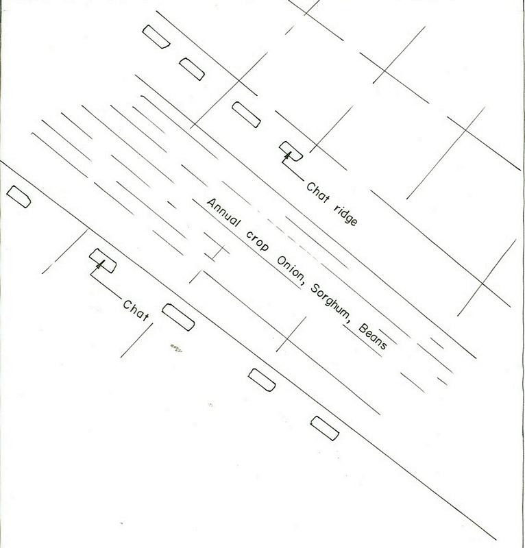
Technical specifications (related to technical drawing):
Harari
Technical knowledge required for field staff / advisors: moderate
Technical knowledge required for land users: moderate
Main technical functions: increase of infiltration, increase / maintain water stored in soil, water harvesting / increase water supply
Secondary technical functions: control of dispersed runoff: retain / trap, reduction of slope length
Early planting
Material/ species: sorghum
Relay cropping
Material/ species: legume/sorghum
Mixed cropping / intercropping
Material/ species: beans sorghum
Contour planting / strip cropping
Material/ species: Chat, sorghum, onion
Aligned: -contour
Vegetative material: C : perennial crops
Scattered / dispersed
Vegetative material: F : fruit trees / shrubs
Trees/ shrubs species: Cordia, Acacia, Mango
Perennial crops species: Chat
Slope (which determines the spacing indicated above): 10.00%
Gradient along the rows / strips: 0.00%
Bund/ bank: level
Spacing between structures (m): 1-5
Depth of ditches/pits/dams (m): 0.3-0.4
Width of ditches/pits/dams (m): 2-3
Length of ditches/pits/dams (m): 3-4
Height of bunds/banks/others (m): 0.3
Width of bunds/banks/others (m): 0.5
Length of bunds/banks/others (m): 70-80
Construction material (earth): earth bunds
Slope (which determines the spacing indicated above): 8%
If the original slope has changed as a result of the Technology, the slope today is: 4%
Lateral gradient along the structure: 1%
4.2 General information regarding the calculation of inputs and costs
other/ national currency (specify):
Birr
If relevant, indicate exchange rate from USD to local currency (e.g. 1 USD = 79.9 Brazilian Real): 1 USD =:
8.6
Indicate average wage cost of hired labour per day:
0.85
4.3 Establishment activities
| Activity | Timing (season) | |
|---|---|---|
| 1. | seed bed preparation | Dry season |
| 2. | preparing cutting | rainy season |
| 3. | cutting plantation | rainy season |
| 4. | cultivation | after rain |
| 5. | Protect from free grazing animals | especially after crop harvest. |
4.4 Costs and inputs needed for establishment
Comments:
Duration of establishment phase: 24 month(s)
4.5 Maintenance/ recurrent activities
| Activity | Timing/ frequency | |
|---|---|---|
| 1. | Digging | before rains / each cropping season |
| 2. | Cultivation and weeding | mid of rains / twice a year |
| 3. | replanting of dead cuttings | May, June /during rain |
| 4. | cultivation | July /during rain |
| 5. | reridging of breaks | September /after rain |
4.6 Costs and inputs needed for maintenance/ recurrent activities (per year)
Comments:
Machinery/ tools: hand tools
Volume of earth excavated and moved.
5. Natural and human environment
5.1 Climate
Annual rainfall
- < 250 mm
- 251-500 mm
- 501-750 mm
- 751-1,000 mm
- 1,001-1,500 mm
- 1,501-2,000 mm
- 2,001-3,000 mm
- 3,001-4,000 mm
- > 4,000 mm
Agro-climatic zone
- semi-arid
5.2 Topography
Slopes on average:
- flat (0-2%)
- gentle (3-5%)
- moderate (6-10%)
- rolling (11-15%)
- hilly (16-30%)
- steep (31-60%)
- very steep (>60%)
Landforms:
- plateau/plains
- ridges
- mountain slopes
- hill slopes
- footslopes
- valley floors
Altitudinal zone:
- 0-100 m a.s.l.
- 101-500 m a.s.l.
- 501-1,000 m a.s.l.
- 1,001-1,500 m a.s.l.
- 1,501-2,000 m a.s.l.
- 2,001-2,500 m a.s.l.
- 2,501-3,000 m a.s.l.
- 3,001-4,000 m a.s.l.
- > 4,000 m a.s.l.
Comments and further specifications on topography:
Landforms: Also hill slopes (ranked 2) and ridges (ranked 3)
Slopes on average: Also hilly (ranked 2) and steep and gentle (both ranked 3)
5.3 Soils
Soil depth on average:
- very shallow (0-20 cm)
- shallow (21-50 cm)
- moderately deep (51-80 cm)
- deep (81-120 cm)
- very deep (> 120 cm)
Soil texture (topsoil):
- coarse/ light (sandy)
- medium (loamy, silty)
Topsoil organic matter:
- low (<1%)
If available, attach full soil description or specify the available information, e.g. soil type, soil PH/ acidity, Cation Exchange Capacity, nitrogen, salinity etc.
Soil fertility is low (ranked 1), medium (ranked 2), very low (ranked 3)
Soil drainage/infiltration is good
Soil water storage capacity is low (ranked 1) and medium (ranked 2)
5.6 Characteristics of land users applying the Technology
Market orientation of production system:
- mixed (subsistence/ commercial)
- commercial/ market
Off-farm income:
- less than 10% of all income
Relative level of wealth:
- average
- rich
Level of mechanization:
- manual work
Indicate other relevant characteristics of the land users:
Population density: 100-200 persons/km2
Annual population growth: 2% - 3%
5% of the land users are rich.
70% of the land users are average wealthy.
25% of the land users are poor.
Off-farm income specification: Land users who have SWC measures on their land have lower off-farm income compared to those who have no SWC measures on their land.
Market orientation of production system: mixed (Sorghum: mostly used at home and partly sold) and commercial/ market ( Livestock (cows, goat) are mostly stallfed. In lower parts of the technology area livestock are let to graze openly. This part is a very dry area and there is large area for grazing. Goats browsing open)
5.7 Average area of land used by land users applying the Technology
- < 0.5 ha
- 0.5-1 ha
- 1-2 ha
- 2-5 ha
- 5-15 ha
- 15-50 ha
- 50-100 ha
- 100-500 ha
- 500-1,000 ha
- 1,000-10,000 ha
- > 10,000 ha
Comments:
Land holding is extremely low
6. Impacts and concluding statements
6.4 Cost-benefit analysis
How do the benefits compare with the establishment costs (from land users’ perspective)?
Short-term returns:
positive
Long-term returns:
very positive
How do the benefits compare with the maintenance/ recurrent costs (from land users' perspective)?
Short-term returns:
positive
Long-term returns:
very positive
6.5 Adoption of the Technology
Of all those who have adopted the Technology, how many did so spontaneously, i.e. without receiving any material incentives/ payments?
- 0-10%
Comments:
100% of land user families have adopted the Technology with external material support
Comments on acceptance with external material support: estimates
There is a strong trend towards spontaneous adoption of the Technology
Comments on adoption trend: more and more land users are getting engaged with the technology.
6.7 Strengths/ advantages/ opportunities of the Technology
| Strengths/ advantages/ opportunities in the land user’s view |
|---|
| Efficient in rainwater harvesting |
| Laid out by farmers with little technical support |
| Strengths/ advantages/ opportunities in the compiler’s or other key resource person’s view |
|---|
|
Highly flexible How can they be sustained / enhanced? change of structures (size, position) possible |
|
Material needed is locally available How can they be sustained / enhanced? soil and stone are found everywhere |
|
Low cost How can they be sustained / enhanced? tools available at local markets |
7. References and links
7.1 Methods/ sources of information
Links and modules
Expand all Collapse allLinks
No links
Modules
No modules